Home A - Z FAQ Bookstore Art Prints Online Library Discussion Forum Muir Weather Maps Lodging About Search
CalHotels.US--online reservations now CalHotels.US Lowest Hotel Rates Guaranteed. Click Here For Yours!
Hotel photos, maps, reviews, & discount rates.

U.S. Hotels in California (Yosemite, L. A., San Francisco ), AL, AK, AR, AS, AZ, CA, CO, CT, DC, DE, FL, FM, GA, GU, HI, ID, IL, IN, IA, KS, KY, LA, ME, MD, MA, MI, MN, MS, MO, MT, NE, NH, NJ, NY, OK, NV, MH, MP, NM, NC, ND, OH, OR, PA, PR, PW, RI, SC, SD, TN, TX, UT, VT, VA, VI WA, WV, WI, WY

[Yosemite]

3 night 4 day trip help?

Hiking, backpacking, running, biking, climbing, rafting, and other human-powered activities in Yosemite National Park

Moderators: Wickett, dan

Postby bill-e-g » Thu Apr 16, 2009 6:17 pm

The other reason I gave May Lake and Glen Aulin is b/c there are
backpacker campgrounds there and you will then maybe not need
a huge number / if any / bear canisters. I stear clear of those areas
tho so not 100% positive on May Lake.

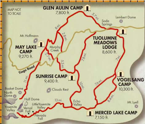
Anyway, you need to get yourself a map. The trails are simple to
follow and very well marked tho.

I'm off to the woods now myself. See ya
User avatar
bill-e-g
Veteran-poster
Veteran-poster
 
Posts: 795
Joined: Tue Jun 24, 2008 5:57 am
Location: Table Lake, YNP

Postby john » Thu Apr 16, 2009 6:58 pm

Yeah Bill's right...I failed to mention that it can be a long day for some people to get there. Most people that I've draged along will agree that it is worth it once you get there, especially if you have a few days to enjoy the area.

If your groups up for it, the trail is pretty easy to follow, I've done it on a moonless night. Just follow the trail on the north side of Tioga rd at the Ten Lakes TH (trailhead). The only part that is slightly tricky comes about a mile or so into the hike. You start to climb the ridge (on the west side of Yosemite creek) and the trail moves through some granite slabby areas. The key here is to look for the cairns (little piles of rocks stacked on each other) that mark the trail. When you crest the top of Ten Lakes Pass and start to descend, the Ten Lakes area will be very obvious. You will only be able to see 3 of the lakes but head for the biggest one that is surrounded by forest. There are some real nice campsites near the outlet of this lake.

One caution; make SURE to filter all your water as this spot is popular and you will be sorry if you don't :shock:

Have FUN!
User avatar
john
Frequent poster
Frequent poster
 
Posts: 34
Joined: Sat Mar 31, 2007 10:03 am
Location: napa

Postby nathanwellsfry » Thu Apr 16, 2009 8:23 pm

Could i get a link to the map of the lake trail? i found the website all together very overwhelming. Sorry i'm so needy :?
nathanwellsfry
Regular
Regular
 
Posts: 15
Joined: Mon Apr 13, 2009 3:19 pm

Postby dan » Fri Apr 17, 2009 12:51 pm

Here's a link. It's just a short walk from the side road (off of Tioga Road) to May Lake:
http://www.yosemitehikes.com/tioga-road ... il-map.htm

Here's a simple map of the High Sierra Camps (not detailed enough for use on the trail):
http://www.yosemite.ca.us/maps/high_sierra_camp_map.jpg
User avatar
dan
Veteran-poster
Veteran-poster
 
Posts: 822
Joined: Sat Jan 20, 2007 9:06 pm
Location: California, USA

Postby nathanwellsfry » Fri Apr 17, 2009 6:03 pm

Thanks everyone!

One last set of questions, will i have to worry about any poison oak at may lake?

And what are the names of the lakes or bodies of water to the left of may lake?

Lastly fire permits, could i get them by walking up the day of for the three nights or not?
nathanwellsfry
Regular
Regular
 
Posts: 15
Joined: Mon Apr 13, 2009 3:19 pm

Postby hiker97 » Sat Apr 18, 2009 12:57 pm

You might appreciate the information out on the web as well - just Google "Ten Lakes Basin" and you'll get lots of great info, previous photos, etc. We did this hike last year in mid-June and it was great. We had a group of eight and found a good area by the first lake you hit. Don't worry about the ascent to 10 Lakes Pass...as long as you start out by mid-morning, you can take your time on the 6.5 mile hike to 10 Lakes Basin and will for sure make it by dinner time. Mid-June was ideal in 2008 as there was still snow on the ground in small patches, full streams and really cool water features. And the mosquitoes, although they had hatched, were busy with each other in little groups and had not yet started biting! The trailhead starts on Highway 120 at the same point as the Yosemite Creek trailhead, but 10 Lakes heads north from Hwy 120. It goes to Half Moon Meadow which should very green and gorgeous that time of year. Then you get serious and ascend the switchbacks up to 10 Lakes Pass. This takes you up where you can see for miles and miles. Or if you can't get the 10 Lakes trailhead, the other option to get there is out of May Lake, but this is longer with more passes/ridges/etc - if you enjoy panoramas it's a spectacular route. Once you're at 10 Lakes Basin, be sure to take a short day hike north of the lakes toward the Grand Canyon of the Tuolumne. The lakes have several outlet streams that make for an amazing group of cascades and waterfalls as they roar down toward the GCT. We only had time on our trip to explore 2 lakes plus the cascades - you should have opportunity to hike all over the basin to see the upper and lower lakes in that area.
hiker97
Very frequent poster
 
Posts: 69
Joined: Fri Aug 08, 2008 10:21 pm
Location: Central Valley, CA

Postby dan » Sat Apr 18, 2009 10:50 pm

nathanwellsfry wrote:will i have to worry about any poison oak at may lake?

Poison Oak doesn't grow that high. No snakes that high either. 'Skeeters and bears are your problem (and can be managed with bug juice/camping in dry areas, and bear canisters, respectively.

nathanwellsfry wrote:And what are the names of the lakes or bodies of water to the left of may lake?

Mt. Hoffmann is to the left (west) of May Lake. There are some dinkey little glacier lakes over the ridge, but the ridge is too high/dangerous to cross.

nathanwellsfry wrote:Lastly fire permits, could i get them by walking up the day of for the three nights or not?

Wilderness Permits are needed. Not sure--a day ahead is a better bet. You should get acclimatized at least overnight in any case.
User avatar
dan
Veteran-poster
Veteran-poster
 
Posts: 822
Joined: Sat Jan 20, 2007 9:06 pm
Location: California, USA

Postby nathanwellsfry » Sun Apr 19, 2009 10:12 pm

What's the elevation of May Lake? i live at 3500
nathanwellsfry
Regular
Regular
 
Posts: 15
Joined: Mon Apr 13, 2009 3:19 pm

Postby bill-e-g » Sun Apr 19, 2009 11:34 pm

Dude, no disrespect but get a map.
Anyway, May Lake is about 9300ft.

from the TH it's only 1.2 miles in and about 500 ft. up
User avatar
bill-e-g
Veteran-poster
Veteran-poster
 
Posts: 795
Joined: Tue Jun 24, 2008 5:57 am
Location: Table Lake, YNP

Postby nathanwellsfry » Mon Apr 20, 2009 4:57 pm

None taken i'm needy and helpless, i spent 6 hours trying to plan a trip off of google and got nowhere then i found this forum.
nathanwellsfry
Regular
Regular
 
Posts: 15
Joined: Mon Apr 13, 2009 3:19 pm

Postby bill-e-g » Mon Apr 20, 2009 5:18 pm

I'd recommend you buy yourself this map:

http://www.amazon.com/Trails-Illustrate ... 976&sr=8-3

It has trail mileage on it and topographic info.
It's the one they have at the wilderness centers/permit stations.

As you've found out... it's a big park.
User avatar
bill-e-g
Veteran-poster
Veteran-poster
 
Posts: 795
Joined: Tue Jun 24, 2008 5:57 am
Location: Table Lake, YNP

Postby balzaccom » Mon Apr 20, 2009 8:18 pm

Actually, get a book, too.

"Yosemite National Park" by Jaffrey Shaffer, from Wilderness Press, will give you more info than you can get by picking our brains, one question at a time, for a year.

And it will also teach you a lot about the history and geology of the park...and start you on a list of hikes you'll want to take on your next trip.
balzaccom
Veteran-poster
Veteran-poster
 
Posts: 1702
Joined: Sat Nov 22, 2008 7:51 am
Location: Napa CA

Postby nathanwellsfry » Wed Apr 22, 2009 5:30 pm

Alright, i'll do that. Thanks for your help everyone! Getting my trip put together now! 8)


Er one last monkey wrench, can i get a permit to have a campfire or is that a permit to sleep somewhere.
nathanwellsfry
Regular
Regular
 
Posts: 15
Joined: Mon Apr 13, 2009 3:19 pm

Postby hiker97 » Wed Apr 22, 2009 9:31 pm

Your permit and destination will dictate campfire limitations. Within Yosemite, your wilderness permit allows for campfires in certain areas. Ten Lakes is typically an allowed campfire area and there would be ample wood in the area. It's encouraged for backpackers to do without if they can for environmental and leave no trace reasons, but if you do desire to have one, Ten Lakes has established camp fire rings in the regularly used lakes.
hiker97
Very frequent poster
 
Posts: 69
Joined: Fri Aug 08, 2008 10:21 pm
Location: Central Valley, CA

Postby john » Thu Apr 23, 2009 5:29 pm

Some campfire rules:

1. No campfires above 9600'. The national geographic maps actually show this on their topo lines.

2. Only use established rings. Do not build new ones.

3. Use only dead downed wood.

Abide by these rules and your good to go, no special permit needed.
User avatar
john
Frequent poster
Frequent poster
 
Posts: 34
Joined: Sat Mar 31, 2007 10:03 am
Location: napa

PreviousNext

Return to Yosemite Hiking & Backpacking

Who is online

Users browsing this forum: No registered users and 98 guests

cron