Home A - Z FAQ Bookstore Art Prints Online Library Discussion Forum Muir Weather Maps Lodging About Search

Rim Fire today

Hiking, backpacking, running, biking, climbing, rafting, and other human-powered activities in Yosemite National Park

Moderators: Wickett, dan

Rim Fire today

Postby balzaccom » Tue Oct 01, 2013 11:35 am

We're back from a short backpacking trip to Yosemite (we'll post a Trip Report in the future) but we thought you might be interested in seeing just exactly what the damage from the Rim Fire looks like as you drive by some of the burn area on Highway 120 through Big Oak Flat and into Yosemite.

The good news? There are huge parts of this fire that are described as having burned---and yet still have plenty of green trees in place. The fire in these areas was obviously not so hot, and burned only the understory of the forest. In fact, the larger trees seemed to do better, probably because their lower branches had long since fallen away, and there was little to catch fire at that lower level. As long as the bark and cambium layer wasn't damaged, those trees are fine.

Image

The first photo shows an overview of the section of the fire that burned in Yosemite...with both green trees and burn damage.

And Highway 120, at forty feet wide or so, was a pretty good firebreak in a lot of areas. You can see where the fire burned the understory on one side of the highway, but the fire crews were able to keep it from crossing into the forest on the other side of the road. Nice work.

There are also some areas where the only thing that didn't burn is the building along the road---as the fire burned the entire forest right up to the edge of the buildings.
Image

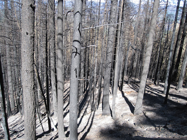
But there are also scenes of real devastation--whole sections of the forest that are now just burnt sticks. This is between the Big Oak Flat Entrance Station and Crane Flat. They are clearly trying to log some of these areas right now, so that the fire danger doesn't get even worse...and some of that lumber can be salvaged. But other areas are just burnt to a crisp. The trees are all dead, the foliage is burnt off, and the ground is black and white ashes.

It's hard to imagine these areas making a quick comeback, and we've all hiked through enough burned areas to know that ten years from now, many of these black stumps will still be the tallest things in this part of the forest.

Image

We were particularly saddened by this fire damage up the side of one of Yosemite's distinctive granite domes. Those trees, which took centuries to grow that big, will never come back in our lifetime. The first clearly shot right up the side of the dome, and burned everything until it ran out of fuel.

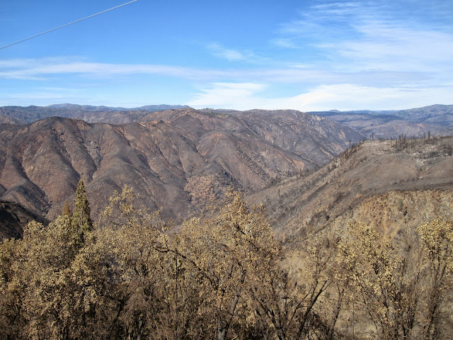
And as a final note, the view from the Rim of the World is pretty desolate. Here there was as much brush as trees, and it all went up in smoke. Most of what you can see from this overlook is black soil--and only a few tiny spots where something green might still be living.
Image

And yes, there are still a few tiny spots in the middle of this devastation where there is something green still alive.

And feeling very lonely.
Check our our website: http://www.backpackthesierra.com/
Or just read a good mystery novel set in the Sierra; https://www.amazon.com/Danger-Falling-Rocks-Paul-Wagner/dp/0984884963
balzaccom
Veteran-poster
Veteran-poster
 
Posts: 1725
Joined: Sat Nov 22, 2008 7:51 am
Location: Napa CA

Re: Rim Fire today

Postby DavinW » Tue Oct 01, 2013 1:07 pm

Thanks for posting! We were in Yosemite two weeks ago, just after the Tioga Road re-opened, and we saw the same fire break patterns on the side of Hwy 120 as you guys did. We also saw those sad stumps on the stretch from Crane Flat along Big Oak Flat Road.

I live in San Diego, and go hiking all over San Diego County. We had some severe fires in the County in 2006-2007, and much of those areas are also still covered in the black, ashy monuments of burned-out conifers. The sight is especially sad in Southern California, where the desert climate permits such tall and magnificent ancient conifers only on the very highest mountain ridges. A short hike in the Cuyamaca Mountains in eastern San Diego County offers the best evidence of this loss. Nonetheless, I was heartened while hiking through these areas, as even now, just 6-7 years after the fires, smaller conifers and green vegetation are sprouting up all over the hillside. Many other burned out trails all over San Diego County are greening up again! But the loss of those tall, ancient conifers is truly devastating.

Thanks for all you do!
DavinW
Newbie
Newbie
 
Posts: 6
Joined: Wed Aug 28, 2013 11:28 am

Re: Rim Fire today

Postby Grzldvt » Wed Oct 02, 2013 12:28 am

Let me add.
Here is a very cool video of a C130 dropping retardant around Camp Mather
https://www.youtube.com/embed/c_eGiGG1B-Q
Here are my pics from the view point on 120
Image

Image

Image

Image
Steve
Grzldvt
Veteran-poster
Veteran-poster
 
Posts: 381
Joined: Sat Mar 31, 2007 10:18 pm
Location: Coarsegold, CA


Return to Yosemite Hiking & Backpacking

Who is online

Users browsing this forum: No registered users and 1 guest