Home A - Z FAQ Bookstore Art Prints Online Library Discussion Forum Muir Weather Maps Lodging About Search
CalHotels.US--online reservations now CalHotels.US Lowest Hotel Rates Guaranteed. Click Here For Yours!
Hotel photos, maps, reviews, & discount rates.

U.S. Hotels in California (Yosemite, L. A., San Francisco ), AL, AK, AR, AS, AZ, CA, CO, CT, DC, DE, FL, FM, GA, GU, HI, ID, IL, IN, IA, KS, KY, LA, ME, MD, MA, MI, MN, MS, MO, MT, NE, NH, NJ, NY, OK, NV, MH, MP, NM, NC, ND, OH, OR, PA, PR, PW, RI, SC, SD, TN, TX, UT, VT, VA, VI WA, WV, WI, WY

[Yosemite]

Tenaya Creek Camping

Discussion of camping and road-accessible campgrounds in and near Yosemite National Park

Moderators: Wickett, dan

Tenaya Creek Camping

Postby jgriff251 » Wed Jul 11, 2018 8:43 am

Hey everyone!

I am looking for a comfy place to camp the second night into my backountry trip in yosemite. The first day we are going up yosemite falls trail and camping around north dome. The second day we are coming down the snow creek trail to meet the mirror lake trail. From here I was planning on going off trail and following Tenaya Creek up and away from the valley towards snow creek falls keeping an eye out for a nice spot to call home for the night.

Does anyone have any experience camping in this area? Shady spots, good access to water, views!?!

Any and all help appreciated, thanks in advance!!
jgriff251
Newbie
Newbie
 
Posts: 7
Joined: Sun Jul 08, 2018 11:11 am

Re: Tenaya Creek Camping

Postby AlmostThere » Wed Jul 11, 2018 7:41 pm

You can't camp up there. When you get to the valley floor you are outside the wilderness boundary. Exiting the wilderness means you need another wilderness permit to re-enter, and there is no legal way to camp up Tenaya Creek.

Go instead to the backpacker campground, which you can use for 5/person for one night prior to and one night following your backpacking trip.
AlmostThere
Veteran-poster
Veteran-poster
 
Posts: 2077
Joined: Fri May 15, 2009 6:57 pm
Location: Central Valley California

Re: Tenaya Creek Camping

Postby Phil » Wed Jul 11, 2018 9:17 pm

To exit from Snow Creek, you leave the wilderness. They won't give you a wilderness permit for the canyon. You can't camp there anyhow. You have the lower gorge, then it gets 50 feet wide and rockslides are common. It's haunted, and it's a good place to die. And the Mirror Lake trail is a footpath for tourists all the way back to the bridge that connected what was once the loop until a big chunk of Ahwiyah Point fell on it.

You should get above the restricted area beyond the footbridge up top and camp there, then do as AT says and stay at the backpackers camp.

Here's where it's closed at Snow Creek:

https://www.nps.gov/yose/learn/management/closures.htm

Still plenty of good sites to the right of the trail beyond the closure area with views if you walk out just a bit.
Phil
Veteran-poster
Veteran-poster
 
Posts: 1335
Joined: Mon Jun 08, 2015 5:02 am
Location: Healdsburg, Ca

Re: Tenaya Creek Camping

Postby jgriff251 » Thu Jul 12, 2018 6:04 am

Phil wrote:To exit from Snow Creek, you leave the wilderness. They won't give you a wilderness permit for the canyon. You can't camp there anyhow. You have the lower gorge, then it gets 50 feet wide and rockslides are common. It's haunted, and it's a good place to die. And the Mirror Lake trail is a footpath for tourists all the way back to the bridge that connected what was once the loop until a big chunk of Ahwiyah Point fell on it.

You should get above the restricted area beyond the footbridge up top and camp there, then do as AT says and stay at the backpackers camp.

Here's where it's closed at Snow Creek:

https://www.nps.gov/yose/learn/management/closures.htm

Still plenty of good sites to the right of the trail beyond the closure area with views if you walk out just a bit.


I already have my permits, and originally I told the ranger we are starting yos falls, coming down snow creek through the valley over to half dome. We can hit the valley floor, as long as we do not enter the front country the permit is still valid.
Referring to that attached maps, we wouldn't be able to follow the creek and clear the wilderness boundary line to set up camp?
jgriff251
Newbie
Newbie
 
Posts: 7
Joined: Sun Jul 08, 2018 11:11 am

Re: Tenaya Creek Camping

Postby Phil » Thu Jul 12, 2018 6:44 am

I'm not clear on a couple of things;

It's odd that you would have been given a permit for HD when it's not on your route and it would require exit at Mirror Lake, then picking up the JMT at Happy Isles, reentering at another trailhead to pickup HD. HD permits for backpackers are generally only attached to their wilderness permits when it can be done en-route, not as a separate destination. But, if it's written, and you were stopped and asked for the permit, it would probably be allowed to fly.

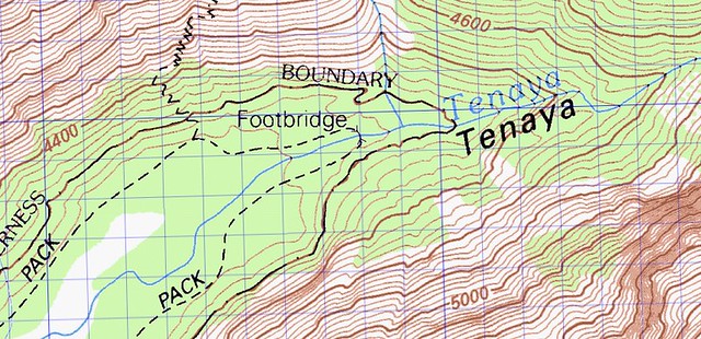
Secondly, the base of the Snow Creek switchbacks is decidedly front country, and that designation continues north in Tenaya Canyon at least up past the footbridge on the Mirror Lake trail. Hitting the valley floor is automatic front country by the map and by regulations.

jgriff251 wrote:Referring to that attached maps, we wouldn't be able to follow the creek and clear the wilderness boundary line to set up camp?


I'm not sure if I'm quite clear on what you're asking here with this last question. Are you asking if there's a way to drop down from either the top of Snow Creek or along the switchbacks down to the valley and hit Tenaya Canyon further back, thereby skirting the wilderness boundary? If so, then I would have to say that there's no way in hell without ropes and climbing gear. For all intents and purposes, that is a cliff...a big cliff...a couple thousand feet of cliff. Snow Creek terminates a couple hundred yards below the footbridge with Snow Creek Falls, which then cascades over boulders the the size of cars for about 2500 ft of overall vertical drop. And where it isn't a cliff or a waterfall, it's loose rock and talus further down the switchbacks. And even if you got down it without dying, I seriously doubt that you would find an adequate site without ending up going down canyon and ending up inside the front country boundary. It might be an adventure, but it wouldn't be worth the effort. I'm sorry, but if you're not seeing it, you're not looking at a topo map, and I can tell you from many times up there on the North Rim in that area and knowing exactly where you're going very well, that what you're thinking about is not something you want to be considering without also realizing that death or serious rescue should be examined in the same process. Believe me, you'll stand at the top and reconsider it immediately.
Phil
Veteran-poster
Veteran-poster
 
Posts: 1335
Joined: Mon Jun 08, 2015 5:02 am
Location: Healdsburg, Ca

Re: Tenaya Creek Camping

Postby AlmostThere » Thu Jul 12, 2018 7:02 am

This sounds like a case of office volunteer not knowing the regulations or the terrain. The law enforcement rangers who actually know the trails, boundaries and rules would not have advised you thusly. Unfortunately the folks in offices and campgrounds are not always fully informed. Have had a camp host tell us we could carry bear spray, for example, which is illegal.... I have had to clarify permit issuing volunteer instructions before.

Look at a map. The wilderness boundary is shown. You cannot cross the valley floor and go to Happy Isles on a permit. It is not wilderness and never has been.
AlmostThere
Veteran-poster
Veteran-poster
 
Posts: 2077
Joined: Fri May 15, 2009 6:57 pm
Location: Central Valley California

Re: Tenaya Creek Camping

Postby Phil » Thu Jul 12, 2018 7:31 am

I'll give you a minor example of what AT is talking about from last week. We got our permit for Mono Meadow. Route stated as over Red Peak and down the Merced. Obvious exit at Happy Isles. The permitting ranger initially listed my exit as Mono Meadows. An in-and-out as opposed to a loop. I had him correct it for my own protection. A minor glitch by comparison to getting caught leaving the wilderness and re-entering somewhere at another trailhead, but still a permitting error not of my own making that needed to be fixed. But if a potential $300 citation and and an end to your trip right then and there, then beyond that, getting to sort it all out and defend your case by proving that you were given grossly inaccurate info while standing in front of a judge in federal court is part of the plan, don't bother to clarify. AT is absolutely right: your trip isn't legally doable under a single permit, as you've been led to understand that it is. It just isn't. There's a real immutable bottom line here that you need to understand and respect for your own sake.
Last edited by Phil on Thu Jul 12, 2018 7:54 am, edited 1 time in total.
Phil
Veteran-poster
Veteran-poster
 
Posts: 1335
Joined: Mon Jun 08, 2015 5:02 am
Location: Healdsburg, Ca

Re: Tenaya Creek Camping

Postby AlmostThere » Thu Jul 12, 2018 7:52 am

If only because Yosemite has more enforcement rangers than anywhere else, and people do in fact get tossed out of the park and fined - something between 300-500 smackers, for not having the right wilderness permit, I think. Which you would not have....

Image

See how close the contour lines on Snow Creek trail are?

See how the wilderness boundary runs around all that trail in the valley floor?

See how close the contour lines are up Tenaya Creek?

Great places to injure yourself if you aren't into canyoneering or climbing.

And doing Half Dome using the permit you have - legally - will require hiking onward to the north, not coming down Snow Creek - going on actual wilderness trails up toward Tenaya Lake, then across and over the ridge toward Clouds Rest, then DOWN toward Half Dome. Many more miles and many more feet of gain (and loss), at least a day or two more of hiking unless you're superhuman.
AlmostThere
Veteran-poster
Veteran-poster
 
Posts: 2077
Joined: Fri May 15, 2009 6:57 pm
Location: Central Valley California

Re: Tenaya Creek Camping

Postby Phil » Thu Jul 12, 2018 8:25 am

In reference to the other thread you started on the subject, I also have to say that if you don't know it from experience, and you're not used to the type of climbing and vertical gain involved with the Falls Trail, hitting North Dome for most people on the first day is a pipe dream. I would bet that you're ready to drop by the time you hit the top, and then you'll only find dry campsites until you hit Lehamite Creek. At that point, regardless of whatever, you commit, and you have no choice but to keep going and suffer or backtrack and compromise. To make North Dome, once at Lehamite Creek, you then load up with probably 6-8 lbs of additional water weight per person and climb some more. You might be able to pull it off, but you would be better off just heading up Yosemite Creek that night and finding a better site with water (minimum 1/4 mile from the brink of the falls...Eagle Peak Trail or just beyond), then have an easier second day over to North Dome beyond that.

I can plan with great aspirations all the time, but if I'm not being entirely honest with myself, or at least somewhat familiar with my route, it doesn't serve me as well as taking a realistic approach before I set foot on dirt, and being better off for it. Again, I'm sorry, and maybe I'm absolutely wrong, but in not knowing the topo lines down off Snow Creek, I have to question you on how much you've really been examining and understanding your maps and what they're telling you about what you're facing.

We try to help people plan great trips by giving recommendations that work, keep them safe, and keep them real, not setting them up for failure and maybe killing them. You maybe had some bad info...we're trying to correct that by giving you what you need to make this trip what you want it to be.
Phil
Veteran-poster
Veteran-poster
 
Posts: 1335
Joined: Mon Jun 08, 2015 5:02 am
Location: Healdsburg, Ca

Re: Tenaya Creek Camping

Postby AlmostThere » Thu Jul 12, 2018 9:05 am

The logistics of hiking - so much fun.

I recently did 40 miles in five days. Sounds easy, until you factor in that we started low - Kings Canyon is at 4000 feet, and is as hot as the central valley, twas 80F at 10 pm - so climbing switchbacks was HOT, making for sweaty hard crawling up granite steps. We climbed Avalanche Pass to the first campsite at a creek, at around 7k. One of our group suffered some heat exhaustion - something you should understand before you climb out of Yosemite valley. The following day we finished the climb to 10k at the pass and dropped to Roaring River, around 7k, where it was again pretty hot in the afternoon. Thank goodness for cool river water. Then we climbed back up to 9k over the following day, about 7 miles of gradual walking uphill through meadows, which was quite nice - less hot. Then we went to 11k on open rock switchbacks - which was not bad as we started at cooler high elevation, but steeper. And THEN we went off trail, which automatically doubles the difficulty and the time it takes to do it.

Temperature, steepness, complexity of route finding, all go into determining level of difficulty. It's not so simple as mileage. Add in park regulatory limitations due to their obligation to protect the wilderness from overuse, and it can be difficult to plan trips. Yosemite is one of the most heavily used parks in the system. Anything within a day's walk of the valley floor in Yosemite has a labyrinth of no camping zones, rules and bans to navigate.

It's in the 80s in Yosemite Valley this week. That's hotter than I like for putting on a pack and hiking up any of the trails from those trailheads. It will feel horrible in the open sun on the granite, between 4k and 7k. I would be getting up at 4 am to beat that sunshine, hike in the cool morning hours, stop at 11 am for a long siesta, hopefully near water but in shade at least, and then start hiking again at 4 pm.
AlmostThere
Veteran-poster
Veteran-poster
 
Posts: 2077
Joined: Fri May 15, 2009 6:57 pm
Location: Central Valley California

Re: Tenaya Creek Camping

Postby Phil » Thu Jul 12, 2018 2:32 pm

For the time being, I just want to add one more thing: You do not, in fact, have a permit yet. You only have a reservation for a permit. All permits have to be picked up in person and signed for. In your case, that'll likely be at the Valley Wilderness Office. That's a busy station with only the most savvy rangers staffing it. I think those of us that know the drill would be utterly dumbfounded if they let what you say you have approved get through once it reaches that point. From your standpoint, what you do have is an already approved HD permit amendment waiting with your trip of what you're thinking is going to be three days. Having that, I'm assuming it's important for you to hang on to. Routes can always be varied once you're out in the wilderness, but if you've planned your food, your water sources, your camping locations based on daily miles and legality, departure times for heat, etc, and they kill what you thought was good to go, you're going to scramble to make some serious adjustments to all of it.

My best advice at this point is for you to call the permitting phone number and run it past them again, being very precise in letting them know that you want to exit the wilderness at the bottom of Snow Creek, travel over 2 miles through the valley itself in designated front country, and then resume your backcountry trip at Happy Isles under the same permit. Someone either didn't construe your plan correctly, or you didn't convey it clearly, and, using the way to present it I just mentioned, I can almost guarantee you that the next person there you talk to is going to blow it directly out of the water and tell you that the only way they're going to let you do it is by going up from Snow Creek, past Sunrise and CR, and then down the JMT. What you were supposedly granted is a violation of Title 36 CFR as it applies to the Wilderness Act of 1964...and the entire basis for the trail quota system being in place to begin with. And for a paid ranger or volunteer, something that not upholding to the letter, could possibly end their career, or at least get them into very deep trouble.
Phil
Veteran-poster
Veteran-poster
 
Posts: 1335
Joined: Mon Jun 08, 2015 5:02 am
Location: Healdsburg, Ca

Re: Tenaya Creek Camping

Postby jgriff251 » Fri Jul 13, 2018 6:20 am

I think I have learned more from you both on this post then I have in the last 3 weeks of doing research. The ranger I initially spoke to asking all the questions I could think of, made my 30 mile 3 day trip sound completely doable both physically and legally. I understand what you are both saying and know now that my initial plan is simply not doable. I plan on keeping my permit for starting at Yos Falls and will make it a 3 day / 2 night venture up and around North Dome, exiting via Snow Creek + Mirror Lake trail.

To be physically and legally safe, I will look for a good spot to call home between Yos Falls and the start of North Dome for the first night. If we need to set up camp and backtrack for a water run, so be it. Myself and my party are all accustom to intense physical activity and although the switchbacks are brutal, we can make it work. The second night I will search for a good campsite on / around the Snow Creek trail before it dips back into the Valley. I've noticed the closure due to a clever bear, and will work around that if it is still an issue 3 weeks from now. Our 3rd and last day will take us back into the valley to finish off at the backpackers campground.

This is definitely a large variation from my initial itinerary, but that's life right!? I am a Yosemite virgin so thank you for the very helpful insight on planning this trip. My self and my group appreciate you saving us from legal trouble and or a hospital trip!!
jgriff251
Newbie
Newbie
 
Posts: 7
Joined: Sun Jul 08, 2018 11:11 am

Re: Tenaya Creek Camping

Postby Phil » Fri Jul 13, 2018 10:47 am

No worries. Glad it helped.

I'll also tell you that the Falls Trail isn't all that big a shake. It's just really hot and hard. Nice views, but they get kind of lost in the effort it takes, and you'll have just as good and better at the top. You guys should seriously consider entering at the Yosemite Creek trailhead instead; easier, lots more nice sites along the creek, perfect position to take North Dome on the second day. Ask the ranger about current stream flows throughout the area, but 1L each hydration water only above the falls, then reload for the night and morning meals at Lehamite Creek (usually year-round) and take that up to ND, refill at Porcupine or Snow Creek just past the major trail junction at the top of the hill the next day. If it's hot, again refill at or below the Snow Creek footbridge for the switchbacks down.

If you want another day and night, it's dry camping and will require you to hike in water, but consider going uptrail from Snow Creek and camp at the top of Mt Watkins. Incredible Views of HD, CR, Tenaya Canyon.

There you go. Have a great trip.
Phil
Veteran-poster
Veteran-poster
 
Posts: 1335
Joined: Mon Jun 08, 2015 5:02 am
Location: Healdsburg, Ca


Return to Yosemite Campgrounds

Who is online

Users browsing this forum: No registered users and 3 guests