Home A - Z FAQ Bookstore Art Prints Online Library Discussion Forum Muir Weather Maps Lodging About Search
CalHotels.US--online reservations now CalHotels.US Lowest Hotel Rates Guaranteed. Click Here For Yours!
Hotel photos, maps, reviews, & discount rates.

U.S. Hotels in California (Yosemite, L. A., San Francisco ), AL, AK, AR, AS, AZ, CA, CO, CT, DC, DE, FL, FM, GA, GU, HI, ID, IL, IN, IA, KS, KY, LA, ME, MD, MA, MI, MN, MS, MO, MT, NE, NH, NJ, NY, OK, NV, MH, MP, NM, NC, ND, OH, OR, PA, PR, PW, RI, SC, SD, TN, TX, UT, VT, VA, VI WA, WV, WI, WY

[Yosemite]

Recommended Backpacking route for late May?

Hiking, backpacking, running, biking, climbing, rafting, and other human-powered activities in Yosemite National Park

Moderators: Wickett, dan

Recommended Backpacking route for late May?

Postby mdnb2 » Thu Apr 08, 2010 11:53 am

I am planning a trip down to Yosemite around the time of May 26-30. I was initially planning to do Tuolumne Meadows to Happy Valley or vice versa. However, I am unsure if this will be available due to the weather. Could you guys please recommend a good itinerary that would encompass about 20+ miles for a 3 day 2 night trip? I would prefer loop routes. Thanks in advance for your help!
mdnb2
Newbie
Newbie
 
Posts: 3
Joined: Thu Apr 08, 2010 11:43 am

Postby balzaccom » Thu Apr 08, 2010 10:22 pm

Tioga Road will almost certainly still be closed in May...but you could climb up out of the Valley via Snow Creek Falls, and then across North Dome and back donw Yosemite Falls...or work your way up into Little Yosemite Valley. Just about anything over 8,000 will have a lot of snow in May...
balzaccom
Veteran-poster
Veteran-poster
 
Posts: 1702
Joined: Sat Nov 22, 2008 7:51 am
Location: Napa CA

Postby Wickett » Fri Apr 09, 2010 9:57 am

balzaccom wrote:Tioga Road will almost certainly still be closed in May...but you could climb up out of the Valley via Snow Creek Falls, and then across North Dome and back donw Yosemite Falls...or work your way up into Little Yosemite Valley. Just about anything over 8,000 will have a lot of snow in May...


I believe that there is a river crossing between North Dome and Yosemite Falls that will be too treacherous in late May, unless you know of a good spot to cross it, I don't...
Wickett
Veteran-poster
Veteran-poster
 
Posts: 263
Joined: Fri Aug 15, 2008 11:34 am
Location: Sacramento

Postby andykee » Thu Apr 15, 2010 11:10 am

Wickett wrote:I believe that there is a river crossing between North Dome and Yosemite Falls that will be too treacherous in late May, unless you know of a good spot to cross it, I don't...

Do you know which river crossing this is?
andykee
Regular
Regular
 
Posts: 16
Joined: Thu Jul 10, 2008 11:56 am
Location: San Diego, CA

Postby mdnb2 » Tue Apr 27, 2010 11:21 am

I submitted my permit for Yosemite falls and snow creek/mirror lakes loop. How will be the snow levels at those elevations?
mdnb2
Newbie
Newbie
 
Posts: 3
Joined: Thu Apr 08, 2010 11:43 am

Postby bill-e-g » Wed Apr 28, 2010 9:38 am

I mentioned this before. I have never heard Indian Canyon Creek
or Lehemite being an issue to cross. Even at highest flow
you should be able to cross it upstream some via logs.
(wife and I crossed it in winter on snowshoes on a log... so they exist)
Having said this I myself have only been thru later in the year
and in winter.

With the April we are having there will be snow everywhere still
in late May and almost assuredly above 7500 ft. (not atypical anyway).
By then you can usually walk right on top of the snow without
postholing. I'll pretty much go anywhere then w/o snowshoes.
User avatar
bill-e-g
Veteran-poster
Veteran-poster
 
Posts: 795
Joined: Tue Jun 24, 2008 5:57 am
Location: Table Lake, YNP

Postby andykee » Wed May 05, 2010 12:37 pm

Was up this past weekend - did Snow Creek -> North Dome -> Yosemite Falls. Lehamite was an easy crossing (found an enormous log) but Indian Canyon was a bit of a trick. Couldn't find a good spot, so we had to jump it. Not impossible, but definitely not easy either. We spent a good half hour searching for a suitable crossing before giving up.

Also, there were TONS of fresh bear tracks (including some cubs) on both sides of Royal Arch Creek on the way up to North Dome. Didn't see any bears, but they were definitely there.
andykee
Regular
Regular
 
Posts: 16
Joined: Thu Jul 10, 2008 11:56 am
Location: San Diego, CA

Postby mdnb2 » Wed May 05, 2010 2:58 pm

Ahh thank for the update Andy, how were the snow levels up there?
mdnb2
Newbie
Newbie
 
Posts: 3
Joined: Thu Apr 08, 2010 11:43 am

Postby andykee » Thu May 06, 2010 1:46 pm

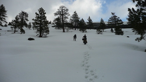
The trail was completely snow-covered above about 6700' on the Snow Creek side. It was pure cross-country travel from the Snow Creek bridge, behind North Dome, up North Dome, and over to Yosemite Point. There were several places where we postholed to our waists (without snowshoes). The trail above Yosemite Falls (to Yosemite Point) was also snow-covered, but you could easily follow people's tracks. I've included a couple of pictures trying to show the snow coverage and depth.

Snow Creek Bridge
Image

Up the west side of North Dome
Image

Somewhere between North Dome and Yosemite Point
Image
andykee
Regular
Regular
 
Posts: 16
Joined: Thu Jul 10, 2008 11:56 am
Location: San Diego, CA

Postby orion » Thu May 06, 2010 9:15 pm

nice.
orion
Veteran-poster
Veteran-poster
 
Posts: 171
Joined: Sun Jan 17, 2010 4:02 pm


Return to Yosemite Hiking & Backpacking

Who is online

Users browsing this forum: No registered users and 270 guests