Home A - Z FAQ Bookstore Art Prints Online Library Discussion Forum Muir Weather Maps Lodging About Search
CalHotels.US--online reservations now CalHotels.US Lowest Hotel Rates Guaranteed. Click Here For Yours!
Hotel photos, maps, reviews, & discount rates.

U.S. Hotels in California (Yosemite, L. A., San Francisco ), AL, AK, AR, AS, AZ, CA, CO, CT, DC, DE, FL, FM, GA, GU, HI, ID, IL, IN, IA, KS, KY, LA, ME, MD, MA, MI, MN, MS, MO, MT, NE, NH, NJ, NY, OK, NV, MH, MP, NM, NC, ND, OH, OR, PA, PR, PW, RI, SC, SD, TN, TX, UT, VT, VA, VI WA, WV, WI, WY

[Yosemite]

Hoover Wilderness/ Northern Yosemite June 18th-22nd

Hiking, backpacking, running, biking, climbing, rafting, and other human-powered activities in Yosemite National Park

Moderators: Wickett, dan

Hoover Wilderness/ Northern Yosemite June 18th-22nd

Postby tblock1 » Tue Jun 22, 2010 6:59 pm

Thanks for the help on our trip, especially to Bill-e-g. We went on our trip and it was absolutely fantastic, lots and lots of snow but no one there. Our original plan was to do a full loop starting Robinson Creek trailhead to Barney lake, Peeler lake, benson lake, rodger's lake, mule pass, and back. But we didnt realize there was snow, so we decided to take it slower. We picked up Yak-tracks at REI on the way (thanks again Bill for recommending those) and stayed at mono village thursday night (got in for free because it we got in and left before they opened their booth haha) and picked up our permit.
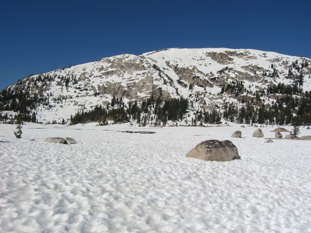
1st day: Mono Village to Peeler lake
2nd day: Peeler to Seavey pass
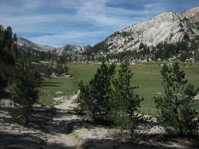
3rd day: Back to kerrick meadow
4th day: Back .25 mile from barney
5th day: back to car

Will put up pictures (we too 500) plus videos and more info later :)
tblock1
Regular
Regular
 
Posts: 10
Joined: Tue Jun 15, 2010 2:14 pm

Postby bill-e-g » Wed Jun 23, 2010 7:35 am

Very very cool.

While I was out myself I was thinking about you guys. Hoping you
went and had a good time. As I was hiking my butt thru some
delicious sun cups near Matthes Lake I figured that you were
probably doing about the same. :)
Thought... if they can make it to Rodgers I'll be hugely impressed.
Bummer you couldn't drop down into Benson. Last year it
was the one spot where we saw anyone. (one person).
This year... the PCTers are probably just swearing at the snow.
Seavey and back is sweet. Congrats! Something I RARELY do
I did last year was swim in that "lake" up there. We had
some mosquitos ... I would guess you barely saw any.
(actually we were carried away by mosq. in Slide Canyon and
at Rodgers..)
So... you now know what I do... going early and late has many
HUGE benefits... and doing an out and back is just as nice
as a loop.. and... the issuing people might now know much.

Post a pict. of Peeler frozen, of what Kerrick Meadows looked like,
and the view from Seavey towards Piute Mtn. please.

So glad you enjoyed yourself and posted
User avatar
bill-e-g
Veteran-poster
Veteran-poster
 
Posts: 795
Joined: Tue Jun 24, 2008 5:57 am
Location: Table Lake, YNP

Postby tblock1 » Wed Jun 23, 2010 2:57 pm

bill-e-g wrote:Very very cool.

While I was out myself I was thinking about you guys. Hoping you
went and had a good time. As I was hiking my butt thru some
delicious sun cups near Matthes Lake I figured that you were
probably doing about the same. :)
Thought... if they can make it to Rodgers I'll be hugely impressed.
Bummer you couldn't drop down into Benson. Last year it
was the one spot where we saw anyone. (one person).
This year... the PCTers are probably just swearing at the snow.
Seavey and back is sweet. Congrats! Something I RARELY do
I did last year was swim in that "lake" up there. We had
some mosquitos ... I would guess you barely saw any.
(actually we were carried away by mosq. in Slide Canyon and
at Rodgers..)
So... you now know what I do... going early and late has many
HUGE benefits... and doing an out and back is just as nice
as a loop.. and... the issuing people might now know much.

Post a pict. of Peeler frozen, of what Kerrick Meadows looked like,
and the view from Seavey towards Piute Mtn. please.

So glad you enjoyed yourself and posted


Yeah actually the problem was the naviagation, we actually couldnt find seavey because the stupid gps was wrong as to where it is, I think it was a flaw on the downloaded map. Actually, me and my friend are both 17 years old, so we could tell when the ranger was giving us the permit that if he could he would stop us. We ended camping day 2 partway into kerrick canyon. We were also worried because the creek, Robinson I guess, was absolutely HUGE and crossing would have been gnarly.


[img][img]http://i601.photobucket.com/albums/tt100/knivesforfun/Northern%20Yosemite/IMG_4664.jpg[/img][/img]

I'll put up more pictures later and some videos but for now this is one side of peeler
tblock1
Regular
Regular
 
Posts: 10
Joined: Tue Jun 15, 2010 2:14 pm

Postby tblock1 » Wed Jun 23, 2010 3:30 pm

tblock1
Regular
Regular
 
Posts: 10
Joined: Tue Jun 15, 2010 2:14 pm

Postby bill-e-g » Wed Jun 23, 2010 3:38 pm

Sweet. Ok, sounds like you made it towards Seavey Pass but didn't
cross Rancheria Creek. Just for the future... for that one I would
have pretty much stayed on the east side of the Creek the
entire way to avoid having to cross it at all.
Just think how it's screaming even further downstream where
the PCT crosses it.
In spring snow melt you really wanna try to be really aware of
exactly where you are b/c you don't wanna be crossing
any snow bridges and fall thru into a body of water.

Anyway, I think you did great. Seems like you used a lot of good
judgement.
Hopefully you can return and do the whole loop.
User avatar
bill-e-g
Veteran-poster
Veteran-poster
 
Posts: 795
Joined: Tue Jun 24, 2008 5:57 am
Location: Table Lake, YNP

Postby tblock1 » Wed Jun 23, 2010 3:48 pm

bill-e-g wrote:Sweet. Ok, sounds like you made it towards Seavey Pass but didn't
cross Rancheria Creek. Just for the future... for that one I would
have pretty much stayed on the east side of the Creek the
entire way to avoid having to cross it at all.
Just think how it's screaming even further downstream where
the PCT crosses it.
In spring snow melt you really wanna try to be really aware of
exactly where you are b/c you don't wanna be crossing
any snow bridges and fall thru into a body of water.

Anyway, I think you did great. Seems like you used a lot of good
judgement.
Hopefully you can return and do the whole loop.


Kerrick Meadow
Image

I'm getting all the pictures from my friend today and will post up a lot more tonight. There were tons of dangerous snow bridges that you could hear the water running beneath you, on some you would fall 5-10 feet and be swept under 100's of yards of underground river if you didnt act quick.

[/img]
tblock1
Regular
Regular
 
Posts: 10
Joined: Tue Jun 15, 2010 2:14 pm

Postby bill-e-g » Thu Jun 24, 2010 8:19 am

Cool.

For fun...
Here's Upper Kerrick Meadow on July 1, 2007:

Image
User avatar
bill-e-g
Veteran-poster
Veteran-poster
 
Posts: 795
Joined: Tue Jun 24, 2008 5:57 am
Location: Table Lake, YNP

Matterhorn Loop

Postby jestein » Wed Jun 30, 2010 4:55 pm

Thanks for the post and pics. I have a trip planned starting 7-10 out of Mono Village->Slide Canyon->Matterhorn Peak->Horse Creek.

I spoke with the ranger you showed your snow covered peeler pictures to and he left us feeling we should reconsider our route.

I would love to see more of your photos from the recent trip. Do you have them posted anywhere?

Thanks,
john
jestein
Newbie
Newbie
 
Posts: 2
Joined: Wed Jun 30, 2010 4:50 pm
Location: San Rafael, CA

Postby bill-e-g » Thu Jul 01, 2010 7:08 am

If you haven't read this you may want to
(this is where he asked about the route)

http://www.yosemite.ca.us/forum/viewtop ... highlight=

You may want to go up Horse Creek first...

I do have a zoom shot of Matterhorn taken from above Elizabeth
from 2 weekends ago if you want to see that.
User avatar
bill-e-g
Veteran-poster
Veteran-poster
 
Posts: 795
Joined: Tue Jun 24, 2008 5:57 am
Location: Table Lake, YNP

Postby bill-e-g » Thu Jul 01, 2010 7:10 am

It's #19 here:

http://picasaweb.google.com/yosemite.chick.on/Matthes

(that was June 20th)
User avatar
bill-e-g
Veteran-poster
Veteran-poster
 
Posts: 795
Joined: Tue Jun 24, 2008 5:57 am
Location: Table Lake, YNP

Up Horse Creek

Postby jestein » Thu Jul 01, 2010 8:44 am

We are planning a 4 day loop. Our thinking was Matterhorn peak on the last day (lighter packs) would be nice as opposed to killing ourselves on day one. However, I have also heard the horse creek route is a better ascent with SW slope being the better descent route.
jestein
Newbie
Newbie
 
Posts: 2
Joined: Wed Jun 30, 2010 4:50 pm
Location: San Rafael, CA

Postby orion » Thu Jul 01, 2010 11:15 am

here's a look down slide from the matterhorn two weeks ago:

http://www.panoramio.com/photo/37299241

horse creek is a great hike right now. the mosquitos are starting to show up, but they weren't too bad.
orion
Veteran-poster
Veteran-poster
 
Posts: 171
Joined: Sun Jan 17, 2010 4:02 pm


Return to Yosemite Hiking & Backpacking

Who is online

Users browsing this forum: No registered users and 231 guests