| Online Library: | Title | Author | California | Geology | History | Indians | Muir | Mountaineering | Nature | Management |
Yosemite > Library > Trip to the Yohamite Valley>
This article was written by Thomas A. Ayres, a San Francisco artist who drew the first sketches of Yosemite Falls as a member of the first tourist party a year earlier. An article about this earlier tourist party was written by James Hutchings in “California For Waterfalls!”
Place names have changed since Mr. Ayres wrote this article: “Cascade of the Rainbow” is Bridalveil Falls, “South Dome” is Half Dome, “South Fork” is Illilouette Creek, “Falls of the South Fork” is Illilouette Falls, “canyon of the Middle Branch” is Little Yosemite Valley, “Lower Falls of the Middle Fork” is Vernal Falls, “Upper Falls of the Middle Fork” is Nevada Falls, and “North Fork” is Tenaya Creek.
| VOL. VII. | SAN FRANCISCO, WEDNESDAY MORNING, AUGUST 6, 1856. | NO. 207. |
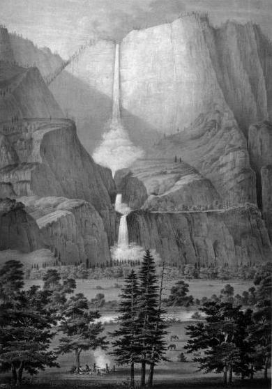
The Yo-Semite Falls Lithograph by Thomas A. Ayres (1855). Not printed with this newspaper article. |
“To him who in the love of Nature
Hold communion with her visible forme,
She speaks a various language.” — Bryant.
Glad to escape the intense excitement which still unfortunately prevails in our city, I left by the Stockton steamer, June 16th, on a second trip to the celebrated Valley of the Yohemity and the sources of the Merced River. Arriving at Stockton next morning, we left by the Sonora coach, reaching Mound Springs at 4 o’clock, P.M. Here the stage was waiting bound to Coulterville, where we arrived safely at 9 o’clock, P.M.
From this point the distance to the valley is some forty miles, and is reached upon mule or horseback. After waiting in vain for several parties who were “about starting” for the valley. Mr. Coulter’s son (a lad of thirteen) and myself concluded our arrangements for the trip. The afternoon of the 23d June saw us off, Master Coulter mounted upon his grey and I with my mule, accompanied by a sandy-complexioned donkey, bearing sundry pockages and bundles necessary for a mountain life.
Passing the “diggins” at the head of Maxwell’s Creek, and ascending the Chemical Mountain, we soon reached the saw mill five miles above Coulterville. Here the pine regions commences. Twilight found us wending our way down the valley of the North Fork of the Merced, and missing our trail at the forks, we reached the vicinity of Wheeler’s Quartz Mill, near which we encamped for the night. Early next morning found us in the saddle, and passing the mill of Capt. Gillsen, soon reached Shreeder’s store at Bull Creek, the poetical name of a branch of the North Fork of the Merced River.
A few miners are located upon this stream and its branches, but the vicinity has not been rich in placer “diggins;” several rich quartz claims occur is the vicinity, however.
After partaking of a hearty breakfast at Shroeder’s, we resumed our journey, and passing up the valley of the Creek, taking the new trail up the left-hand branch, we soon passed the last party of miners near the head of the stream, reaching a fine grassy flat at its source. To the left rose “Pilot Peak,” one of the highest points of the lower mountains, while to the right of the trail lay the valleys of the Merced and its tributaries, the mountains fading away in the dim purple distance. We now reached the dividing ridge between the waters of the Tuolumne and Merced rivers, the trail winding along its summit and through a majestic forest of pines and cedars. Passing “Hazle Green,” a beautiful meadow amid the forest, we made camp some three miles beyond, where we found water and grass for the animals. Below and around us the forest was on fire, and our sleep during the night was disturbed by the crash of the falling timber and the mournful cry of the California lion.
June 25th—A very perceptible change in the temperature has taken place since leaving Coulterville, owing to our increased altitude. The vegetation, also, has a spring appearance—beautiful flowers in bloom upon every side—while at Coulterville and the region below, everything green has disappeared in the summer drought of California. Mounting our animals, we soon reached “Crane Flat,” a large meadow surrounded by the lofty forest, and adorned with brilliant flowers. Here the trail leads to the right, leaving the divide to the left, and descending into the waters of Cascade Creek and its tributaries. Ascending and descending several steep spurs and crossing several streams, we finally caught a glimpse of the everlasting walls of the Yohemity, and farther on we saw gleaming like a silver thread from the dark precipice, the “Cascade of the Rainbow.”
We now commenced the descent into the valley in earnest, and in an hour reached the level of the river, by a good through very steep trail, constructed by the enterprising citizens of Coulterville. Nature has done more for the descent by the Mariposa trail, but the route from Coulterville reaches the valley at a lower altitude (an important consideration, on account of the snows early in the season, when the falls are to be seen in their glory); it also avoids the dangerous crossing of the South Fork on the Mariposa side. Yet the first view of the valley as seen from the Mariposa road is the best, and produces an impression never to be forgotten.
Resuming our journey up the valley, the first object that attracts our attention is the Cascade of the Rainbow, descending into the valley on our right from a height of nine hundred and twenty eight feet. The water comes over the sharp granite edge of the precipice, then descending, is broken into fleecy forms, sometimes swayed hither and thither by the wayward winds; at other times the sun lights up its spray with all the colors of the rainbow, hanging like a prismatic veil from the sombre cliff. The surrounding peaks are riven into varied forms, most picturesque in their outlines, contrasting beautifully with the emerald meadows and masses of pines, cedars and oaks at their base. The stream has a large body of water, and has its source far away to the south, towards the divide of the San Joaquin River.
As we proceeded onward we were held in silent awe by the subline proportions of “El Capitan,” or the Chieftain of the Yohemity—a cliff of granite lifting its awful forms on the left to the height of three thousand one hundred feet —a sheer precipice jutting into the valley. Upon the opposite side of the valley (which is here only three-fourths of a mile in width) immense cliffs also occur, their serrated pinnacles piercing the very skies, and forming with El Capitan the colossal “Gateway of the Merced.”
We rode slowly and almost reverentially along the base of El Capitan, and fording the river beyond, reached the camp of Judge Walworth, directly opposite the “High Fall,” where we remained during our sojourn in the Yohemity. The Judge and his companions, Messrs. Anderson, Walling and Epherson, have located lands, and partly completed a frame house, which is to be enlarged and opened for the accommodation of visitors early next season.
Looking from the edge of the grove in rear of the house, we obtain a full view of the High Falls, which are the great feature of the valley as far as waterfalls are concerned. The valley is here a mile and a half in width, the river of the valley flowing near the middle, with meadows and groves upon either hand, while the cliff beyond rises to the height of three thousand feet. The water is seen flashing over the cliff at the height of two thousand five hundred feet, and at one bound reaches the granite shelf fifteen hundred feet below—hanging like a fleecy cloud from the precipice, from which dart masses of foam, gleaming like rockets in their perilous fall; gathering themselves upon the immense granite floor, the waters descend by a succession of cascades (the lower one being six hundred feet), finally reach the valley and unite with the river below. Every hour of the day varies the effect of light and shade upon the cliff, which rises with picturesque outlines, surmounted with sentinel pines, dwindled in their majestic proportions to mere straws by the height and distance, while ever and anon comes the roar of the cataract falling upon the ear, now in fitful lower tones—the lonely voice—the solitary hymn of the valley.
Every day of our sojourn in the valley was made interesting by excursions to other points of remarkable interest, the one to the falls of the middle fork especially. Leaving camp, we rode up the valley some three miles, and turning to the right, crossed the broad delta where the waters of the middle and south forks unite with those of the valley. Here we tied our animals and proceeded on foot. Immense masses of granite from the surrounding heights block up the narrow chasm, the stream descending to the left, rearing over its rocky bed. Scarcely able to follow its indistinct trail, we clambered along, and crossing the South Fork, entered the canyon of the Middle Branch, which comes in from the right. After an arduous walk, we saw the waters of the fall gleaming between the trees and passing a huge mass of granite, upon which many visitors have inscribed their names with charcoal, we reached an immense mass of granite covered with moss, from which we obtained a fine view of the “Lower Falls of the Middle Fork.[”]
For picturesque beauty, together with the surrounding combinations of rocks and trees, this waterfalls excels; yet it is the least in height, being not more than two hundred feet perpendicular. It comes over the cliff in a broad sheer, retaining its form until lost in the pool below. Crawling along the sloping edge of the cliff, drenched with spray, we passed the falls and reached the Arch Rock beyond. Here the rocks overhang some seventy-five feet, forming a magnificent area, its recesses adorned with exquisite ferns and mosses—one of Nature’s own temples, not made with hands—while the cataract below fills it with the melody of many waters. One of our companions climbed over the cliff to obtain a view of the upper cliff beyond—a feat having too much of the terrible for me to undertake.
The next day, however, we ascended the mountain below, and after a desperate climb, passed over a shelf, reaching the “Upper Falls.” These are situate[d] about half a mile above, upon the same stream, and are about seven hundred feet high. The water descending about half-way perpendicularly, then shooting over the shelving part of the cliff, at an angle of seventy degrees, reaches the rocky pool below in clouds of silvery spray; a small portion of the same stream comes down the rocky canyon to the left of the waters then shoot over an inclined bed of granite, reaching a deep reservoir below; collecting again they plunge over the lower fall, and reach the depths of the Yohimity valley by a succession of picturesque rapids some two miles below.
The general view of the Upper Falls from the shelf by which we reached them, is grand, as it embraces the surrounding peaks. Commencing at the extreme left, the South Dome rises with its bare granite columns fifteen hundred or two thousand feet above the surrounding cliffs, an intervening mass is [seen?], while immediately to the left of the falls a peak rises bare and abrupt in the height of a thousand feet above the edge of the precipice. Above and beyond the falls the mountains are lost in the distance, their ragged outlines softened by dark masses of pines and firs, the scene altogether having a wild, Alpine grandeur, sublimely beautiful.
This fork of the river has its source some thirty miles directly east of the valley, among the highest peaks of the Sierra Nevada, contributing the largest body of water to the Yohemity. Having determined to visit the Falls of the South Fork (another tributary coming into the valley to the right of the middle fork), we left its confluence with the latter stream some four miles above camp, and commenced the ascent of the canyon leading to the falls; and of all the rocky places of the Yohemity, this certainly takes precedence. The gorge is about two miles in length, bounded upon either hand by immense cliffs which seem to have vied with each other in contributing their share of rocks, some of which have been added lately, as seen by the shattered remains of immense boulders whose fragments have flown like thunderbolts amid the surrounding rocks and trees. Crossing and recrossing the foaming torrent with much difficulty, we approached and entered the amphitheatre which forms the head of the canyon. The water comes over the cliff to the left like a gust of living light from heaven, foaming into feathery spray, descending five hundred feet, then glancing over a portion of the cliff (scarcely removed from the perpendicular), descends into the pool below. Returning down the canyon, the scene looking down the gorge is sternly magnificent. Awful precipices of granite frown upon either side, immense masses of rock cumber the chasm through which the torrent descends, while far, far below lies the valley of the Yohemity in all its loveliness. Beyond tower its walls of everlasting granite, while above all rises the bare isolated pillar of the South Dome, lit up by the rosy of the setting sun.
As excursion to the lake or pond of the North Fork occupied as another day. Leaving camp, we rode up the valley, and fording the river a mile above, we crossed the large meadow beyond. From here we obtained a fine view of the North and South Domes—the former rising on the left to the height of three thousand two hundred feet above the level of the valley, perfect in its form as the dome on the Capitol at Washington. To the right the South Dome lifts majestic form four thousand seven hundred feet, its northern face cleft down, forming a sheer precipice of two thousand feet, as smooth as a wall. This remarkable peak is the highest point of the valley, and stands at the confluence of the north, middle and south forks of the river. Between the domes upon the North Fork likes the lake— a gem set amid the surrounding mountains, whose aerial heights with the trees upon its borders are reflected in its silvery bosom, with nought to disturb its calm surface save a stray zephyr or a springing trout. Standing upon the western side of this lovely sheet of water, and looking up the valley of the North Fork, the scene is beautiful in all its combinations.
Upon another occasion we rode down the valley some six miles, and crossing the picturesque ford where the Mariposa trail enters the valley, ascended the mountain, reaching a point on the trail some fifteen hundred feet above the river. From here the traveler obtains the most complete general view of the entire valley. Far below lies its green meadows and beautiful groves of oaks and pines, the river at intervals gleaming amid the forest and winding like a serpent through the valley, while the surrounding walls of granite lift their awful forms, contrasting their stern sublimity with the beauty spread at their feet. To the right descends the Cascade of the Rainbow in all its beauty, giving life and expression to the scene, while the Two Domes bound the dim distance. All, all is as Nature has made it, fresh and beautiful from the hand of the Creator.
On the glorious Fourth we were treated to a salute from Nature’s artillery. The effect of a thunderstorm in the valley was such as words cannot describe.
“From crag to crag
Leaped the live thunder—
Not from one lone cloud,
But every mountain then had found a tongue.”
Sitting by our camp fire, the next evening a mass of rocks feel from the cliff near us, loosened, probably, by the previous rain. Starting like a crash of thunder, it came like the tread of an earthquake, while rocks and trees dashed into the valley, whose twilight solemn stillness was broken by the uproar, prolonged by innumerable reverberations. We retired with feelings fully impressed by the awful manifestations of Nature with which we were surrounded;— It would require a much larger space to recount our advertisers in grouse shooting and trout fishing, my wanderings with pencil and sketch book, hunting after the picturesque, admiring the glorious sunrise effects, or the beauties of the declining day from choice points of view. The time passed like a dream, and it was with regreat that we left the beautiful Valley of the Yohemity, bound on an exploring trip to its head waters, far among the snow-clad peaks of the Sierra Nevada, of which more anon.
Thos. A. Ayres.
Thomas A. Ayres was born 1816 in Woodbridge, NJ. He started out as a draftsman in St. Paul, Minnesota, then went to California in 1849 during the Gold Rush. He spent the next seven years in California, traveling widely throughout the state. In 1855, he was with the first party to visit Yosemite Valley, and he sketched the earliest known view of that area. He also painted a panorama which had a long showing at McNulty’s Hall in Sacramento. He went east in 1857 to exhibit and draw, received a commission from Harper’s Magazine, and returned to California again. Ayres died in 1858 while on a sketching trip to Southern California for Harper’s when his ship sank in a storm off San Francisco.
In 1857, he returned to the East and exhibited in New York City and was hired by Harper’s Illustrated Weekly to illustrate a series of articles on California. In 1858, he did a sketching tour in southern California, but on his way back to San Francisco, was drowned on April 26, 1858.
Thomas Almond Ayres (1816 - 1858), “A Trip to the Yohamite Valley“ San Francisco Daily Alta California, 7:207 (August 6, 1859), p. 1, columns 2-3. Copied from a microfilm copy of this newspaper, produced by UMI, at the UCSD library.
Digitized by Dan Anderson, October 2004.
These files may be used for any non-commercial purpose,
provided this notice is left intact.
—Dan Anderson, www.yosemite.ca.us
| Ebook formats | No images: | Plain text zip | Plucker | HTML zip | Palm Doc | Palm zTXT | Sony LRF | Braille Grade 2 BRF |
| Images: | Plucker | iSilo | Kindle/Mobipocket |
| Online Library: | Title | Author | California | Geology | History | Indians | Muir | Mountaineering | Nature | Management |
http://www.yosemite.ca.us/library/a_trip_to_the_yohamite_valley/