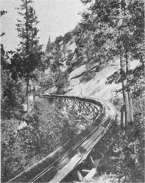
[click to enlarge]
Great Flume of the Madera Flume and
Trading Company—abandoned in 1932
| Online Library: | Title | Author | California | Geology | History | Indians | Muir | Mountaineering | Nature | Management |
Yosemite > Library > Auto Tour > Interesting Points Between Fresno and Yosemite National Park >
Next: Wildlife and Plants • Contents • Previous: Merced to Yosemite
(Total driving distance to park boundary 61.2 miles)
CITY OF FRESNO—This city, the Fresno County seat, with a population of 108,000, because of its central location has become the principal wholesale and retail distribution point in the San Joaquin Valley. Today it is hard to believe that in 1872 a subsidiary of the Central Pacific Railroad which staked out the town in the heart of the San Joaquin desert could find no buyers for its “choice” lots. In this desolation where there was no railroad, town, water, or settlement, the company permitted any newcomers to settle on the lots provided they would purchase them should they decide to remain. Land values unexpectedly increased. In July 1874 when the railroad reached this point there were 29 business and 25 private dwellings. The coming of the railroad encouraged people to move down from the foothills and the county seat, together with the entire population. and many of its buildings, moved from Millerton that year. Fresno means “ash tree” in Spanish. In 1806 Lt. Moraga named a “rivulet from the Sierra” San Joaquin in respect to the parent of Mary, the mother of Christ, and subsequently the name became associated with the southern central valley of California.
COUNTY OF FRESNO— Fresno County was formed in 1856 out of the then huge Mariposa County with Millerton on the San Joaquin River the first county seat from 1856 to 1874. Fresno County embraces 3,830,400 acres and has an average farm production of about $350,000,000 annually as of 1954. Principal crops of the county are dairy products, livestock, poultry, turkeys, cotton, raisins and grapes, figs, paeches, alfalfa and grain.
(From Hotel Californian approx. 8 miles)
FRIANT DAM AND MILLERTON LAKE—The road branching off from Highway 41 at Pinedale leads to Friant Dam on the San Joaquin River. Millerton Lake, formed behind this dam, received its name from the town of Millerton which, along with the site of old Fort Miller (1851-1863), was inundated with the formation of the reservoir. About one-half of Friant Dam and Millerton Lake lies each in Fresno and Madera Counties. Millerton Lake, a local water sports area, is administered by the National Park Service as a National Recreation Area.
(2.3 miles)
MADERA COUNTY— The second youngest county in the State of California, Madera County was formed from a portion of Fresno County in 1893. Its name is from the town of Madera, the county seat, a Spanish word meaning “lumber,” adopted because of the thriving lumber industry there. Madera was the western terminus of the lumber flume which stretched some 65 miles from the Sierra (described under Old Lumbering Operations below). Madera County is divided about equally in plains, foothills and high mountain country, the latter including a part of Yosemite National Park and all of the Devils Postpile National Monument on the east of the range. Its crops are much the same as those of Fresno County with dairying, vineyarding and poultry raising the largest industries. Recreation is an important industry in the mountains.
(7.3 miles)
MADERA CANAL—This canal is a part of the huge Central Valley irrigation project developed by the Bureau of Reclamation. It operates from Shasta Dam in northern California through the great Central Valley to the southern part of the San Joaquin Valley, carrying much-needed irrigation water to the thirsty farm lands of this part of California.
(2.3 miles)
JUNCTION HIGHWAY 145 AND 41—From this point on, Highway 41 is known as the “Yosemite Discovery Road.” On nearby Table Mountain stands a 33’-high cross erected by public-spirited citizens of Madera County in connection with Easter sunrise services.
|
[click to enlarge] Great Flume of the Madera Flume and Trading Company—abandoned in 1932 |
(2.0 miles)
SAN JOAQUIN EXPERIMENTAL RANGE—Beyond the junction of Highway 145 and 41 is the 5000-acre San Joaquin Experimental Range operated by the U. S. Department of Agriculture. and the University of California. Range and cattle improvements are the primary purposes of the station. The U. S. Forest Service has developed grasses here which increase range capacities. The University of California Department of Animal Hushandy studies hereditary characteristics and herd improvement.
CHUCKCHANSI INDIANS— The area around Coarsegold was settled originally by the Chuckchansi Indians. As white men came into the area Chief Black Hawk was instrumental in keeping the tribe friendly. After several years the Chuckchansi tribe became docile and lazy, and the Indian women would marry white settlers to be assured of food. This was a help to settlers who wanted women willing to “rough it,” and who would do without conveniences. Black Hawk Mountain, which is the butte to the right of the road, is named after the Chuckchansi Chief.
(15.5 miles)
CALIFORNIA DIVISION OF FORESTRY—The State Division of Forestry has a headquarters near Coarsegold. Its main purpose is fire control to save grazing lands and stop soil erosion. This headquarters is unique because it is operated under the joint control of the Division of Forestry and the California Youth Authority. Approximately 120 men 18-23 years in age are sent from various institutions throughout the state to this “honor camp” for rehabilitation. From here they assist in fire control and man fire lookouts in the area approximately 100 mile radius in coopereration with the U. S. Forest Service and the National Park Service.
(1 mile)
COARSEGOLD— The gold rush of 1849 brought many prospectors to this area. The town was named for the type of gold found here. By 1850 the community boasted 10,000 inhabitants. One nugget found by two Texas brothers was worth $15,000. It is reported that $18,000,000 in gold was taken from here in a four-month period. By 1866 the nuggets had become scarce and the white men moved on but the patient Chinese came in, some to make fortunes in gold dust. By 1880 the finds were over but the town was established.
GENERAL BOX COMPANY SAWMILL—As you enter Oakhurst you will see the sawmill owned and operated by the General Box Company, a subsidiary of the American Box and Lumber Company. Here is produced lumber from trees taken within a 30-mile radius. The better lumber is dried and sold as building lumber while the poor part of the tree is made into “shook,” the material used for making fruit boxes. This sawmill produces about 12 million board feet of lumber annually.
(7.5 miles from Coarsegold)
OAKHURST—This little community in the mountains near the head of the Fresno River was originally known as Fresno Flats. In 1882 it was reported to be a thriving camp with farming, mining, lumbering and- stock raising as principal industries. At that time discovery of a quartz mine seemed to give promise of local prosperity. Apparently little came of it and an undesirable element moved gradually into Fresno Flat and brought it ill-repute. Wishing to do away with this unfavorable past, citizens about 1914 changed the name to Oakhurst.
OLD LUMBER OPERATIONS—In 1874 the California Lumber Company operated in the Oakhurst area. Railroads were built to get logs to the sawmill but the problem of getting the lumber from the mill to the San Joaquin Valley was great. As a result the 65-mile Madera flume was built and the City of Madera was founded at the flume terminal in the San Joaquin Valley. The Madera Sugar Pine Company purchased the operation in 1900 and continued in business until 1932 when the low price of lumber made it necessary to abandon the project.
(5.4 miles)
SIERRA NATIONAL FOREST— Read description on page 106.
(5.7 miles)
WESTFALL RANGER STATION— Westfall Ranger Station in Sierra National Forest is operated by the Forest Service of the U. S. Department of Agriculture. Its main purpose is fire and insect control and timber improvement. A laboratory of the U. S. Bureau of Entomology and Plant Quarantine is also located here to study effects and control, of forest insects. The suppression of forest fires in this area of well over one million acres is a cooperative project between the State of California, the U. S. Forest Service, and the National Park Service. The station was originally Miami Ranger Station but was changed about 1940 to Westfall in honor of one of the first forest ranger in this area.
(4.2 miles)
YOSEMITE NATIONAL PARK— From this point follow the guide for the Wawona Road (in reverse) on page 82, or, turning to the right at the Entrance Station (0.8 miles from park boundary), use the guide for Mariposa Grove of Giant Sequoias on page 83.
Next: Wildlife and Plants • Contents • Previous: Merced to Yosemite
| Online Library: | Title | Author | California | Geology | History | Indians | Muir | Mountaineering | Nature | Management |
http://www.yosemite.ca.us/library/auto_tour/fresno.html