[click to enlarge]
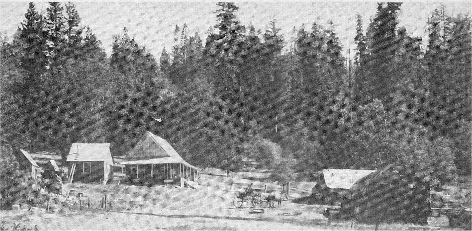
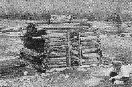
Former Gobin’s Hotel, building on left with porch, and Hurst’s Saloon, shake-roof beyond team. Road from lower left is the Old Big Oak Flat Road with the Coulterville Road cut-off running off lower right.
| Online Library: | Title | Author | California | Geology | History | Indians | Muir | Mountaineering | Nature | Management |
Yosemite > Library > Auto Tour > Crane Flat to Tioga Pass (“T”) >
Next: Merced to Yosemite • Contents • Previous: Big Oak Flat Road (“C”)
(Total driving distance 48 miles)
T-0 THE TIOGA ROAD. This road climbs about 48 miles up the western slope of the Sierra, becoming the highest highway in California at Tioga Pass, elevation almost 10,000 feet. For the first 3.4 miles it follows generally the old Big Oak Flat Road which it crosses at right angles at Gin Flat. Twenty-one miles of the Tioga Road, located approximately in the middle, is the old steep, winding, narrow road built in 1883 by the Great Sierra Consolidated Silver Company. Although improved today this road still retains much of it’s old character and charm. Slow and careful driving along this section is safe. The improved road on either side of the 21-mile stretch was completed in 1938. Negotiations are under way for a new section to replace the old road but portions of the old road will be preserved as an historical exhibit. Along this road you will pass successively through forests of sugar and Jeffery pine, red fir and lodge-pole pine, with the limber-branched western whitebark pine at Tioga Pass. In winter the Tioga Road is closed by snow.
(Additional information under T-7, page 97.)
(0.4 of a mile)
T-1 CRANE FLAT. During the days of the original Big Oak Flat Road, a Mr. Gobin operated a hotel and Mr. Hurst a saloon here at Crane Flat. Very little was known about these operations but diaries of early day travelers mention them. The hotel was built on the approximate location of the present Blister Rust Control Camp.
(3.0 miles)
T-2 GIN FLAT. Scattered all through the high Sierra are meadows known as flats, since most of the surrounding country was very hilly and steep. Cattle and sheepmen used these as pastures before the park was established. Apparently there was considerable activity at Gin Flat in the summertime while John B. Curtin, once state senator and cattleman, headquartered there. A portion of the ruins of a cabin back from
|
[click to enlarge] Former Gobin’s Hotel, building on left with porch, and Hurst’s Saloon, shake-roof beyond team. Road from lower left is the Old Big Oak Flat Road with the Coulterville Road cut-off running off lower right. |
To the right of Gin Flat is a portion of the original Big Oak Flat Road. It can be traveled about 21/2 miles farther to Tamarack Flat and Tamarack Creek campground, and another 21/2 miles to Cascade Creek. Both of these creeks are stocked with eastern brook trout. If you follow this road another couple of miles you will find the site of Gentry, a former toll station at the head of the grade on the old Big Oak Flat Road.
The roadside from Gin Flat to the White Wolf junction has a fine growth of red fir. In this area you will also notice some evidence of glacial polish.
(3.8 miles)
SOUTH FORK OF TUOLUMNE. The South Fork of the Tuolumne River starts some S miles beyond the place where the road crosses it. It usually dries up in late summer or shortly thereafter.
(1.9 miles)
T-4 SMOKY JACK CAMPGROUND. This beautiful, small, wooded campground bears the nickname of an early sheepman who, prior to the establishment of the park, became known as a character in this region. Smoky Jack, whose real name was John Connel, started with a few sheep which he herded personally until he became sheep-rich. “He lived mostly on beans. In the morning after his bean breakfast he filled his pockets from the pot with dripping beans for luncheon, which he ate in handfuls as he followed the flock. His overalls and boots soon, of course, became thoroughly saturated and instead of wearing thin, wore thicker and stouter and, by sitting down to rest from time to time, parts of all vegetation, leaves, petals, etc., were embedded in them, together with wool fibers, butterfly wings, mica crystals, fragments of nearly everything that part of the world contained—rubbed in, embedded and coarsely stratified, so that these wonderful garments grew to have a rich geological and biological significance . . .” (John Muir)
[click to enlarge] Siesta Lake on Tioga Road (4.5 miles) |
(4.5 miles)
T-5 SIESTA LAKE. This spring-fed little lake encircled by lodgepole pine and red firs is not over 5 feet deep and hence any fish which might be planted in it would be subject to winter-kill. No live fish have been seen in the lake since 1954. The name is unofficial and is probably given because it makes a delightful spot along the Tioga Road for rest or picnic. The road was diverted at this point to avoid despoiling the charm of this lake. The rare Arctic three-toed woodpecker nests here occasionally.
(1.0 miles)
T-6 WHITE WOLF. About 1850 John Meyer, a cattleman, while leading a posse to recover horses stolen by Indians, came upon this lovely Alpine meadow. An Indian encampment, whose chief was White Wolf, had stopped here for a short time. Meyer named the place in honor of the chief. This is near the junction of the new and old Tioga Roads. The White Wolf Lodge is about 1 mile off the main paved road on the old Tioga Road. This popular high Sierra camp, at an elevation of about 8,000 feet, is open from approximately July 1 to September 1.
(0.3 of a mile)
T-7 OLD TIOGA ROAD. Between White Wolf junction and Tuolumne Meadows you drive along a section of the old Tioga Road. Twenty-one miles of this road remains in public use and has been only slightly improved since 1883 when the Great Sierra Consolidated Silver Company built it for an access to their headquarters at Bennettville near Tioga Pass where they were driving the famed Sheepherder Tunnel. It cost over $64,000. This old mining road was purchased by Stephen T. Mather and some friends and presented the National Park Service in 1915. A short distance beyond the junction starts a downgrade of some five miles which drops about 1,300 feet and terminates at Yosemite Creek. The name Tioga comes from the Tioga Mining District which may, in turn, have received its name from Tioga County N. Y. Tioga is an Iroquois Indian name meaning “where it forks.”
[click to enlarge] Old Tioga Road - 1956 |
(2.3 miles)
T-8 LUKENS LAKE TRAIL JUNCTION. This trail, near Dark Hole Meadows, is part of the park’s trail system. Wooden directional signs formerly used along these trails were for some unknown reason often destroyed by bears. The metal trail sign seen a little back from the road to the right is made by cutting with an acetylene torch and is considered “bear proof.”
[click to enlarge] New metal trail signs replacing wooden signs destroyed by bear (2.6 miles) |
(2.6 miles)
T-9 YOSEMITE CREEK. Yosemite Creek is the stream that creates Yosemite Falls. Like many streams in the Sierra, Yosemite Creek dries up in late summer after all snow in its drainage basin has melted. This basin faces the sun so that snow here melts sooner than on the more protected slopes. Because of the granite structure of the country and thin soil coverage, springs are uncommon and contribute little or no water to Yosemite Creek. At this location are a summer ranger station and public campground. The campground, at an elevation of 7,200 feet, accommodates approximately 30 camps, has outdoor tables and benches. A trail follows down the creek 6.3 miles to the top of Yosemite Falls thence into Yosemite Valley.
(0.5 of a mile)
T-10 TOP OF YOSEMITE CREEK GRADE. Leaving the campground you start up the Yosemite Creek grade. Here in a distance of about 2 1/2 miles you climb from 7200 to 8200 feet. This road climbs up the side of a moraine piled up by ancient Yosemite Glacier. Here you will pass through one of the most beautiful groves of quaking aspens in the park. The quaking aspen rarely grow below 5000 feet elevation although it is said to be the most widely distributed tree in the world. The tree has a smooth white or cream colored bark covered with black markings. The leaves are shiny, smooth, roundish, and their characteristic fluttering accounts for the name.
(3.4 miles)
T-11 PORCUPINE FLAT CAMPGROUND. One of the smaller campgrounds is situated in the delightful flat meadow surrounded by a red fir forest through which runs Porcupine Creek. 1.2 miles along the road towards Tuolumne Meadows is the entrance to Porcupine Creek Campground, an old Indian campsite, located downstream from Porcupine Flat. From here a trail leads into Yosemite Valley and to North Dome. Elevation at this place is 8,015 feet.
(4.7 miles)
T-12 SNOW FLAT. Approximately 5 miles beyond Porcupine Camp ground is Snow Flat. A snow survey station is maintained here. Several times each winter National Park Service rangers make trips on skis or snowshoes to take snow measurements in order to determine the amount of moisture which will be available to the Central Valley and Bay Region the following summer. Here at an elevation of 8,710 feet, some of the deepest snow in the park is recorded.
MOUNT HOFFMANN - 10,836 feet high, is seen from this point, rising from the west side of May Lake (out of view). In 18 81 silver was found on Mt. Hoffmann and the Mt. Hoffmann Mining District was organized but soon fizzled out. The mountain was named for
[click to enlarge] Mt. Hoffmann from Snow Flat |
(1.8 miles)
T-13 MAY LAKE JUNCTION. Just beyond Snow Flat is the May Lake junction. A steep but well-used foot trail of about 1.7 miles will take you to the May Lake High-Sierra Camp. Located at about 9,300 feet in elevation, the camp is open from approximately July 1 to September 10. The lake was named for Lucy Mayotta Browne who, in 1870, married Charles Hoffmann of the Whitney Survey.
TENAYA LAKE GRADE—After leaving the May Lake junction you start down the Tenaya Lake grade. Here in about two miles you descend some 600 feet. To your left you will see Cathedral Peak (elevation 10,993 feet), Tenaya Lake (elevation 8,141 feet), and Tenaya Peak (10,700 feet).
(1.4 miles)
T-14 TENAYA LAKE. Tenaya Lake was named in honor of Chief Tenaya of the Yosemite Indians. On the early morning of May 22, 1851, pursuing the Yosemite Indians and, from the vicinity of Tenaya Lake Grade, spotting their camps on the lake, the Mariposa Battalion, under Capt. John Boling, made such a hasty attack clothed mostly in their long red underwear that it gave rise to an Indian story of “red devils.” The capture of the Yosemites was completed
[click to enlarge] Tenaya Lake |
[Editor’s note: Bunnell was not the surgeon for the expedition—dea.]
(2.5 miles)
T-15 GHOST FOREST. This is a forest of lodgepole pines which were killed in insect epidemics. Once every two years in July and August the lodgepole pine needle miner moth lays eggs at the base of the needles. After the larva or worm emerges from a small hole, the needles turn chestnut brown. Soon the needles fall off. Bark beetles attacks often follow needleminer epidemics and kill the trees. Air spraying operations have been carried on recently with a hope of reducing widespread destruction. (You may read more about trees in “Cone-bearing Trees of Yosemite” and “Broad-leaved Trees of Yosemite.”) Off to the right of the road is a smooth rock surface with scattered boulders. These angular boulders were dropped during the recession of the last glacier of the ice age.
(1.7 miles)
T-16 EAST END OF OLD GRADE — MT. CONNESS. For a description of this old grade read T-7. At no other place along the park roads, except near Snow Flat, can the mountain hemlock more easily be seen. It normally prefers northern exposure of 9000 feet or more where snow banks linger. John Muir called the mountain hemlock the most singularly beautiful of all the California conifers. The elegance of this graceful tree-mountaineer is ever refreshing in contrast to the rugged staunchness of its associate trees, the western white pine, lodgepole pine, Sierra juniper and whitebark pine.
MT. CONNESS is the most distant and prominent peak seen as you look straight ahead. On the crest of the Sierra Nevada, 12,556 feet in elevation, this mountain was named for John Conness, Senator from California who, on March 28, 1864, introduced in the U. S. Congress the bill establishing the Yosemite Grant, consisting of Yosemite Valley and the Mariposa Grove of Big Trees.
(1.5 miles)
T-17 FAIRVIEW DOME. This is typical of granite domes in Yosemite and the Sierra. Like other granite throughout the region its form resulted from the cooling of molten “magma” or rock, beneath layers of rock which were formed from sea deposits. The manner in which this molten mass cooled determined the way in which this rock weathers, by exfoliating in “shells — as if removing the layers of an onion.
[click to enlarge] Fairview Dome (0.7 of a mile) |
(0.7 of a mile)
T-18 TUOLUMNE MEADOWS. In this region are the headwaters of the Tuolumne River. From here easy hikes will take you to many beautiful lakes and streams which are typical of the grandeur of the Sierra. A store, fountain, and
[click to enlarge] Tuolumne Meadows and Cathedral Peak |
(2,5 miles)
T-19 LYELL FORK, TUOLUMNE RIVER. Just beyond the store you will cross the Tuolumne River which begins at Mt. Lyell Glacier on the extreme eastern boundary of the park. This ice body, roughly one mile wide and one-half mile broad, is the largest glacier within the park. Mt. Lyell, 13,090 feet in elevation and the highest peak in the park, was named for Sir Charles Lyell, a leading geologist of the past century.
(0.1 of a mile)
T-20 LEMBERT DOME—SODA SPRINGS. The lopsided appearance of this dome is the result of glaciers pushing up the slope and forcing chunks of rock off the steep side. The scallops over the face of the dome were worn by sub-glacial streams which followed the courses of these shallow trenches. Patches of glistening glacial polish cover the face of the dome. Ascent of 800 foot Lembert Dome is safe only under expert guidance. It was named for Jean Baptiste Lembert, sheep man and hermit who homesteaded Tuolumne Meadows in 1885. His home was built near the soda springs 1 mile to your left after crossing the Tuolumne River.
TUOLUMNE MEADOW S HIGH SIERRA CAMP. The road to your right after you pass the Tuolumne River bridge leads to the Tuolumne Meadows High Sierra Camp which can
[click to enlarge] Soda Springs, Tuolumne Meadows |
(1.5 miles)
T-21 MORAINE OF ROCKS LEFT BY THE GLACIERS. The roadcut, known as the Blue Slide, exposes here a section of a rounded hill composed of loose rock and fine material left after the front of a glacier melted back. This moraine swings in a great arc toward the peaks to the right (south).
(0.8 of a mile)
T-22 DANA FORK OF THE TUOLUMNE RIVER. Beyond the turn-off road to the Tuolumne High Sierra Camp the main highway follows along the Dana Fork of the Tuolumne River which has its source on Mt. Dana.
(1.0 mile)
T-23 TUOLUMNE PEAK. Looking back down the highway towards Tuolumne Meadows you can see prominent Tuolumne Peak, 10,875 feet in elevation, located a short distance north of the May Lake High Sierra Camp.
(Approx. 0.3 of a mile)
T-24 MAMMOTH PEAK. Looking straight ahead along the road from this point the great rounded form of Mammoth Peak rises to an elevation of 12,225 feet.
(Approx. 0.3 of a mile)
T-25 MT. GIBBS. Named for Wolcott Gibbs, well-known professor of science at Harvard at the turn of the century and life-long friend of Professor Whitney, California State geologist, Mt. Gibbs (seen directly ahead) rises to an elevation of 12,000 feet.
(0.4 of a mile)
T-26 MT. DANA. Mt. Dana can be climbed from Tioga Pass with relative ease. It is not only the second highest peak in the park. elevation 13,053 feet, but it is one of the most colorful. (Inquire of park ranger at the Tioga Pass Entrance Station.) Noted for its beautiful summer wildflower gardens, it was named for James Dana of Yale University, pioneer geologist of the past century. Looking back towards Tuolumne Meadows the skyline, as shown in the sketch opposite identifies Johnson Cockscomb, Unicorn and Cathedral Peaks. As you drive westward towards Tuolumne Meadows you will see these peaks framed strikingly by the road corridor through the forest. Roadside signs will aid you to recognize them.
(2.3 miles)
T-27 TIOGA PEAK. The prominent peak before you is Tioga Peak, elevation 11, 513 feet. Tioga Peak. like Tioga Lake, Tioga Pass, and Tioga Road, comes from an Iroquois Indian name meaning “Where it forks.”
T-28 KUNA CREST. If you look back and to the left from this point within 0.6 of a mile of Tioga Pass Entrance Station you will see a range of peaks known as Kuna Crest at whose northern (right) end stands Mammoth
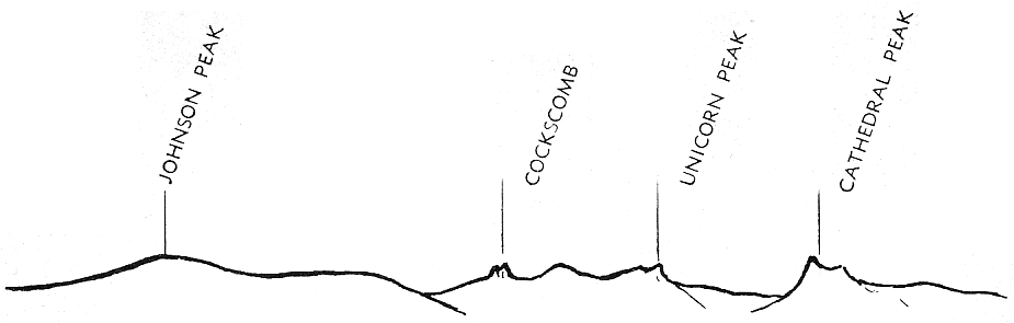
[click to enlarge] Skyline westward from Dana Meadows |
T-29 TIOGA ENTRANCE STATION. Tioga Pass Entrance Station, one of four entrances to Yosemite National Park, is the highest automobile pass in the Sierra and in California, 9741 feet. To your right is the rock formation at the base of Mt. Dana known locally as the “Lion’s Head.” As you leave Yosemite National Park you enter Inyo National Forest. The management of these two areas differ in that in national forests are economic and recreational pursuits such as lumbering, grazing, mining, hunting, and resorts, while in national parks the purpose is “. . . to conserve the scenery, the natural and historical objects, and the wildlife therein . . . and to provide for the enjoyment of the same in such manner and by such means as will leave them unimpaired for the enjoyment of future generations.” Come again!
Next: Merced to Yosemite • Contents • Previous: Big Oak Flat Road (“C”)
| Online Library: | Title | Author | California | Geology | History | Indians | Muir | Mountaineering | Nature | Management |
http://www.yosemite.ca.us/library/auto_tour/tioga_road.html