[click to enlarge]
Sketch 20. Turrets above the Gorge of Despair.
| Online Library: | Title | Author | California | Geology | History | Indians | Muir | Mountaineering | Nature | Management |
Yosemite > Library > Climber’s Guide to the High Sierra > Kings Canyon Region >
Next: Palisades to Kearsarge Pass • Contents • Previous: Palisades
*Assisted by Elwin Covey, David Hammack, and Clinton Kelley.
FOR WILD and rugged grandeur the Kings River Canyon Region of lie Sierra Nevada has no peer. A mighty panorama, beginning at the laundering snow-fed streams, sweeping up the terrifying gorges past jagged spires, and culminating in towering granite peaks and domes presents itself to the adventurer. In this vast, largely unknown area the opportunities for exploration are limitless. With the imposing array of peaks and rock towers, and with many unclimbed summits still awaiting an ascent, the climber can fare very well.
Deepest of all Sierra canyons are those of the Kings River and its two main forks. The great canyon of the Middle Fork of the Kings River is one of the most spectacular parts of the entire Sierra. It is indeed an awe-inspiring sight to break out of the pine forest onto the rim of the Tehipite Valley and gaze across at the opposite mountain wall, fantastically cut up into multiple flying turrets soaring in the blue haze. The thin ribbons of streams, sweeping down the myriads of steep gorges from the high country, line the mountain sides with bands of silver. The great river, four thousand feet below, sends its dull roar echoing about the valley. Here also is the graceful and symmetrical Tehipite Dome, the sentinel of this seldom-visited domain.
To the southwest stands an even greater mountain wall. Spanish Mountain, on the edge of an immense plateau, towers 8,200 feet above the Kings River. The expanse between, dropping off in dizzy contours, is a vast jumble of deep gorges, madly cascading and falling streams, and steeply-tilted spurs, all more vertical than horizontal.
In this section of the Sierra, as well as many of the others, the sheepherders played an important part in early exploration. Perhaps the best known and certainly the most ambitious of this group was Frank Dusy. In 1869 Dusy and Bill Helm set up partnership in sheep raising at Dinkey on Dinkey Creek. On a hunting trip the same year, Dusy shot a grizzly bear near Crown Creek, and followed the wounded bear all the way down to the Middle Kings Canyon. He hiked up to the Tehipite Valley and can presumably be given credit for its discovery. Dusy also built the Dinkey trail to Crown Creek and its extension, the Tunemah trail, to the upper Middle Fork Canyon, both of which were needed to get his sheep to Simpson Meadow.
Around 1876 there was a Hydrographic Reconnaissance of the same area. Among other things, the height of Tehipite Dome was estimated.
Known primarily for his early mountaineering in the Kings Canyon area was Prof. Bolton C. Brown. Among his many achievements were first ascents, in 1895, of Mt. Woodworth and Avalanche Peak and his extensive work in exploration and route finding.
Until recent years, very little climbing has been done here. Some of the peaks above the canyon walls were climbed in past years by hikers or members of the USGS, but the more difficult peaks and the rock climbs remained untouched. In 1935 an attempt was made on the Sphinx, but it was not until 1940 that it was finally conquered. In the years that followed many of the difficult rock towers fell to Sierra Club climbing parties. First was the Obelisk in 1947, and then the towers of the Grand Dike, Gorge of Despair, and Silver Spur in 1951 and 1952. A reconnaissance party in late 1952 returned with the information that there are even more great rock towers to be ascended, which leaves the climbing in this region with a very hopeful future.
The canyons of the Kings River owe their astounding depth mainly to streamwork, although they have been remodeled and enlarged by intense glaciation. Often compared with Yosemite, the Kings Canyon is actually different in most respects. While Yosemite has its hanging valleys and great water falls, nearly all the tributary streams in Kings Canyon have cut their valleys down to so great a depth that they now descend in broken cascades engulfed in slot-like gorges, dark and narrow. The walls are further scored by great avalanche chutes. In the canyon of the Middle Fork of the Kings River, particularly on the southern wall above Tehipite Valley, the actions of streams, glaciers and the elements through countless centuries have left in their wake many fantastic spires and towers. It may be safely said that these are the finest rock climbs in the entire Sierra, outside of Yosemite Valley. The fact that they lie in lonely, barely accessible country only adds to their enchantment.
The great canyon of the South Fork also has attractions for the mountaineer. The best climbing is undoubtedly on the Grand Dike, an immense steep and broken ridge comprised of eight large towers and a number of minor summits. Farther up this canyon may be found the Grand Sentinel and the Sphinx, also fine climbs, which are easily reached from roads end.
In general, the rock in this region is fairly sound granite, but that of a crumbling nature is occasionally encountered. Many of the rocks have peculiar knobs protruding from their surface shells, a remarkable characteristic seldom found elsewhere. These knobs can be found on the towers above the Gorge of Despair, where they enable one to climb high-angle walls, and on the Obelisk, where they are sound enough to safely hold a rappel rope.
From the north. A trail leaves the John Muir Trail at the mouth of Palisade Creek (8,125) and follows down the Middle Fork of the Kings River to Simpson Meadow. Here the trail divides, one branch continuing down the Middle Kings to Tehipite Valley, the other branch rising to Dougherty Meadow, and still upward to cross the Monarch Divide at Granite Pass (10,677), then dropping down to meet the Kings River Canyon at the old Kanawyers campsite.
From the south. Starting from Giant Forest in Sequoia National Park, the most direct route is over J. O. Pass (9,410) to Rowell Meadow, where two branching trails lead to the same route. One joins at Horse Corral Meadow and the other goes over Marvin Pass (9,100) to join between Horse Corral Meadow and Summit Meadow. The trail descends by switchbacks to the floor of Kings River Canyon at Cedar Grove (4,631).
From the east. Leaving the John Muir Trail at the forks of Woods Creek, a trail goes down the creek to its intersection with the South Fork of the Kings River. After fording the river, the trail follows down the west bank through Paradise Valley to a junction with the Kings River Canyon trail. Farther south on the Muir Trail, the Bubbs Creek trail leads westward to the Kings River Canyon.
From the west. Highway 180 from Fresno leads first to General Grant Grove, then continues to Cedar Grove. From here all points of the Kings Canyon area are accessible with the exception of the Tehipite Valley and peaks on the north wall of the Middle Fork. A long trail from Cliff Camp on the North Fork of the Kings River passes through Three Springs, Collins Meadow, and finally drops into the Tehipite Valley, from which Simpson Meadow may be reached. At Collins Meadow an alternate trail branches eastward over Tunemah Pass (10,879), and descends a steep and unsafe route to Simpson Meadow.
The Tehipite Valley may be reached from Cedar Grove by crossing the Monarch Divide at Happy Gap and following down the east bank of Silver Creek. This is a dangerous route, unfit for pack animals, and is further complicated by the fact that it is often impossible to cross the Middle Fork of the Kings in the valley. In the spring, at high water, this river may present an impassable barrier at many points, as the only bridge is a suspension bridge at Simpson Meadow.
The rock climbs on the great spurs above Tehipite Valley are not easily approached from any direction. The only feasible route is to start from the South Fork of the Kings River, following up either the Lewis Creek or Deer Cove trails to Wildman Meadow. Just west of this meadow is Grizzly Creek, which can be followed along its west bank to the top of the Monarch Divide. The divide is crossed at a saddle just west of Hogback Peak. Care must be taken at this point to descend into the correct canyon. A route due north would continue past Swamp Lakes and then down into Lost Canyon, which is virtually unexplored. A one-half mile traverse to the west must be made from the saddle to enter the upper end of the Gorge of Despair. This gorge can be followed down; keeping on the north side of the Creek, until a suitable base campsite can be found at about 8,000 feet elevation. Many fine rock climbs are available from this point.
Because of the three thousand foot precipice at the lower end, it is impossible to enter the Gorge of Despair from the Tehipite Valley. Those exploring the other great spurs and canyons in this area will find that the obstacles to cross-country traveling are often great, and sometimes insurmountable. Because of this fact, there are many rock towers that have never been closely approached, some of which may well prove to be more than worth the arduous trip to their base.
Most of the meadows in this region provide excellent campsites, having water available all year. Especially to be recommended because of their beautiful setting are Collins Meadow in the Crown Valley, Simpson Meadow on the Middle Fork of the Kings River, and Zumwalt Meadows in the Kings River Canyon. Pasturage is good in general, but is very meager on portions of the Granite Pass Trail, especially between the pass and Granite Basin. The floor of Tehipite Valley is also quite barren, except in early spring. Not shown on the USGS quadrangle map are several meadows about one-third mile northwest of the Obelisk, which are the best campsites in that vicinity.
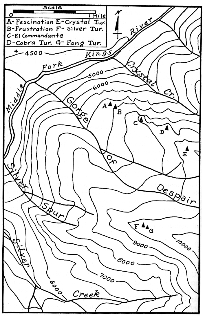
A good base camp can be established alongside the creek in the Gorge of Despair at an elevation of approximately 8,000 feet, which is near the base of Cobra Turret, and close to the best climbs in the region.
The peaks covered in this section of the Guide lie in an area partially within the borders of Kings Canyon National Park and partially in the Sierra and Sequoia National Forests. This region extends from Mt. Woodworth on the north to Sentinel Dome on the south. The western boundary follows from Finger Peak south along Kettle Ridge to the Obelisk, and jogs over to include Spanish Mountain. The eastern boundary, starting at the intersection of Goddard Creek with the Middle Fork of the Kings River, follows down the Middle Fork to the Granite Pass trail near Simpson Meadow. This trail serves as the easterly limits of the arbitrary region from here on south. Avalanche Peak and The Sphinx are also included in this section.
Because they are widely scattered, the peaks and rock climbs in the Kings Canyon area cannot be grouped in any strict order. Therefore, they are arranged in order from west to east as follows:
Peaks north and west of the Monarch Divide
Peaks of the Monarch Divide
Peaks south and east of the Monarch Divide
There is, however, an exception to the above rule. On spurs having a number of rock towers on them, the towers are grouped according to elevation, from the lowest to the highest. The spurs themselves will follow the original west to east classification.
Spanish Mountain (B.M. 10,044; 10,051n)
Climbed in 1921 by Hermann F. Ulrichs. May be climbed from the northwest by a number of routes, but the most interesting route lies along the southeast ridge, where the best view of the 8,000 foot deep canyon can be had. Class 2.
Obelisk (9,707; 9,700n)
Route 1. Class 5. First ascent in 1948 by Jim Wilson and Allen Steck. The route starts up a long, well broken chimney on the south face. The chimney ends at the foot of a steep wall about 100 feet high. This pitch is the crux of the climb, for it is quite exposed and the holds are unreliable. Several pitons are used here for safety. The lead is about 100 feet with no intermediate belay spots. The route to the summit is easy from the top of the wall. Six rappels are required to reach the ground. Length of climb: 500 to 600 feet.
Route 2. Extreme class 4. First ascent June 1951 by Anton Nelson, David Hammack, John Salathé, and Alice Ann Dayton. The climb starts on the short 45° ridge near the center of the north face. The slabs are ascended for about 100 feet, at which point the ridge ends. A traverse to the right (west) is made around the face on very small, exposed ledges to the west arête. The arête is followed to the summit on excellent holds. Time required: 1 1/2 hours.
The rope-down, if made from the northeast shoulder over the great overhang, involves a 130 foot rappel. Some of the large knobs that protrude from the surface of this rock make excellent anchor points. Care should be taken to see that the rope will run around the knob used.
Kettle Dome (9,452; 9,448n)
First ascent July 20, 1920, by Hermann Ulrichs. Climbing data is meager on this dome as ascents are rare. In the notes of Ulrichs, we find this description: “Only one or two narrow cracks in the smooth rounded granite afford finger holds sufficient to make an ascent possible.” The climb is probably class 3.
Tehipite Dome (7,713; 7,708n)
First known ascent by Allan L. Chickering and Walter A. Starr on July 31, 1896. The summit can be gained by climbing out along a sloping ledge on the west face or by going out the backbone, which involves nothing more than a rock scramble. The easiest way to reach the north base of the dome is to leave the Tunemah trail at the 7,500 foot level and contour around, as severe brush is encountered at higher elevations.
Fascination Turret (7,000; 7,000+n)
Unclimbed. This is the lowest rock tower on this immense spur, being almost out of sight of the larger towers above. It is located on the extreme end of the spur, immediately above the tremendous drop-off into Tehipite Valley. The only possible way to reach it would be to start from the notch connecting Frustration Turret to the wall, and traverse around the base of Frustration on the north side. The base of
|
[click to enlarge] Sketch 20. Turrets above the Gorge of Despair. |
Frustration Turret (7,500; 7,500+n)
First ascent June 18, 1952, by David Hammack, Jules Eichorn, Clinton Kelley, and Bob Smith. The climb starts from just below the notch at the base of the east face, and goes straight up this face for about 100 feet to a small tree ledge, which serves as the first belay point. The holds up to this ledge are very small at the start, but improve farther up. From this ledge continue upward on good holds for another 15 feet to a smaller ledge. Traverse around the face to the right, passing under the huge overhanging slab to a broken shoulder. This is ascended to the large friction ledge above. Cross this outward slanting ledge to the other end and up a semi-chimney. By going upward and to the right, a large steep slab on the northwest corner of the tower is ascended. The route follows up the vertical jam-crack from the slab, and then up to the right to a small platform. Several variations of the route can be made here. By going up to the left, a class 5 route on small holds can be followed. The other choice is to work slightly to the right (W) and up a highly-polished trough at the limit of friction. At the upper end of the trough a traverse is made to the left. Either route brings one to a narrow ledge under a vertical face about 100 feet below the summit, which can he climbed with one or two pitons for direct aid, and with the aid of a small crack. Continuing slightly to the left, the route goes up a short, steep pitch requiring long arm pulls on hidden holds, and finally brings one out on the northeast shoulder at the summit block. A traverse around the block to the south side of the tower leads to an easy route to the summit. The rope down is made on the north face down to the large friction ledge in two rappels. The first ascent party climbed down from here to the tree ledge on the east face, and then rappelled from there. Time required: 3 hours. Length of climb: 400 feet. Class 6.
El Corporale Turret
First ascent July 25, 1951, by David Hammack and Anton Nelson. The climb is made up the prominent gully, making use of the large solution knobs, and is just difficult enough to justify a rope. Class 4.
El Commandante Turret (8,600; 8,590n)
Route 1. First ascent on July 25, 1951, by David Hammack and Anton Nelson. Class of climb: Extreme class 5. The only apparent route on this tower is the obvious chimney that starts from the south (lower) corner and leads to a large platform about half way up. The climb is started by ascending the chimney for about 30 feet until it begins to steepen, and then out on to the southwest face, where use is made of the large solution knobs. The chimney is intersected again at the platform. From the platform, which is at the northwest corner, a class 5 route zig-zags up the 70° face to a point just below the summit block. Here a delicate friction pitch, either up a steep arête or across the face to the southwest corner leads to a point from which the summit may be attained. Time required: 3 hours. Length of climb: 300 feet.
Route 2. First ascent on July 19, 1952, by a Sierra Club party of nine. Class 5. The climb starts in the same chimney as Route 1, but instead of going out on to the face, the chimney is followed up until it ends. Here a short traverse is made to the right (NE) which leads to the platform. From this point the deep chimney is climbed until it also ends. The route traverses slightly to the right, and then up a high angle class 5 crack to the easy summit pitch.
Cobra Turret (9,100; 9,050+n)
First ascent July 26, 1951, by David Hammack and Anton Nelson. The highest point on the northwest side is reached by skirting the cliffs. This point, from which the climb is started, is just to the southwest of the ridge above Crystal Creek. A large tree may be seen about 75 feet above the ground on the face of the turret, and may be reached by a 3rd class scramble. From the tree, the route leads to the southwest for about 50 feet, and then up and back into a semi-chimney, passing the overhang to the right (SW), and continuing to a suitable belay spot. This lead is a full 120 feet, and requires the use of several class 5 pitons. From here, the climbing continues directly up by a number of possible routes. Solution knobs allow one to ascend the vertical face in several spots. It would seem best, however, to remain just above the prominent semi-chimney. Approximate time: 21/2 hours. Length of climb: 500 feet. Class 5.
Crystal Turret (9,600; 9,500+n)
The highest rock tower in this group. First ascent July 25, 1951, by David Hammack and Anton Nelson. This climb is started from the southeast corner. A “window” may be seen from this side through which the route passes. Beyond the window, the climb is simply that of mounting a short arête to a large platform, and then traversing around the south side of the summit block to a point where it can be easily climbed. Time required: 45 minutes. Length of climb, 200 feet. Class of climb: Extreme class 4.
Towers on Silver SpurSilver Turret (9,914; 9,991n). This is the most prominent feature on Silver Spur, and is shown on the USGS quadrangle map (elevation). The summit is reached by a 3rd class scramble from the south. First ascent by David Hammack and Anton Nelson on July 27, 1951.
Fang Turret. A very difficult 100 foot rock spire immediately to the south of Silver Turret. From the southeast notch, the route is easily seen. Pitons for direct aid and safety are required on the almost vertical route. First climbed on July 27, 1951, by David Hammack and Anton Nelson. Approximate time: 1 hour. Class 6.
(Below and to the east of Silver Turret is another large rock mass, as yet unclimbed, which promises to provide an interesting climb.)
Finger Peak (12,401; B.M. 12,404n)
First ascent by government surveying party. Records of the route used are not available, nor is the date of ascent.
Burnt Mountain (10,602; 10,608n)
Probably climbed by early exploring parties. There appear to be no climbing difficulties ‘to surmount this peak, and it is easily approached from the Tunemah trail.
Blue Canyon Peak (11,838; 11,849n)
There is no recorded ascent of this peak.
Tunemah Peak (11,873; 11,894n)
No recorded ascents, but may have been climbed by an early party or by sheepherders.
Slide Peak (11,007; 10,9150)
Unclimbed. The north and west faces of this peak are very steep mid would no doubt provide some interesting class 4 routes. An ascent from the south could be done class 3, however. From any direction, it would be a rewarding climb.
Wren Peak (9,449; 9,450n)
No recorded ascents. This is a group of formidable-looking crags at the upper end of Junction Ridge. Several of the rock towers in the group may prove to be difficult climbs. The best approach would be from Happy Gap.
Eagle Peaks (9,800; 9,750+n)
While there are no records of ascents in this group of peaks, some of them may have been climbed by exploring parties. All of them appear to be rock scrambles from their bases.
Mount Harrington (11,001; 11,005n)
First recorded ascent July 27, 1951, by David Hammack and Anton Nelson. The best approach to the base is from the north. The lower part of the mountain presents no serious climbing difficulties. The jagged summit spire is a climb of extreme class 3 difficulty, with large holds all the way up.
Hogback Peak (11,164)
This great heap of huge talus blocks on the crest of the Monarch Divide has probably never been climbed, for obvious reasons. An ascent would involve hours of drudgery for rather dubious rewards. Anyone wishing to climb it, however, would find the best starting place to be the saddle just to the west.
Kennedy Mountain (BM. 11,424; 11,433n)
First ascent by government surveying party. This peak appears to be a class 2 ascent from any direction except the north, where the face drops a sheer 600 feet.
The Grand Dike (7,500 to 8,500)
A traverse of seven of the eight towers was made on July 28, 1951, by David Hammack and Anton Nelson, which constituted first ascents of all but tower number 4. The towers are numbered starting from the lower (SE) end. Below the first tower there is a minor unclimbed pinnacle.
Tower No. 1. The route leads up the eastern face of Tower No. 2 for about 70 feet to a broad, horizontal ledge. (A diagonal upward ledge from low down on Tower No. 2 is not the route.) The broad ledge leads to the notch between No. 1 and No. 2. From the notch, Tower No. 1 is easily climbed by circling around to the west face. Class 4.
Tower No. 2. This is the truncated, small tower between the larger towers No. 1 and No. 3. From the broad ledge mentioned above, a short chimney continues up the east face to the summit. Class 4.
Tower No. 3. From the notch between Nos. 2 and 3 a traverse is made around the southeast face. After it becomes impossible to traverse easily any further, the route goes up and back to the right (SE) on a high angle face with good holds, to a large ledge. The next lead bears to the left (NW) and follows, in general, the northwest corner. This brings one to the base of the main pitch of the climb, a 70 degree face with few prominent holds. This pitch should be done by working slightly to the right (S) and up until a cornice is reached that supplies a few underholds. From the top of this pitch the summit is easily reached. Approximately 2 hours to climb. Length of climb: 300 feet. Class 5.
Tower No. 4. First ascent June 15, 1952, by David Hammack, Bob Smith, George Larimore and Bob Purington. The route starts in a large chimney on the northeast side. The chimney is ascended about 30 feet, or until it is possible to work out to the right on small holds onto the fate. The route follows up a short distance to a suitable belay point on one of the small ledges. A piton anchor should be used here by the belayer. From here the ascent continues up the northeast face at high angle on good holds, and up a tight chimney to a small but conspicuous tree ledge, the next belay point. Continuing straight upward and then traversing slightly to the left, a large, partially detached flake is reached. The broken edges of the flake make a ladder enabling one to ascend the vertical face quite easily. The face is climbed until the great north shoulder is reached. This is the next belay point. From here, a short class 3 pitch leads to the summit. The best method of descent is to climb down to the shoulder and rappel down the northwest side into the notch between Nos. 4 and 5. Adequate rope must be carried, as this is a 120 foot rappel. Time required: 2 hours. Length of climb: 350 feet. Class 5.
Tower No. 5. From the notch between Nos. 4 and 5, the summit may be attained by climbing up the broken southeast face. There is only one spot that offers any difficulty, and that is a short, slightly overhanging wall that must be climbed to get out of an alcove about half-way up. From there the main arête is more or less followed to the summit. It appears as though there is an easier route leading up the north face, but it has not been investigated. The rope-down is to the notch between Nos. 5 and 6. Class 3 to 4.
Tower No. 6. From the notch between Nos. 5 and 6, there is only one obstacle on the entire climb and that is the to foot overhanging wall that extends along the base immediately beside the notch. This is overcome by climbing a small tree about 30 feet below the notch (W side) and traversing across to the wall. The rest of the climb is 2nd and 3rd class.
Towers No. 7 and No. 8. May be climbed by any number of routes, none of which offer any serious difficulties. Each of these summits may be attained by 2nd and 3rd class routes.
Lookout Peak (8,547; 8,501n)
First ascent by Elisha Cotton Winchell on Sept. 27, 1868. The climb is described as an easy scramble from Summit Meadow. It is probably no more difficult than class 2.
Stag Dome (7,707; 7,704n)
Records of first ascent are not available, but there is now a USFS lookout station on the summit.
Sentinel Dome (9,127; 9,024n)
This peak is climbed often by hikers to obtain a view of the high country. Information of the first ascent is not obtainable.
Comb Spur (11,617; 11,618n)
A traverse was made of this spur from July 11 to 25, 1931, by Robert A. Owen.
North Mountain (8,642; 8,629n)
No recorded ascents.
Mount Hutchings (10,787; 10,785n)
No recorded ascents.
North Dome (8,657; 8,720+n)
First ascent June 30, 1940, by Neil Ruge and Florence Rata via Granite Creek and Copper Canyon.
Avalanche Peak (10,085; 10,000+n)
First ascent in July 1895 by Prof. Bolton C. Brown and A. B. Clark. From the description of the ascent by Brown, it was just a stiff hike to the summit from the outlet of Copper Creek.
Grand Sentinel (8,514; 8,464n)
First ascent in 1886 by J. N. LeConte, Helen M. Gompertz, Mr. and Mrs. W. S. Gould and party. This ascent was from the back (S) and did not involve any difficult climbing.
An interesting rock climber’s route is that used by Roy Gorin and Jerry Ganapole on July 7, 1951. Two major steps can be seen in the outline of the Grand Sentinel from the canyon floor at Zumwalt Meadows. The base of these steps is approached by working up the stream bed immediately to the west. The lower of the two rock faces can be climbed on the edge of the buttress overlooking the 90 degree north face, with class 4 and one or two easy class 5 pitches. A walk across the wide shelf leads to the base of the upper face. From here several moderately difficult class 5 pitches lead to the summit. Climbing time from the base of the lower face is 4 hours. Total time to reach the summit from the canyon floor is to hours.
The Sphinx (9,122; 9,039n)
First ascent July 26, 1940, by Art Argiewicz and Bob Jacobs. The Sphinx is the farthest north and slightly lower of the two points comprising the mass. In order to reach the top it is necessary to climb over the higher point, down the north face about 300 feet and up to the notch between the two. The key pitch is a 200 foot face, triangular and almost devoid of holds. Above this is the 150 foot summit ridge. A delicate traverse is made across the face to the south wall, where a small ledge can be found around the corner. From here an open chimney leads to the top of the ridge and the summit. Class 4.
References
SCB, 1896, 241, 295; 1897, 44, 79, 106; 1907, 115; 1922, 313; 1935, 66; 1941, 127, 131; 1948, 121.
Photographs: SCB, year and page or plate number as shown: Gorge of Despair and El Commandante: 1898, pl. 8. Middle Fork Kings Canyon: 1908, pl. 8; 1921, pl. 55. Simpson Meadow: 1907, pl. 30; 1911, pl. 19; 1917, pl. 180; 1921, pl. 45. South Fork Kings Canyon: 1907, pl. 20; 1914, pl. 65. Tehipite Dome: 1897, P. 44; 1898, pl. 7; 1907, pl. 28; 1913, pl. 28; 1914, frontispiece; 1914, p1. 57; 1921, pl. 58; 1935, p. 63; 1944, p. 46. Tehipite Valley: 1913, pl. 9, 28, 32, and 48.
Next: Palisades to Kearsarge Pass • Contents • Previous: Palisades
| Online Library: | Title | Author | California | Geology | History | Indians | Muir | Mountaineering | Nature | Management |
http://www.yosemite.ca.us/library/climbers_guide/kings_canyon.html