
[click to enlarge]
[click to enlarge]
All photographs in this issue by Ralph Anderson except as otherwise indicated.
| Online Library: | Title | Author | California | Geology | History | Indians | Muir | Mountaineering | Nature | Management |
Yosemite > Library > Devil Postpile National Monument >

[click to enlarge] |

[click to enlarge] All photographs in this issue by Ralph Anderson except as otherwise indicated. |
THE MONTHLY PUBLICATION OF
THE YOSEMITE NATURALIST DIVISION AND
THE YOSEMITE NATURAL HISTORY ASSOCIATION, INC.
| C. P. Russell, Superintendent | D. E. McHenry, Park Naturalist |
| D. H. Hubbard, Assoc. Park Naturalist | N. B. Herkenham, Asst. Park Naturalist |
| W. W. Bryant, Junior Park Naturalist | |
| VOL. XXXXI | OCTOBER, 1952 | NO. 10
|
|
|
By Richard J. Hartesveldt, Ranger Naturalist,
Devil Postpile National Monument
The administration of Devil Postpile National Monument has changed back and forth between the U. S. Forest Service and the National Park Service for many years. When Yosemite National Park was established in 1890, its boundaries then included the Devil Postpile area. But in 1905, mining, water, and grazing interests succeeded in getting Congress to withdraw from park status more than 500 square miles of the western and southeastern portions of Yosemite National Park. This land, containing the small postpile area, was thus returned to national forest status and could thereby be exploited.
In 1910, water interests were planning to dam up the Middle Fork of the San Joaquin River and inundate the Devil Postpile, then still called Devil’s Postpile. The Sierra Club, as well as other conservation organizations, became alarmed at the prospect of having this interesting geological phenomenon destroyed. The club’s board of directors, among whom were John Muir, J. N. LeConte, and E. T. Parsons, wrote letters to the President of the United States and to the Secretaries of Agriculture and the Interior, urging that the President save the postpile by setting it aside as a national monument. Acting upon these recommendations, and authorized by the Act for the Preservation of American Antiquities, of 1906, President Howard Taft proclaimed the area Devil Postpile National Monument on July 6, 1911. As far as can be determined, it was at this time that the “’s” was dropped from the word Devil’s, perhaps as a clerical error, and the official name became Devil Postpile. While this remains the accepted designation, most people call it Devil’s Postpile,
The national monument was at first administered by the U. S. Forest Service whose land surrounded it. It was but little visited until the first road was built into the valley of the middle fork for mining purposes. Even then the administrative duties were light because the very poor quality of the road was not inviting enough to bring many motorists down to the postpile. On August 10, 1933, after a rearrangement in the U. S. Department of the Interior, the jurisdiction of Devil Postpile National Monument was given to the National Park Service. Then on March 24, 1934, the superintendent of Yosemite National Park was made responsible for its protection and supervision.
From that year until World War II, a ranger was stationed each summer at Soda Springs Meadow, a quarter of a mile from the postpile. Lack of sufficient funds during the war made administration from Yosemite Valley, 126 driving miles distant, impractical. Through a temporary cooperative arrangement with the U. S. Forest Service, the national monument was again put under its supervision for protection. During one summer, soon after the war, a park ranger from Yosemite was stationed there, but it was not until 1952 that another agreement was made, returning the supervision of Devil Postpile National Monument again to Yosemite National Park. In the summer of 1952 an organized interpretive program was initiated, consisting of evening campfire programs and trailside contacts at the postpile. The program met with condorable popularity.
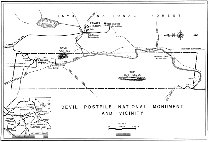
Today, the boundaries of the monument are the same as they were when it was established. The postpile is located in the valley of the Middle Fork of the San Joaquin River, about 29 miles east of Yosemite Valley, and just west of the Sierran crest. The monument is 2 1/2 miles long and half a mile wide, making a total area of 1 1/4 square miles. The elevation varies between 7,100 feet and 7,800 feet.
|
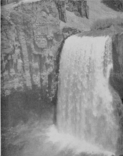
Rainbow Fall, height 140 feet, on Middle Fork of San Joaquin River, Devil Postpile National
monument. The columnar structure for which the postpile is renowned appears also in the basaltic cliff alongside the waterfall. |
| Ted Cronyn |
| [click to enlarge] |
|
By Richard J. Hartesveldt, Ranger Naturalist,
Devil Postpile National Monument
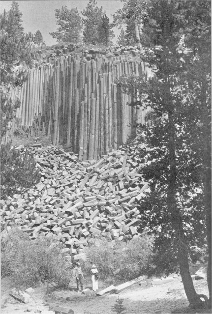
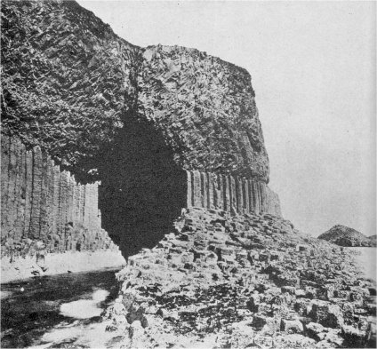
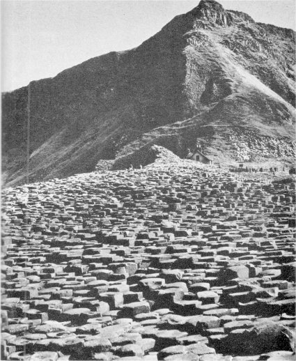
California’s Devil Postpile represents one of the best examples of columnar basalt exposed on the surface of the earth. Other well-known examples are the Giant’s Causeway in Ireland and Fingal’s Cave in Scotland, while the Palisades of the Hudson River and the formation at San Miguel Regla, Mexico, are also noteworthy. Areas of occurrence elsewhere include Germany, Tasmania, Oregon, and Arizona, but these have not been widely publicized. The geologic history of the postpile dates back only to the latter part of the Pleistocene epoch, or between one and two hundred thousand years ago. However, a better understanding of this unique area may be had by tracing briefly the history of the Sierra Nevada back to its origin.
Late in the Jurassic period, about 130 million years ago, a system of mountain ranges including the ancestral Sierra Nevada was forming in eastern California and large areas of adjoining states. Elevated from the bottom of at vast inland sea, they were built of deep layers of accumulated sediments, gradually folded
| Fingal’s Cave, Isle of Staffa, off west coast of Scotland. Courtesy British Information Services |
| [click to enlarge] |
|
[click to enlarge] |
| The Giant’s Causeway, Northern Ireland. Courtesy British Travel and Holidays Assoc. |
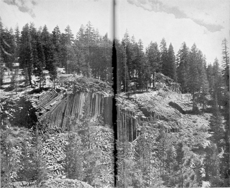
Center pages following: The Devil Postpile. Photo by J. V. Lloyd.
| [click to enlarge] |
|
Commencing about 60 million years ago, in the early part of the Tertiary period which followed the Cretaceous, the region was gently warped upward so that the area which was to become the Sierra Nevada acquired an initial slant toward the southwest. New streams were born as water found a west-facing slope down which to flow. Later in Tertiary time, or about 15 million years ago, a series of major uplifts began which caused the Sierra Nevada to stand out as an enormous block range, by elevating its eastern edge and increasing its tilt toward the west. Its crest was raised to about 7,500 feet above sea level, while the gradients of the new streams were steepened, allowing them to cut deeper into the granite slopes and farther headward toward the crest. Eventually the west-flowing streams captured the older north- and south-flowing ones, diverting their waters to the west into the San Joaquin Valley, then into the Pacific Ocean. The Middle Fork of the San Joaquin River, which flows south through Devil Postpile National Monument, was blocked at an early date from flowing west by the high, steep Ritter Range. The river parallels this range for many miles before it finally is able to turn to the west where it joins the main San Joaquin. It is interesting to note that the part of the Sierra Nevada through which the main stream flows is a “sag” in the range, possibly representing an ancestral broad valley which existed prior to the rise of the Sierra. The San Joaquin River may then have had its headwaters in what is now the State of Nevada.
The last series of major uplifts of the Sierra Nevada, occurring at the beginning of the Pleistocene epoch between one and two million years ago, elevated the crest to its present height of 13,- to 14,000 feet and further steepened the tilt of the western slope. The principal west-flowing streams of the range were thereby greatly accelerated and they ultimately eroded deep canyons. Despite the size of the Middle Fork of the San Joaquin, it was unable to keep pace with the main river in cutting a canyon. The speed of its flow could not be accelerated because it was flowing south, whereas the uplift tilt was to the west. Eventually, after the main river had cut its canyon, the middle fork did cut a deep valley.
The cool, moist climate of the Pleistocene epoch, or ice age wrought great changes in the Sierran topography. Glaciers, nourished by heavy snows on the crest of the range, descended slowly through the old stream-cut canyons, both deepening and widening them. In each of the three glacial stages that are recorded in the Sierra Nevada ice flowed through the San Joaquin’s middle fork valley. It was between the last two stages, from 100,000 to 200,000 years ago, that the Devil Postpile had its origin.
When mountains are formed by the faulting of the earth’s crust, as in the case of the rising Sierran block, the resulting fault is often a passageway for volcanic materials to find an exit to the earth’s surface from below. Volcanics are much in evidence to the east of the Sierra Nevada and they occur in several places west of the eastern front, indicating a fault zone that is complex. Before the glaciers covered the range, volcanics had already built Mammoth Mountain located just east of the Devil Postpile. Immediately to the south of this mountain, which is now much eroded, is Mammoth Pass where a fissure opened in the earth’s crust, spewing forth basaltic lavas that poured down into the middle fork valley. The molten material filled the valley from one side to the other, flowed north to Pumice Flat, and southward to below Rainbow Fall. The depth of the pooled lava on the valley floor varied between 100 and 700 feet. It was of two kinds, each a basalt porphyry, and each homogeneous within its own mass, but the two varying slightly in composition. The columnar basalt of the postpile contains pinhead-size phenocrysts of olivine and elongate tabular crystals of feldspar of a larger size. The ground mass is dense black basalt. The other lava, which in most places overlies the columnar basalt, resembles shale and is called “platy lava.” The phenocrysts in this material are hornblende and occasional grains of quartz.
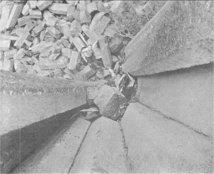
Undoubtedly the lava was very fluid and pooled so quickly that for a while it was molten throughout most of its depth. As it began to cool and solidify, it shrank. Shrinkage in a vertical direction was taken care of by gravity, but in a horizontal direction tensions were created that had to be relieved by cracking of the rock. In a homogeneous mass of molten rock that is cooling evenly, the tensions are most easily relieved when three cracks, making angles of 120° with each other, radiate out from each of numerous centers on the cooling surface. In the Devil Postpile these centers were spaced at intervals of from 1 to 2˝ feet, or slightly more in some places. The fractures all grew laterally until they joined one another, creating polygonal figures. Then as the lava cooled downward, continuing to shrink evenly, the polygonal pattern of cracks was extended downward probably until it had penetrated the full depth of the lava mass. The resuiting columns average about 2 feet in diameter and are 4-, 5-, 6-, or 7-sided. The largest column in the postpile is 3 1/2 feet in diameter. A sample of 200 “posts” shows the following percentages for the various numbers of sides: 4 sides, 2%; 5 sides, 37%; 6 sides, 55 1/2%; 7 sides, 5 1/2%. Some of the columns rise as high as 60 feet.
The axes of the basalt columns should develop approximately at right angles to the cooling surface. Supposing the lava surface to be everywhere level, then, theoretically, all of the resulting columns would be vertical. However, the greater percentage of columns in the Devil Postpile are “tipped” and some of them are “bent.” This phenomenon is not explained in the literature but it seems to indicate irregularites in the cooling surface. If small “hills” of platy or scoriaceous lava were present, acting as insulators, the direction of cooling would occur at an angle away from the vertical, thus forming the columns at an angle. The effect of these “insulators” on cooling may have been modified at greater depths by the molten mass, causing the cracks there to become nearly vertical again, and thereby producing the “bent” effect so prominent at the postpile.
It remained for the last glacier (Wisconsin Stage) flowing through the middle fork valley to expose the sides of the “posts.” The slow-moving body of ice, about 1,000 feet thick, found little difficulty in quarrying away the cracked basalt columns. Nearly all of the lava in the valley was removed by the action of the ice, leaving only small remnants of which the Devil Postpile is the largest. Other lava columns, less spectacular than the postpile itself, are found in several places within or near the monument. Most of these remnants indicate clearly the direction of ice flow by means of the steep downstream, or lee, slopes contrasted with the gentle slopes of the upstream, or stoss, side. Where glaciers can pluck away fractured rock, the plucking action on the lee side is much greater than the pushing or “bulldozing” action on the stoss side. These lee slopes are often so steep as to be precipitous, such as at Rainbow Fall.
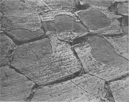
A hike to the top of the postpile reveals the most interesting of the effects of the ice—the polished tops of the rock columns. Here their polygonal ends are exposed like a tiled floor (see photo below), Much of the original polished surface, however, has been weathered away since the retreat of the glacier over 20,000 years ago. Such surfaces exhibit parallel striations or small grooves gouged by pieces of stone as they were dragged over the tops of the columns under the great weight of the overriding ice. One groove, carved in granite near the southwest corner of the monument area, is 3 inches deep, 10 inches wide, and more than 10 feet long.
Erratic boulders, once carried by the ice from points upstream, are deposited in many places within the monument, mostly on the high granite hills and ridges on the west side of the San Joaquin River. That they came from upstream is evident because they are nearly all boulders of metamorphic rock, outcrops of which are not found within the monument boundaries today.
Within postglacial time volcanic activity has again taken place in the Mammoth Lakes area and in several other places on the east side of the Sierra Nevada as far north as the Mono Craters. Great fissures opened
|
Mosaic-like pattern of tops of “posts.” The glacier-polished surface, some of which has weathered
away, bears many parallel grooves showing direction of glacier’s movement. |
| [click to enlarge] |
|
[click to enlarge] |
| Looking straight down between some of the columns. |
Among other interesting geologic features within or near the national monument are several hot springs and soda springs. These are further manifestations of local related volcanic activity. One of the better known soda springs is located on a gravel bar in the river in Soda Springs Meadow, a short distance north of the postpile formation. Producing carbonated water like the famed spring in Tuolumne Meadows, this phenomenon is caused by subterranean gases which are forced into the water under pressure. Different gases are given off by molten magma at its various stages of cooling, carbon dioxide being the last to be discharged. Flowing spring water absorbs the gas and is carbonated by it. Upon coming to the surface, much of the gas escapes into the air. Such springs usually contain minerals in addition to the carbon dioxide, and iron is present in the water at Soda Springs Meadow. The river gravel in this vicinity is stained reddish brown from it.
In postglacial times the Devil Postpile has changed greatly. The huge talus of broken “posts” is evidence that the lava columns once extended many feet in front of the present face of the postpile. The prying action of freezing water that has found its way into the cracks between the columns has undoubtedly been responsible for most of the fallen “posts.” The present rate of falling is unknown. Three of the columns are leaning away from the others and are separated from them by as much as 12
inches at the top. Although they appear ready to fall, photographs taken in 1909 show them leaning just as they are today, indicating a very slow rate of fall. A few short sections of rock have fallen in recent years. This is evidenced by the lighter color of the newly exposed, unoxidized surface minerals. The earthquakes of the summer of 1952, felt strongly at the postpile, caused no visible damage to the columns, adding proof of their stability. However, these cracked rocks, in future ages, more vulnerable to weathering in comparison to solid rock, will fall and eventually disintegrate, leaving their granite neighbors little changed within the same interval of time.
Beatty, M. E.
1935. The Devil Postpile National Monument. Yosemite Natare Notes, 14(6):45-47.
Bryant, H. C.
1925. Why Yosemite needs eastern addition. Yosemite Nature Votes, 4(20):109-110.
LeConte, J. N.
1912. The Devil’s Postpile. Sierra Club Bulletin, (8):170-173.
Matthes, F. E.
1930. The Devils Postpile and its strange setting. Sierra Club Bulletin, 15(1):1-8.
U. S. Department of the Interior
1940. Devil Postpile National Monument brochure.

[click to enlarge] |
[click to enlarge] |
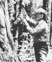
Dick Hartesveldt coring a giant Sequoia tree [click to enlarge] |
Richard J. Hartesveldt (1921 - 1975), The Devil Postpile National Monument (Yosemite: Yosemite Natural History Association, 1952). 14 pages. Illustrated. 23 cm. Saddle stitched with a paper wrapper. Originally published as Yosemite Nature Notes 31(10):136-149 (October 1952)
Digitized by Dan Anderson, May 2007,
from a copy at San Diego State University Library.
These files may be used for any non-commercial purpose,
provided this notice is left intact.
—Dan Anderson, www.yosemite.ca.us
| Ebook formats | No images: | Plain text zip | Plucker | HTML zip | Palm Doc | Palm zTXT | Sony LRF | Braille Grade 2 BRF |
| Images: | Plucker | iSilo | Kindle/Mobipocket |
| Online Library: | Title | Author | California | Geology | History | Indians | Muir | Mountaineering | Nature | Management |
http://www.yosemite.ca.us/library/devil_postpile/