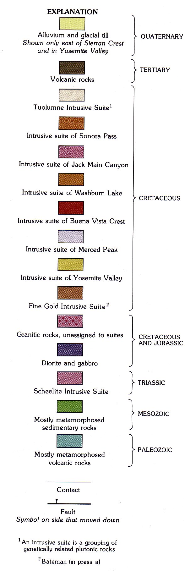
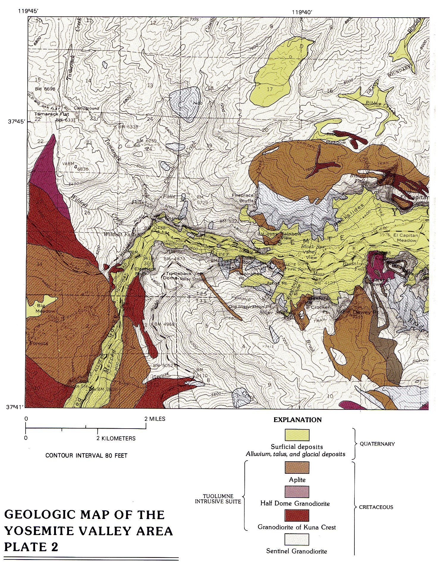
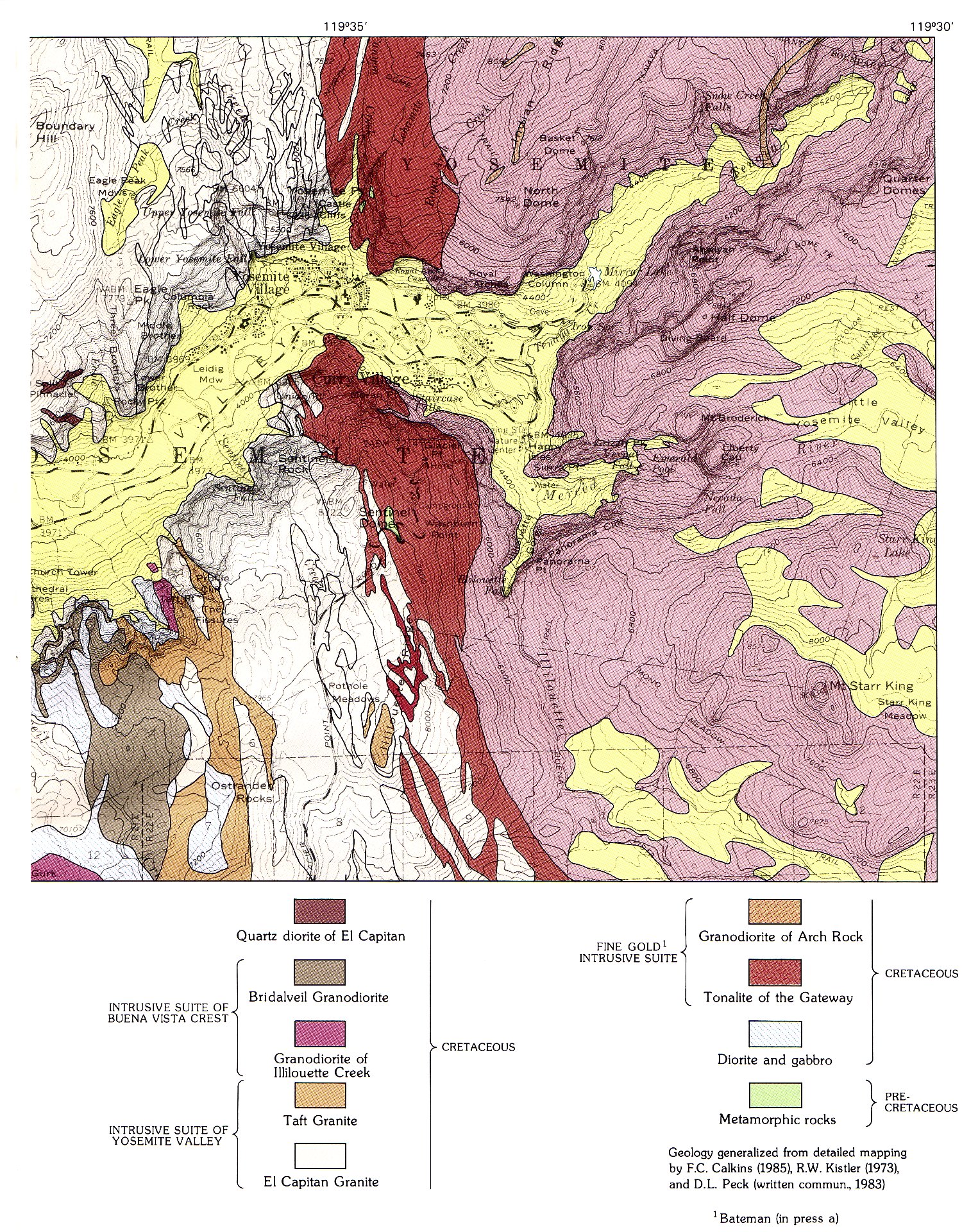
Home A - Z FAQ Online Library Discussion Forum Muir Weather Maps About Search
Online Library: Title Author California Geology History Indians Muir Mountaineering Nature Management

ContentsPrevious: Index

The Geologic Story of Yosemite National Park (1987) by N. King Huber


Geologic Maps

Geologic Map of Yosemite National Park and vicinity
[click to enlarge]

GEOLOGIC MAP OF YOSEMITE NATIONAL PARK AND VICINITY — PLATE 1

Explanation for Geologic Map of Yosemite and vicinity
[click to enlarge]


GEOLOGIC MAPS OF YOSEMITE

A geologic map shows the distribution of different types of rocks at the Earth’s surface. Construction of such a map is usually prerequisite to understanding the geology of any given area. Geologic quadrangle maps at the same scale as topographic quadrangle maps of the U.S. Geological Survey’s 15-minute series (1 in. to 1 mi) currently are available for only a little more than half of the park area. Two other geologic maps are especially suitable to this volume because they show details of Yosemite geology not possible to show at the small scale of the geologic maps herein. A new geologic map of Yosemite National Park and vicinity, at a scale of 1 in. to about 2 mi, has recently been compiled from both published and unpublished geologic mapping by many individuals (Huber and others, in press [Editor’s note: 1989—dea]). A more detailed geologic map of Yosemite Valley is also available (Calkins and others, 1985). The fieldwork for this latter map was carried out by Frank Calkins between 1913 and 1916, but Calkins, the consummate perfectionist, was never completely satisfied with his map and would not let it be published during his lifetime. Though now belatedly published as a historical document, it is still the best geologic map of Yosemite Valley available. These two geologic maps, reduced and generalized, are the basis for the geologic maps in this volume (pls. 1, 2).


Geologic Map of the Yosemite Valley Area (western half)
[click to enlarge]
Geologic Map of the Yosemite Valley Area (eastern half)
[click to enlarge]

GEOLOGIC MAP OF THE
YOSEMITE VALLEY AREA
PLATE 2


Yosemite National Park and Vicinity
[click to enlarge]
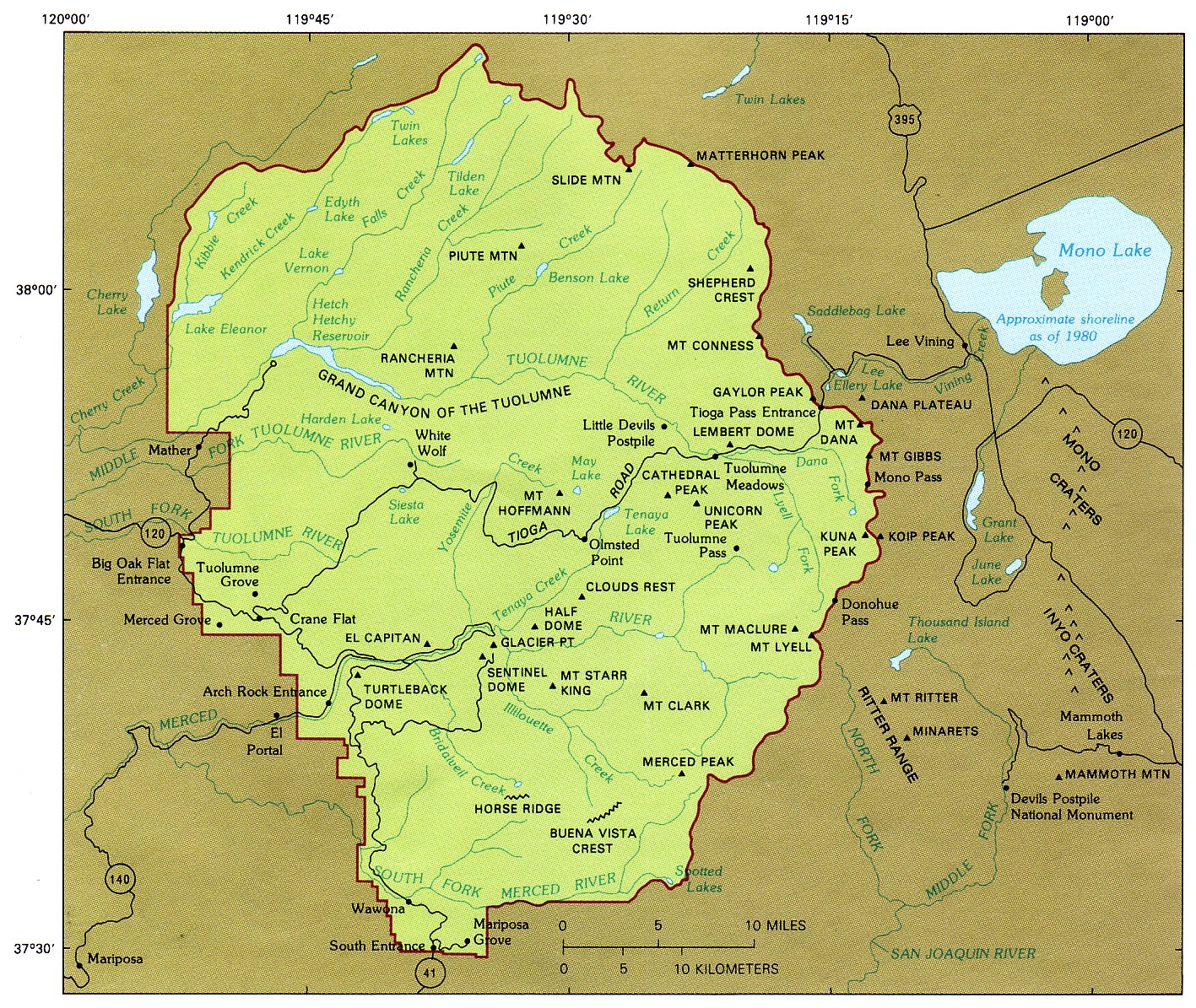
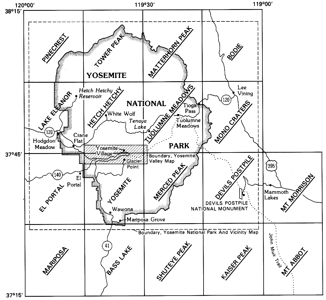
YOSEMITE NATIONAL PARK AND VICINITY — index map showing key localities and geographic features.


Index map for topographic and geologic maps of the Yosemite area
[click to enlarge]
INDEX MAP for topographic and geologic maps of the
Yosemite area. In addition to geologic maps of Yosemite Valley
and Yosemite National Park and vicinity, geologic maps of the 15-minute
quadrangles with underlined names are available.


Index map for 7.5' topographic maps of the Yosemite area
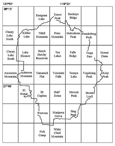
INDEX MAP for 7.5' topographic maps of the
Yosemite area. [Editor’s note: not in original book—dea].


The Geologic Story of YOSEMITE NATIONAL PARK (from back page) U.S. Department of Interior seal (from back cover)


ContentsPrevious: Index

Home A - Z FAQ Online Library Discussion Forum Muir Weather Maps About Search
Online Library: Title Author California Geology History Indians Muir Mountaineering Nature Management

http://www.yosemite.ca.us/library/geologic_story_of_yosemite/maps.html