| Online Library: | Title | Author | California | Geology | History | Indians | Muir | Mountaineering | Nature | Management |
Yosemite > Library > Heart of the Sierras > Coulterville Routes >
Next: Chapter 21 • Index • Previous: Chapter 19
|
Nature never did betray
The heart that loved her.
—Wordsworth’s
Tintern Abbey.
|
|
Converse with men makes sharp the glittering wit,
But God to man doth speak in solitude.
—John Stuart Blackie.
|
|
He prayeth best, who lovest best
All things, both great and small.
—Coleridge’s
Ancient Mariner.
|
As on the Berenda route our course lies up the valley of the San Joaquin, to either Modesto or Merced. We can make either of these towns the place of departure for Coulterville and Yo Semite. If we have chosen the former, the first place reached, we shall find it a goodly-sized town, full of energetic people; and the usual accompaniments of a very prosperous business community of about seventeen hundred inhabitants, including good hotel accommodations (an important consideration just now, as we have to spend the night here). Modesto is the county seat of Stanislaus County.
But, if we have preferred to take the Coulterville Route to Yo Semite via Merced, we keep our seat in the railroad car for about an hour and a half longer, and then alight at the El Capitan Hotel, Merced, where we shall forget ourselves in sleep. This is the county town of Merced County, and a thriving city of one thousand nine hundred inhabitants; with all the usual accessories of business, amusement, and education; and is the center of a remarkably fertile farming district.
Leaving the Southern Pacific at either Modesto or Merced, by stage, we pass over a farming region and rolling country,
|
THE COULTERVILLE ROUTE,
From San Francisco, via Lathrop, Merced, or Modesto, Coulterville, and Merced
|
|||||
| STATIONS. | Distances in Miles. | ||||
| Between consecutive points. |
From San Francisco. |
From Yo Semite Valley. |
Altitude, in feet above Sea Level. |
||
|
By Railway. |
.... | .... | 152.03 | ||
| From San Francisco to— | |||||
|
Lathrop, junction of the Southern Pacific with the Central
Pacific Railroad (b c) |
94.03 | 94.03 | 58.00 | 28 | |
| Merced, on Southern Pacific Railroad (a b c d) | 58.00 | 152.03 | ... | 171 | |
|
By Carriage Road. | .... | .... | 93.66 | ||
| From Merced to— | |||||
| Halfway House, watering place (b c) | 6.35 | 6.35 | 87.31 | 215 | |
| Snelling’s (b c) | 12.60 | 18.95 | 74.71 | 252 | |
| Merced Falls (b c) | 4.58 | 23.53 | 70.13 | 260 | |
| Junction Station (b c) | 5.81 | 29.34 | 64.32 | 578 | |
| Lebright’s Ranch (b c d) | 5.53 | 34.87 | 58.79 | 995 | |
| Herbeck’s (b c) | 5.74 | 40.61 | 53.05 | 1,621 | |
| Coulterville (b c). | 5.57 | 46.18 | 47.48 | 1,665 | |
| Dudley’s Hotel and Ranch (a b c d) | 7.58 | 53.76 | 39.90 | 2,959 | |
| Bower Cave (b c) | 4.69 | 58.45 | 35.21 | 2,360 | |
| Wenger’s Ranch (b c) | 3.23 | 61.68 | 31.98 | 3,218 | |
| Watering trough | 4.00 | 65.68 | 27.98 | 4,120 | |
| Hazel Green (b c d) | 5.51 | 71.19 | 22.47 | 5,550 | |
| Forks of road to Crane Flat | 0.36 | 71.55 | 22.11 | 5,502 | |
| Merced Grove of Big Trees | 2.80 | 74.35 | 19.31 | 5,327 | |
| Big Meadows (b c d) | 8.45 | 82.80 | 10.86 | 4,237 | |
| Junction of Coulterville Road with Merced River Trail | 4.59 | 87.39 | 6.27 | 3,352 | |
| Forks of Coulterville and Big Oak Flat Roads | 2.61 | 90.00 | 3.66 | ... | |
| Leidig’s Hotel (a b c d) | 2.59 | 92.59 | 1.07 | ... | |
| Cook’s Hotel (a b c d) | 0.30 | 92.89 | 0.77 | ... | |
| Barnard’s Hotel (a b c d) | 0.77 | 93.66 | ... | 3,934 | |
|
By Railway. |
|||||
| From San Francisco to— | |||||
| Lathrop, junction of Southern Pacific with Central Pacific R. R. | 94.03 | .... | .... | .... | |
| Modesto, on Southern Pacific Railroad | 20.00 | 114.03 | .... | .... | |
|
By Carriage Road. |
|||||
| From Modesto to— | |||||
| Waterford | .12 | .12 | .... | .... | |
| Horr’s Ranch | .08 | .20 | .... | .... | |
| La Grange | .08 | .28 | .... | .... | |
| Lebright’s | .10 | .38 | .... | .... | |
| Coulterville | .12 | .50 | .... | .... | |
|
RECAPITULATION. |
|||||
| By railway to Merced | 152.03 miles. | ||||
| By carriage road from Merced to Yo Semite | 93.66 “ | ||||
| Total distance via Merced | 245.69 “ | ||||
| ————— | |||||
|
By railway to Modesto | 114.03 ” |
||||
|
By carriage road, Modesto via Coulterville to Yo Semite | 99.46 ” |
||||
|
Total distance via Modesto | 212.44 miles. |
||||
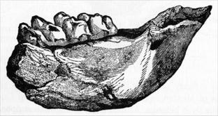
devoted mainly to the raising of wheat; with the great chain of the Sierras in full view before us. On the Modesto branch we cross the Tuolumne River near La Grange, and on the Merced branch cross the Merced River at Snelling. A few miles above the former village the fossil remains of an immense mastodon were found, imbedded in the auriferous gravel of the mine, some ten feet below the surface, beneath an oak tree three feet in diameter. The accompanying illustration, sketched from nature, will indicate its character.
This tooth measured six inches and three-quarters across it, by eight and a half inches from front to back; and the longest
|
|
| FOSSILIZED MASTODON’S TOOTH, AND PORTION OF JAW. |
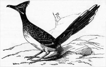
Soon after crossing both the Tuolumne and Merced Rivers, the beautiful natural parks of the foot-hills of the Sierra, lying between the two rivers, are entered, consisting mostly of “digger” or “bull” pines, Pinus Sabiniana; white post oaks, Quercus Douglasii; and black oaks, Quercus Kelloggii; with numerous shrubs and flowers interspersed between, until our arrival at Coulterville, a mining town of Mariposa, County, one thousand eight hundred feet above the sea. But a few miles before arriving there, near to the Dutch Boys’ Ranch, as it is called, there is frequently to be seen a very singular bird, that invites special attention, and which is known as
|
| THE CALIFORNIA ROAD-RUNNER, Geococcyx Californianus. |
This strange and rare bird, peculiar to California and some portions of Mexico, is sometimes called the Ground Cuckoo, to which family it belongs. At first sight it might be supposed to be a new kind of pheasant, so striking is the resemblance in color and pattern of plumage to that genus; but upon closer examination it is soon discovered to be unlike it in every particular. Owing to its exceeding shyness and uncommon scarcity, there is probably less known about this singular species than almost any other. The late Mr. A. J. Grayson, a loving student of ornithology, succeeded in catching, unobserved, the expression of eye and attitude of this bird just when preparing to spring, and kindly sent me the sketch and accompanying notes:—
So far as I am acquainted, the Road-runner, or, as it is called in Spanish, Courier del Camino, or Pisano, has not been described by any ornithologist. It is a distinct and isolated species from all other birds, roaming about over barren plains and hills in search of lizards, snakes, and other reptiles, upon which it preys. It is almost always seen upon the ground, seldom in trees, unless pursued very closely, when it has been seen to spring from the ground to the branches, a height of from ten to fifteen feet, at a single bound, but prefers running along a road or path; from which habit it derives its name. When discovered, it instantly runs off, with remarkable fleetness, to the nearest thicket or hill, where it generally escapes its pursuers, either by hiding, or by sailing from one hill to another. It is very quick in its motions—active and vigilant; indeed its remarkable swiftness enables it to outstrip a horse.
The most remarkable feature about it is its feet, these being more like those of clinging birds, such as the woodpecker or parrot, having two toes before, and two behind, armed with sharp claws. Its legs being strong and muscular, make it well adapted for running.
Its plumage is rather coarse and rough, of a dusky hue, marked with white and brownish specks on the neck and upper parts, while underneath, it is of a dirty white. The tail is long, the bill strong and slightly curved, eye of a greyish brown, the pupil encircled by a light-colored ring. A bare space extends from the eye to the back of the neck, of a pale bluish color tinged with red. The specimen I have now before me measures twenty-three inches from the tip of his bill to the end of his tail. The tail is eleven and a quarter inches, the bill two and a half inches. I have frequently met with this bird in my travels over the country, and I have never seen one in company with any other bird, either of its own or any other kind. It is excessively shy and solitary, inhabiting the wildest and most unfrequented places. It has no song to cheer its solitude. At times it utters a harsh note, not unlike the sudden twirl of a watchman’s rattle.
One of these birds in my possession is becoming quite tame, and readily feeds upon any kind of raw meat; but prefers lizards and small birds, which it swallows whole—feathers and all. If given to him alive, he will play with them awhile before swallowing them, just as a cat will do with a mouse. I have seen him devour three sparrows, one lizard, and a portion of the breast of a coot, for his breakfast, without experiencing any inconvenience. It is exceedingly ravenous; and, like all birds of that class, has a disagreeable odor; and should, I think, be placed in the order of rapacious birds.
Just before entering Coulterville, some three miles northwesterly, the croppings of an immense gold-bearing quartz ledge stand boldly out at Peñon Blanco (a mountain of white rock); and the vein is crossed within rifle-shot of the hotels. This lode is the most remarkable one, in size and lineal extent, of any one yet found in California, as it can be distinctly traced from the middle of Amador County to the center of Mariposa County, a distance of seventy-five miles, by its stupendous croppings. It is estimated that the various quartz mines on this lode, within the limit stated, have yielded $40,000,000 in gold. As this “Mother Vein,” as it is called, crosses Maxwell’s Creek just below the town of Coulterville, a visit can be paid it while the coach is stopping for the assortment of the mail.
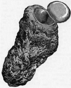
TARANTULAS, Aranea Tarentula.
Here, too, perhaps some enterprising boy or man may bring a tarantula’s nest to show us; and as we examine the peculiarly
|
| A TARANTULA’S NEST. |
They live in nests formed of clay; which is provided with an ingeniously constructed trap-door, made out of about thirty layers of silk and dirt (the former spun from their own body), the inner side of which is also covered with silk, and made water and air tight. The springy strength of the silken hinges of this trap-door is sufficient to instantly close it, the moment the nest is entered. As an additional security to those within there are holes made in the edges of the door, into which the tarantula can insert its fangs, and bolt himself in.
The tarantula, like every living tenant of this world, has its enemy, in a large, hornet-like fly called the pepsis, whose dark blue body, and bright reddish-orange colored wings, enable the curious to closely study his movements; as, with unrelenting vindictiveness, he encompasses the helplessness of his victim. When the pepsis catches sight of his prey, he swoops down upon it with a viz-z-z-zip, viz-z-z-zip, which he continues until the tarantula is utterly paralyzed—not killed. This accomplished, he leaves the defenseless body where it fell, and flies away for assistance. Sometimes it is an hour or more (I once watched for nearly two hours without results) before the victor returns, when he brings with him from three to five coadjutors, who push or pull the body forward until they reach their nest (always built in the ground), into which the tarantula is unceremoniously dropped, and then stowed away on one side. It has generally been supposed that this is simply a provision made for food purposes; but this is incorrect, inasmuch as when the female pepsis has carefully placed the paralyzed tarantula into the corner desired, she then punctures the body, deposits her eggs in the punctures; and the warmth of the paralyzed body continues until the hatching process is completed; then the tarantula dies, and his decomposing body supplies the pabulum needed for the larvae and pupae of the pepsis, until they can fly abroad in the earth to seek their living elsewhere. One singular feature of the enemy of the tarantula, the pepsis, is, that the male dies immediately after sexual contact.
Following up Maxwell’s Creek beyond Coulterville for about two miles, we commence the ascent of a long hill, whence a panorama of the town, the foot-hills, and the distant plains opens up before us. But, once upon its summit, the first grand view of the snow-clad peaks of the High Sierra, the sources of the Tuolumne and Merced Rivers, beyond Yo Semite, is obtained, and an altitude gained of three thousand five hundred feet.
Now the elevated table-like flats, extending for miles, are either under settlement and cultivation, or are occupied by a bounteous forest growth of yellow pine, Pinus ponderosa, and the first seen upon this route. Busy saw-mills, and the woodman’s ax and frow here, once gave both lumber and “shakes” (split boards) for the mines and farms, that necessarily depended upon the mountains for their supplies of these; now, however, as the demand has nearly ceased, the supply has correspondingly dwindled away.
Winding our way among timber-clothed hills we soon arrive at
Where we can spend the night. And the moment we have felt the grip of Mr. Dudley’s manly hand, and looked into his open countenance; or received the undemonstrative welcome of his pleasant wife, there promptly comes a confidence that everything they may or can do for our comfort, will be a spontaneous and cordial act. I have entered many more pretentious way-side inns than this, but have never been better cared for, or kindlier treated than here. If I can say more, why please to consider it said, and I will thank you. Four miles above this we come to
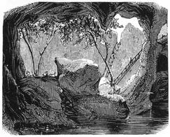
This is a natural cleft in a great vein of limestone, of a singular grotto-like formation, one hundred and nine feet in depth and length, and ninety in width, which is entered by a passage between rocks, not more than three and a half feet wide, at the northern end of an opening in the roof, some seventy feet long by thirteen feet wide. The sides of this great cavity are draped with wild grape-vines, while through it peep the tops of tall maple trees that grow deep down in the cave. When the boughs of these are drawn aside, you look into the abyss below, where sleeps a small pool of water that is forty feet deep, made shadowy and mysterious by overhanging rocks. There is a boat
|
| BOWER CAVE. |
Here the public road ends; but not so the enterprise of the Coulterville people. Desirous of sharing the patronage of the Yo Semite travel, “The Coulterville and Yosemite Turnpike Company” was formed in 1859, and the road extended, by this company, to Crane Flat, some eighteen miles distant, at a cost of about $15,000.
But, as Yo Semite lay still far beyond, and both passengers and freight had to be transported thither on the backs of horses and mules, and over rough and precipitous trails; and although it was deemed impracticable, if not impossible, to construct a wagon road down to the floor of the valley, from the high cliffs that margined it in; and this work could only be accomplished by the aid of the best engineering skill, after the expenditure of large sums of money, the Coulterville and Yosemite Turnpike Company, stimulated to this action by Dr. John T. McLean, its President and largest stockholder, under an agreement between said company and the Yo Semite Commissioners that the Coulterville Company should have the exclusive lights to construct, and to maintain for ten years, a toll road into the valley, on the north side of the Merced River, undertook the construction of such a road and completed it, in accordance with the agreement above named, on June 18, 1874, at an expense, over and above the expense of that part of the road from Bower Cave to Crane Flat, of over $50,000. Subsequent, however, to the agreement above mentioned being made, and to the commencement of the survey and construction of the Coulterville Road to Yo Semite under it, the Big Oak Flat and Yo Semite Turnpike Company applied to the Yo Semite Commissioners for the privilege of extending their road (already completed to Gentrys, on the northwestern boundary of the Yo Semite grant), down to the floor of the valley. The Commissioners declined to grant this privilege to build a second road into Yo Semite, on the north side of the Merced River, because of the agreement they had previously made with the Coulterville Road Company, under which that company had expended money and acquired vested lights.
The Big Oak Flat and Yo Semite Turnpike Company, applied to the State Legislature, at its next session, for the privilege of extending its road from Gentrys to the level of the Yo Semite Valley, when the Act was passed and approved by the Governor, giving this company the privilege asked, under which it built its road to the level of the valley.
While this Act of the legislature may be regarded as an act of simple justice to the Oak Flat Road Company, which had previously completed its road to the very edge of the Yo Semite grant, there is no doubt that it worked great pecuniary damage and loss to the Coulterville and Yo Semite Turnpike Company, which, under its agreement with the Yo Semite Commissioners for an exclusive privilege for a road into Yo Semite on the north side of the Merced River, had expended many thousands of dollars in the construction of its road, and had it nearly completed, when this Act of the Legislature, allowing a competing road to be built, was passed. But the fact remains, and it is worthy of special and honorable mention, that to Dr. John T. McLean, the President of the Coulterville and Yo Semite Turnpike Company, belongs the honor of making the Yo Semite Valley accessible to wheeled vehicles, by the construction of the first wagon road into it. This road, built and maintained by him at great pecuniary loss, by reason of unexpected competition from the Big Oak Flat Road, is an enduring monument to his energy and enterprise.
After leaving Bower Cave, as we ascend the hill beyond, the scenery grows wilder and more beautiful. Long lines of heavily timbered ridges, intersecting each other like waves of the sea, stretch to the horizon on every hand, with here and there a treeless peak that seems like a desert island in an ocean of pines. There is one very noticeable feature in the scenery of the Sierras, it never grows monotonous or commonplace, as new views open up at every turn in the road. For ten miles from Bower Cave the rise is very gradual on the southern slopes of Pilot Peak Ridge, crossing numerous streamlets, until the pass is reached, and an altitude gained of five thousand three hundred and fifty feet.
Is the boldly defiant cone-shaped landmark of the section, rising to the height of seven hundred feet above the pass, with an elevation of six thousand two hundred feet above sea level. From its summit, to which a branch road is built, all the deep cañons of the Middle Sierras, flanked by high ridges that are covered with dense forests, are in full view, while eastward are seen all the great peaks on the main crest of the Sierras, whence rise the Tuolumne and Merced Rivers; and to the westward extends the broad San Joaquin Valley and the Coast Range; the whole forming a panorama of remarkable grandeur that fully compensates for the short climb from the main road.
From the Pilot Peak Pass the road is built on the backbone of the ridge, affording outlooks on either side, until we enter the dark, tree-formed shadows of Hazel Green, where, owing to its grassy meadows, magnificent timber, and convenience of location, Mr. James Halstead has established a way-side inn.
The forests of the Sierra have their finest development in an elevation ranging from three thousand to seven thousand feet above the sea, and for three miles east and west of Hazel Green, some of the noblest specimens of yellow or pitch pines, Pinus ponderosa; sugar pine, Pinus Lambertiana; red cedar, Libocedrus decurrens; and Douglas spruce, Abies Douglasii, are found. Sugar Pine Pass, two miles southeasterly of Hazel Green, is six thousand eight hundred feet in altitude, and is the highest point on the Coulterville and Yo Semite road. Gently descending for about three-quarters of a mile beyond this we find ourselves in
This grove, five thousand four hundred feet above the sea, is worthy of special mention, as containing some of the best preserved of any of the big tree species. It is directly on the line of the road, the survey having been made with special reference to these attractive studies for the Yo Semite tourist. It contains over fifty Sequoias, the half of which number measure from forty-five to ninety feet in circumference. The largest are remarkably well preserved and beautifully symmetrical, only two or three in the whole grove having been injured by fire. From
Four miles easterly of the Merced Grove, at an altitude of five thousand one hundred feet, the first glimpse of the Yo Semite Valley is obtained on this road. El Capitan, Three Graces, The Sentinel, and Sentinel Dome, with Glacier Point, loom grandly up in the distance; and, going down the eastern side of the ridge, others of the great Yo Semite cliffs and domes unveil their awful majesty, the Half Dome being the most prominent. Jogging along we soon come to
As the name implies, these are extensive grassy flats, that afford excellent pasturage for stock, and where much of the grain-hay used in Yo Semite is produced. How pleasantly does the writer recall the kindly treatment he has received here from its proprietors, Messrs. Meason and Myers, when out upon some of his rambles, and found this a cordial hospice and place of refuge. This is four thousand three hundred and twenty feet above the sea, and only eleven miles from the hotels at Yo Semite. Thought and feeling become enlisted as we draw near the glorious realization of our day-dreams, the present end of our wonderful pilgrimage; and this measurably prepares us for the impressive view before us when we reach the edge of the cliff, and obtain our first look down into the marvelous depths of the Merced Cañon, and of the river, after making its hurrying exit from the valley.
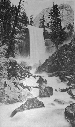
| |
| Photo by Geo. Fiske. | Photo-Typo by Britton & Rey, S. F. |
| The Vernal Fall—Pi-wy-ack. | |
| (See pages 441-42.) | |
This is made by a safe and excellent road, portions of the way having been blasted from the solid granite walls of the cañon. The passage of “Devil’s Gulch,” and other points of the bluff tell how formidable were the obstructions to be overcome when building this road. There is a cranny little spot at the foot of the hill, known as “The Blacksmith’s Shop,” which consists of an irregular chamber formed entirely of huge bowlders that have toppled off and down from the surrounding cliffs, in the “long, long ago.” Here the forge and anvil rung out their merry peals, while picks and drills and crow-bars needed on the road, were being sharpened. No matter how high the thermometer stood upon the outside, this shady, rock-formed retreat, fanned by the rippling frolics of the leaping water of the river, was always refreshingly cool. A slight delay for inspecting this nature-built blacksmith’s shop will be both gratifying and compensating. Once down on the river we begin to realize the height and massiveness of the bluffs that stand, frowningly, on either side of us; and while we are thinking about it, almost before we realize our nearness to it, we pass a leaping rivulet, and are then at the Cascade Falls; but as this forms one of the many delightful excursions of the Valley, further description of this scene now will be unnecessary.
Next: Chapter 21 • Index • Previous: Chapter 19
| Online Library: | Title | Author | California | Geology | History | Indians | Muir | Mountaineering | Nature | Management |
http://www.yosemite.ca.us/library/in_the_heart_of_the_sierras/20.html