| Online Library: | Title | Author | California | Geology | History | Indians | Muir | Mountaineering | Nature | Management |
Yosemite > Library > Indian Village & Camp Sites >
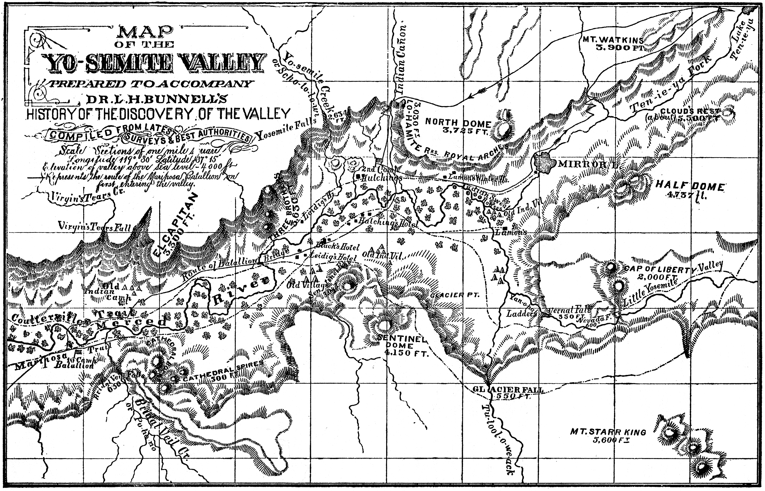
[Editor’s note: This information is historical. Select this link for current Yosemite campgrounds. Compare this article with Map of the Yo-semite Valley that marks 1851 Indian villages and sweathouses in Yosemite Valley (from L. H. Bunnell’s Discovery of the Yosemite, 1st. ed., c. 1880) ]
By C. Hart Merriam [Clinton Hart Merriam, 1855 - 1942]
[Sierra Club Bulletin 10(2):202-209 (January 1917).]
*This article was written in 1910, during which year I was able to complete the list of villages from the head of Yosemite Valley to Ferguson Station on the Merced, about six miles below El Portal. I had previously obtained and published the villages from Horseshoe Bend down the Merced as far as the territory of the tribe extended, and was anxious to fill the gap between Soo-noó-koo-loon at Ferguson and Se-sau'-che at Horseshoe Bend. Not having been able to do this, it seems hardly worth while to defer publication longer.
•
For ages before its discovery by white men Yosemite Valley was inhabited by Indians. Owing to its isolated position and the abundance of mountain trout, quail, grouse, deer, bear, and other game animals, and of acorns, manzanita-berries, and other vegetable foods, it supported a large population. This is attested not only by the statements of the Indians themselves, but also by the surprisingly large number of villages whose locations have been determined. These were of three kinds:. (1) permanent villages, occupied the year round, though somewhat depleted in winter; (2) summer villages, occupied from Alay to October, after which the inhabitants moved down into the milder climate of Merced Cañon, where there was little or no snow; and (3) seasonal camps for hunting and fishing. The camps were definitely located and each was regularly occupied at a particular season.
It has not always been possible to distinguish between village-sites and camp-sites, but, taken collectively, I have been able, with the help of resident Indians., to locate and name no less than thirty-seven. All of these were in the valley proper, and at least six were occupied as late as 1898. To the list I have added sixteen located in the cañon of the Merced from the Cascades to Ferguson Station, six miles below El Portal, making in all fifty-three villages and camps in a distance of about twenty-two miles; and doubtless there were others which my informants had forgotten.
All of these people belonged to the Ahwaneéche or Ahwah'-nee Mew'-wah, a subtribe closely akin to the neighboring Chow-chil'-la Mew'-wah of Chowchilla Cañon. Their language is the southernmost of the three dialects of the once great Mé-wuk family—a family comprising a group of closely related tribes occupying the western foothills and lower slopes of the Sierra Nevada from Cosumnes River south to Fresno Creek.
In this connection it is interesting to recall how the name Yosemite originated. In the early spring of 1851 the valley was invaded by an Indian-chasing expedition. The word Yosemite, said to be the name of the native Indian tribe, was proposed by Dr. L. H. Bunnell, a member of the expedition, and accepted by the others while still in the valley.* [* L. H. Bunnell, “How the Yo-Semite Valley was Discovered and Named,” Hutchings California Magazine, pp. 498-504, San Francisco, May, 1859.] During the early fifties there was some controversy between Bunnell and Hutchings as to whether the proper form was Yo-sem'-i-te or Yo-ham'-i-te (or Yo-hem'-i-te). Hutchings was right, Yo-ham'-i-te being the name of the band inhabiting a large and important village on the south bank of Merced River at the place now occupied by Sentinel Hotel and its cottages. These Indians hunted the grizzly bear, whose name—Oo-hoó-ma-te or O-ham'-i-te—gave origin to their own. The tribe next north of the valley called the grizzly Oo-soó-ma-te, which doubtless accounts for the euphonious form given by Bunnell and now universally accepted.
[Editor’s note: For the correct origin of the word Yosemite see “Origin of the Word Yosemite.”—dea.]
The villages and camps were sharply divided into two categories—those north of Merced River and those south of it. This division has a far deeper and more ancient significance than that indicated by the mere position of the villages with respect to the river, for it goes back to the underlying totemic beliefs that form an important part of the religion of this primitive people.
If one of the survivors is questioned as to the location of the villages, he in replying constantly makes use of the terms inside and outside as denoting one or the other side of the valley; and if the inquiry is pressed a little farther it soon develops that there is a grizzly-bear side and a coyote side, a land side (Too-noó-kah), and a water side (Kik-koó-ah). This perplexing state of affairs leads to the interesting discovery that after all there are only two sides, but that each of them has four names: that the north side, inside, grizzly-bear side, and land side are one and the same—namely, the side north of Merced River; while the south side, outside, coyote side, and water side are only so many different names for the side south of Merced River.
The names most commonly used by the Indians themselves for the two sides are Oo-hoó-mă-tāt ko-tó-wahk (or Oo-hoó-mă-te ha-wā'-ah), the grizzly-bear side, and Ah-hā'-leet ko-tó-wahk (or Ah-hā'-le ha-wā'-ah), the coyote side—from Oo-hoó-ma-te, the bear, and Ah-hā'-le, the coyote, respectively.
It is not difficult to see how Oo-hoó-ma-te, the bear, an important personage among the early animal-people, might be chosen to represent the land animals; but why Ah-há-le, the coyote, should stand for the water-people is not so obvious. For the explanation one must look far back into the mythology of these Indians, in which it appears that before there were any real people in the world Ah-há-le, the coyote-man, one of the early divinities of the animal-people, came over the ocean from beyond the sea—for which reason he is ranked with the water-people.
Returning to our more immediate subject, the village and camp sites of Yosemite Valley, it is now easier to understand the grouping employed by the Indians. Indians are naturally methodical, and it is their custom to classify objects and places, and in speaking of them to begin at a fixed point and proceed in orderly sequence. Thus, in seeking the names of animals and plants and of geographic locations, I have several times provoked the undisguised disgust of my informant by not putting my questions in what he or she deemed the proper sequence.
In enumerating the village and camp sites of Yosemite Valley the Indians begin at the upper (or east) end of the north side—the grizzly-bear side—and proceed westerly to Til-til'-ken-ny at the lower end of the valley, and then cross the Merced to the south side—the coyote side—and return easterly to the upper end.
Following this sequence, the names and locations of the villages and camps are as follows:
1. Hoo-ké-hahtch'-ke.—Situated at the extreme upper end of the valley between Merced River and Tenaya Creek, and just below the mouth of Tenaya Cañon. A summer village inhabited up to about twenty years ago.
2. Hol'-low', or Lah'-koó-hah.—Indian cave, immediately under Washington Column at the mouth of Tenaya Cañon; a low, broad, and deep recess under a huge rock. Said to have been occupied as a winter shelter, and also when attacked by the Mono Lake Piutes. The overhanging rock is black from the smoke of ages, and far back in the cave large quantities of acorn-shells have been found. The word Lah-koó-hah, often applied to Indian Cave, is a call meaning “come out.”
3. Wis'-kah-lah.—A large summer camp on a northward bend of Merced River, a little west of Royal Arches. Western part of site now occupied by a small settlement known as Kinneyville.
4. Yó-watch-ke (sometimes nicknamed Mah-chá-to, meaning “edge” or “border,” because of its position on the border of the valley).—Large village at mouth of Indian Cañon; still occupied. The slightly sloping gravel and sand “fan” on which this village is situated is the warmest place in Yosemite Valley, having a southwesterly exposure and receiving a maximum of midday and afternoon sunshine. Several species of shrubs belonging to the Upper Sonoran zone—the one next below the Transition zone, in which Yosemite Valley lies—thrive on this hot sandy plain among and outside of the scattered ponderosa pines and black oaks. These are Ceanothus divaricatus, Rhus trilobata, Lupinus ornatus, Eriodictyon glutinosum, Pentstemon[sic] breviflorus.
5. Ah-wah'-ne.—Village on Black Oak Flat, extending from site of Galen Clark’s grave easterly nearly to Yó-watch-ke. As in the case of most of the villages, the village name was applied also to a definite tract of land belonging to it. This area, in the case of Ah-wah'-ne, was a piece of level ground of considerable size, beginning on the west along a north and south line passing through Sentinel Hotel and reaching easterly nearly to the mouth of Indian Cañon. The cemetery was on this tract, as was also the barn formerly belonging to J. B. Cooke. This being the largest tract of open level ground in the valley, the name Ah-wah'-ne came to be applied by outside Indians to the whole valley.
6. Koom-i-ne, or Kom-i-ne.—The largest and most important village in the valley, situated on the north side of the delta of Yosemite Creek just below Yosemite Fall (Ah-wah'-ning chú-luk-ah-hu, slurred to Chó-luk), and extending southwesterly at the base of the talus-slope under the towering cliffs for about three-quarters of a mile, reaching almost or quite to Three Brothers (Haw'-hawk). Old Chief Tenaya had a large earth-covered ceremonial-house (hang-e) by a big oak tree in this village. The Government soldiers stationed in the valley took possession of the site and established their camp there in 1907, forcing the Indians out. (Occupied by Indians during all my earlier visits.)
7. Wah-hó-gah.—Small village about half a mile west-southwest of Koom-i-ne, on or near edge of meadow.
8. Soo-sem'-moo-lah.—Village at northwest end of old Folsom bridge (now the ford), less than half a mile south of Rocky Point.
9. Hah-ki-ah.—Large village only a short distance (less than one eighth mile) below Soo-sem'-moo-lah, and likewise south of Three Brothers (Haw'-hawk). A roundhouse, or hang-e, was located here, not far from old Folsom bridge. The three villages, Wah-hó-gah, Soo-Sem'-oo-lah, and Hah-ki-ah, were inhabited up to about twenty years ago.
10. Kotm'-pom-pá-sah, or Pom'-pom-pá-sah.—Small village only a little below Hah-ki-ah, and also south of Three Brothers, or under the talus slope of the cañon immediately west of Three Brothers.
11. Aw'-o-koi-e.—Small village below and slightly east of the tall pine growing in a notch on the broad south face of El Capitan. The native Indian name of the gigantic rock cliff which we call El Capitan is To-tó-kon oo-lah, from To-tó-kon, the Sandhill Crane, a chief of the First People.
12. He-lé-jah (the mountain lion).—Small village under El Capitan a little west of Aw'-o-koi-e.
13. Ha-eng'-ah.—Small village under El Capitan, and only a little west of He-lé-jah.
14. Yu-á-chah.—Still another village under El Capitan, and only a short distance west of Ha-eng'-ah.
15. Hep-hep'-oo-ma.—Village where present Big Oak Flat road forks to leave the main road, south of the steep cañon which forms the west wall of El Capitan, and near west end of the big El Capitan Meadows (To-tó-kon oó-lah' i-e-hu). The five villages, Aw'-o-koi-e, He-lé-jah, Ha-eng'-ah, Yu-á-chah, and Hep-hep'-oo-ma, were summer villages occupied from April to late October or early November.
16. Ti-e-té-mah.—Village only a short distance below Hep-hep'-oo-ma, and close to El Capitan bridge.
17. Ho-kó-nah.—Small village a little below Ti-e-té-mah, and near site of old (shack) house.
18. Wé-tum-taw.—Village by a small meadow a short distance. below Ho-kó-nah, and east of Black Spring.
19. Poot-poo-toon, or Put-put-toon.—Village in rocky place on north side of present road at Black Spring, from which it takes its name.
20. Ah-wah'-mah.—Lowermost (westernmost) village in Yosemite Valley, a short distance below Black Spring and above Til-til'-ken-ny, where the mail-carrier’s cabin is located.
21. Sap-pah'-sam-mah.—Lowermost (most westerly) village or camp on south side of the valley, about half a mile east of Pohono Meadows.
22. Lem-mé-hitch'-ke.—Small village or camp on east side of Pohono (or Bridal Veil) Creek, just below a very large rock.
23. Hop'-tó-ne.—Small village or camp at base of westernmost of the lofty cliffs known as Cathedral Rocks, and close to south end of El Capitan bridge across Merced River.
24. Wé-sum-meh'.—Small village or camp at base of Cathedral Spires near the river, with a small meadow below; not far above Hop'-tó-ne.
25. Kis'-se, or Kis'-se-uh.—Large village near the river, nearly opposite Hah-ki-ah. Kis'-se was the westernmost of the large villages on the south side. From it easterly they occurred at frequent intervals.
26. Chá-chá-kal-lah.—Large village just below old Folsom bridge (ford). Formerly a sweat-house (chap-poó) here.
27. Ham'-moo-ah.—Village on Ford road, nearly opposite Three Brothers (Wah-hah'-kah).
28. Loi-ah.—Large village in open pine forest below Sentinel Rock (on ground now occupied by Camp Ahwahnee) and reaching down toward river. Occupied during my earlier visits-to the valley.
29. Hoó-koo-mé-ko-tah.—Village a little above Galen Clark’s house; looked out easterly over big meadow. Occupied during my earlier visits. (Hoo-koo-me is the great horned owl.)
30. Haw-kaw-koó-e-tah (Ho-kok'-kwe-lah, Haw-kaw'-koi*).—Large and important village on Merced River, where Sentinel Hotel and cottages now stand. Home of the band called Yo-ham'-i-te (or Yo-hem'-i-te), for whom the valley was named. The old woman Callipena was a Yo-ham'-i-te.
[*Named from How-kaw'-met-te, or How-wah-met-te, a rocky place.]
31. Ho-low.—Village on or near Merced River where the schoolhouse used to stand.
32. Wah'-tahk'-itch-ke.—Village on edge of meadow on south bend of Merced River near forks of road west of Le Conte Memorial. The wild pea (wah-tah'-kah) grows here.
33. Too-yú-yú-yu.—Large village on south bend of Merced River due. north of Le Conte Memorial and close to the bridge between Le Conte Memorial (or Camp Curry) and Kinneyville.
34. Too-lah'-kah'-twh.—Village or camp on open ground now occupied by orchard on east side of meadow north of Camp Curry.
35. Um'-ma-taw.—Large village on present wagon-road between Camp Curry and Happy Isles; was some distance from the river; water was fetched from a spring.
36. Ap'-poo-meh.—Camp on Merced River below Vernal Fall.
37. Kah-win'-na-bah'.—Large summer camp in Little Yosemite, whose name it bears.
There were no villages in the narrow Merced Cañon between the lower end of Yosemite Valley and the Cascades, where there were a few houses called Yi-yan'. This name also covered the ground from Cascade Creek to the junction of the Coulterville road.
The next village on the north side was at the terminus of the new railroad at El Portal (a distance of eight or nine miles), where the villages began and continued down-stream. Most of these were permanent, but they were far larger in winter than in summer, receiving material additions from Yosemite when cold weather set in.
Sit'-ke-noó-al-lah.—Place and few houses on the south side of Merced River a little above (east of) El Portal; now Indian Wilson’s place.
Kep-pek'-oo-lah.—Place and small settlement on the south side of Merced River just above El Portal; now occupied by a white man. Named from the abundance of kep-pek' the brake fern (Pteris aquilina), the rootstocks of which the Indians use for the black design in their baskets.
Kah-wah'-koo-lah.—Place and small settlement on the south side of Merced River half a mile below Sit'-ke-noó-al-lah and nearly opposite El Portal stable.
Sal-lah'-to.—Large village on flat now occupied by the railroad terminus at El Portal. The place at the mouth of Crane Creek at El Portal is called Sas'-oo-lah; formerly a few houses where the hotel stable now is.
Po-ko-nó.—Village on the north side of the Merced a quarter of a mile west of El Portal. The flat gravel and pebble bench extending along the north side of the Merced for an eighth of a mile just below El Portal was known by the same name.
Choó-pi-tah, or Choó-pi-do.—Large village on the north side of Merced Cañon one or one and a half miles below El Portal, at the place called Rancheria Flat (immediately west of the present Hite Mine and northeast of the bend of the river).
To-yo'ng-am'.—Small village on top of a small pointed hill on the north side of the Merced at the bend of the river just below Hite Mine (really surrounded by Choó-pi-tah, being situated in the middle of the flat; may have been only a roundhouse).
Soó-wut-oo-lah'.—Large and important village on large oak-forested flat on the north side of the Merced, now Switch Flat (railroad switch), just west of Hogback Ridge, which separates it from Choó-pi-tah. Used to be a roundhouse (hang-e) here.
Oi-kó-bah.—Very small old village at mouth of Moss Cañon, north side of the Merced; not room for many houses.
Kil'-mit-ten.—Big village on flat on the north side of the Merced just above the Government bridge.
Moó-lah-buk'-sa-bah'.—Village on the north side of the Merced just below and close to the Government bridge.
Haw'-too-too.—Village on the north side of the Merced. Old cabin there now, opposite the present Indian ranch where Big Nancy and others live.
Muh-chó-kah-nó.—Old village on the south side of the Merced, at present occupied by Big Nancy, Callipena, and Lucy Ann.
Wah'ng'-oo-hah.—Village on small flat on the north side of Merced Cañon, a little above the mill at Ferguson Mine.
Soo-noó-koo-loon'.—Village on the north side of Merced Cañon, at present Ferguson Station, six miles below El Portal.
Digitized by Dan Anderson, 2004.
These files may be used for any non-commercial purpose,
provided this notice is left intact.
—Dan Anderson, www.yosemite.ca.us
| Online Library: | Title | Author | California | Geology | History | Indians | Muir | Mountaineering | Nature | Management |
http://www.yosemite.ca.us/library/indian_village_and_camp_sites_in_yosemite_valley.html