[click to enlarge]
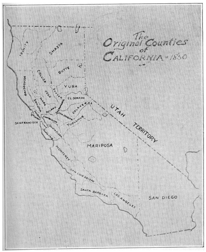
Mariposa County, “Mother of Counties”, one of the original twenty-seven counties.
| Online Library: | Title | Author | California | Geology | History | Indians | Muir | Mountaineering | Nature | Management |
Yosemite > Library > Call of Gold > Prologue >
Next: 1. Indian Wilderness • Contents • Previous: Illustrations
The mountain and hill area west of Yosemite National Park is a vast gold region and is known as Mariposa County. Many people, traveling through this domain, little realize the, romance, tragedy and comedy that has here taken place and the interesting places that still exist, on or in close proximity to its present-day marvelous highways.
The area on the gold road to Yosemite passed through many experiences similar to those of other parts of the great Mother Lode gold-bearing belt of California; but, in addition, it was the scene of famous legal battles; it experienced a famous Indian war, resulting in the discovery of Yosemite Valley; and, later, the Mariposa Grove of Big Trees was discovered; all of which brought into the spotlight citizens who became famous as makers of history.
By first becoming acquainted with important facts of history, showing the part played by Mariposa citizens and Mariposa gold in the development of our Nation, Yosemite travelers can then visit the mines, the old land-marks, the old towns, and visualize personally the rich historical associations, bequeathed us by the California pioneers. History can then be re-lived, enjoyed and better understood. Even the ruins will speak.
The historical and mining districts on the gold road to Yosemite are adjacent to the All-Year Yosemite Highway, which starts at Merced, from which place you travel in an easterly direction for sixteen miles before reaching the Mariposa County line.
Crossing the highway, at this point, is the famous old Millerton road, which, in early days, was the main artery of travel between Stockton and Los Angeles. It followed the edge of the eastern foothills, because such a route was nearer the mines and the river crossings were much easier than in the level plains below.
From the County line, you begin to climb gently through rolling hills. At first, the country is practically treeless as you pass through the shallow slate formation, some of which protrudes from the ground in fantastic shapes. Soon the soil becomes a little deeper and scrub oaks appear and then varieties of pines as you gain in elevation.
At about nine miles, you are in Cathay Valley, [Editor’s note: Cathey’s Valley—dea] with an elevation of one thousand feet. You soon begin to climb Guadaloupe mountain. Just after passing the summit, you enter the famous Fremont Grant and you will be on the Grant for over twelve miles or until you are near the summit, four miles beyond Mariposa.
After entering the Grant, in about three miles you reach Agua Fria Creek, once a thickly populated community. The first Court House was about a half-mile to the north, while about two miles down stream is Guadaloupe Flat, where Captain Diltz erected, in 1854, the first self-feeding ore stamp mill in California.
After passing the next summit, and just as you catch sight of Mariposa, you will notice over to the right in the distance, the ruins of an old mill near Quartz Gulch, where was erected, in 1849, the first steam quartz mill in California.
The Atlantis trees, locally called China trees, on the main street of Mariposa, were planted by Chinese, in early days. The historic Court House, completed in 1854, has been continuously occupied since that time; and in it, one can find the files of the early-day newspapers, which were used, to a great extent, in compiling this history, and the old Court Room, scene of legal battles, with the same Judge’s bench, tables and seats that were used in the days of the original California pioneers. The clock in the tower was installed in 1866. The old Mariposa Gazette building is just across the street from the Court House.
The Mother Lode Highway branches off by the Court House and it will take you to Mt. Bullion (originally called La Mineta and then Princeton), Bear Valley and Coulterville. The Fremont Grant extends from Mariposa to Bagby on the Merced river. A
|
[click to enlarge] Mariposa County, “Mother of Counties”, one of the original twenty-seven counties. |
From Mt. Bullion or Bear Valley, a most interesting trip can be made to the historic town of Hornitos, where one may find many reminders of the days when California was very young; such as the Plaza, where the early miners gathered for their fiestas; the Masonic Hall, built in 1854, a one-story building, where the Lodge, by a special dispensation in its Charter, still meets on the ground floor; the Fandango Hall, in the basement of the Campodonico building, where, on its flagstone floor, Joaquin Murietta, in many disguises, danced; the Ghirardelli building, where a world-famous chocolate manufacturer made his start in 1858; the old Wells Fargo Express Co. building, erected in 1854; the Gagliardo and Cavagnaro pioneer stores, both still being operated by interesting and hospitable descendants; the little stone jail, with its iron door and two one-foot square windows; the beloved Church, on the hill, with its interesting cemetery; the old hotel, where Presidents were entertained; and Dead Man’s Alley, where many a miner was killed and robbed of his gold dust.
A few miles, southeast of Hornitos, is Indian Gulch, probably A little older than Hornitos and with a similar colorful history. Here may be seen the old Solari store, built in 1850 by Charles Murray, in excellent state of preservation and the old blacksmith shop, where real masters of iron formerly presided and where some of their handiwork can still be seen. Here were made the branding irons for the pioneer cattlemen and the design of each has been recorded in the wooden frame of the shop door. The ownership is still in the Solari family and these appreciative and worthy descendants are doing everything they can to preserve the valuable, historical heritage, left in trust to them.
Returning to Mariposa and continuing toward Yosemite, on the All-Year Highway, just after leaving town, over to the left, looms Bullion Mountain, so-named by Fremont, in honor of his illustrious father-in-law, Senator Benton, of Missouri, whose political nick-name was “Old Bullion”, because he was a firm advocate of hard money, like gold and silver.
At about five miles from Mariposa, on the left side of the highway, is located the well-preserved residence, built in 1864, of David Clark, who then operated a saw-mill close by. One and a half miles more brings you to Midpines, a mining center close to the rich mining districts of Sherlocks Creek, Saxon Creek, Sweetwater Creek, Feliciana Mountain, etc. At Midpines, there has been erected a monument showing the exact size of one hundred million dollars of gold, which is approximately the amount of gold mined in Mariposa County, in its first fifty years.
Fifteen miles beyond Midpines, where the All-Year Highway crosses the south fork of the Merced River, there stood in 1849 the trading post of James D. Savage; while a few miles, up the south fork, is Hite’s Cove, where John Hite found the mine that made him a millionaire and where it is said the charred remains of Ten-ie-ya, famous old Yosemite Indian chief, were buried in 1853, after he was killed in a fight with the Mono Tribe.
Twelve miles more, brings you to Yosemite National Park, beautifully described by Mr. S. T. Beal, a friend of the author, in the following hitherto unpublished poem:
Let your thoughts now take flight backward to linger on scenes and transactions, during the years 1849 to 1899, the first fifty years following the discovery of gold in California, illumined by extracts from the columns of old newspapers and from letters, writings and stories of pioneer Mariposans, who were eye-witnesses. Mining development has been given in detail because of its importance, the whole structure of California, having been built on the mining industry.
Next: 1. Indian Wilderness • Contents • Previous: Illustrations
| Online Library: | Title | Author | California | Geology | History | Indians | Muir | Mountaineering | Nature | Management |
http://www.yosemite.ca.us/library/call_of_gold/prologue.html