Yosemite > Library >
Geology of Yosemite Valley >
A Brief Story of the Geology of Yosemite Valley (1943) by M. E. Beatty
|
INTRODUCTION
Prior to 1913, some twelve theories existed explaining the origin of Yosemite
Valley. One widely believed explanation was that a large block, of the earth’s
crust was downfaulted, forming Yosemite Valley, while another theory explained
the valley as the result of a great earthquake which split the rocks in two.
Controversy raged over Whitney’s block-fault hypothesis and John Muir’s belief
that glaciers were largely responsible. Mainly in response to public demand, the
United States Geological Survey undertook the task of working out the geologic
history of the valley. Francois E. Matthes and Frank C. Calkins were assigned
to the problem, and, in the course of several field seasons, covered practically
every foot of the Yosemite region. The present story, consequently, is based on
actual field evidence and is generally accepted by scientists. It is condensed from
Dr. Matthes’
Geologic History of the Yosemite Valley,
Professional Paper No.
160 of the U. S. Geological Survey (available at the Yosemite Museum). The
manuscript for this special issue was reviewed and approved by Dr. Matthes.
|
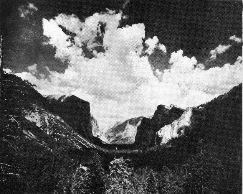
Cover:
Yosemite, Then and Now. Aerial photograph by
Clarence Srock. Ice age painting by H. A. Collins, Sr.
A Brief Story
of the
Geology of Yosemite Valley
By M. E. Beatty
EARLIER MOUNTAIN RANGES
More than 200 million years ago
the area now occupied by the Sierra
Nevada was covered by a shallow
arm of the Pacific Ocean. Sediments,
mainly outwash from the adjoining
land masses, accumulated to thicknesses
of thousands of feet on the
ocean bed. During the Permian
epoch, near the end of the Paleozoic
era, these sediments were uplifted
and folded into the form of mountain
ranges comprised of slate, shale,
and sandstone, alternating with thick
beds of limestone. (See table of
sequence of geologic events on next page.)
In the long period of time that followed,
these mountains were in
large part worn away, and the region
again became inundated by
the ocean. For millions of years, new
layers of mud, silt, and sand, together
with beds of volcanic material,
accumulated upon the submerged
remnants of the first mountain
system. Then, at the end of the
Jurassic period about 130 million
years ago, these new strata were
folded and crumpled and invaded
by molten granite from below. Thus
a secondary system of mountain
ranges was formed that occupied
most of eastern California and large
areas in adjoining states.
Throughout the Cretaceous period,
which followed the Jurassic, the second
mountain system was being
gradually worn down until by the
beginning of the Tertiary period only
ridges of moderate height were left.
The bulk of the original sedimentary
material was thus stripped away
and the granites exposed over large
areas. Remnants of the older sediments,
now considerably altered
and folded, still exist today, particularly
along the crest of the Sierra
and in the lower foothills. A geological
marker has been placed at
one of these sites on the all-year
highway from Merced to Yosemite
about 10 miles west of Arch Rock
Entrance Station. There may be seen
the broken and intensely folded
strata that represent the oldest rocks
of the Yosemite region (see page 6).
SEQUENCE OF EVENTS IN THE YOSEMITE REGION
PERIOD
| PERIOD |
EPOCH |
NATURE OF EVENTS
(Read from bottom of chart to top for sequence)
|
Approximate
Duration in
Years |
| Quaternary |
Recent |
Postglacial time. Return to normal climatic
conditions. Lake Yosemite formed and
filled in, forming present level valley
floor.
|
20,000(?) |
| Pleistocene |
The Great Ice Age. Second series of uplifts
pushed Sierra Nevada up to its
present height of over 14,000 feet. Yosemite
Valley invaded three times by
glaciers. |
1 to 2 million |
| Tertiary |
Pliocene |
Period of relative stability in which the
Merced River developed a rugged mountain
valley more than a thousand feet
in depth. |
10 million |
| Miocene |
Volcanic eruptions begin anew, following
which the first major series of uplifts
caused the Sierra Nevada to stand out
as a block range. Merced River accelerated. |
12 million |
Oligocene
Eocene |
The region, together with the country to
the east of it, is slowly upwarped to
moderate heights. Volcanic activity in the
north part of the range. Continued land
erosion. Birth of Merced River. |
40 million |
| Cretaceous |
|
Mountain ranges gradually worn down
and bulk of sedimentary rock carried
away by streams, uncovering the granite
over large areas. |
75 million |
| Jurassic |
|
Continued deposition of sediments on
ocean bed, followed by folding of strata
into northwestward - trending mountain
ranges. (Mariposa formation). Intrusion
of molten granite into the folds from
below. |
40 million |
| Triassic |
|
Mountains worn down to hills and land
finally sinks below the sea. New sediments
deposited. |
40 million |
| Carboniferous |
Permian |
Sediments uplifted and folded into mountain ranges.
(Calaveras formation.) |
415 million |
| Pre-Carboniferous |
Sediments accumulate on floor of Pacific
Ocean. |
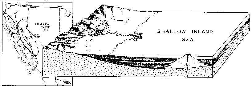
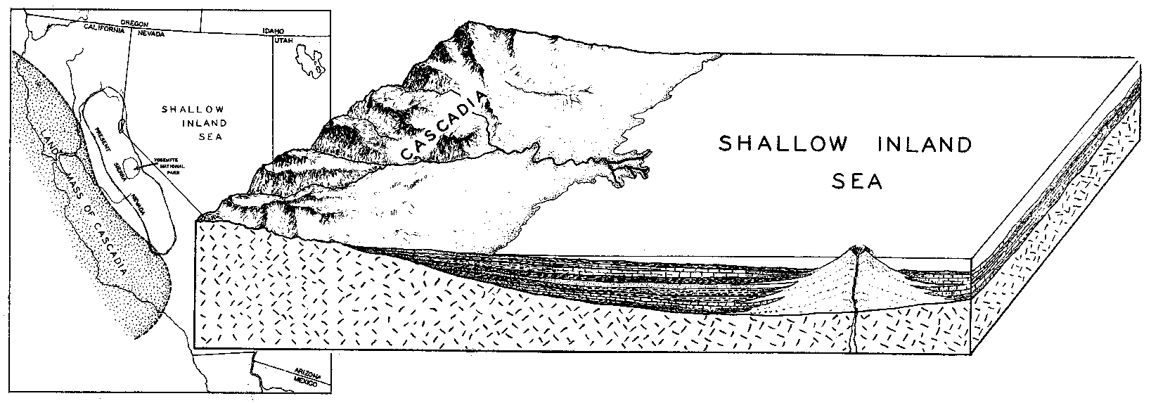
Diagrammatic sketch showing deposition of sediments in ancient inland sea.
|
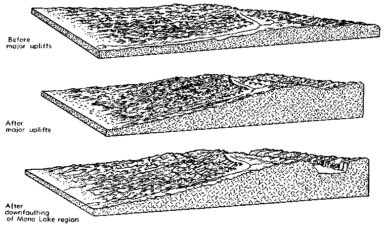
RISE OF THE SIERRA NEVADA
During the early part of the Tertiary
period, the area now occupied
by the Sierra Nevada first acquired
an appreciable slant to the southwest.
For a long period, the region
was gently upwarped to moderate
heights. In late Tertiary time, a series
of uplifts raised the eastern
edge of the Sierra region several
thousand feet and steepened its
western slope.
A second series of uplifts occurred
during the early part of the ice age
(Pleistocene), which raised the eastern
margin of the range to its present
height of over 14,000 feet and
again steepened the grade to the
west. Following this, the Owens
Valley-Mono Lake region was down-faulted,
causing the Sierra Nevada
to stand out as a lofty block range
with a steep eastern front. In this
respect it is one of the world’s outstanding
examples.
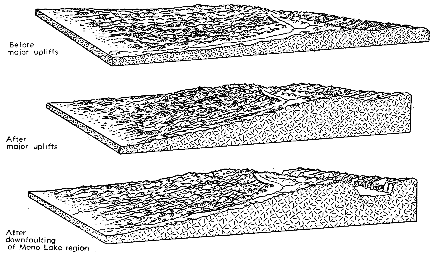
Diagrammatic cross-section of the Sierran block showing rise of the Sierra Nevada and
downfaulting of the Mono Lake region.
|
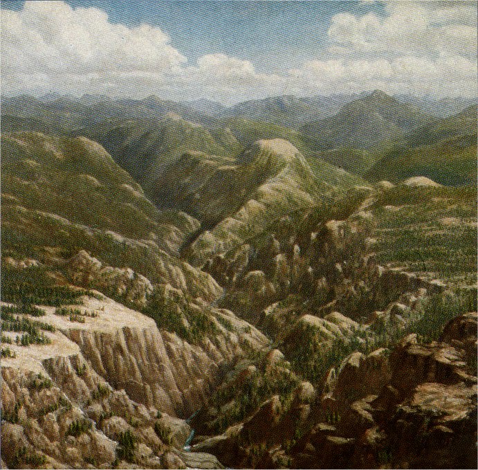
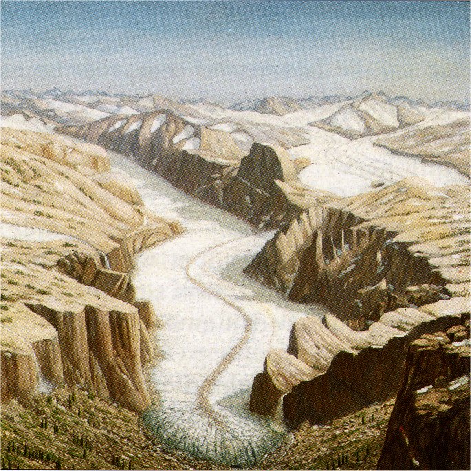
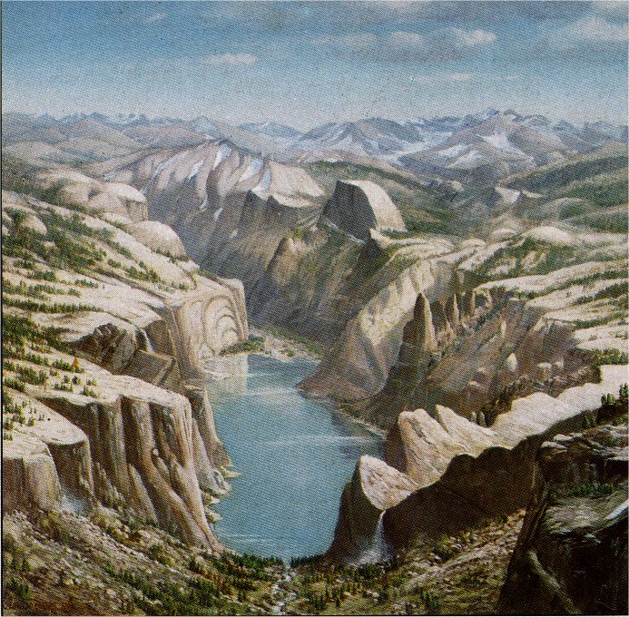
Artist’s portrayal of six stages in carving of Yosemite Valley, as described on following pages.
(Original paintings by H. A. Collins, Sr., displayed in Yosemite Museum)

1. Broad-Valley Stage
|
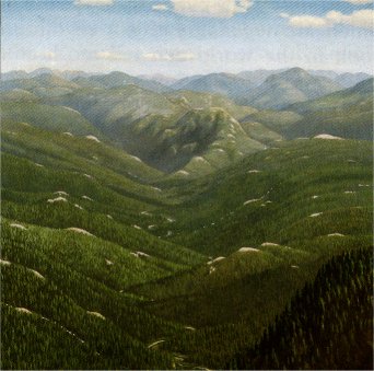
2. Mountain-Valley Stage
|
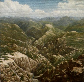
3. Canyon Stage
|
4. First Glacial Stages
|

5. Last Glacial Stage
|

6. Lake Stage
|
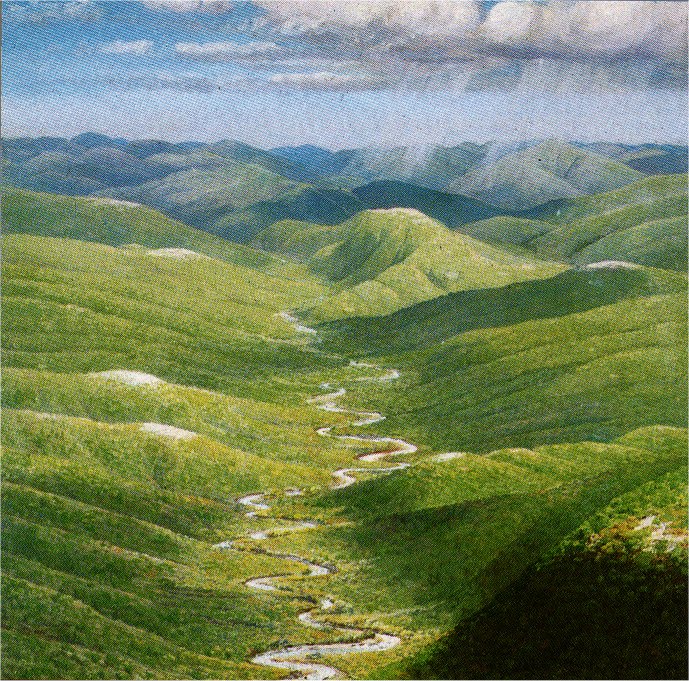
THE CUTTING BY THE MERCED RIVER
1. Broad-Valley Stage:
Prior to the uplifting of the Sierra,
the principal drainage was approximately
north and south. As the area
was tilted to the west, the drainage
was rearranged and new streams
started flowing down the western
slope. One of these master streams,
the Merced River, was responsible
for most of the early cutting of Yosemite
Valley. Evidence shows
three distinct stages of river cutting
corresponding to successive uplifts
of the range. The first or broad-valley
stage represents the time when
the Sierra was still relatively low
and for a long time the Merced
River flowed sluggishly, meandering
back and forth, forming a
broad but shallow valley. El Capitan
at this time was probably a
rounded, wooded hill, rising about
900 feet above the valley floor.
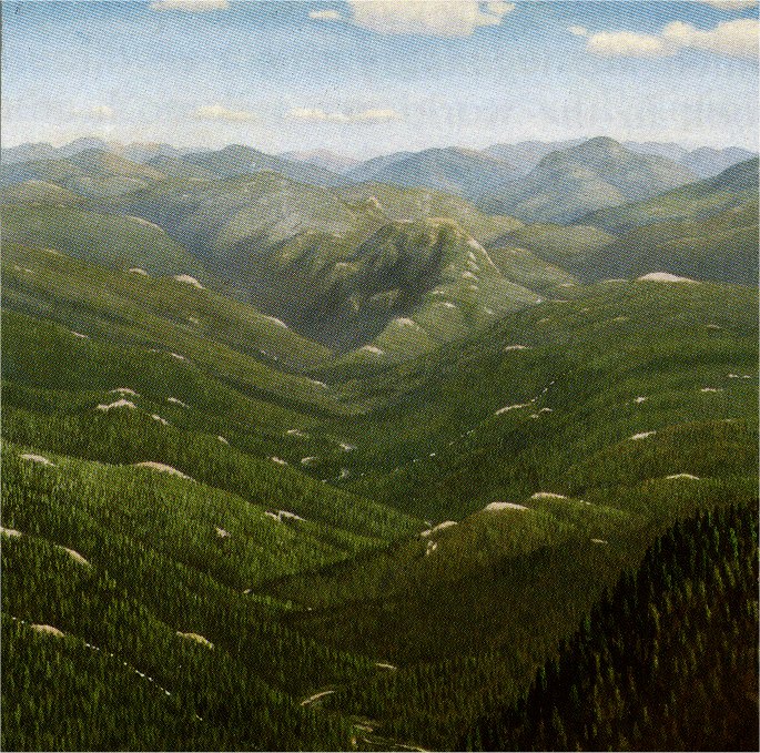
2. Mountain-Valley Stage:
Following the first strong tilting of
the Sierra block, the Merced River
was accelerated. The stream abandoned
its meandering habit and began
vigorously to deepen its bed.
This resulted in the second or mountain-valley
stage of river cutting. By
the end of the Pliocene (epoch prior
to the ice age), a deeper and narrower
valley had been cut by the
Merced River. El Capitan was now
about 1,600 feet above the valley
floor but still retained its rounded,
wooded form.
It was during this stage that the
waterfalls of the valley came into being,
not as the straight, sheer drops
you see today, but as cascades
tumbling down the sloping sides of
the river-cut canyon. Their origin
was due to the inability of the tributary
streams to cut as rapidly as the
Merced River, not being benefited by
the westerly tilt of the range.
3. Canyon Stage:
This third stage of river cutting
took place early in the ice age coincident
with the strong splitting that
pushed the Sierra up to its present
height of over 14,000 feet. The
Merced River was accelerated to
torrential speed, rapidly cutting a
steep-walled inner gorge. El Capitan
stood 2,400 feet above the bottom
of the narrow river-cut gorge,
while tributary streams cascaded
over half a mile down the V-shaped
side walls.
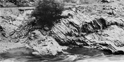
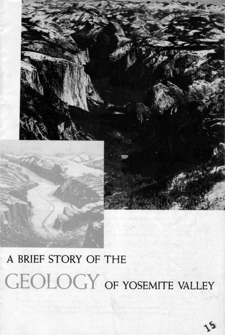
Oldest rocks of the Yosemite region, Merced River canyon. Laid down as ancient sediments
and later folded, they once covered all of the now-exposed Sierran granite.
|
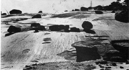
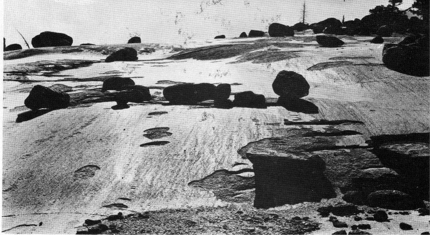
Glacier polish and glacier-transported boulders.
|
GLACIATION OF THE SIERRA NEVADA
During the ice age the climate of
the Sierra Nevada turned wintry and
the higher parts of the range became
heavily mantled with snow and ice.
More snow fell each winter than
could possibly melt during the ensuing
summer; and, in the course
of time, great fields of compacted
snow and, ultimately, glaciers were
formed.
4. First Glacial Stages:
Great glaciers descended the main
river-cut valleys some 50 or 60 miles
to elevations of around 2,000 feet
above sea level where the temperature
was sufficiently high to prohibit
their further advance. Yosemite Valley
was occupied by a huge trunk
glacier, one branch coming down
the Merced River canyon over what
is now Vernal and Nevada Falls,
and the other coming down Tenaya
Canyon, the two joining together at
the head of the valley. Evidence
shows that Yosemite Valley was invaded
by ice at least three times
during the ice age. The first two invasions
were by far the greatest in
depth and extent, the ice bodies filling
the valley to the brim and reaching
a few miles below El Portal.
Glacier Point was covered by 700
feet of glacial ice, but Sentinel Dome,
a mile back, was not overridden.
Other features never covered were
the upper 700 feet of Half Dome, the
top of El Capitan, and the highest of
the Three Brothers—Eagle Peak.
5. Last Glacial Stage:
The last glacier to occupy the
valley was near the close of the ice
age, and, as a result, was much
smaller than the preceding two. It
filled the valley only to a third of
its depth and reached only a little
below El Capitan.
It is difficult to visualize the tremendous
crushing and quarrying
power of those vast ice bodies as
they moved slowly down the river-cut
canyons. The process whereby
glaciers excavate to best effect in
hard rock such as granite is by
plucking or "quarrying" entire
blocks or slabs. These are only rarely
broken off from sound, unfractured
rock. The glaciers take advantage,
rather, of the fractures already existing
in the rock—the joints by which
it is divided into natural blocks and
slabs. Where these fractures are
close together, quarrying will proceed
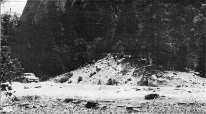
The Bridalveil moraine.
|
with relative ease and rapidity;
but where the joints are far apart,
the blocks are too large and heavy
for even a mighty trunk glacier to dislodge.
Therefore, where the granite
was massive, as in the case of El
Capitan, the glacier could only rasp
and polish.
The structure of the rocks, therefore,
played a very important part
in the amount of sculpturing accomplished
by the ice and explains the
variation in appearance of the principal,
present-day such features of
Yosemite Valley. Considering the
valley as a whole, its profile was
changed from a narrow V-shaped
gorge into a broad U-shaped trough.
It is believed that glaciers were responsible
for about a third of the
present depth of Yosemite Valley
and for the greater part of its present
width at the bottom.
6. Lake Stage:
Most of the evidence of glaciation
in Yosemite Valley today is
from the last glacier which occupied
the valley toward the close of the ice
age. Glacier polish is still visible at
Rocky Point and above Mirror Lake.
A number of moraines in the lower
end of the valley mark the recessional
stages of the last glacial invasion.
One of these, the El Capitan
moraine, lies near the narrowest part
of the valley and is responsible for
the level valley floor of today. The
remnant of this moraine now visible
appears as a high-ridged railroad-like
embankment overgrown with
trees and shrubs. Except for a thin
veneer of humus and soil, it is composed
mainly of boulders of varied
size-material that was deposited
by the glacier while it occupied this
constricted area. At the close of the
ice age, the tremendous volume of
water issuing from the melting glacier
was impounded by this morainal
obstruction; as a result, the valley
floor was flooded by a lake 5½
miles long. Ancient Lake Yosemite
existed for thousands of years, which
was only a short time in the geologic
sense, as lakes have a comparatively
brief life. The great load of silt,
sand, and rock material carried
down by postglacial streams filled
the lake rapidly. Ordinarily, a glaciated
valley has a rounded, U-shaped
bottom; but in Yosemite
Valley the glaciated rock floor is
covered with hundreds of feet of lake
sediment and morainal material,
which accounts for the present level,
parklike valley floor. Recent studies
carried on by geologists of the
California Institute of Technology by
means of soundings indicate that the
depth of the fill varies from only a
few hundred feet at the lower end of
the valley to almost 2,000 feet for the
area between the Ahwahnee Hotel
and Camp Curry.
Due to the prevalence of vertical
jointing in the granite from which
Yosemite Valley was carved, the
glaciers were able to produce, in
many places, nearly vertical side
walls. This changed the cascades of
many of the tributary streams to
sheer vertical plunges. The hanging
valley of Yosemite Creek stands
over 2,500 feet above the valley floor,
and the upper Yosemite Fall has the
distinction of being one of the
world’s highest, free-leaping falls.
RECENT
With the exception of the forming
of Lake Yosemite and its rapid filling
up with sediments, little change
has taken place in the appearance
of Yosemite Valley since the close
of the ice age, which at the time of
Matthes’ work was believed to have
been nearly 20,000 years ago. Later
research, however, indicates a more
recent ending of the ice age. Earthquakes
have played only a minor
part in the accumulation of rock
material at the base of the cliffs, the
bulk of such material having resulted
from the natural weathering
and breaking down of the side walls.
Minor changes are taking place
every year in the cliff features, as
the work of weathering and erosion
continues.
Ed Beatty, 1933
|
About the Author
Matthew Edward "Ed" Beatty was born August 30, 1901.
He was Associate Park Naturalist in Yosemite from 1932 to 1944.
In 1944 he transferred to Glacier National Park in Montana,
where he was Chief Naturalist to 1955.
He was Regional Chief of Interpretation in 1961.
Ed Beatty wrote several articles and booklets for
Yosemite Nature Notes, while he was in Yosemite,
including this one.
Other subjects he wrote about include
birds, bears, firefall, and photographer C. E. Watkins.
M. E. Beatty died October 22, 1989 at Polson, Montana
(which is on the shore of Flathead Lake, south of Glacier National Park).
Bibliographical Information
M. E. Beatty (Matthew Edward) (1901 - 1989),
A Brief Story of the Geology of Yosemite Valley
(Yosemite Valley: Yosemite Natural History Association, 1943).
9 pp. 23 cm.
Illustrated with paintings by H. A. Collins, Sr. photographs, and drawings.
Saddle stitched paper cover [cover image].
Originally published in Yosemite Nature Notes 22(4):33-40 (April 1943).
Reprinted 1948 and subsequently without dates.
The edition used here is undated, probably a 1950s era reprint.
Note: Since this book was written before Plate Tetonics was known,
the reason for the uplift (collision of continental plates) is not mentioned
in this article.
Also, the uplifts described by Matthes are
now thought
to be one continuous stage,
rather than the three separate stages described here.
See
N. King Huber
The Geologic Story of Yosemite National Park (1987)
for a newer and more in-depth book on Yosemite geology.
Digitized by Dan Anderson, February 2005,
from a copy in my collection.
The paintings by H. A. Collins, Sr. were reproduced in black and white.
This online edition uses color photographs of the same paintings instead.
These files may be used for any non-commercial purpose,
provided this notice is left intact.
—Dan Anderson, www.yosemite.ca.us
http://www.yosemite.ca.us/library/history/geology_of_yosemite_valley/