Yosemite > Library >
Geologic Story of Yosemite >
Genesis of Yosemite’s rocks >
Next: Final evolution
•
Contents
•
Previous: Rocks
The Geologic Story of Yosemite National Park (1987) by N. King Huber
GENESIS OF YOSEMITE’S ROCKS
The geologic story of Yosemite as presented up to
this point has been largely a description of the rocks as
we see them now. But how did they get this way? And
when? The search for answers to these questions
involves interpretation of geologic observations made in
Yosemite and elsewhere in the Sierra Nevada, together
with numerous inferences based on accumulated geologic
knowledge and on theoretical concepts. Some
parts of the geologic history can be deciphered with
confidence and in considerable detail, but other parts
are less complete because the geologic data are very
spotty.
A Single Quiet Plate—
The Paleozoic
The framework within which most geologists today
view geologic processes, such as the creation of
batholiths and the building of mountains, is that of the
theory of plate tectonics (see section above entitled
“Plate Tectonics — * * *”). Tectonics is the study of
the deformation of earth materials and the structures
resulting from that deformation. The “tectonics” in
plate tectonics refers to deformation and structure on
a global scale.
The oldest rocks in the Yosemite area were derived
from sediment deposited during early Paleozoic time,
beginning about 500 million years ago. During the
Paleozoic, the area that was to become Yosemite was
near the west edge of the growing North American
Continent. The setting, for the most part, was a
relatively passive one. Paleozoic sediment derived by
erosion of still older rocks to the east was delivered
by ancient streams flowing westward to a sea along
the continental margin. Deposition of such sediment
throughout most of the Paleozoic, though not necessarily
continuous, resulted in the accumulation of
thousands of feet of mud and sand, which eventually
consolidated into shale and sandstone. Plant and
animal life in the sea contributed their part by
depositing calcium carbonate and silica, later to
become beds of limestone and chert.
During the Paleozoic, the continent and its adjacent
sea appear to have been traveling together on a
single plate. All was not totally passive, however,
because there is evidence for folding and deformation
of some early Paleozoic strata during the late Paleozoic.
It is not possible to relate such deformation
to specific plate-margin tectonics because of severe
overprinting by later tectonic events. By the end of
the Paleozoic the geometry at the west edge of the
North American plate had changed, and an oceanic
plate was now underriding, or being subducted
beneath, the North American plate.
A Time of Fire and Upheaval—
The Mesozoic
The presence of a subduction zone along the west
margin of the North American plate had profound
effects on that plate. As the cool oceanic plate was
subducted, the overriding continental plate was
deformed. But more important to the Yosemite story
were the igneous effects of subduction. Wherever convergent
plate margins and subduction zones are present
today, magma is generated at depth, and linear belts of
volcanoes form atop the overriding plate, parallel to the
subduction zone. Mount St. Helens, for example, and
other volcanoes of the Cascade Range lie parallel to an
active subduction zone that extends from northern
California to Canada, and we infer that ancient subduction
zones produced similar belts of igneous activity.
We can only speculate as to the nature of the
physical and chemical processes that take place within
a subduction zone. A prevalent theory is based on
experiments indicating that the presence of water
lowers the melting temperature of rock materials. This
theory holds that water entrapped in the descending
slab of oceanic crust is driven out as the slab reaches
higher temperatures and leaks upward into the overriding
lithosphere, where partial melting results
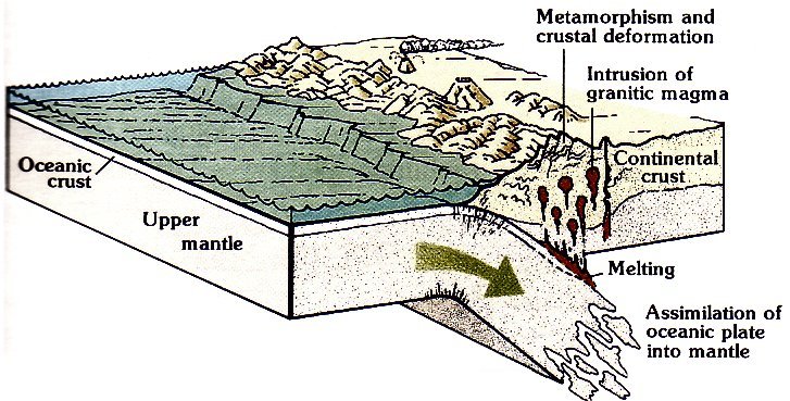
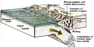
(fig. 28).
Magma generated in the mantle part of the lithosphere
has the composition of basalt or andesite, but as the
magma rises into the continental crust, a more silicic
magma may be generated—one with the composition
of rhyolite or granite. After rising toward the Earth’s
surface, this silicic magma may erupt as rhyolite volcanoes,
or cool and come to rest as great bodies of
granitic rock within the upper crust. Most geologists
now believe that this is the mechanism—greatly simplified
here — through which the Sierra Nevada
batholith was generated and emplaced.
By early Mesozoic time, more than 200 million years
ago, magma reached the Earth’s surface in a belt of
volcanoes and spewed forth to form great volumes of
volcanic rock, metamorphosed remnants of which are
now exposed in the area of the Sierran crest
(pl. 1).
By
this time, silicic magma had also formed, some of
which cooled and solidified below the Earth’s surface to
form bodies of granitic rock; one such body is now
exposed in Lee Vining Canyon (intrusive suite of
Sheelite,
pl. 1).
Subduction along the margin of the
North American plate was not continuous during the
Mesozoic, and subsequent movement of granitic magma
into the upper crust was somewhat episodic; the greatest
volumes were emplaced during the middle Jurassic
and Late Cretaceous. By the beginning of the
Cenozoic, the magmatic system in the Sierran region
shut off, leaving behind the mass of granitic rock we
now call the Sierra Nevada batholith.
Emplacement of plutonic rocks within the upper
crust was probably accompanied by many contemporaneous
volcanic eruptions at the Earth’s surface. Evidence
in the Yosemite area for such eruptions includes
the texture of the Johnson Granite Porphyry
(fig. 21)
and similar porphyries in other intrusive suites, and the
100- to 118-million-year ages of the volcanic rocks near
Mount Dana and in the Ritter Range. In addition,
volcanic eruptions associated with emplacement of the
Sierra Nevada batholith and other contemporaneous
batholithic complexes - now exposed along the western
margin of the North American Continent provide the
only apparent source for the extremely voluminous
deposits of Cretaceous volcanic ash to the east in the
continental interior.
Not all of the oceanic plate was being subducted
during that time, however. Parts of that plate, particularly
the upper layer of marine sedimentary rocks on
the oceanic crust, were added, or accreted, to the
leading margin of the overriding continental crust. The
handed chert in the Merced River canyon west of El
Portal, once part of an ocean floor, was added to the
North American plate by such a process.
The end result of the intrusion of the batholith, the
construction of volcanoes, and the deformation of the
metamorphic rocks was a linear mountain range parallel
to and inboard of the continental margin. This
range has been referred to as the ancestral Sierra
Nevada. Mountains are born, only to be worn down by
erosion; and erosive forces begin to act even as the
mountains are being upraised. Nevertheless, the
ancestral Sierra probably reached elevations above
13,000 ft, similar to those in the Cascade Range in
western Washington and Oregon, a range being constructed
over an active subduction zone today.
What caused magmatism in the Sierra to cease
during the late Mesozoic? Many geologists speculate
that the subducting oceanic slab speeded up and flattened
out, so that the zone of magma generation
shifted eastward. Although there are no giant
batholiths in Nevada, many bodies of granitic and
volcanic rock occur there that are chiefly of Cenozoic
age, younger than the Sierra Nevada batholith.
Once the magmatic construction of the ancestral
Sierra Nevada ceased, erosion became the dominant
force in shaping the range, mostly by removing it.
Before the end of the Mesozoic, some 63 million years
ago, the volcanoes had largely been removed, and the
batholith itself was exposed and being eroded. Sediment
derived from this erosion was transported by
streams coursing down the slope of the range to the
Central Valley, where it now forms deposits as much as
tens of thousands of feet thick. By middle Cenozoic
time, so much of the range had been removed that it
had a relief of only a few thousand feet or so.
[click to enlarge]
|
SUBDUCTION OF AN OCEANIC PLATE
during convergence with a continental plate.
Magma, formed by partial melting of overriding
continental plate, rises into continental plate to form
volcanoes and plutons along a mountain chain.
(Fig. 28)
|
|
The Sierra Grows Again—
The Late Cenozoic
During early Cenozoic time the Sierra Nevada
region was relatively stable, and the range continued to
be worn down faster than it was rising. But during the
late Cenozoic, from about 25 to 15 million years ago, a
dramatic change in plate motion along the edge of the
North American plate occurred, with far-reaching
effects. The oceanic plate that was being subducted
beneath the Sierra Nevada was totally consumed into
the subduction zone, and the plate that replaced it was
moving in a different direction—northwesterly. The
boundary between the North American plate and this
northwesterly-moving plate, called the Pacific plate,
became a strike-slip fault along this segment of California—
the San Andreas fault
(fig. 26).
This change in plate-boundary motion, from convergence
to lateral motion, caused a change in the
pattern of stresses imposed on the Sierran region. The
continental crust east of the Sierra began to expand in
an east-west direction, and the thick, light-weight
Sierran crust began to rise again. The exact mechanism
of this uplift is not understood, but the results are there
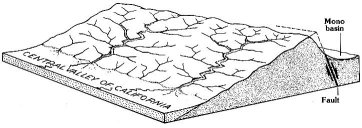
to see. In the Yosemite area, the Sierra is clearly an
uptilted block of the Earth’s crust, with a long slope
westward to the Central Valley and a steep escarpment
separating it from the country to the east
(fig. 29).
Total uplift in the vicinity of Mount Dana during late
Cenozoic time to the present is estimated at about
11,000 ft.
The uplift began slowly and accelerated over time.
The range certainly is still rising—and the rate may
still be accelerating. The estimated current rate of uplift
at Mount Dana, less than 1 1/2 inches per 100 years, may
appear small, but it is greater than the overall rate of
smoothing off and lowering of the range by erosion.
Thus, there is a net increase in elevation. Estimates of
uplift amount and rate are based on studies of lava flows
and stream deposits thought to be nearly horizontal
when formed, but which are now tilted westward
toward the Central Valley. Progressive tilt is indicated
by older deposits with greater inclinations than younger
ones.
François Matthes inferred from his studies that the
late Cenozoic uplift occurred in a series of three pulses,
interrupted by pauses in uplift. In his view, each pulse
initiated a new cycle of erosion and thus produced a
stage of landscape incision characterized by successively
greater relief: Matthes’ broad-valley, mountain-valley,
and canyon stages. More recent studies show that
[click to enlarge]
|
UPLIFT AND TILT of the Sierran block, with east
escarpment formed along fault. Arrows show direction of
movement on fault.
(Fig. 29)
|
|
fortuitous correlation and the commonly local control
of erosion weaken Matthes’ case for three distinct pulses
of uplift. This does not mean that the uplift was
entirely uniform—few things in geology are—but
rather that uplift, once initiated, was more nearly
continuous than he envisioned.
At the same time that the Sierra was undergoing
uplift and erosion and incision by streams, volcanoes
again became active in parts of the range, particularly
north of Yosemite. During the interval from about 20
million years ago to about 5 million years ago, vast
volumes of volcanic material were erupted from a belt
of volcanoes extending along what is now the Sierran
crest north of Yosemite. These volcanoes were the
southward extension of the Cascade Range of volcanoes
still active in northern California, Oregon, and Washington.
With the advent of the San Andreas strike-slip
fault, the subduction complex associated with Cascade
volcanism migrated northward, and the Sierran volcanoes
turned off. Lassen Peak in northern California is
the southernmost volcano of this chain that is still
active.
During this late Cenozoic volcanism, the Sierra
Nevada north of Yosemite was virtually buried by lava
flows, volcanic tuff, and volcanic mudflows. The volcanic
material traveled great distances. Much of it
reached the margin of the Central Valley, and some of
it traveled as far south as the northern part of Yosemite.
Three separate units of this volcanic extravaganza—a
mudflow, a lava flow, and a volcanic tuff—successively
flowed down the valley of a south-flowing tributary of
the ancestral Tuolumne River and into the main channel
in the vicinity of Rancheria Mountain northeast of
Hetch Hetchy
(figs. 30, 31).
Erosional remnants of the
volcanic mudflow indicate that it flowed almost as far
west as Groveland, some 20 mi west of the park. Other
erosional remnants of this mudflow indicate that it was
so thick that it actually flowed upstream along the
ancestral Tuolumne River at least 5 mi above the
junction of the south-flowing tributary.
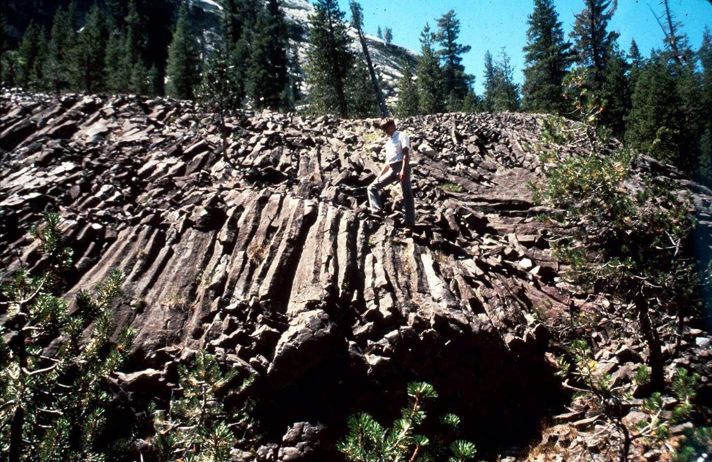
Other volcanic rocks in Yosemite represent local
eruptive events. One such event is recorded by a basalt
plug—a solidified remnant of lava in a volcanic conduit—
locally known as “Little Devils Postpile” and
located on the south side of the Tuolumne River several
miles west of Tuolumne Meadows. The outcrop, easily
reached by the Glen Aulin trail, exhibits crudely
developed columnar joints
(fig. 32).
This basalt is about
9 million years old.
|
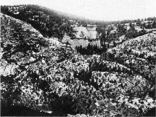
ANCIENT CHANNEL OF THE TUOLUMNE
RIVER on Rancheria Mountain northeast of Hetch
Hetchy. The river flowed westward away from the viewer
into the V-shaped notch cut into granite in the center of the
photograph. About 10 million years ago, the channel and
about 50 ft of river gravel were buried beneath a volcanic
mudflow, the material seen on the slope above the “V”. Its
cross section now exposed by erosion, this ancient channel
was first described as such by Henry W. Turner, who took
this photograph about 1900.
(Fig. 30)
|

[click to enlarge]
|
[click to enlarge]
|
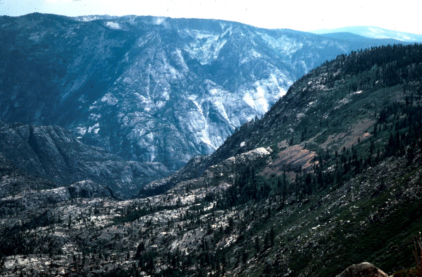
VOLCANIC MUDFLOW DEPOSIT on
Rancheria Mountain. Brown, smooth-appearing
slope to the right, at middle distance, is underlain by
a volcanic mudflow deposit filling an ancient stream
channel. This photograph, which is another view of
the channel in
figure 30,
shows its position on the
slope above Piute Creek, which drains away from the
viewer to the present canyon of the Tuolumne River
in the background. The former Tuolumne River
flowed from left to right into the base of the brown
area, concealed by trees in the center of the photograph,
and at this point was more than 1,500 ft
above the present canyon of the Tuolumne. This
difference in elevation indicates the amount of stream
incision by the Tuolumne River since its former channel
was filled and abandoned and the river was
forced to cut a new one. Photograph by Clyde
Wahrhaftig.
(Fig. 31)
|

[click to enlarge]
|
COLUMNAR JOINTS in a basalt plug—a remnant of a
volcanic conduit—at “Little Devils Postpile,” adjacent to the
Tuolumne River west of Tuolumne Meadows.
(Fig. 32)
|
One small lava flow of basalt, about 3 1/2 million years
old, was erupted just south of Merced Pass, and a few
scattered flows of similar age lie just south and southeast
of the park. These flows record the most recent igneous
activity in Yosemite.
Things have not remained quiet east of Yosemite,
however. A cataclysmic eruption about 700,000 years
ago created 10- by 20-mi-wide Long Valley caldera,
within which now sits the town of Mammoth Lakes.
This eruption spewed forth 2,500 times as much ash as
the 1980 Mount St. Helens eruption; layers of the ash
from Long Valley caldera have been found as far east as
Nebraska. Volcanic rocks of Mammoth Mountain and
the basalt at the Devils Postpile were erupted subsequently.
The Mono Craters and Inyo domes between
Mono Lake and Mammoth Lakes have been erupting
episodically during the past few thousand years, and the
most recent domes were formed only about 600 years
ago. Such activity is almost certainly not yet finished.
Next: Final evolution
•
Contents
•
Previous: Rocks
http://www.yosemite.ca.us/library/geologic_story_of_yosemite/genesis.html