Yosemite > Library >
Geologic Story of Yosemite >
Rocks, the building materials >
Next: Genesis of Yosemite’s rocks
•
Contents
•
Previous: Geologic overview
The Geologic Story of Yosemite National Park (1987) by N. King Huber
ROCKS, THE BUILDING MATERIALS
Yosemite is renowned for its magnificent rock
exposures. Although granitic rocks dominate the
Yosemite scene, various metamorphic and volcanic
rocks are also present. Together, these rocks form
Yosemite’s foundation.
Granite, Granite Everywhere
Granite, in the broad sense of the term, is a massive
rock with a salt-and-pepper appearance due to random
distribution of light and dark minerals. The mineral
grains are coarse enough to be individually visible to
the naked eye.
Granite is a plutonic igneous rock. There are two
types of igneous rock—plutonic and volcanic. Both
types result from the cooling and solidification of molten
rock, or magma. Magma originates deep within
the Earth and rises toward the Earth’s surface at
temperatures of about 1,000 °C if granitic in composition
and of as high as 1,200 °C if basaltic—by
comparison, steel melts at about 1,430 °C. Magma
that cools and solidifies within the Earth’s crust forms
plutonic rock (named for Pluto, the Roman god of
the underworld). The slow cooling of plutonic
magma fosters the growth of individual crystals visible
to the naked eye. In contrast, magma that erupts
at the Earth’s surface, where it is known as lava,
quickly cools into volcanic rock. Thus, having insufficient
time to grow, most mineral grains in volcanic
rock are so small that a microscope is needed to
distinguish them.
The plutonic terrane in the Sierra, once thought
simply to represent local variations in one huge mass
of granite, is actually made up of many individual
bodies of plutonic rock—plutons—that formed from
repeated intrusions of magma into older host rocks
beneath the surface of the Earth. These plutonic
rocks, formerly deep within the Earth, are now
exposed at the surface, owing to deep erosion and
removal of the formerly overlying rocks; they form
the monoliths and domes of Yosemite within the
lofty Sierra Nevada.
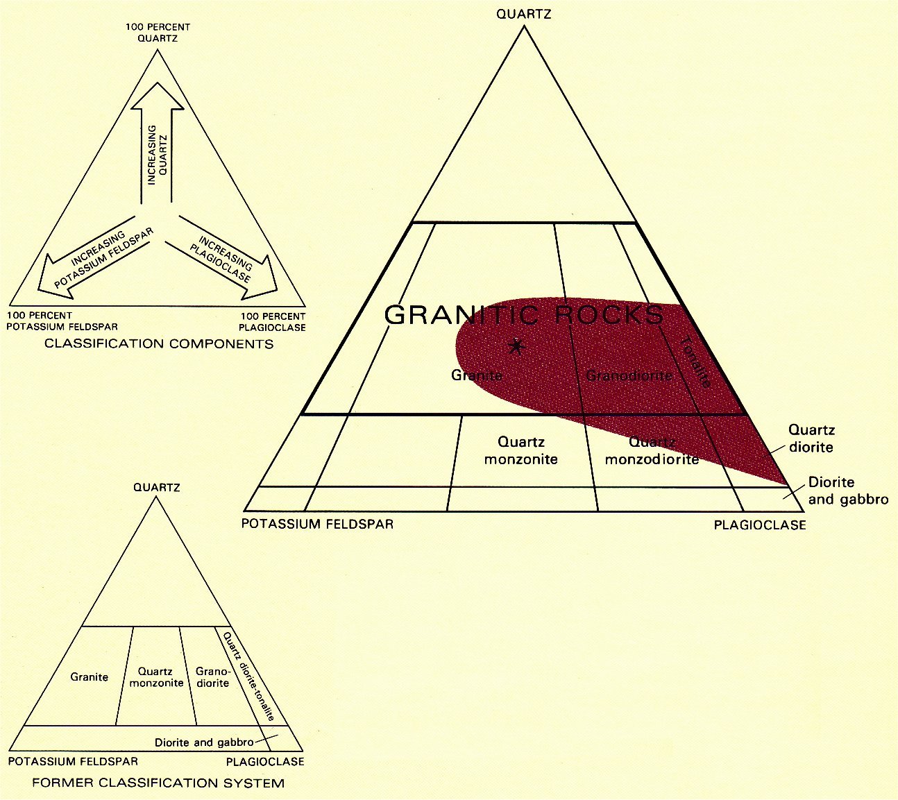
|
PLUTONIC-ROCK CLASSIFICATION, showing classification
components, the formerly used system, and the one now
used worldwide. Red area indicates general range in composition
of plutonic rocks, exclusive of dikes and other small bodies, in the
Yosemite area; names for rock types not occurring in the area are
omitted. Star in center of triangle indicates composition of a rock
containing equal proportions of quartz, potassium feldspar, and
plagioclase.
(Fig. 9)
–CLASSIFICATION OF PLUTONIC ROCKS–
Names for the more common varieties of plutonic
rocks are based on the relative proportions of quartz,
potassium feldspar, and plagioclase, as plotted on a
triangular diagram, with each corner representing
100 percent of that constituent
(fig. 9);
other minerals
present are ignored. The greater the percentage of
any one of these three minerals in the rock, the
closer the rock’s composition would plot to the corner
for that mineral. A rock with equal percentages of
the three minerals would plot in the center of the
diagram (*), and the rock would be called a granite.
Increasing the percentage of plagioclase at the
expense of potassium feldspar would move the composition
toward the granodiorite compartment on the
triangular diagram. “Granitic rocks” are those that
lie within the heavy-lined boundary.
The rock classification used in this volume was
adopted by an international commission in 1972 and
is now used worldwide. This classification differs
from the one previously in use and thus results in
many contradictions with the rock names in earlier
geologic writings on the Sierra Nevada. Nearly all
the granitic rocks in the Sierra previously called
quartz monzonite fall within the granite classification
of the present system, and quartz monzonite is
relegated to a small compartment below granite on
the triangular diagram; the old system is shown for
comparison. In some cases, rocks previously called
quartz monzonite are now called granodiorite
because of better knowledge of their actual mineral
composition.
|
The collection of plutons in the park is part of a
larger mass of plutonic rock called the Sierra Nevada
batholith (from the Greek words bathos, deep, and
lithos, rock). Although this large mass of granite
forms the bedrock of much of the Sierra Nevada, it is
different from the range itself and originated many
tens of millions of years before uplift, weathering,
and erosion shaped the present range. It needs to be
emphasized that the batholith is composite, a fact
not perceived by the earliest geologic studies. Distinguishing
between individual plutons that represent
separate episodes of intrusion and solidification of
magma is the key to understanding the origin and
complex geologic history of the batholith. Geologists
have mapped more than a hundred discrete masses of
plutonic rock in the vicinity of Yosemite National
Park alone, attesting to the complexity of what was
once thought to be a relatively simple batholithic
setting. Emplacement of the Sierra Nevada batholith
at depth may have taken as long as 130 million years.
Five minerals compose the bulk of the plutonic
rocks of the batholith: quartz, two varieties of
feldspar (potassium feldspar and plagioclase), biotite, and
hornblende. All contain the elements silicon and
oxygen, and all except quartz contain aluminum as
well. Other constituents of the feldspars include
potassium, sodium, and calcium; greenish-black
hornblende and the black mica, biotite, also contain
magnesium and iron. The
section on common minerals in granite
provides clues on how to identify
these minerals.
Plutonic rocks consisting chiefly of quartz and feldspar,
with only a minor amount of dark minerals, are
loosely called granitic rocks. Granitic rocks, such as
granite, granodiorite, and tonalite, differ primarily in
the relative proportions of these minerals
(fig. 9).
For
example, granite, in the technical sense of the term,
contains much quartz and both potassium feldspar and
calcium-rich feldspar (plagioclase). In outcrop, it is
generally difficult to distinguish the relative percentages
t potassium feldspar and plagioclase. In the laboratory,
the feldspars can be distinguished by applying chemicals
that stain potassium feldspar yellow, plagioclase red,
and leave quartz uncolored
(fig. 10).
By this means, the
relative percentages of the three minerals can be determined
easily.

[click to enlarge]
|

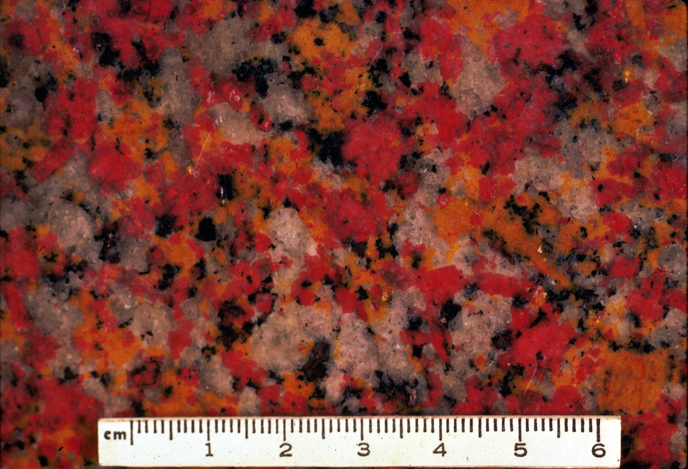
[click to enlarge]
|
|
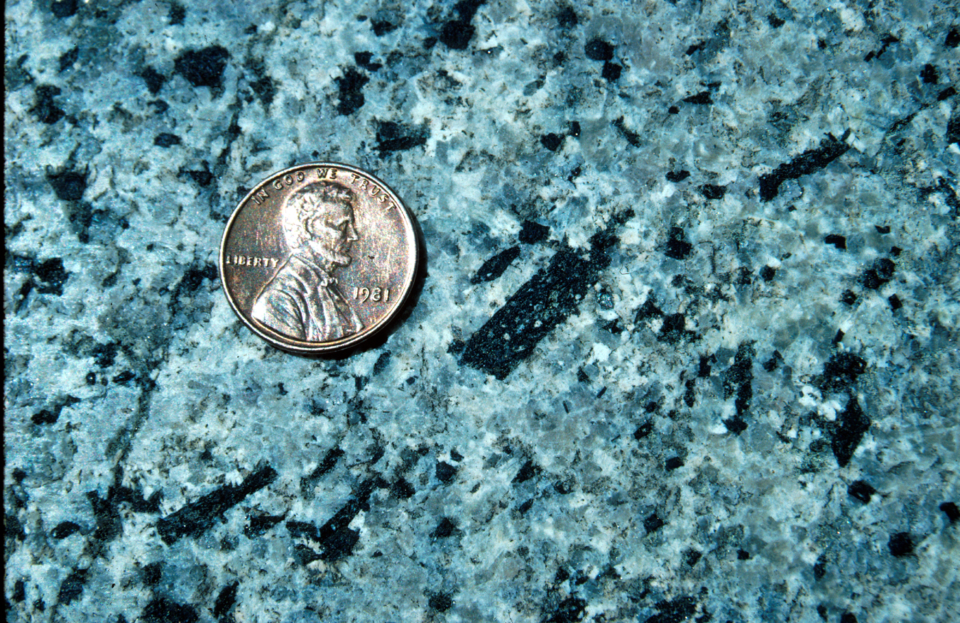
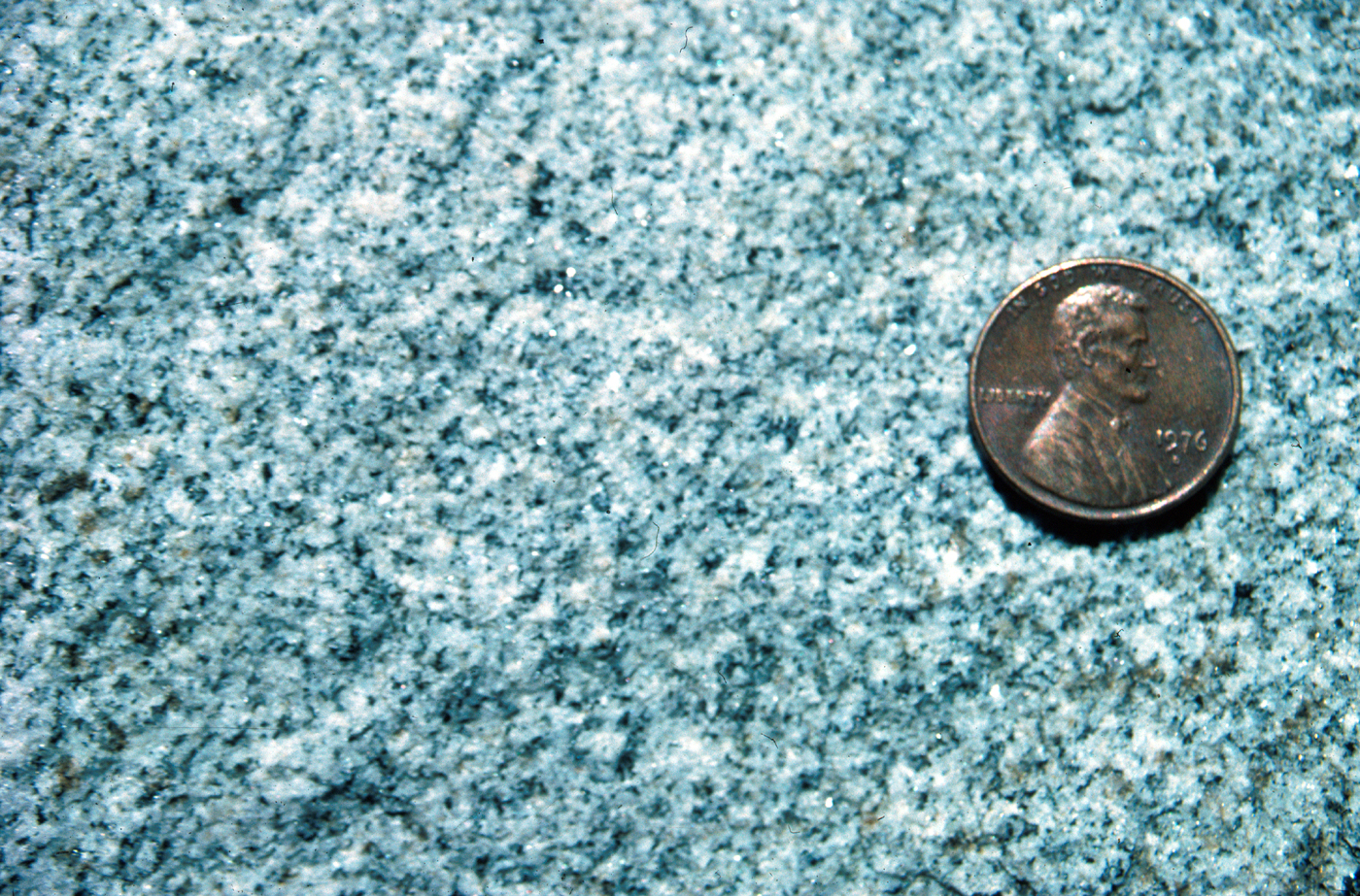
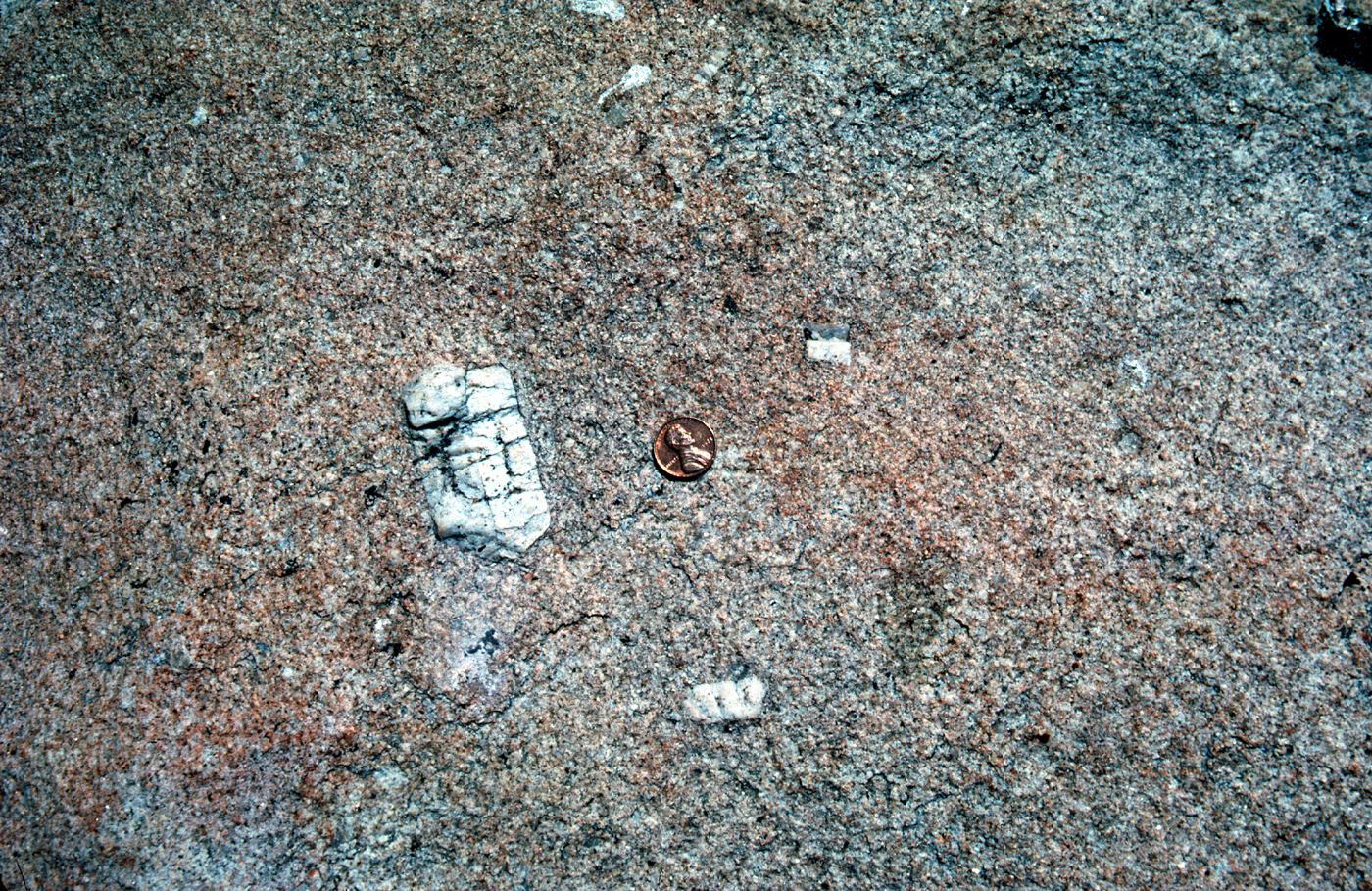
EL CAPITAN GRANITE. A, Freshly broken surface of the
rock. B, Rock surface chemically etched and stained to differentiate
potassium feldspar (orange yellow), plagioclase (red), and
quartz (uncolored).
(Fig. 10)
|
Granodiorite
(fig. 11)
is similar to granite but contains
about twice as much plagioclase as potassium
feldspar. Tonalite contains even less potassium feldspar.
In addition to quartz and feldspar, dark minerals, such
as hornblende and biotite, further characterize individual
plutonic-rock types, as is commonly indicated with
modified names, such as hornblende granodiorite and
biotite granodiorite. Dark minerals are generally more
abundant where potassium feldspar is scarce, and thus
granodiorite tends to be darker than granite, and most
tonalite even darker.
[click to enlarge]
|
[click to enlarge]
|
[click to enlarge]
|

[click to enlarge]
|
|
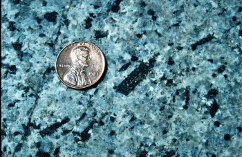
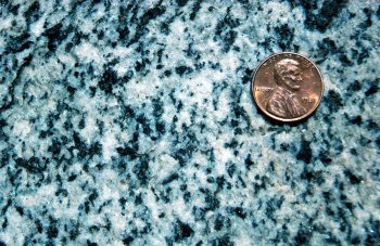
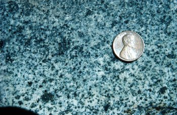
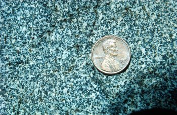
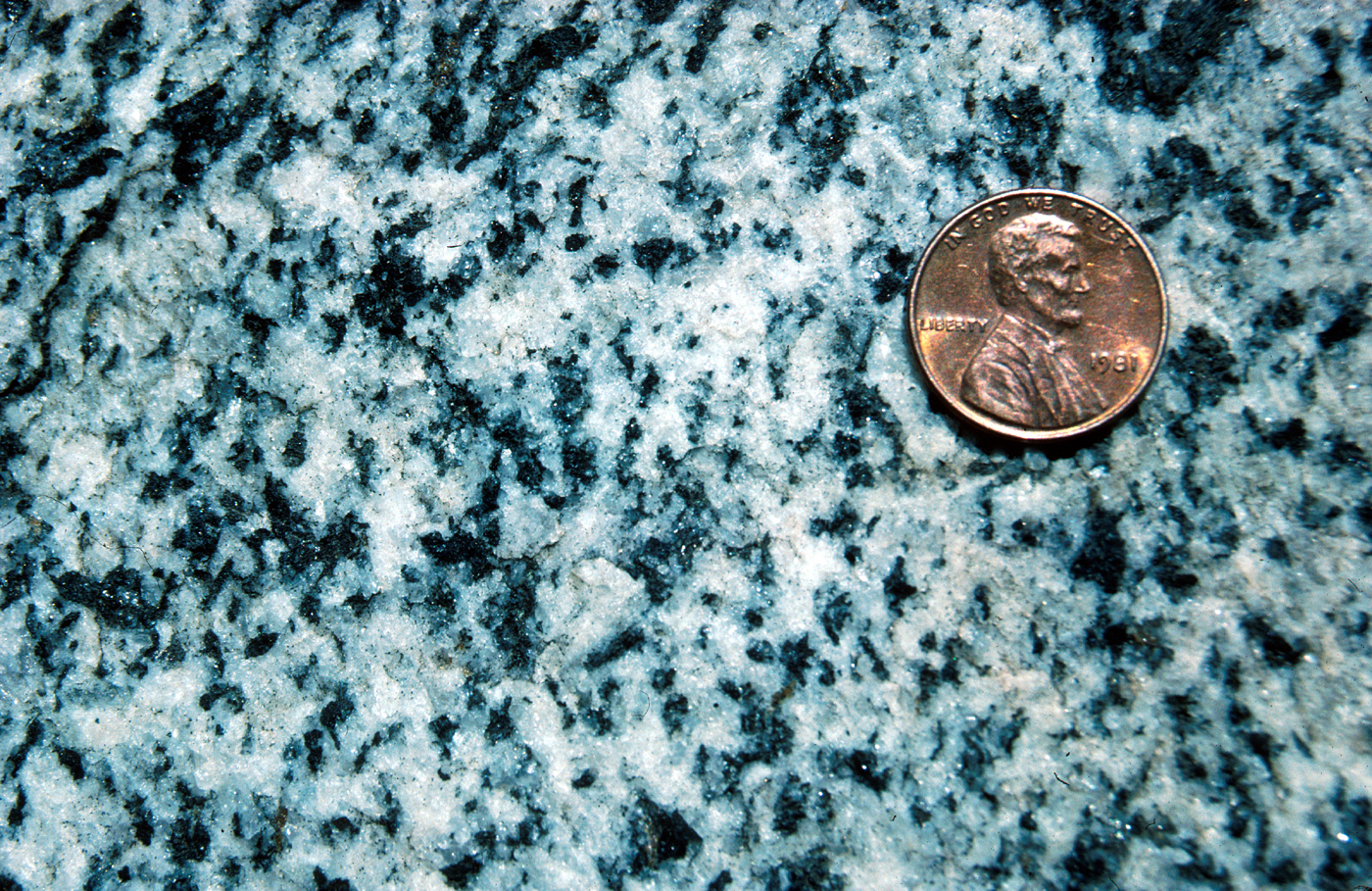
VARIETIES OF GRANODIORITE. All these granodiorites
have about the same mineral composition but differ in texture:
Half Dome Granodiorite (A) contains large, well-formed
hornblende crystals; Sentinel Granodiorite (B) contains both
biotite and hornblende in poorly formed crystals; Leaning Tower
Granodiorite (C) has a spotted appearance from rounded clots of
dark minerals; and Bridalveil Granodiorite (D) has a salt-and-pepper
appearance from fine, evenly distributed light and dark
minerals.
(Fig. 11)
|
In contrast to granitic rocks, quartz diorite, diorite,
and gabbro contain mostly plagioclase and dark minerals,
with little or no quartz or potassium feldspar
(figs.
9, 12).
In addition, the plagioclase in gabbro contains
more calcium than the plagioclase in diorite. Such
plutonic rocks poor in quartz are sparse in the Yosemite
area and generally occur as small, irregular masses and
dikes—sheetlike masses—of quartz diorite or diorite;
they generally are dark gray and commonly are fine
grained, with few minerals readily recognizable to the
naked eye.
[click to enlarge]
|
DIORITE is mostly plagioclase and dark minerals, with little
quartz and potassium feldspar.
(Fig. 12)
|
Light-colored rock, composed chiefly of quartz and
potassium feldspar, also forms irregular masses and
dikes. This rock occurs both with a fine-grained texture—aplite
(fig. 13)
—and with a very coarse grained
texture—pegmatite—displaying large, intergrown
quartz and potassium feldspar crystals. A fine example
of pegmatite is visible a short distance down the
Pohono Trail to Taft Point from the Glacier Point
Road.
[click to enlarge]
|
DIKE of light-colored, fine-grained aplite crosscutting granodiorite.
Aplite is a silica-rich rock composed chiefly of quartz and
potassium feldspar.
(Fig. 13)
|
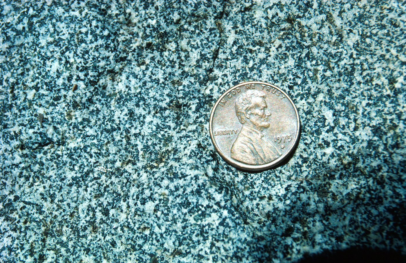
Most granitic rocks contain mineral grains of
about equal size and are said to have a granular
texture. Some granites, however, and many volcanic
rocks have crystals of one mineral considerably larger
than the others; these oversized crystals are called
phenocrysts (from the Greek words meaning “to
appear” and “crystal”), and the texture of such a rock
is described as porphyritic. In Sierran granites, the
most common mineral to occur as phenocrysts is
potassium feldspar, in crystals commonly as much as
2 to 3 in. long
(fig. 14).
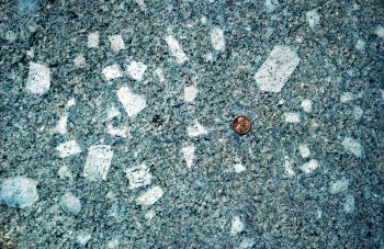
[click to enlarge]
|
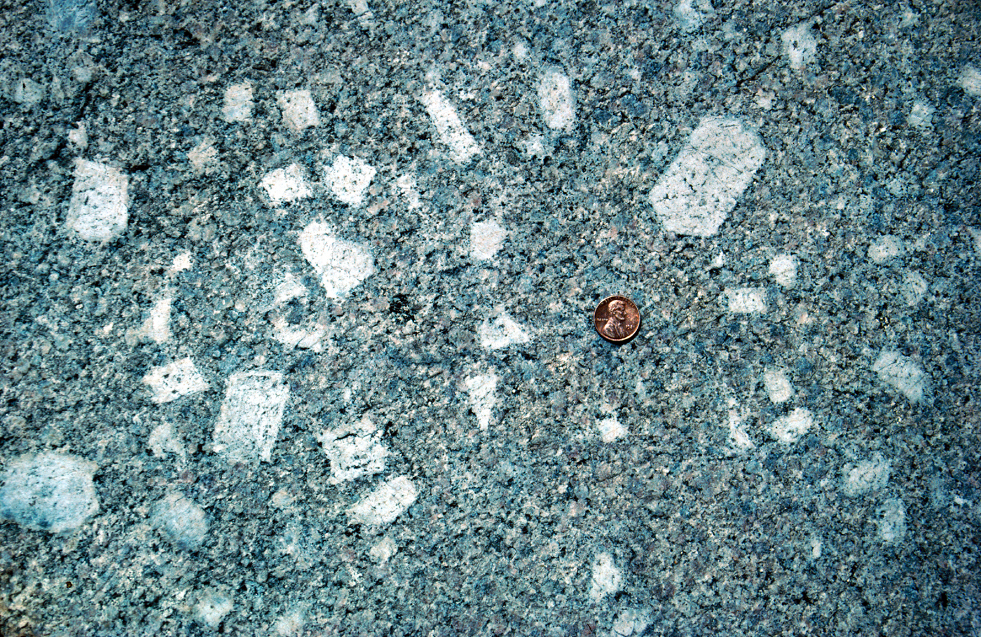
PORPHYRITIC TEXTURE in Cathedral Peak Granodiorite,
with potassium feldspar phenocrysts much larger than the
other minerals in the rock matrix.
(Fig. 14)
|
Rounded inclusions of dark, fine-grained dioritic
material are common in granitic rocks, most commonly
in granodiorites and tonalites. Generally pancake
or football shaped, the inclusions range in size
from a few inches to many feet across. It is not
uncommon for all the inclusions within an area to
have their long dimensions arranged in the same
direction, like a school of fish
(fig. 15).
An excellent
example occurs at the Yosemite Falls overlook on the
north rim of the valley. The origin of these inclusions
is uncertain. Some probably were derived from
preexisting rock; others may be derived from globules
of darker magma that because of their high melting
temperature were chilled by the granitic magma
rather than being digested into it. However, the
shape of the inclusions suggests that, whatever their
origin, they were at least partially plastic while suspended
in the magma and that they were stretched
and given their parallelism by movement within the
magma.
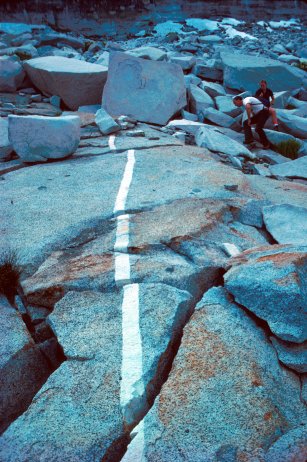
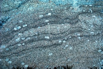
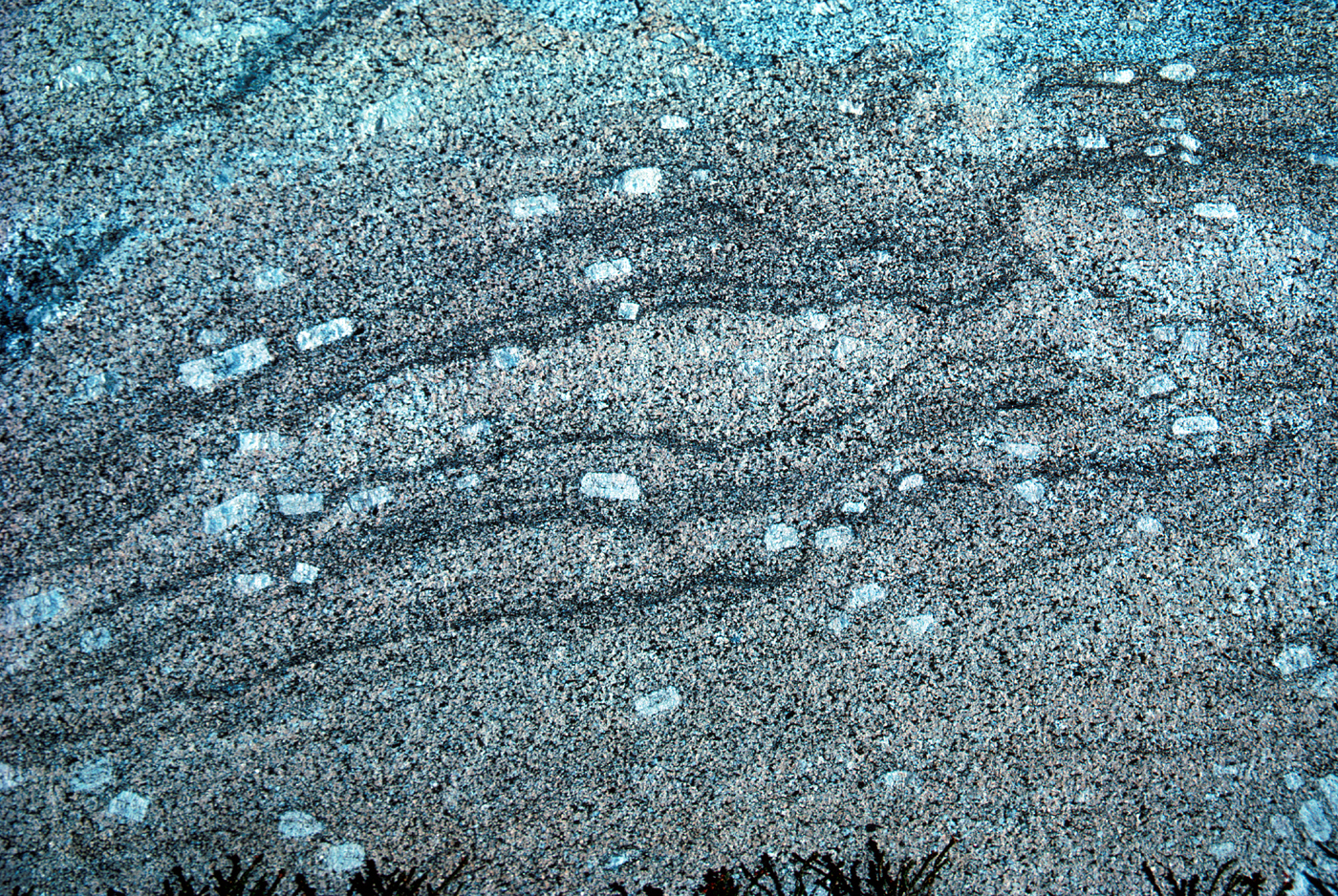
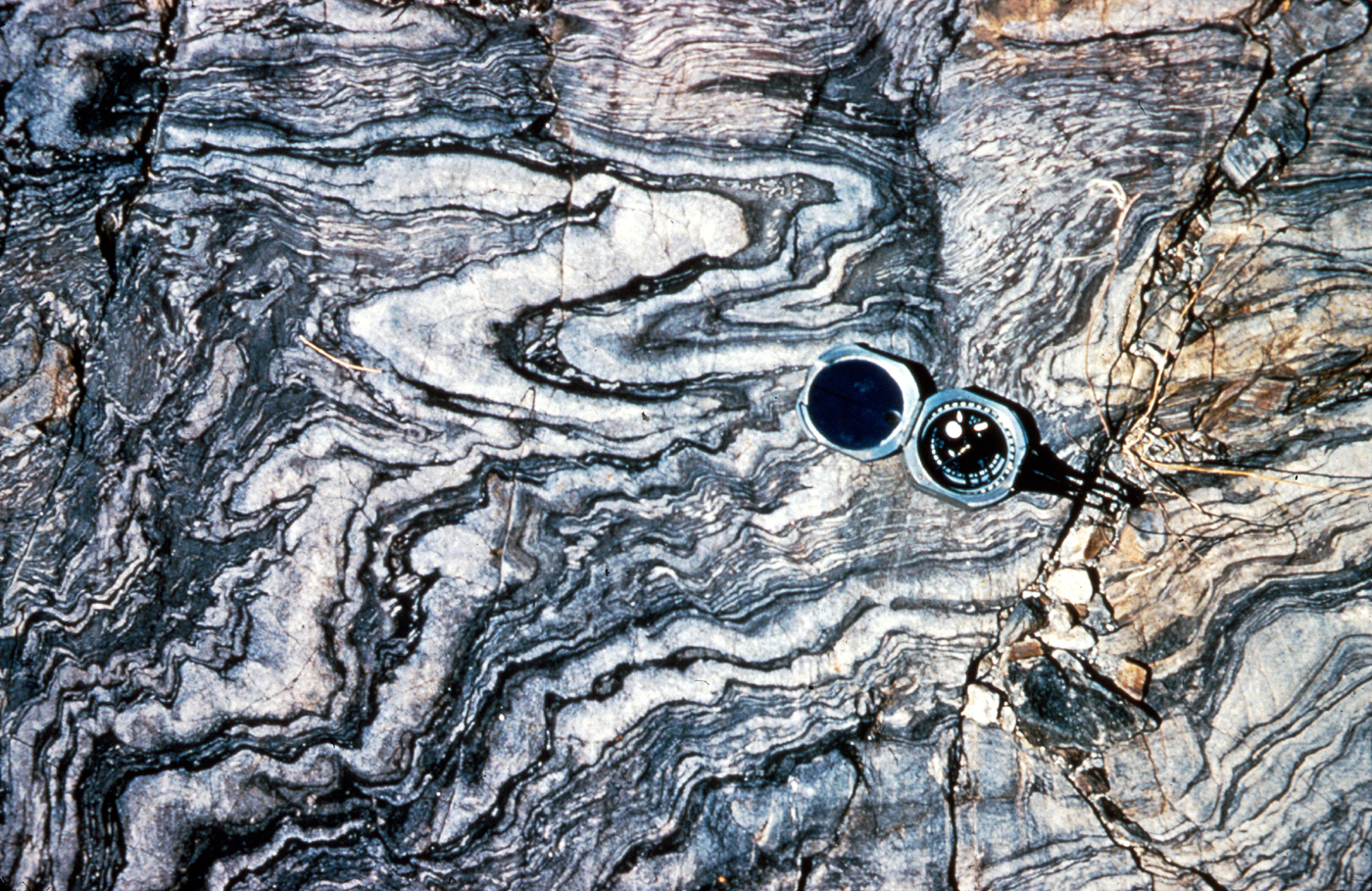
Concentrations of dark minerals sometimes form
wavy, discontinuous streaks and layers, especially
near the outer margins of individual plutons. These
layers, called schlieren (German for streaks), probably
represent clustering of dark minerals early during the
crystallization of the magma, with alignment in
streaks caused by movement within the partially
solidified magma
(fig. 16).
The commonly abrupt
termination of one set of layers by another set suggests
repeated pulses of movement in a magma mush.

[click to enlarge]
|
ALIGNED DARK DIORITIC
INCLUSIONS in granodiorite.
Photograph by Dallas L. Peck.
(Fig. 15)
|
[click to enlarge]
|
SCHLIEREN—streaks or layers
formed by clustering of dark minerals
during differential flow within the
partially solidified magma. Note
parallel alignment of potassium feldspar
phenocrysts by the same process;
larger phenocrysts are about 2
in. long.
(Fig. 16)
|
Individual bodies of granitic rock, particularly large
ones, generally vary in mineral makeup and commonly
overlap the boundaries between specific rock classifications.
Bodies of granitic rock may also overlap each
ocher’s compositional ranges, and so composition is
only one factor in the recognition of separate rock
bodies. The chief distinguishing property may be the
presence or absence of specific minerals, such as biotite,
hornblende, or sphene. Or it may be the general
physical appearance defined by the texture of the
rock—the size, shape, and arrangement (random or
oriented) of the minerals
(fig. 11).
A porphyritic texture
is particularly useful because it is prevalent in only
a few plutons in the Yosemite area. The presence or
absence of dark inclusions may also characterize a rock
body.
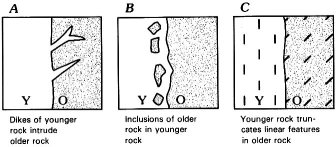
Knowledge of the age relations among plutons is
essential to understanding the geologic history of the
Sierra Nevada batholith. Certain features observed in
outcrop help determine the relative ages of individual
rock bodies. For example, younger magma commonly
shoots thin sheets, or dikes, into cracks in the older
rocks
(fig. 17A).
Additionally, some of the younger
plutons contain inclusions, or fragments of older
rock, which were embedded in the younger rock
while it was still molten
(fig. 17B).
Where dark
inclusions or other oriented structures are present,
the contact between two rock bodies may truncate
structures in the older body, while similar features in
the younger rock may parallel the contact
(fig. 17C).
Determining the absolute age of a given granitic
rock, in millions of years, requires measurement of
the extent of radioactive decay of certain elements,
such as uranium, potassium, and rubidium. From
such measurements and the known rates of decay, we
can approximately determine the time elapsed since
the rock crystallized or cooled enough to stop escape
of the daughter decay products from the rock
(see fig. 7).
In their studies of plutonic rocks, geologists have
devised ways to separate individual bodies of such
rock and to depict them on geologic maps so as to
show their relations to each other and to nonplutonic
rocks with which they are in contact. Once established
by field study, the boundaries of these individual
plutonic-rock bodies—plutons—can be plotted
on a map, and these rock bodies become geologic
map units. After further study, the geologist may
decide that two or more nearby bodies of plutonic
rock exposed on the Earth’s surface are similar in all
essential respects, including known or inferred age.
Even though they may not be connected at the
Earth’s surface, the geologist may thus combine several
masses of similar plutonic rock into a single
geologic map unit, inferring that they are somehow
connected below the surface and represent a single
intrusive episode. This grouping of isolated bodies of
related plutonic rock into a single geologic map unit
is analogous to the grouping of discontinuous
exposures of similar sedimentary rock into formations,
such as the Coconino Sandstone and the
Kaibab Limestone, which are well exposed in the
Grand Canyon region. For ease of reference, the
plutonic-rock units likewise are generally named for
an appropriate geographic feature, plus a compositional
term: for example, the El Capitan Granite, the
Half Dome Granodiorite, and the granodiorite of
Kuna Crest.
[click to enlarge]
|
FEATURES SEEN IN OUTCROP that help determine the
relative ages of plutonic rocks: 0, older pluton; Y, younger pluton.
(Fig. 17)
|
Granitic Rocks of Yosemite
The plutonic rocks of Yosemite have been mapped
and studied in considerable detail. Few of those details
can be shown on the generalized geologic map in this
volume (pl. 1), but a
geologic map at a much larger
scale is available
(Huber and others, in press
).
On that
map, the granitic rocks of the Yosemite area are separated
into nearly 50 different plutonic-rock units, each
consisting of one or more individual bodies of rock. An
even larger scale geologic map is available for Yosemite
Valley (Calkins, 1985; see section above entitled
“Geologic Maps of Yosemite”).
Some plutonic-rock units are further grouped into
intrusive suites. The concept underlying an intrusive
suite is that all the rocks in the suite resulted from the
same magma-producing event. Geologists are most sure
of a common ancestry if the rocks in a suite grade into
each other. Such suites commonly are zoned, both
compositionally and texturally, and generally exhibit
partial or complete nested patterns in which relatively
dark rock in the margins gives way inward to younger,
lighter colored rock in the interior. The units that
compose this ideal kind of intrusive suite are believed to
result from modifications of a common parent magma.
Examples include the Tuolumne Intrusive Suite, the
first intrusive suite to be identified in the Sierra
Nevada, and the intrusive suite of Buena Vista Crest.
The geologic map (pl. 1) groups most plutonic-rock
units into intrusive suites and thus provides a broader
picture of the major pulses of plutonic activity that
contributed to the construction of the Sierra Nevada
batholith. The more detailed geologic map of Yosemite
Valley (pl. 2) delineates not only intrusive suites but
also component units of the suites.
All the plutonic rocks within Yosemite National
Park proper are believed to be of Cretaceous age, with
the possible exception of some small bodies of diorite
and gabbro that may be somewhat older. Some Jurassic
plutonic rock does occur just west of the park, west of
the Big Oak Flat entrance, and some Triassic plutonic
rock occurs east of the park in Lee Vining and Lundy
Canyons. These rocks are included with “Plutonic
rocks, unassigned to suites” on plate 1 and are shown
individually only on the
larger scale geologic map
published separately
(Huber and others, in press
).
Examples of many of the named rock types in
Yosemite are displayed at the Valley Visitor Center,
where they may easily be compared; they are next
described for two readily accessible areas in the park,
Yosemite Valley and the Tuolumne Meadows area.
[click to enlarge]
|
BIRD’S-EYE VIEW
OF YOSEMITE
VALLEY, with selected
landforms identified.
(Fig. 18)
|
YOSEMITE VALLEY AREA
The oldest plutonic rocks of the Yosemite Valley area
compose the walls of Merced Gorge and the west end
of the valley. They include the diorite of the Rockslides,
the granodiorite of Arch Rock, and the tonalite
of the Gateway (pl. 2). The largest outcrop of diorite is
just west of the Rockslides
(fig. 18),
but the talus slopes
below, composed of broken blocks of diorite, are more
accessible. A good exposure of the granodiorite of Arch
Rock can be seen immediately east of the Arch Rock
Entrance Station on the El Portal Road (Route 140),
where the road passes under two large fallen blocks of
the granodiorite (park vehicles near the entrance station).
The tonalite of the Gateway can be seen along
the El Portal Road across from the first turnout after the
road starts climbing up the Merced Gorge eastward
from El Portal; these last two locations are west of the
map area shown in plate 2. Studies of radiometric decay
indicate that the tonalite of the Gateway is about 114
million years old. The radiometric age of the granodiorite
of Arch Rock has not been determined, but it
probably is only a little younger than that of the
Gateway.
The El Capitan Granite subsequently intruded these
older plutonic rocks about 108 million years ago and
now makes up the bulk of the west half of the valley
area. About 4 km east of the Arch Rock Entrance
Station, the El Portal Road cuts through blocks of El
Capitan Granite dislodged in a 1982 rockfall. These
blocks, some the size of a small house, display fresh
surfaces of the granite
(fig. 10;
see
fig. 48),
as well as
numerous inclusions of dark-colored rock. The imposing
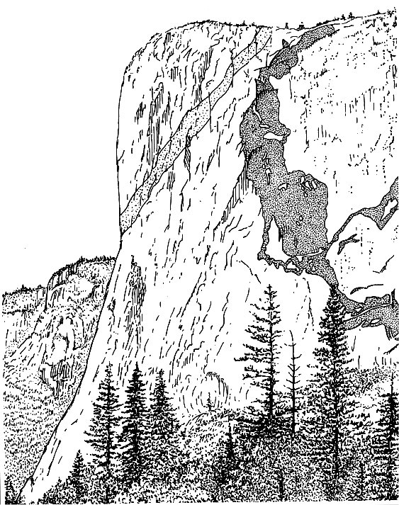
monoliths of Turtleback Dome, El Capitan, Three
Brothers, and Cathedral Rocks also are hewn chiefly
from massive El Capitan Granite.
After the El Capitan Granite was emplaced, the Taft
Granite welled up and intruded the El Capitan. Dikes
of Taft Granite invading El Capitan Granite and inclusions
of El Capitan in Taft establish the Taft as
younger. The two rocks are similar, but Taft Granite is
lighter in color and commonly finer grained than El
Capitan Granite and, unlike El Capitan Granite, generally
does not contain phenocrysts. Taft Granite forms
the brow of El Capitan and part of the upland between
El Capitan and Fireplace Bluffs. On the south side of
the valley, Taft Granite can be seen at Dewey Point and
near The Fissures, just east of Taft Point.
In the vicinity of Leaning Tower and Cathedral
Rocks, dikes and irregular masses of several fine-grained
rocks cut the Taft and El Capitan Granites. Examples
of these fine-grained rocks can be seen in blocky rubble
near the base of Bridalveil Fall. The Leaning Tower
Granodiorite characteristically contains rounded clots
of dark minerals that give it a spotted appearance
(fig. 11C).
The Bridalveil Granodiorite, which contains
fine, evenly distributed, light and dark minerals, has
a salt-and-pepper appearance
(fig. 11D);
features seen
in outcrop show that it intruded nearly all the rocks
which it now contacts.
Dark, fine-grained diorite also intrudes the El
Capitan and Taft Granites. A striking example is
exposed on the east face of El Capitan, where dikes
of diorite form an irregular pattern that, in part, very
crudely resembles a map of North America
(fig. 19).
The Sentinel Granodiorite forms a north-south band
that crosses the valley between Taft Point and Glacier
Point. The rock varies in appearance but is generally
medium gray and medium grained
(fig. 11B).
Giant
inclusions of El Capitan Granite are embedded
within Sentinel Granodiorite in a zone that extends
along Yosemite Creek and down the face of the cliff
near Yosemite Falls. The Sentinel Granodiorite reappears
on the south valley wall west of Union Point
and then extends southward through Sentinel Dome
to Illilouette Ridge. Dikes of Sentinel Granodiorite
[click to enlarge]
|
DIORITE DIKES on the face of El Capitan; dark patch is
thought by some to resemble a crude map of North America.
Some lighter colored dikes are also present.
(Fig. 19)
|
that cut inclusions of El Capitan Granite can be seen
in the roadcut along the Glacier Point Road near the
trailhead to Taft Point.
The rock at Glacier and Washburn Points is darker
than Sentinel Granodiorite and has a streaky
appearance from parallel-oriented flakes of biotite
and rods of hornblende. This darker rock, once
thought to be part of the Sentinel and shown as such
on earlier geologic maps, is now assigned to the
granodiorite of Kuna Crest.
The Half Dome Granodiorite dominates the valley
area east of Royal Arches and Glacier Point. It is
medium to coarse grained and contains well-formed
plates of biotite and rods of hornblende
(fig. 11A).
At Church Bowl and in the cliff west of Royal
Arches, horizontal dikes of Half Dome Granodiorite
cut the older granodiorite of Kuna Crest. Half Dome
Granodiorite forms the sheer cliffs to the north of
the trail between the Ahwahnee Hotel and Mirror
Lake. The trail to Vernal and Nevada Falls also
crosses through Half Dome Granodiorite. Except for
minor dikes, the Half Dome Granodiorite, about 87
million years old, is the youngest plutonic rock in
the valley area.
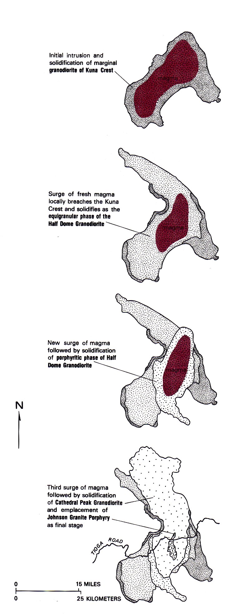
TUOLUMNE MEADOWS AREA
The granodiorite of Kuna Crest and the Half Dome
Granodiorite exposed at the east end of Yosemite Valley
are two plutonic-rock units that make up the western
margin of the Tuolumne Intrusive Suite. This suite
underlies a large part of eastern Yosemite National Park
from upper Yosemite Valley, across Tuolumne Meadows
eastward to the crest of the Sierra, and northward
beyond the park boundary (pl. 1). The Tuolumne
Intrusive Suite, one of the best studied groups of
granitic rocks in the Sierra, consists of four bodies of
plutonic rock, sequentially emplaced and partly nested
one within the other
(fig. 20).
The suite is well exposed
in the area centered on Tuolumne Meadows, and the
Tioga Road (Route 120) provides access to many conspicuous
outcrops of the suite’s components.
The oldest and darkest plutonic rock generally forms
the margin of the suite, and the youngest rock is in its
core. The rocks are, from oldest to youngest: the
granodiorite of Kuna Crest (about 91 million years old),
the Half Dome Granodiorite, the Cathedral Peak
Granodiorite (about 86 million years old), and the
Johnson Granite Porphyry. Field relations indicate that
the Johnson Granite Porphyry is the youngest granitic
rock in the park, although a radiometric age has not
yet been determined. The granodiorite of Kuna Crest
normally occupies the margin of the suite, but on much
of the perimeter the Half Dome Granodiorite and the
Cathedral Peak Granodiorite have broken through the
granodiorite of Kuna Crest to form the marginal units
(fig. 20).
The overall concentric zonation of rock bodies
within the suite, as well as the overall chemical similarities
among the rocks, suggests that these rocks
originated from the same magma chamber. This inferred
common parentage provides the rationale for grouping
these rocks into an intrusive suite. The composition
of the magma, however, changed over time: the older,
hornblende- and biotite-rich rocks at the margins give
way to quartz- and potassium feldspar-rich rocks toward
the center. Hornblende and biotite crystallize at higher
temperatures than quartz and feldspar, and so during
cooling of a magma, these dark minerals generally
crystallize earlier than the light-colored ones. This
relation suggests that cooling of the magma started at
the margins and progressed inward over time.
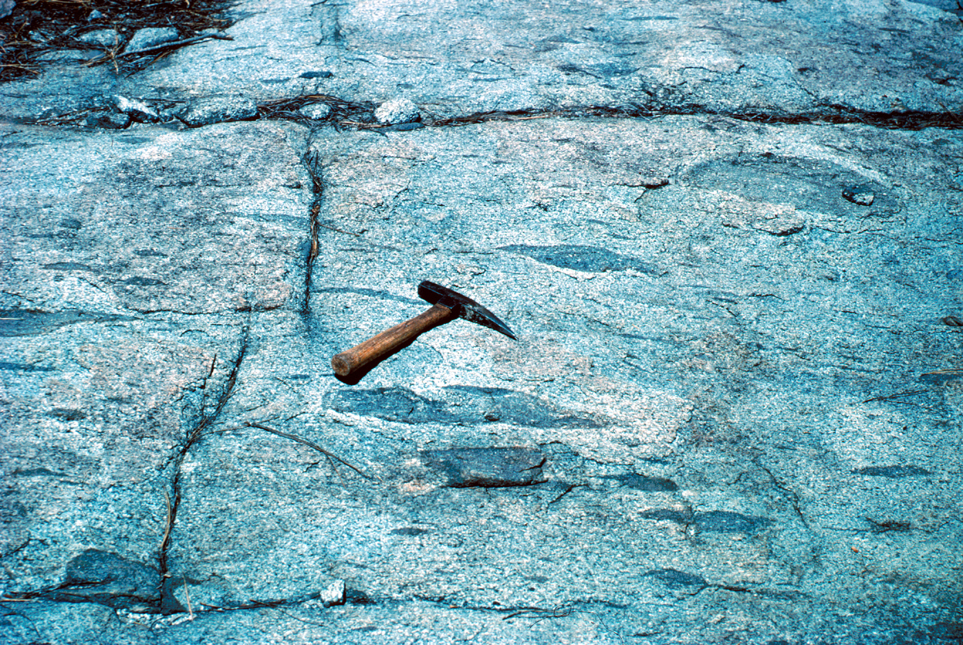
North of the Tioga Pass Entrance Station, the trail
to Gaylor Lakes crosses over the granodiorite of Kuna
Crest, the oldest and darkest rock in the Tuolumne
Intrusive Suite. This trail weaves back and forth near
the contact between the granodiorite and the metamorphic
rocks that it intruded. The granodiorite also
contains many disc-shaped inclusions that are oriented
parallel to its contact with the older metamorphic
rocks. These inclusions were probably stretched and
oriented by movement within the magma during intrusion
and cooling.
The Half Dome Granodiorite, the next youngest
rock in the suite, is in contact with the granodiorite of
Kuna Crest to the west along the ridge crossed by the
Gaylor Lakes Trail. The best exposures of the Half
Dome, however, are surrounding the turnout at
Olmsted Point west of Tenaya Lake. Fresh, clean outcrops
of the rock abound at and across from the
turnout. Half Dome Granodiorite makes up much of
the southwestern part of the Tuolumne Intrusive Suite
and in several areas is the marginal rock.
Heading east toward Tuolumne Meadows, the Tioga
Road crosses the contact between the Half Dome
Granodiorite and the Cathedral Peak Granodiorite just
east of Tenaya Lake. The contact is obscure, however,
because here the Half Dome contains nearly as many
potassium feldspar phenocrysts as does the younger
Cathedral Peak. Pothole and Lembert Domes, both
marginal to the meadows, are composed entirely of
Cathedral Peak Granodiorite. The rock of these domes
clearly displays potassium feldspar phenocrysts, commonly
as much as 2 to 3 in. long
(fig. 14).
These
impressive crystals stand out against a medium-grained
background. The Cathedral Peak Granodiorite forms
the largest pluton of the Tuolumne Intrusive Suite,
extending long distances to the north and south of
Tuolumne Meadows.
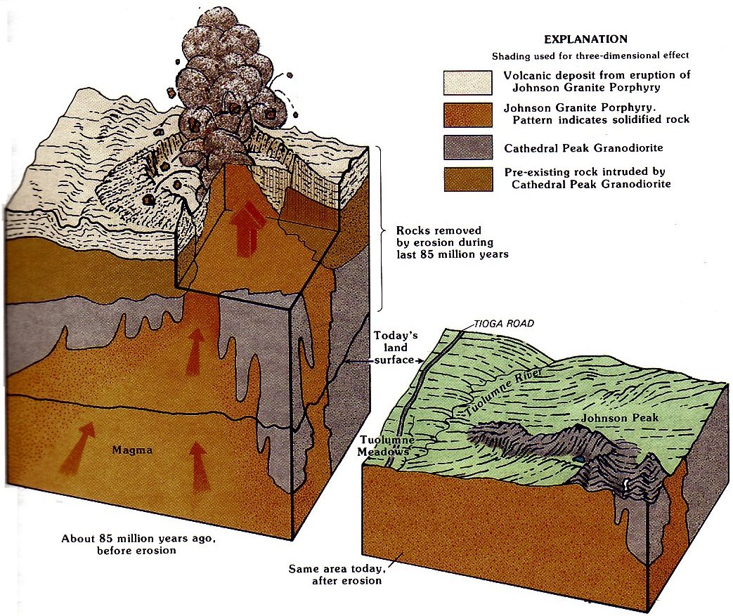
The youngest, smallest, and most central rock body
if the suite is composed of the Johnson Granite Porphyry.
In a porphyry, the conspicuous phenocrysts are
set in a finer grained matrix than in such porphyritic
rocks as the Cathedral Peak Granodiorite, and so
individual mineral grains in the matrix are difficult to
identify without a microscope. Low outcrops of the
porphyry can be seen in Tuolumne Meadows along
the Tuolumne River, across from the store, and east
of Soda Springs on the north side of the river. The
rock is very light colored, with only a few scattered
potassium feldspar phenocrysts within a fine-grained
matrix
(fig. 21).
Dikes of Johnson Granite Porphyry
intrude Cathedral Peak Granodiorite, and the porphyry
itself is cut by light, fine-grained aplite dikes.
[click to enlarge]
|
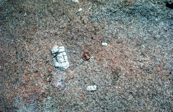
JOHNSON GRANITE PORPHYRY, showing potassium
feldspar phenocrysts set in a fine-grained matrix.
(Fig. 21)
|
The fine-grained matrix of a porphyry requires that
partially crystallized magma be quenched or cool relatively
quickly. Such conditions would result from a
sudden release of pressure, as would occur if some of
the magma were erupted at the Earth’s surface. Thus,
volcanic eruptions probably accompanied final
emplacement of the Tuolumne Intrusive Suite—a volcanic
caldera may once have existed far above what is
now Johnson Peak
(fig. 22).
[click to enlarge]
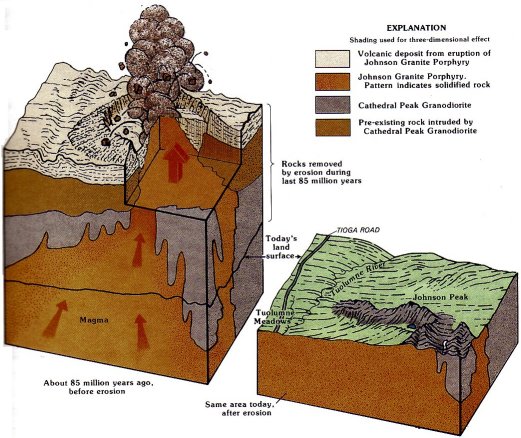
|
FINAL STAGES
IN THE EVOLUTION
OF THE
TUOLUMNE INTRUSIVE
SUITE.
The Johnson Granite Porphyry
intrudes the Cathedral
Peak Granodiorite
and erupts through a volcanic
caldera, spewing
volcanic ash and debris
onto the Earth’s surface.
The volcanic deposit and
much of the underlying
rock are subsequently
removed by erosion to
create today’s land surface.
(Fig. 22)
|
METAMORPHIC ROCKS—ANCIENT
SEDIMENT AND LAVAS
Metamorphic rocks are derived from preexisting
rocks by mineralogic and structural changes in response
to increases in temperature, pressure, and shearing
stress at depth within the Earth’s crust. In the Sierra
Nevada, some of this heat and pressure was supplied by
the intruding granitic rocks, but much of it was
imposed simply by depressing sedimentary and volcanic
rocks once exposed at the Earth’s surface downward to
depths where higher temperature and pressure are the
normal environment. The metamorphic rocks in the
Yosemite area were derived from a great variety of
sedimentary and volcanic rocks and thus exhibit a great
variety in themselves. Some rocks have been only
mildly metamorphosed and still retain original structures,
such as sedimentary layering, that help to identify
the nature of the original rock. Others have been
so strongly deformed and recrystallized that original
textures and structures have been destroyed, and determination
of the original rock type is difficult.
Metamorphosed sedimentary rocks in the Yosemite
area include rocks that were originally sandstone and
siltstone, conglomerate, limestone, shale, and chert.
Metamorphosed volcanic rocks in the Yosemite area
include those derived from lava flows and various types
of pyroclastic rocks—those formed from violently
erupted volcanic debris.
The rocks into which the Sierra Nevada batholith
was emplaced are weakly to strongly metamorphosed,
mildly to complexly deformed strata of probable Paleozoic
and Mesozoic age. In the Yosemite area these
metamorphic rocks occur in two northwest-trending
belts situated largely east and west of the park proper
and in small isolated bodies scattered throughout the
park. Fossils are scarce, and the radiometric ages of
most of these rocks are poorly known.
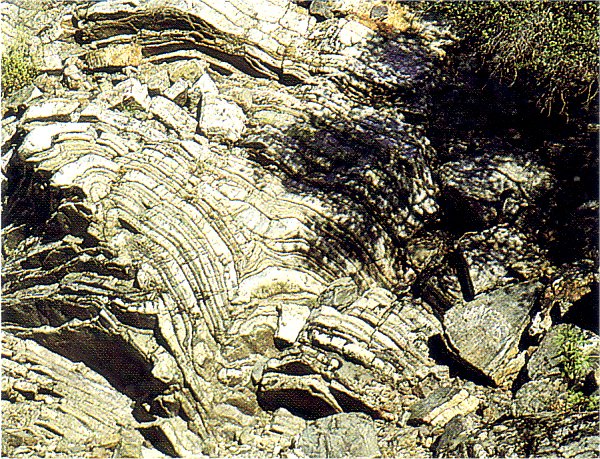
Rocks of the western metamorphic belt underlie
much of the foothills of the western Sierra between the
San Joaquin and Feather Rivers, and form the western
wallrocks of the Sierra Nevada batholith. In the canyon
of the Merced River approaching Yosemite on
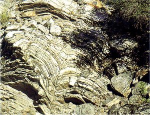
Route 140, strikingly banded chert is exposed in the
vicinity of the “geological exhibit” and eastward for
several miles
(fig. 23).
This banded chert was formed
from the skeletons of very tiny, silica-secreting marine
animals called radiolarians; upon the death of such
animals, their skeletons settle to the ocean bottom,
where they collect in enormous numbers. Although the
chert beds are moderately to strongly deformed, the
[click to enlarge]
|
CONTORTED CHERT BEDS along the Merced River west
of El Portal are ancient marine sediment that has been
metamorphosed.
(Fig. 23)
|
rock is easily recognizable as of sedimentary origin. In
contrast, metamorphic rocks just west of El Portal and
just west of Crane Flat along the Big Oak Flat Road
(Route 120) have a metamorphic layering that largely
destroys original bedding, and the origin of these rocks
as sediment is less obvious. Fossils in a limestone bed
just west of the “geological exhibit” on Route 140
indicate a Triassic age for at least some of the rocks
exposed along this part of the Merced River canyon.
The eastern belt of metamorphic rocks extends for
about 50 mi from south of Mammoth Lakes to north of
Twin Lakes (pl. 1). Furthermore, rather than bounding
the batholith, this belt is a giant septum of metamorphic
rocks separating plutonic rocks on either side.
This eastern belt includes rocks of both sedimentary
and volcanic origin, which range in age from early
Paleozoic to late Mesozoic. The Paleozoic rocks are
metasedimentary and include such varieties as
quartzite, metaconglomerate, and marble. The commonest
rock, however, is homfels—a catchall term for
a fine-grained metamorphic rock composed of a mosaic
of equidimensional grains formed by recrystallization of
sedimentary and volcanic rocks of various compositions.
These Paleozoic rocks are well exposed along
Route 120 near Ellery Lake east of Tioga Pass.
The Mesozoic rocks of the eastern metamorphic belt
are chiefly of volcanic origin—tuff and other
explosively ejected fragmental volcanic rock—with
lesser amounts of sedimentary rock. These Mesozoic
rocks, which lie generally west of the Paleozoic rocks in
the eastern metamorphic belt, make up the Ritter
Range and the southeastern margin of the park, and
much of the Sierran Crest northward through Kuna
Peak, Mount Dana, Gaylor Peak, and continuing north
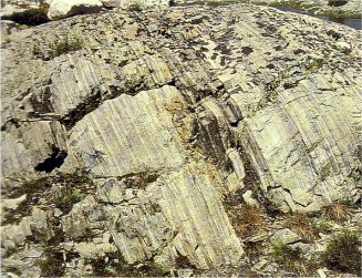
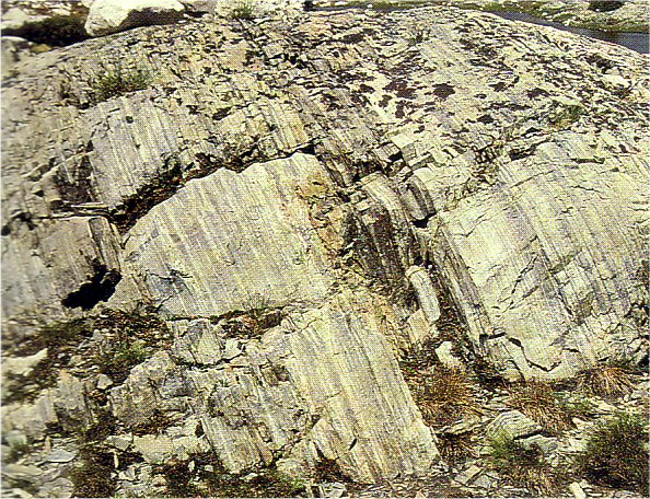
of the park beyond Twin Lakes (pl. 1). Relict sedimentary
bedding is commonly preserved—steeply dipping,
as west of Saddlebag Lake, or highly contorted, as near
Spotted Lakes at the south end of the park
(fig. 24).
Of particular interest are the little-deformed metamorphic
rocks of Cretaceous age. Metamorphosed volcanic
rocks near the summit of Mount Dana have a
radiometric age of about 118 million years, and those
from the Ritter Range of about 100 million years,
which means that their eruption from volcanoes
occurred at the same time that some of the smaller
plutonic-rock suites were emplaced at depth. In the
Ritter Range, a thick deposit of volcanic breccia has
been interpreted as resulting from collapse of an
ancient volcanic caldera.
[click to enlarge]
|

[click to enlarge]
|
|
METAMORPHIC ROCKS with relict sedimentary bedding.
A, Steeply dipping, as northwest of Saddlebag Lake. B, Highly
contorted, as near Spotted Lakes. Photograph by John P. Lockwood.
(Fig. 24)
|
Late Cenozoic Volcanic Rocks—
Born of Fire
Volcanic rocks, like their plutonic counterparts, are
also classified on the basis of composition. Because
volcanic rocks erupted onto the Earth’s surface cool and
solidify more quickly than plutonic rocks, they tend to
be finer grained or even glassy, with few minerals
identifiable to the eye. Those few visible minerals,
however, are guides to the rock’s composition. Late
Cenozoic volcanic rocks in Yosemite have a very limited
range in composition; they generally contain little
or no quartz and range from basalt and andesite (containing
little or no potassium feldspar) to latite (containing
both potassium and plagioclase feldspar). A
volcanic rock containing quartz—rhyolite—does occur
just east of Yosemite at the Mono Craters.
Late Cenozoic volcanic rocks of the Yosemite area
formed both by the eruption of vast volumes of lava
and by much smaller eruptions. The products of great
eruptions extend into the northern part of the park but
are much more extensive in the northern Sierra; they
include lava flows, tuff, and volcanic mudflows. Details
of the nature and distribution of all these volcanic
rocks are deferred to the
section dealing with the late
Cenozoic.
PLATE TECTONICS
A DYNAMIC GLOBE
|
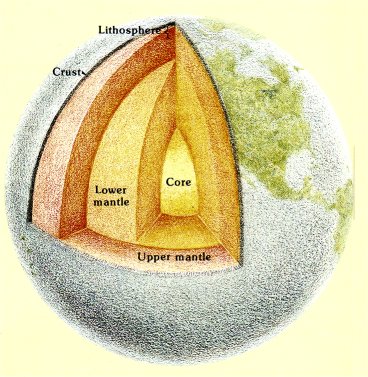
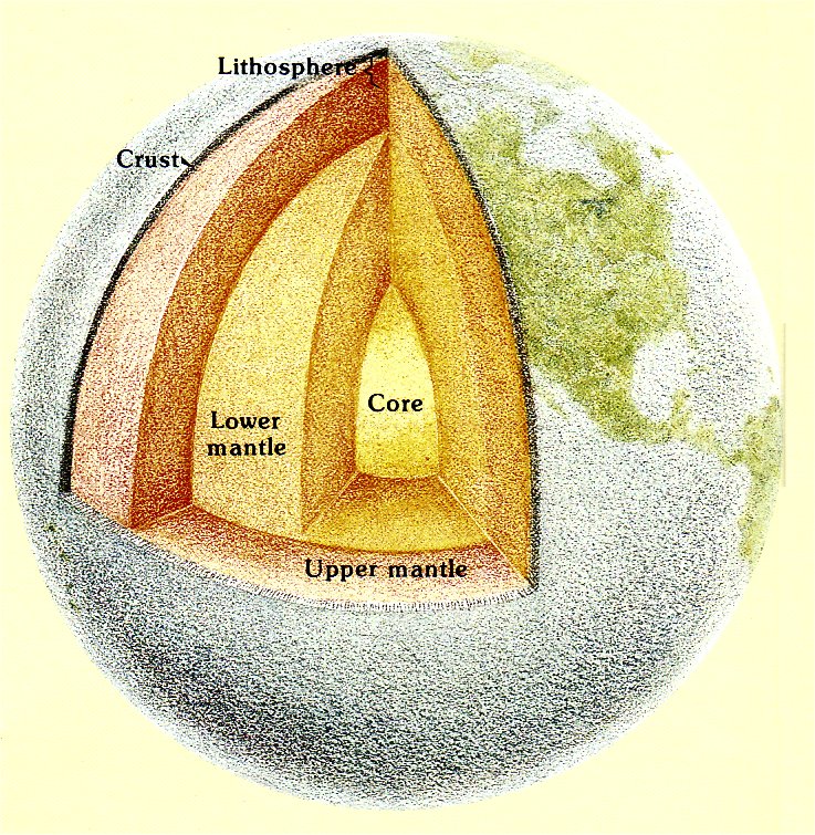
The Earth is generally depicted as consisting of a
series of concentric shells—a relatively thin outer
crust, an intermediate mantle, and an interior core
(fig. 25).
The Earth’s crust and uppermost part of the
upper mantle together form the rigid outer part of the
Earth—the lithosphere—which is broken into plates
that ride over a less rigid, viscous layer within the
upper mantle that yields plastically. There are seven
very large plates, and a dozen or so small ones
(not all of which are shown in fig. 26.)
The large plates
consist of both oceanic and continental portions; the
present North American plate, for example, includes
not only the North American Continent but Greenland
and the west half of the North Atlantic Ocean
as well. The crust beneath continents is typically 20
to 34 mi thick and is less dense than the crust
beneath oceans, which typically is only 4 to 5 mi
thick. The plates generally are internally rigid, and
most dynamic geologic activity is concentrated
along the plate boundaries; these boundaries are
marked by long, narrow belts of earthquake and
volcanic activity.
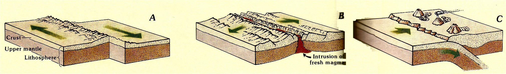
Each of the plates is moving relative to all the
others. In the simplest mode, two plates slide past
each other along a strike-slip fault
(fig. 27A).
The San
Andreas fault, running much the length of California
and forming part of the present boundary between
the North American and Pacific plates, is an example.
Where plates move away from each other, primarily
along the system of great submarine ridges
in the world’s oceans, hot material wells up from
below to fill the gap
(fig. 27B).
As this hot material
cools to form basalt, it becomes attached to the
plates on either side of the spreading zone, and new
crust is created. Where plates converge, one tips
downward and slides beneath the other— a process
called subduction
(fig. 27C).
Generally, a plate with
dense oceanic crust slides beneath one with more
bouyant continental crust. Thus, new oceanic crust
created at spreading centers is recycled back into
the Earth’s interior through subduction, and and the
total surface area of the Earth remains unchanged.
|
[click to enlarge]
|
INTERIOR OF THE EARTH, showing relation of
crust and
mantle to the rigid lithosphere—the stuff of
which the mobile
plates are made.
(Fig. 25)
|
|
MAJOR LITHOSPHERE PLATES OF THE
WORLD, showing boundaries that are presently active. Double
One, zone of spreading, from which plates are moving apart;
barbed line, zone of underthrusting (subduction), where one plate
s sliding beneath another—barbs on overriding plate; single line,
strike-slip fault, along which plates are sliding past one another.
See
figure 27
for examples of plate motions.
(Fig. 26)
THREE PRINCIPLE KINDS OF PLATE MOTION.
A, The plates slide past each other along a strike-slip fault. B,
The plates move away from each other at a divergent boundary. C,
The plates move toward each other at a convergent boundary; the
process of subduction consumes crust at convergent plate boundaries.
(Fig. 27)
|
Next: Genesis of Yosemite’s rocks
•
Contents
•
Previous: Geologic overview
http://www.yosemite.ca.us/library/geologic_story_of_yosemite/rocks.html


![[click to enlarge]](images/18.jpg)