[click to enlarge] |
[click to enlarge]
| Online Library: | Title | Author | California | Geology | History | Indians | Muir | Mountaineering | Nature | Management |
Yosemite > Library > Geologic Story of Yosemite > Final evolution of the landscape >
Next: Terms • Contents • Previous: Genesis of Yosemite’s rocks
The bedrock structures having the greatest effects on Yosemite’s landform development are joints. Joints are more or less planar cracks commonly found as sets of parallel fractures in the rock. Regional-scale joints commonly determine the orientation of major features of the landscape, whereas outcrop-scale joints determine the ease with which rock erodes. Joints are of overwhelming influence on landform development in granitic terrane because they form greatly contrasting zones of weakness in otherwise homogeneous, erosion-resistant rock and are avenues of access of water and air for weathering. In metamorphic rocks, such planar structures as bedding or aligned minerals commonly determine the orientation of fractures.
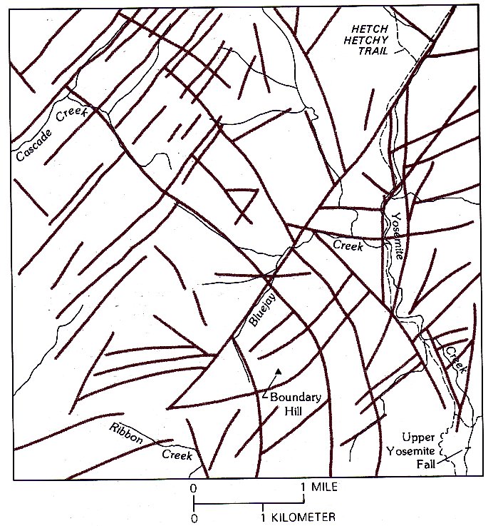
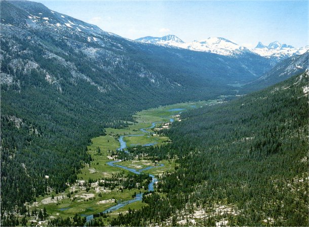
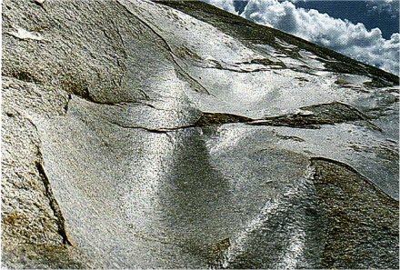
REGIONAL JOINTS
emphasized by vegetation, as
seen on an aerial photograph—
Yosemite Creek
basin north of Yosemite Valley.
Northeast-trending joint
set is more closely spaced
than northwest-trending set.
Sparser, east-west-trending
set is also present. Accompanying
sketch map shows
orientation of major joints
and illustrates the significant
control of stream courses by
joints.
(Fig. 33)
|
[click to enlarge] |
A regional system of widely spaced master joints is conspicuous throughout the granitic terrane, particularly in the High Sierra where rock exposures are extensive. These joints generally are nearly vertical and are not to be confused with the gently dipping sheet joints that are subparallel to topographic surfaces. Linear depressions commonly follow the master joints, and even in highly dissected regions, straight segments of streams are joint controlled. Generally, two principle sets of joints can be identified nearly at right angles, one set commonly trending northeast and the other northwest (fig. 33). The orientation changes from place to place, but most joints are straight or only gently curved. Some individual joints can be traced for many miles. The continuity of joint sets across the boundaries between individual granitic plutons indicates that the joints formed after consolidation of the entire batholith and thus are not cooling fractures of the individual bodies. The regional joint system evidently resulted from stresses imposed on the batholith during later tectonic events, such as tilting of the Sierra region.
Some movement other than simple opening along the joint planes has probably taken place along most of the master joints. Such lateral, or fault, movement, even though slight, would crush or break rock along the joint. Deep weathering and erosion along these Danes of broken rock form long, linear depressions, many of them now channels for streams. Areas of granite within blocks bounded by master joints are themselves jointed to a lesser degree hut remain more cohesive and form the bolder areas between master joints.
[click to enlarge] |
|
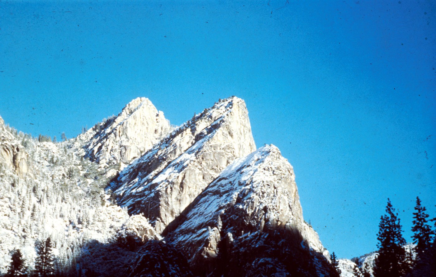
INCLINED JOINTS determine westward slope of upper surfaces
of the Three Brothers. Photograph from National Park Service collection. (Fig. 34) |
[click to enlarge] |
|
STAIRCASE FALLS. Stairtreads follow joints inclined
eastward. Photograph by Tau Rho Alpha. (Fig. 35) |
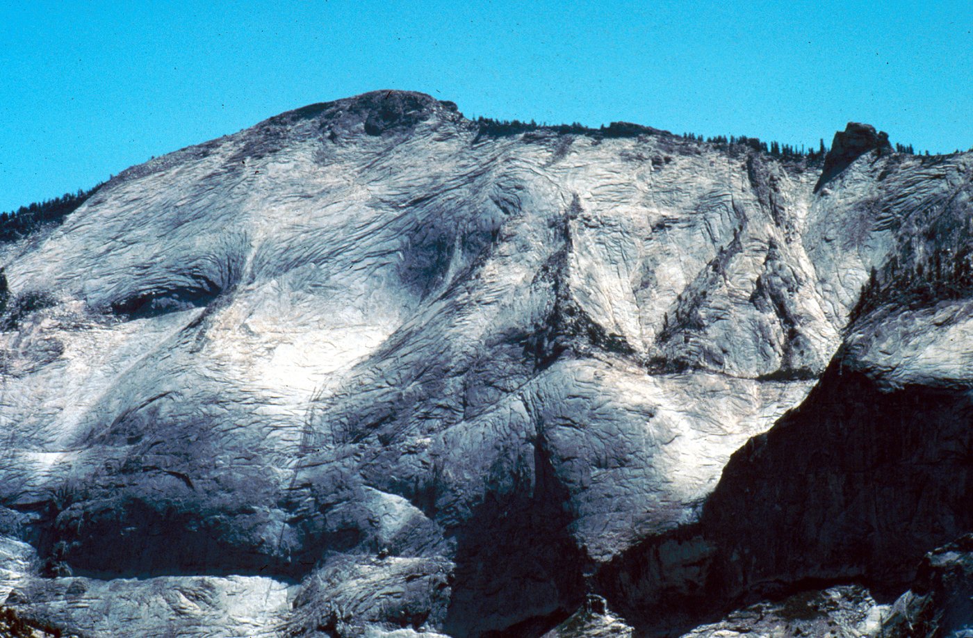
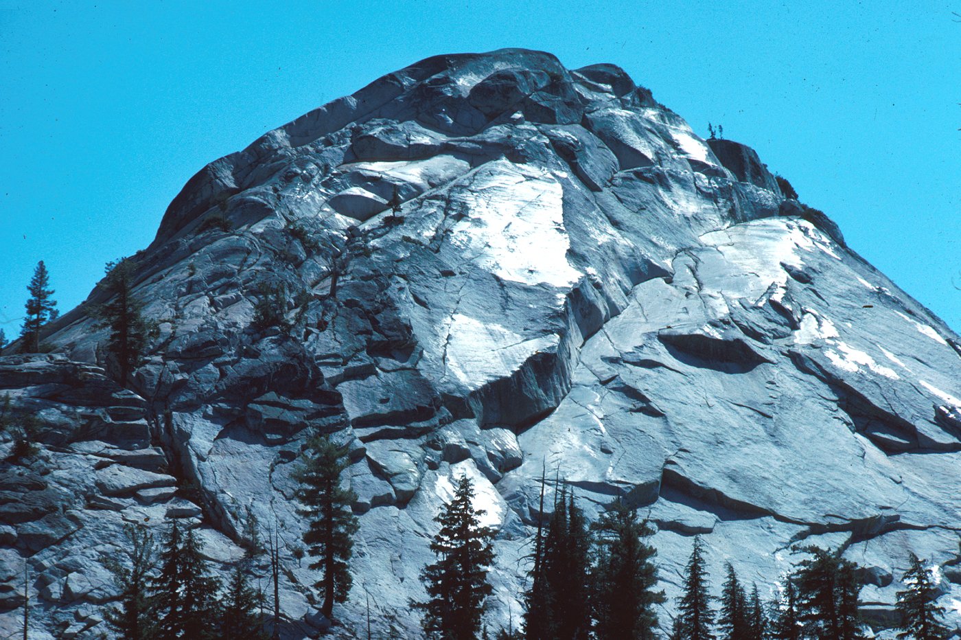
On a more local scale, vertical joint sets are responsible for the orientation of major features, such as the planar face of Half Dome and the series of parallel cliffs at Cathedral Rocks. An individual cliff face itself may not be the original controlling joint surface, because material is continually spalling off, but its orientation is controlled by a preexisting joint.
Although vertical master joints prevail, inclined joint sets have added to the diversity of Yosemite’s landforms. The west faces of the Three Brothers in Yosemite Valley were largely determined by a set of master joints that slope about 45° westward (fig. 34). The slope between Cathedral Rocks and Bridalveil Creek also follows a set of westward-inclined joints. The stairtreads of Staircase Falls follow east-dipping joints (fig. 35).
[click to enlarge] |
|
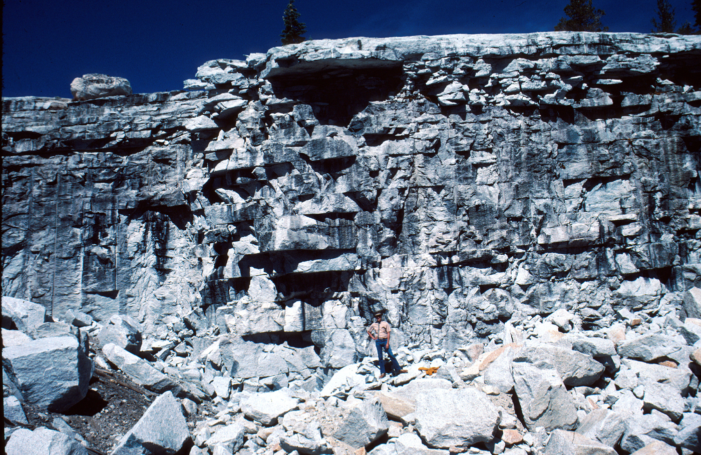
RECTANGULAR BLOCKS formed in El Capitan Granite
by intersecting joints. (Fig. 36) |
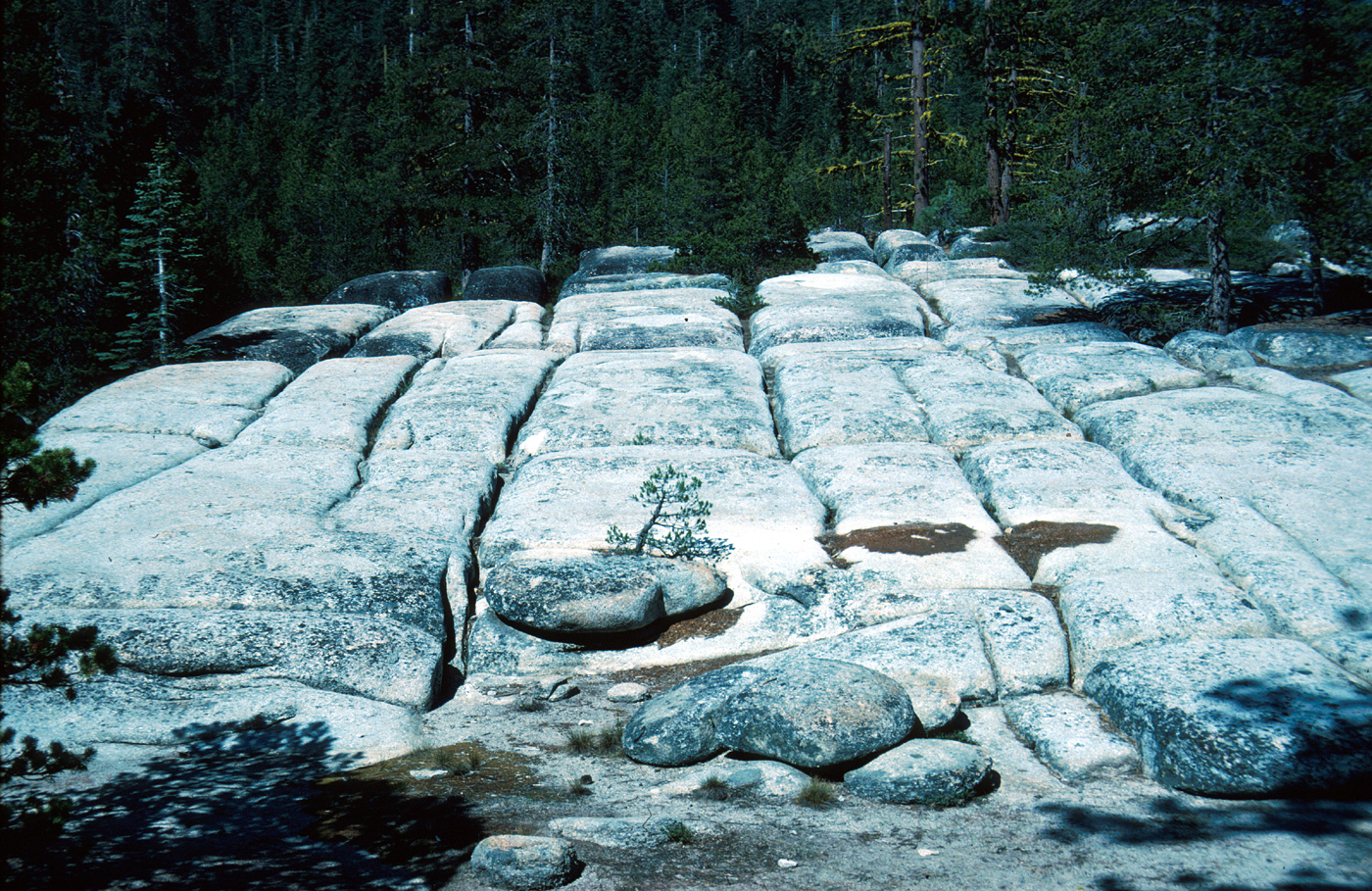
At outcrop scale, two nearly vertical joint sets, perpendicular to each other, combine with nearly horizontal joints to create approximately rectangular blocks (fig. 36). Generally, the more siliceous, or quartz-rich, rocks (granite and granodiorite) have more widely spaced joints than the less siliceous rocks (tonalite and diorite). Also, the finer grained rocks generally have more closely spaced joints than the coarser grained ones. Thus, both composition and texture influence the spacing of joints in a given rock mass.
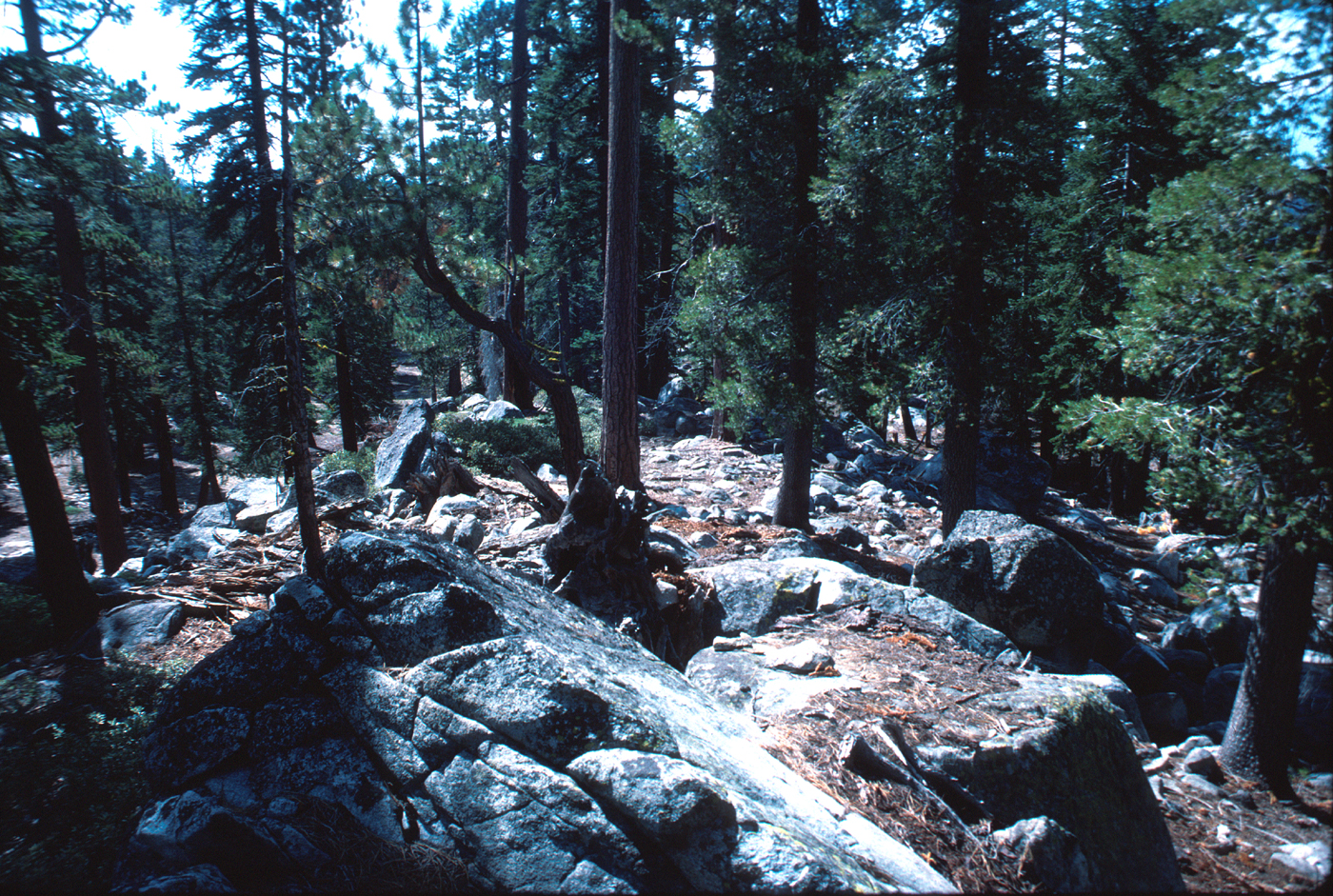
The least siliceous of the plutonic rocks in Yosemite Valley, for example, is the diorite that occurs at the Rockslides; this rock is also generally finer grained than most of the granitic rocks. The diorite is the most closely jointed rock in the valley, and enormous piles of joint-derived blocks of diorite have accumulated throughout the area of the Rockslides (fig. 37).

[click to enlarge] |
| THE ROCKSLIDES AND EL CAPITAN. The Rockslides (left) is a jumbled collection of talus blocks of diorite, the most closely jointed rock in Yosemite Valley. In contrast, El Capitan (right) is largely unjointed granite, and the pile of debris at its foot, though concealed in this photograph, is comparatively small. (Fig. 37) |
In a particularly striking contrast to the jumbled piles of debris at the Rockslides is the largely unbroken face of El Capitan, a short distance to the east—one of the sheerest cliffs in the world. It consists chiefly of El Capitan and Taft Granites, two of the most siliceous plutonic rocks in this area. The composition of these rocks determines the characteristics of El Capitan itself—massiveness and resistance. Because El Capitan is largely unjointed, the talus pile at its foot is small. Cathedral Rocks and the Leaning Tower are composed of El Capitan Granite, complexly intruded by Bridalveil Granodiorite; these pinnacles stand out as they do because of their siliceous composition.
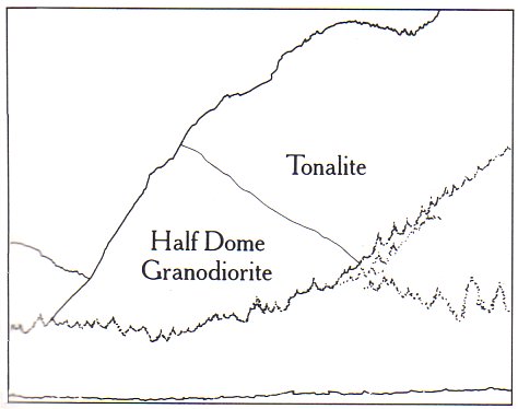
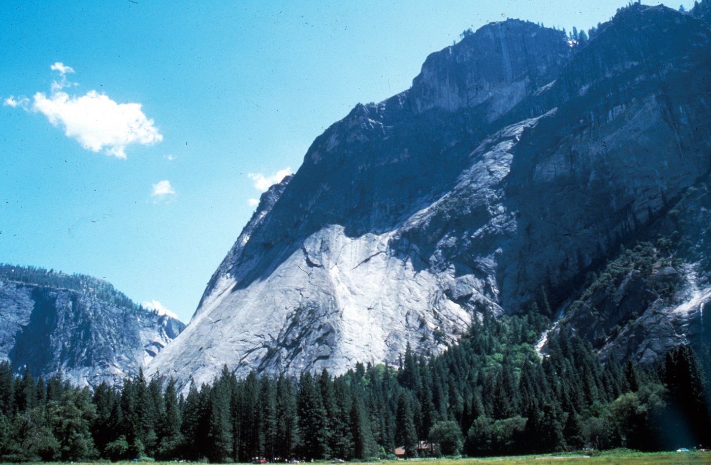
The apron or lower part of the cliff east of Glacier Point consists of unjointed Half Dome Granodiorite capped by well-jointed tonalite; from a viewpoint in Stoneman Meadow, an observer, by noting this difference in structure, can trace the contact between the two rock types quite closely (fig. 38).
[click to enlarge] |
[click to enlarge] |
| BOLD EXPOSURE of unjointed Half Dome Granodiorite (in sun) capped by mostly well-jointed tonalite (in shade) making up Glacier Point. The contact between the two rock types angles upward to left. (Fig. 38) |
So mammoth a feature as Half Dome could only have been carved from a sparsely jointed rock. In spite of James Hutchings’ eloquent statement accompanying the frontispiece to this volume, Half Dome is nearly as whole as it ever was. The impression from the valley floor that this is a round dome which has lost its northwest half is an illusion. From Glacier Point or, even better, from Washburn Point, we can see that it is actually a thin ridge of rock oriented northeast-southwest, with its southeast side almost as steep as its northwest side except for the very top. Although the trend of this ridge, as well as that of Tenaya Canyon, is probably controlled by master joints, 80 percent of the northwest “half” of the original dome may well still be there. What probably happened is that frost splitting of the rock at the back of a tiny glacier against Half Dome above Mirror Lake gradually quarried back the steep northwest face. As the base of the cliff was hewn away, ultimately parts of the sheets parallel to the original upper surface of Half Dome were left projecting outward at the crest of the vertical cliff. Sharp angular bends in the gross form of Yosemite Valley suggest that the entire valley, as well as Tenaya Valley, may have been eroded along a complex joint system now concealed by stream deposits on the valley floor.
[click to enlarge] |
|
PROGRESSIVE ROUNDING OF MASSIVE GRANITE
as successive sheets (dashed lines) are formed and spalled off in response to unloading, or release of the confining pressure under which the granite crystallized deep within the Earth. This is a form of exfoliation. (Fig. 39) |
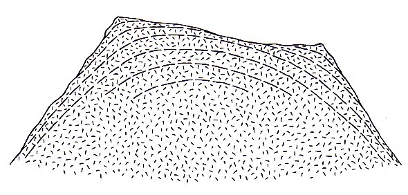
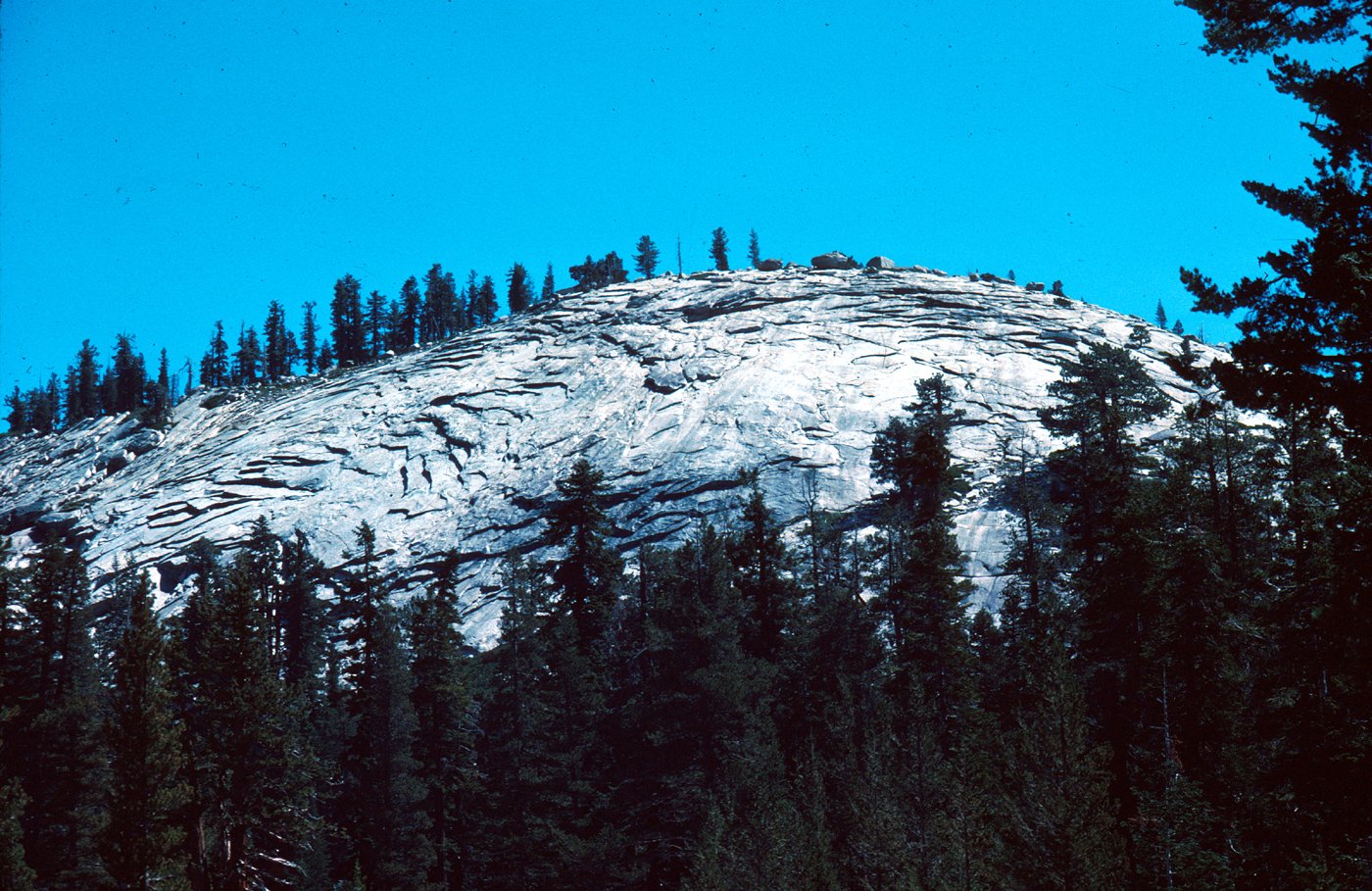
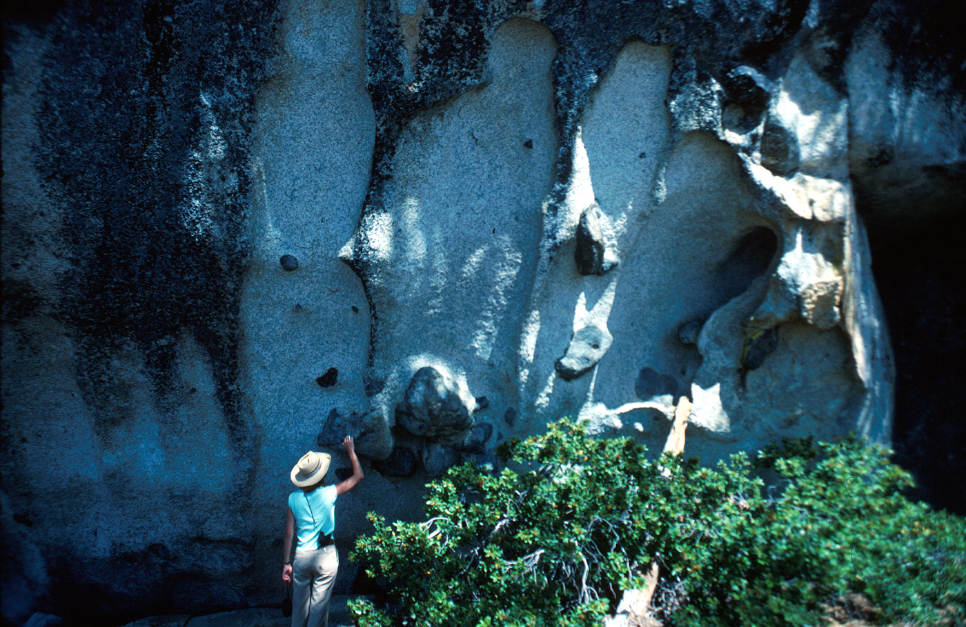
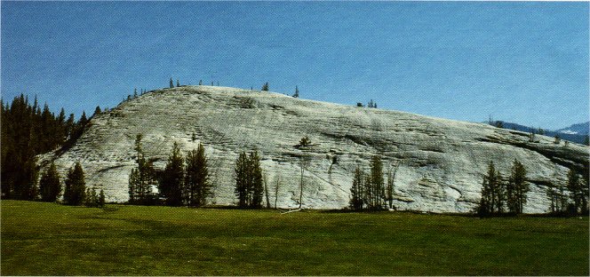
The type of jointing that has most influenced the form of Yosemite’s landmarks, however, is the broad, shell-like unloading joints or sheeting, also commonly referred to as exfoliation. Granitic rocks crystallize at considerable depth within the Earth while under great pressure from miles of overlying rock. As the still-buried plutonic rocks are uplifted into mountains and the overlying rock is eroded, the unloading, or release of the previously confining pressure, causes the rock to expand toward the Earth’s surface. In jointed rocks, such expansion is taken up by adjustments along the numerous partings; but in a massive monolith, the stresses accumulate until they exceed the tensile strength of the rock, and the outer and more rapidly expanding layer bursts loose. Over time, the process is repeated, and the monolith becomes covered with several layers of shells. The outermost layer, exposed to the weather, gradually disintegrates, and the pieces fall off. The process of sheeting eliminates projecting corners and angles and replaces them with curves (fig. 39). As succeeding shells drop off, these curves become more and more gentle, and thus a smoothly rounded surface evolves.
[click to enlarge] A |
[click to enlarge] B |
[click to enlarge] C |
[click to enlarge] D |
| SHEET JOINTS FOLLOW TOPOGRAPHIC SURFACES. A, Horizontal sheeting exposed on quarry face, cut into broad, level surface. B, Convex sheeting on granite dome. C, Concave sheeting on valley floor. D, Near-vertical sheeting on Matthes Crest. Unloading has taken place from both sides of a steep linear ridge. Photograph from National Park Service collection. (Fig. 40) | |
Because the expansion that forms sheet joints takes place perpendicular to the Earth’s surface, the shape of sheets generally reflects the topography, although their formation subtly modifies the topography at the same time. If the ground surface is level, the sheets will be horizontal (fig. 40A). If the granite underlies a hill, the sheets will curve accordingly, convex upward (fig. 40B); and if beneath a valley, concave upward (fig. 40C). Sheeting also tends to parallel the walls of canyons. If the canyon wall slopes toward the river, the sheets do also. If the walls are vertical, the sheets are also vertical (fig. 40D); thus, the vertical cliffs of Yosemite that appear to be unbroken monoliths may have hidden vertical fractures behind and parallel to the cliff face. The undulating surface of the wall below Clouds Rest is an outstanding example of sheeting that parallels the topographic surface; the sheets are concave in the bowl-shaped basins high on the cliff face and convex on the intervening spurs (fig. 41).
| UNDULATING SURFACE below Clouds Rest. The sheet joints are concave in the bowl-shaped basins high on the cliff face, and convex on the intervening spurs. (Fig. 41) |
[click to enlarge] |
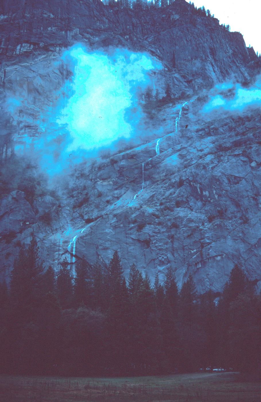
The Royal Arches is a gigantic expression of sheet jointing, with sheets as much as 200 ft thick (fig. 42). Too far below the surface to form the tops of domes, the arches reveal a cross- sectional view of sheet jointing in Half Dome Granodiorite that has been truncated by the north wall of Yosemite Valley. Similar features can also be seen on the walls behind Upper Yosemite Fall and at the head of Ribbon Fall alcove.
| ROYAL ARCHES, in left center of photograph and topped by North Dome, is a gigantic expression of sheet joints, with sheets truncated by north wall of Yosemite Valley. Photograph by Eadweard Muybridge, about 1872. (Fig. 42) |
[click to enlarge] |
[click to enlarge] |
|
WEATHERING OF JOINT BLOCKS and stages in the
formation
of corestones. Corners and edges of granite blocks are attacked more readily by weathering along joints, and rounded corestones result. (Fig. 43) |
[click to enlarge] |
|
SPHEROIDAL WEATHERING around corestones. Rectangular
pattern of sheets reflects horizontal and vertical orientation of joints originally bounding the disintegrating blocks Roadcut at Big Meadow overlook, Big Oak Flat Road (Fig. 44) |
INFLUENCE OF THE ROCKS ON WEATHERING
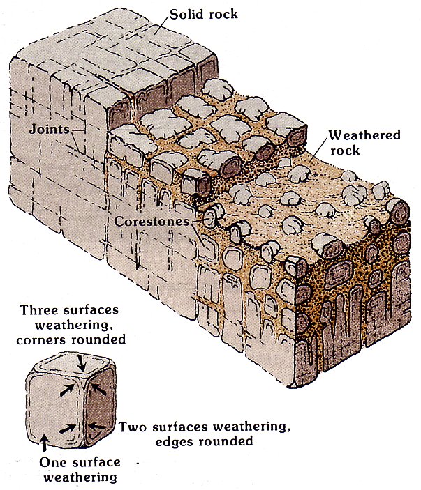
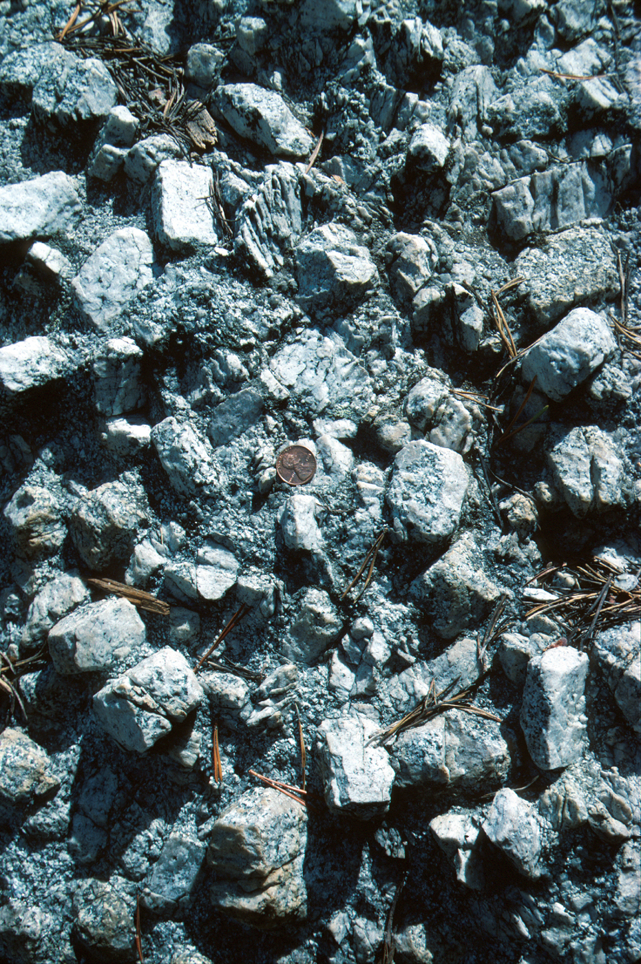
Unfractured granite is impermeable, and because weathering processes depend on the presence of moisture, exposed granite surfaces weather slowly. However, where buried by soil and in contact with a chemically reactive mixture of water, atmospheric gases, and organic decay products, granite weathers much more readily. Joints in the granite that provide avenues for deep circulation of ground water permit weathering to proceed well below the buried bedrock surface. As weathering penetrates the rock from joint surfaces, the edges and corners of the joint blocks are affected more rapidly than the sides, because they are attacked from two or three directions at once (fig. 43). The unweathered remnant of granite in the center of the joint block becomes a rounded boulder, called a corestone, and the process of its formation is a form of exfoliation called spheroidal weathering (fig. 44).
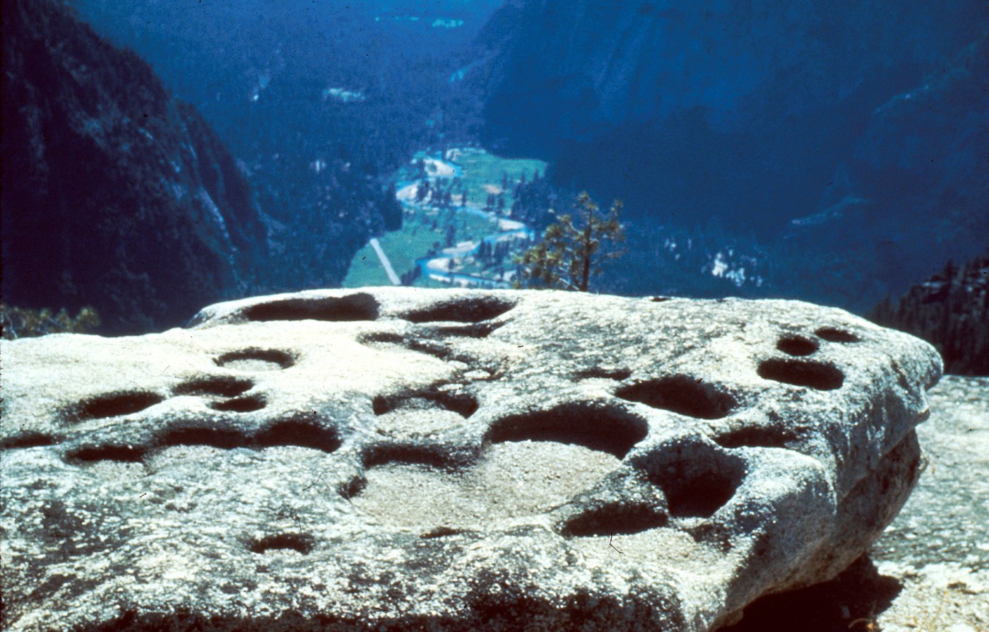
Where water collects in small natural depressions on granitic-rock surfaces, the weathering process commonly enlarges the depressions to form weather pits, or pans (fig. 45). The pans are typically flat bottomed, a fact that has not yet been completely explained. A possible explanation is based on the proposition that the most active environment for weathering is the zone of alternate wetting and drying along the margins of the pools that collect in the pans. The margins tend to deepen and enlarge until all points of the bottom of the pan are equally wet or dry at the same time. Thereafter, they weather downward at a rate that is constant over all of the pan surface. This explanation also accounts for the overhanging rims, which are very common, and for coalescing pans, which also are common. The flat floors of the pans are horizontal even where the pans occur on the sides of boulders. The weathered material in the pans is removed by wind, although in deeper ones a granite sand remains. The process is a slow one—such pans normally are not found on surfaces scraped smooth during the last major glaciation, which ended some 10,000 years ago.
| WEATHER PANS formed on summit of North Dome, high above Yosemite Valley. Neighboring pans coalesce as a result of progressive expansion at the expense of intermediate partitions. Photograph from National Park Service collection. (Fig. 45) |
[click to enlarge] |
[click to enlarge] |
|
RESISTANT POTASSIUM FELDSPAR PHENOCRYSTS
protrude from weathered surface of Cathedral Peak Granodiorite. Matrix minerals formerly enclosing the phenocrysts have been weathered to grus (granite sand) and washed away. (Fig. 46) |
The weathering and disintegration of rock, making it susceptible to erosion, depend on both rock composition and rock texture. The darker varieties of medium-grained granitic rocks, particularly those rich in biotite, weather more readily than the lighter colored varieties. Expansion of the biotite by absorption of water helps free the crystal from surrounding mineral grains and thus leads to disaggregation of the rock. The resulting granular product, a granitic sand called grus, is easily eroded (fig. 46). For this reason, many topographic basins in granitic terrane are in areas underlain by biotite granodiorite, and ridges are held up by granites that contain less biotite. Finer grained plutonic rocks (both light and dark colored) are generally more resistant to formation of grus than coarser grained ones. Because the fine-grained rocks occur mostly as dikes and other small bodies, they have less effect on major landforms, although they sometimes create rather spectacular features (figs. 47, 48).
The composition and texture of metamorphic rocks also affect their weathering and erosion. Again, the presence of mica facilitates breakup of the rock during weathering. The most resistant metamorphic rocks are those containing abundant quartz, such as metamorphosed sandstone, and those made dense and hard from baking by magma. Many metamorphic rocks are more resistant than plutonic rocks; metamorphic rocks hold up much of the Sierran crest along the east edge of the park, as well as the Ritter Range southeast of the park.
[click to enlarge] |
KNOBS of resistant fine-grained diorite protrude from weathered outcrop surface of El Capitan Granite. (Fig. 47) |
|
NATURAL BRIDGE formed where weather-resistant
aplite bridges an opening eroded in underlying, less resistant Half Dome Granodiorite. (Fig. 48) |
[click to enlarge] |
AGENTS OF EROSION
Erosion, simply stated, is the removal of earth materials from high areas to low areas. Erosion thus tends to level a high area.
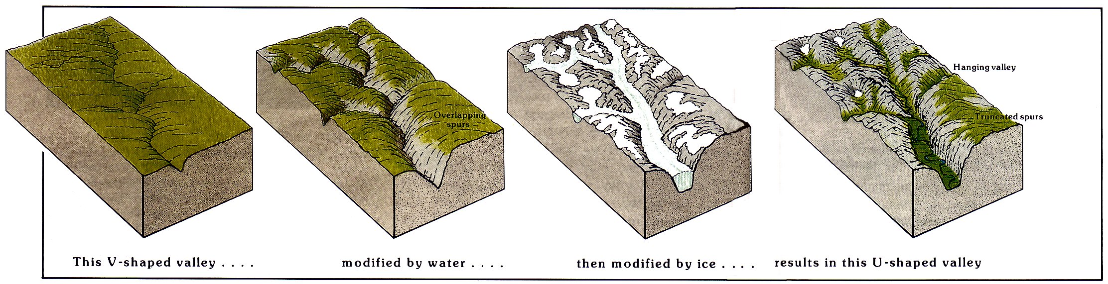
Two agents of erosion are chiefly responsible for sculpting the present Yosemite landscape—flowing water and glacial ice. Flowing water had the major role, and glaciers added the final touches. The major drainages, the intervening divides, and the general landforms were all established before glaciation. Some of the glacial modifications were profound: the creation of alpine topography full of cirques and arêtes along the higher divides, the rounding of many valleys from V-shaped to U-shaped and their straightening in the process, and the creation of hundreds of lakes and ponds where formerly there were none.
Still another agent of erosion is simply gravity. The downslope movement of rock materials without the aid of a transport medium produces landslides and rockfalls. Although generally of local extent, such movement is important, particularly in mountainous terrain. In the winter of 1982, a rockfall dropped huge blocks of granite on Route 140 near the junction of the Old Coulterville Road, about 2 mi east of the Arch Rock Entrance Station (fig. 49). The highway remained closed until a way could be blasted through the debris, and the little-used Old Coulterville Road on the slope above was blocked severely enough to be abandoned.
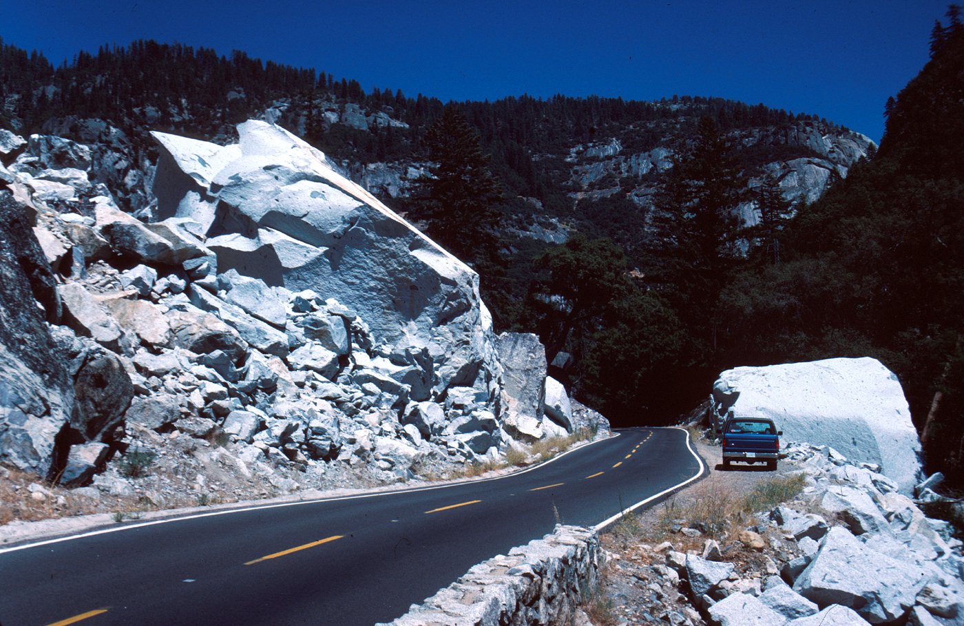
[click to enlarge] |
|
ROCKFALL of blocks the size of small houses temporarily
closed the El Portal Road east of Arch Rock Entrance Station in 1982 until a way could be blasted through the debris. [Editor’s note: This boulder was demolished by road crews after the 1997 flood—dea.] (Fig. 49) |
THE ROLE OF FLOWING WATER
The work of flowing water can be seen at all scales, from that of tiny rivulets cascading down a slope after a rain and transporting soil-size particles, to raging flood torrents with streams using stones as hammers to break up material in their beds. But flowing water can transport cobbles and boulders only during the high-energy, turbulent flow of floods. Thus, the effectiveness of erosion by flowing water depends largely on processes of weathering, the breakdown of parent rock into molecules and rock or mineral fragments that the streams can transport easily.
With the onset of late Cenozoic uplift of the range, the major streams were rejuvenated and made more vigorous by their increased gradients. In a mountain range that is rising faster than upland material can be removed, the tendency is for major streams to cut deep canyons, with both the local topographic relief and the maximum elevation of the range increasing. This canyon cutting requires that river-channel incision be faster than hillslope erosion. If river-channel incision can keep up with uplift but hillside erosion cannot, then stream channels become progressively deepened relative to areas between streams. In particular, for rocks resistant to weathering, channel incision will be relatively much faster than hillslope erosion, and a canyon is formed. Yosemite has superb examples in the canyons of the Tuolumne River, the Merced River (fig. 50), and the South Fork of the Merced River. The upper basins of these rivers were later modified by glacial erosion, but the fact that the rivers flow in deep canyons beyond the western reach of past glaciers shows that canyon rutting was accomplished solely by the action of streams.
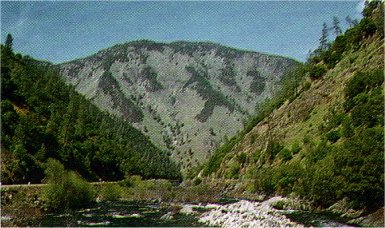
[click to enlarge] |
|
DEEPLY INCISED, UNGLACIATED CANYON of the
Merced River about 7 mi west of El Portal. Photograph by Dallas L. Peck. (Fig. 50) |
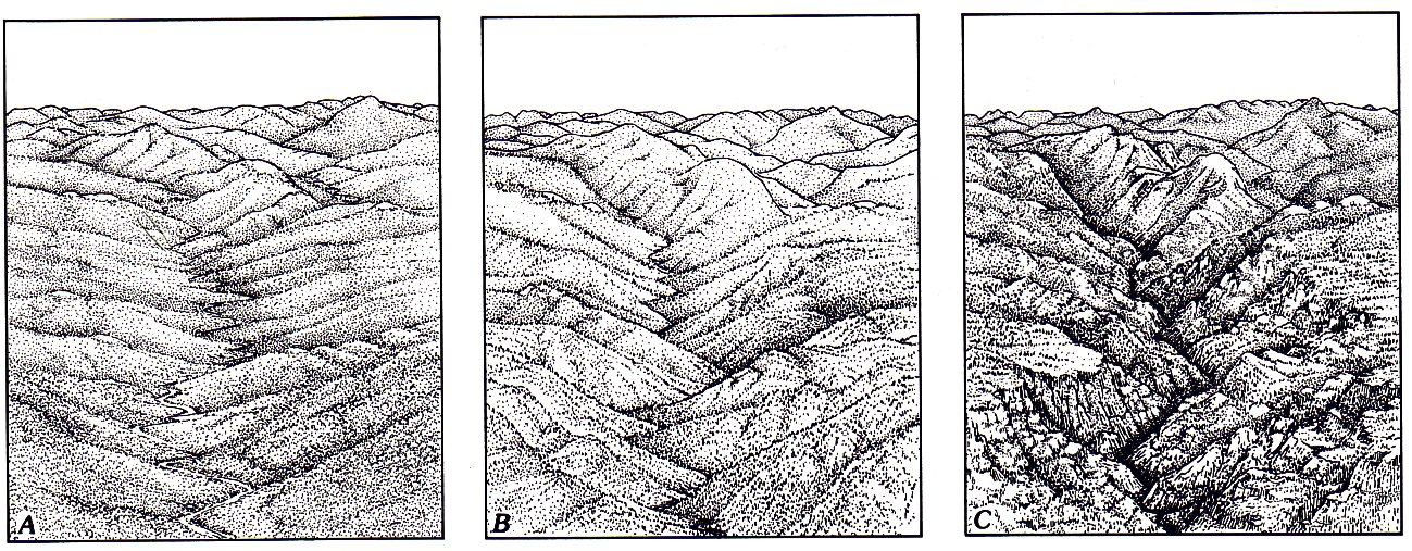
The general courses of the major streams in Yosemite, with few exceptions, were probably inherited from the preuplift drainage pattern and depend mainly an the westerly slope of the range. The courses of the tributaries to the trunk streams and the shapes of their drainage basins depend more on granite composition and joints, as discussed in previous sections. The results of stream incision are depicted in a series of sketches that interpret landscape development from a region of gently rolling hills with meandering streams to one of canyonlands cut into the upland surface (fig. 51). These scenes should be viewed as snapshots in a continuing process, rather than as distinct stages in landscape evolution. Note that granite domes form as the relief increases. The final scene is one conception of what Yosemite looked like about 2 or 3 million years ago, before the onset of glaciation.
[click to enlarge] |
THE ROLE OF GLACIERS
The Yosemite landscape as we see it today strongly reflects the dynamic influence of moving ice that long ago covered much of it several times. We are still uncertain as to how many times ice mantled Yosemite, but at least three major glaciations have been well documented in the Sierra Nevada, and other evidence suggests additional glacial episodes.
Formation of glaciers requires that some of the snow that falls each winter persist through the following summer into the next winter’s accumulation season. Thus, heavy winter snowfall or cool summer temperatures, or both, favor the growth of glaciers. If these conditions persist for a few centuries, possibly less, the layers of accumulating snow form a deposit thick enough for the snow in the lower part of the deposit to be compacted into ice (fig. 52). At a thickness of about 100 ft, ice begins to flow outward under its own weight, and on slopes will begin to flow downhill at lesser thicknesses; when it flows, a glacier is born.

[click to enlarge] |
MACLURE GLACIER, showing annual layers of ice accumulation exposed after melting of seasonal snow. Note people for scale in lower right. The layers slant upward into the glacier; the youngest layers are highest up the slope. Photograph from National Park Service collection. (Fig. 52) |
As the glacier flows downhill, it enters regions of warmer climate, where the snow does not persist from year to year. The boundary where loss from melting and evaporation equals accumulation from snowfall is called the annual snowline or firn limit— “firn” being the term for partially compacted snow carried over from previous seasons (fig. 53). The firn limit fluctuates from year to year in response to changes in precipitation and temperature. The firn limit can be as much as 1,000 ft lower in elevation on the shaded north sides of mountain peaks than on their sunny south sides. For this reason, nearly all of the small present-day glaciers in the Sierra are on north-facing slopes.
| VALLEY GLACIER sectioned to show relation between accumulation and wastage areas. Annual snowline, or fern limit, is the boundary where accumulation from seasonal snowfall equals loss from melting and evaporation. (Fig. 53) |
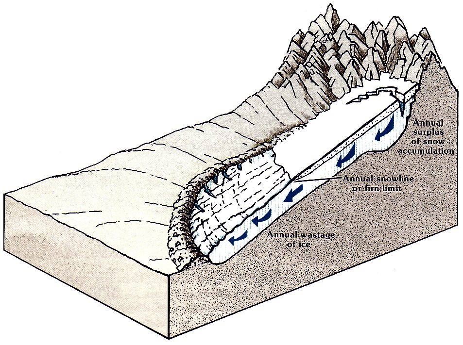
[click to enlarge] |
The section of the glacier through which the maximum amount of ice flows coincides with the firn limit, because as the glacier flows toward the firn limit, it is continually augmented by new net snowfall; and downvalley from the fim limit, more ice is lost by melting and evaporation—together called ablation—each year than is added by snowfall. As the glacier flows downvalley from the firn limit, more and more of the ice ablates, and the glacier grows thinner or narrower, or both. Ultimately a point is reached where the ice front can advance no farther because the ice melts there as rapidly as it is provided by inflow from upglacier. If the yearly rates of accumulation and ablation were constant, this point would be fixed. However, they vary, and for that reason alone the terminus of the glacier is not likely to be fixed in position. As the climate turns warmer or drier, a glacier will gradually waste away, rather than melting catastrophically.
Glacial erosion
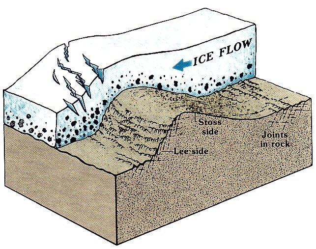
[click to enlarge] |
|
ROCHE MOUTONNÉE, sectioned to show the influence of
jointing on its development. The ice moves upward over unjointed rock, smoothing it off, and plucks up and carries away blocks of jointed rock. (Fig. 54) |
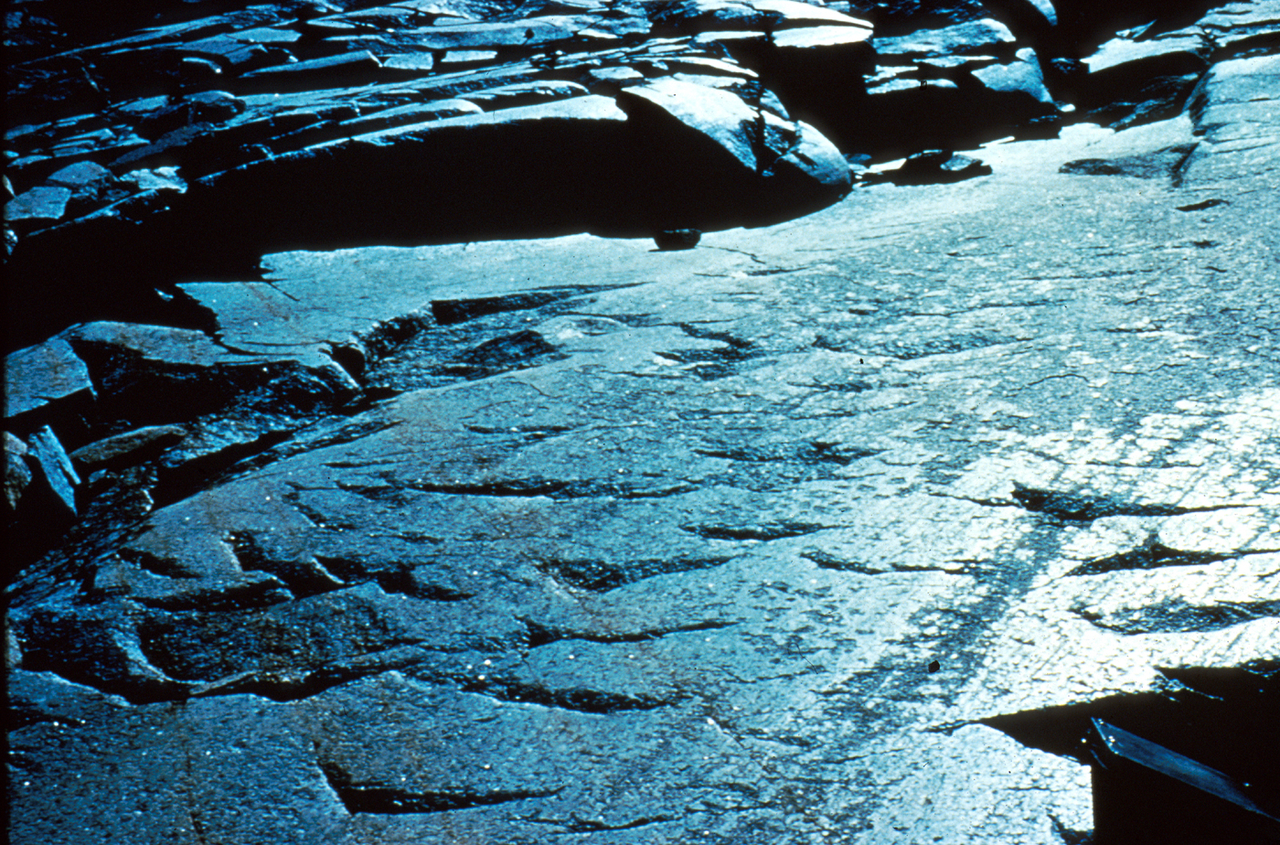
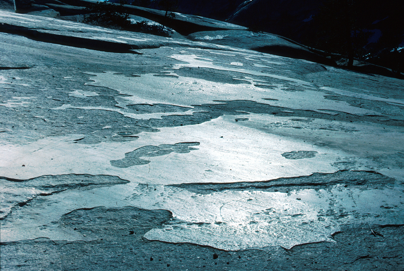
The velocity at which a glacier slips over its bed is only about half the ice velocity measured at its surface; the difference is taken up by deformation within the moving ice. But it is the slippage over the bed that is responsible for glacial erosion. Wherever basal flow is especially strong, or the rock easily removed, bedrock basins are carved, which eventually hold lakes. The glaciers widen and deepen valley bottoms to give a characteristic U-shaped profile. On the leesides of bedrock projections into the ice are regions of low pressure where meltwater refreezes in cracks in the rock, prying loose blocks of bedrock that are then incorporated into the glacial ice and quarried away. Asymmetric rock knobs with smoothly abraded stoss, or upstream, sides and jagged and quarried leesides are called roches moutonnées and record the direction of glacier flow (fig. 54). Commonly translated as “sheep,” moutonnée is actually a French adjective meaning “fleecy”; the term was introduced into geology in 1786 to describe rounded Alpine hills whose repeated curves, taken as a whole and as seen from a distance, resemble a thick fleece. As rock fragments embedded in the basal ice are dragged across the bedrock surface, they impart scratches, grooves, crescentic gouges, and a shining polish (fig. 55).
[click to enlarge] A |
[click to enlarge] B |
| IMPRINTS ON THE ROCK left by passing debris-laden ice. A, Glacial polish and striations (lower right). Crescentic gouges, or percussion marks, are visible in center; horns of the crescents point upglacier. Chatter marks (not illustrated) consist of a group of crescent-shaped cracks pointing downglacier, but generally they do not form gouges. Photograph by John P. Lockwood. B, Glacial polish and striations. Polished surface layer flakes off, and this evidence of glaciation gradually disappears. This excellent and accessible exposure is at the foot of Polly Dome along the Tioga Road on the north side of Tenaya Lake. (Fig. 55) | |
Another feature of glacial erosion is the bowl-shaped,
theaterlike valley head called a cirque
(fig.
56).
During the summer season, when no new snow
is accumulating and the ice pulls away from the rock
face at the head of the glacier, a great crevice, called
a bergschrund, opens. This opening exposes the rock
at the head of the cirque to freezing and thawing,

[click to enlarge] |
|
MOUNTAIN CREST, showing valley glacier and glacial
sculpture. (Fig. 56) |
The cliffs behind the cirques and above the glacier surface elsewhere are also sculpted by the freezing of water in cracks in the rock. Expansion of water when it freezes to ice breaks and wedges out blocks, which then avalanche onto the glacier’s surface below. The falling blocks knock loose any projecting rock in their paths, and chip away fragments as they bounce down the cliff face. The hollows created by the detachment of these blocks and by the erosion they cause on their fall collect and hold more moisture than do the projecting ribs between them; they thus retreat more rapidly by frost wedging than do the ribs, so that even if initially smooth, a cliff face, given enough time, can become intricately sculptured.
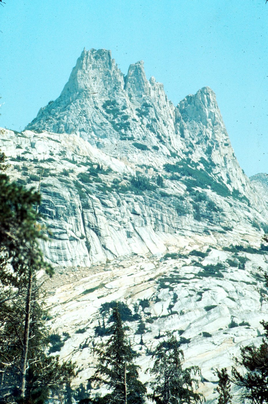
As the cliffs on opposite sides of a ridge are quarried back by frost action above the active cirque glaciers, they eventually intersect to form a sharp, jagged rock crest called an arête, with sharp peaks, called horns, where the ridges branch (fig. 56). The sharp change in character of the walls of glaciated valleys—from intricate and jagged sculpturing above, to smooth sculpturing below—marks the edge, or trimline, of the former glacier and makes it possible to reconstruct the former margin of the mountain icefield (fig. 57).
|
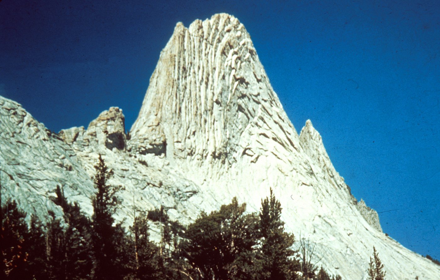
JAGGED UNGLACIATED SPIRES of Unicorn Peak rising
above smooth shoulders of glacially scoured granite. Boundary between jagged sculpture above and smooth below, called the trimline, marks upper limit of a former glacier along the valley wall. (Fig. 57) |
[click to enlarge] |
Glaciated valleys are nearly straight and have U-shaped crossprofiles, in contrast to the sinuous V-shaped valleys of normal stream erosion (figs. 50, 58). At the high velocities of running water, inertia throws the fastest current against the outside of a bend. At the much slower velocities of glacial ice, the fastest flow is on the insides of bends, where the distance is shorter and the ice surface is steepest. Thus, whereas a stream erodes the outsides of bends preferentially and makes its course more sinuous, glacial erosion is concentrated on the insides of bends, removing the overlapping spurs of the original stream-eroded valley and leaving a wide, straight valley floor in place of the sinuous one. A major factor leading to the U-shaped crossprofile of glacial valleys is the ability of a glacier to erode far up the valley walls. The entire glaciated valley was once occupied by the former glacier that carved it, whereas a stream occupies only the very bottom of its valley.
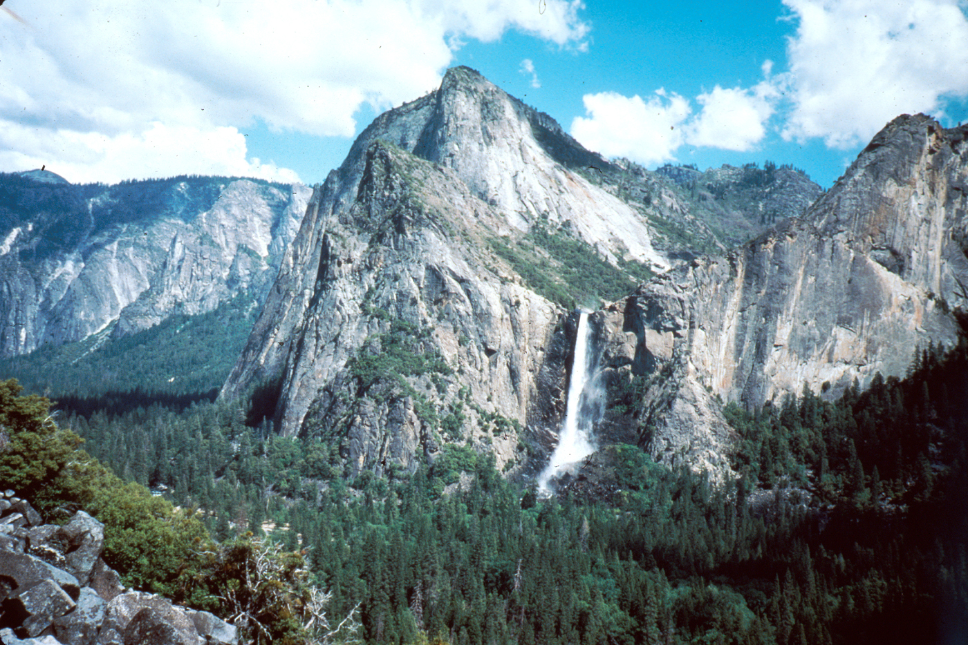
In addition to truncated spurs, hanging tributary valleys are formed on the sides of glaciated valleys. In a landscape developed by stream erosion, tributary streams normally join the main-think river at the same level. During glaciation, the upper surfaces of the glaciers occupying the tributary valleys join at the level of the surface of the ice filling the main channel; but beneath the ice the trunk glacier, with its greater thickness and erosive power, carves much more deeply into the bedrock than the tributary glaciers can. When the glacier wastes away and the ice is all gone, the tributary valleys are left hanging high up on the sides of the trunk valley, and their streams cascade or fall to join the main river below (fig. 58). During the time since the pre-Tahoe glaciation, when Yosemite Valley acquired nearly its present form, spray from the waterfalls freezing in cracks ib the rock at the base of the cliff promoted spalling of rock slabs there and formed the recessed alcoves into which the falls now leap. Most of the waterfalls in Yosemite Valley formed in this manner and, indeed, are the finest examples anywhere (fig. 59). Thus, throughout the world the name “Yosemite” has come to spell “waterfalls.”
| VALLEY MODIFICATION by glacial erosion, showing stages in the conversion of a meandering V-shaped valley into a straightened U-shaped valley. (Fig. 58) |
[click to enlarge] |
[click to enlarge] |
|
BRIDALVEIL FALL, an outstanding example of a waterfall
issuing from a hanging valley far above Yosemite Valley floor. Photograph by Julia A. Thomas. (Fig. 59) |
Glacial deposition
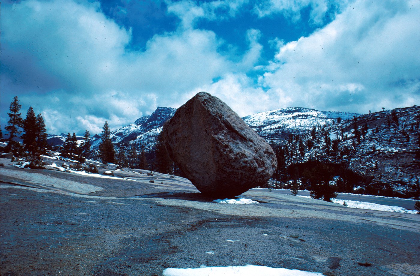
Glacially carved landforms are the most striking evidence of the passage of long-gone ice masses. But glaciers must eventually deposit the materials they are transporting, and in the process they also build up characteristic landforms. The material deposited by glaciers is an unsorted mixture of boulders, sand, and clay called till (fig. 60). Till may be deposited by the glacier on its bed as it is actively flowing, or the till may be left behind as the ice melts away, generally beginning as an accumulation of rock debris on the ice surface. Other depositional evidence of ice includes glacial erratics, boulders left behind as the ice melted (fig. 61). Direction of glacial transport is commonly indicated by boulders of rock types different from the bedrock on which they rest, but that can be traced back upglacier to a source area. Whereas till is the unsorted material deposited by a glacier, the deposit itself is known as moraine, and such moraine takes different topographic forms, depending on how the till was deposited.

[click to enlarge] |
|
GLACIAL TILL, an unsorted mixture of boulders, sand, and
clay, exposed along the Tioga Road at Siesta Lake. (Fig. 60) |
[click to enlarge] |
|
GLACIAL ERRATIC transported by a glacier and left
precariously balanced near Olmsted Point as the ice melted. (Fig. 61) |
The most distinctive morainal features in the Sierra Nevada are lateral moraines, linear ridges of till that rest on the sides of the glaciated valley and extend parallel to the valley axis (fig. 62). These ridges generally define the maximum height and width of the glacier that deposited them. Commonly, lateral moraines curve around at their lower ends to form terminal moraines, ridges of till deposited at the terminus of a glacier. When a glacial cycle ends, glaciers do not always melt back uniformly; instead, they commonly pause periodically in their retreat, constructing a series of recessional moraines. Excellent examples of all these varieties of moraines can be seen in Lee Vining Canyon just east of the park (fig. 63).
Most of the terminal and recessional moraines on the west side of the Sierra Nevada have been breached or removed by swift meltwater streams, and it is doubtful whether they were even deposited in the steep narrow canyons of most of the west-flowing streams, such as the Merced River west of Yosemite Valley. The glaciers that debouched onto the lowlands along the east base of the Sierra Nevada, however, left distinct terminal moraines, some of which presently enclose lakes.
Where two glaciers join to form a single trunk glacier, the lateral moraines being formed on their adjoining sides will continue as a linear train of debris outward onto the surface of the trunk glacier. This train is called a medial moraine, and when the glacier melts, the debris will form a linear ridge parallel to the axis of the glacial valley. Such a medial moraine can be seen where the Merced and Tenaya Glaciers once joined at the east end of Yosemite Valley.
The total amount of till left as moraine in Yosemite and elsewhere on the west slope of the Sierra Nevada is small, however, in comparison with the amount of glacially derived debris that was flushed out of the mountains by streams swollen with glacial meltwater. Most of that debris was then deposited as alluvial fans and valley fill in the Central Valley, and some of the finer material traveled even farther, finally coming to rest in the San Francisco Bay and the Pacific Ocean.
| MORAINES formed by a valley glacier. Lateral moraine formed along side margin of glacier; terminal moraine formed at point of farthest glacial advance; and recessional moraine formed during pause in retreat of glacier. Ground moraine is a rather shapeless, hummocky till deposited beneath a glacier or simply left behind as the glacier retreats or wastes away. (Fig. 62) |

[click to enlarge] |
[click to enlarge] |
|
MORAINES IN LEE VINING CANYON east of Tioga
Pass, looking westward toward crest of the Sierra. Paired lateral moraines on both sides of the canyon extend toward the viewer; the outer pair (O) represent the Tahoe glaciation, and the inner pair (I) the Tioga glaciation. The inner pair of moraines coalesce to form a terminal moraine (T) at lower left. A recessional moraine (R) crosses the valley as a low, tree-lined ridge. Photograph by Clyde Wahrhaftig. (Fig. 63) |
The record of glaciation in Yosemite National Park is very incomplete. Only for the last two major glaciations can the extent of the ice be reconstructed with any confidence. Older glacial deposits, if preserved at all, are so fragmentary that it is generally impossible to distinguish the separate ice advances that may have deposited them. The glaciers grew and melted away in response to climatic changes of long duration that were probably worldwide, and so a record of all the glaciations that might have affected Yosemite must be sought elsewhere.
During worldwide glacial cycles, large volumes of water evaporated from the oceans arc stored on land as ice; this storage causes a decrease in the volume of water remaining in the oceans. During evaporation of seawater, the light isotope of oxygen—oxygen-16—is more easily lost to atmospheric vapor than is the heavy isotope-oxygen-18. When this vapor precipitates on land and is stored as ice, rather than returning to the oceans, the ratio of these two isotopes of oxygen remaining in the ocean will change. Organisms living in the oceans at any given time secrete calcareous shells whose ratio of oxygen isotopes is comparable to that of the water in which the organisms lived. Measurements of fluctuations in this ratio provide indirect measurements of ice volume, with times of large ice volume interpreted as glacial episodes. Isotopic measurements on such shells extracted from deep-sea sediment samples indicate about 10 major glacial episodes during the past 1 million years. Normally, evidence for only a small fraction of these glaciations can be found in a given area on land, because the more extensive glaciers destroy the moraines of earlier, less extensive ones. Only if older glaciers extended beyond the limits of younger glaciers will the older deposits remain to document the earlier glacier’s existence, and so the glaciations now recognized in Yosemite may be only a fraction of those that actually occurred.
François Matthes presented evidence for three major
glaciations in Yosemite, which he called, from youngest
to oldest, Wisconsin, El Portal, and Glacier Point.
Working on the east side of the Sierra about the same
time, Eliot Blackwelder recognized four major glaciations:
Tioga, Tahoe, Sherwin, and McGee; these latter
terms have become firmly established and have largely
replaced those of Matthes. His Wisconsin is now
thought to include equivalents of both the Tioga and
Tahoe glaciations, and his El Portal is probably equivalent
[click to enlarge] |
|
TIOGA MORAINE in Harden Lake area, showing sharp
crest and abundant boulders exposed on surface. (Fig. 64) |
[click to enlarge] |
|
TAHOE MORAINE in Harden Lake area, showing subdued
crest and only scattered boulders exposed on surface. (Fig. 65) |
[click to enlarge] |
|
PERCHED ERRATIC deposited on ridge west of Upper
Yosemite Fall during a pre-Tahoe glaciation. Pedestal height of 5 ft indicates amount of rock weathered away since boulder was dropped by the ice. Photograph from National Park Service collection. (Fig. 66) |
In Yosemite, deposits of three separate glacial episodes are now distinguished on the following basis:
1. Tioga (youngest): Unweathered till consisting of fresh granitic boulders and loose, porous gravel and sand, making sharp-crested moraines that have closely spaced boulders on their upper surfaces (fig. 64).
2. Tahoe (intermediate): Subdued moraines whose buried granodiorite boulders have commonly disintegrated at least partly to gnus. The summits of these moraines tend to be rounded, and exposed boulders along their crests are generally sparse (fig. 65).
3. Pre-Tahoe (oldest): Outside the ice limits defined by the intermediate moraines, a few glacial erratics, commonly perched (fig. 66), and patches of formless glacial till give evidence of at least one earlier ice advance more extensive than the glaciers that deposited the intermediate moraines.
By recognizing these distinctions, we can at least partly reconstruct the glacial geology of Yosemite.
The glacially related features of today’s landscape, both erosional and depositional, largely reflect the latest major glaciation, the Tioga. The effects of multiple glaciations are cumulative, however, and the effects of earlier glaciations must have been substantial, although we can only gauge them by inference. We shall examine the end results of these episodic glaciations culminating with the Tioga, and then examine the evidence for the work of earlier glaciations.
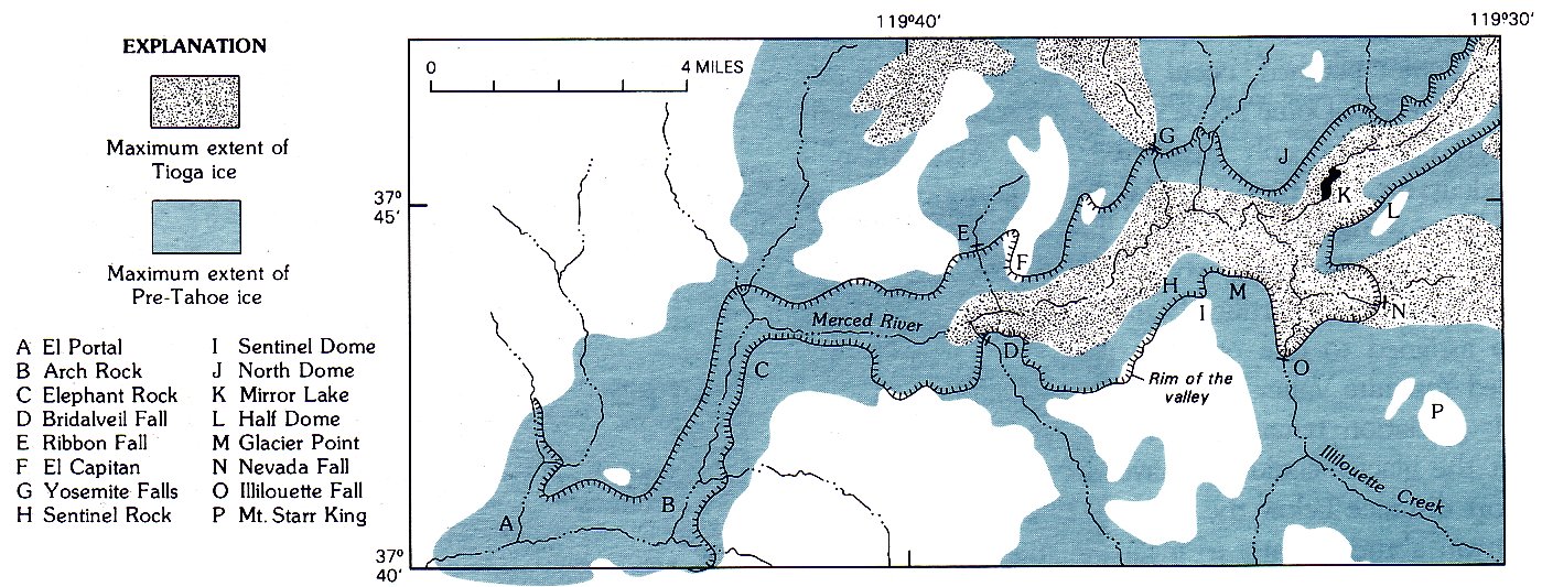
The Tioga glaciation began about 30,000 to 60,000 years ago, when a cooling climate permitted small glaciers to develop in high cirques originally formed and then abandoned by earlier glaciers. With continued cooling, these glaciers grew and moved outward and downward to coalesce into a mountain icefield, with only the higher peaks and divides projecting through as arêtes and horns. With further growth, the icefield fed fingers of ice into the major drainages on the west slope of the Sierra, until the ice reached its maximum extent about 15,000 to 20,000 years ago (fig. 67).
The icefield in the upper Tuolumne River basin, and in the tributary basins to the north, fed the glacier that moved down the canyon of the Tuolumne River through Hetch Hetchy Valley. Some of the ice filling the basin of the Lyell Fork of the Tuolumne spilled over low passes to augment ice in the Merced River basin that flowed down through Little Yosemite Valley. Tuolumne ice also flowed over a pass into the Tenaya Lake basin and down Tenaya Canyon to join the main Merced Glacier in Yosemite Valley. During the Tioga glaciation, the glacier in Yosemite Valley reached only as far as Bridalveil Meadow.
| TIOGA ICEFIELD AND VALLEY GLACIERS, showing maximum extent during the Tioga glaciation, the last major glaciation in the Sierra Nevada, which peaked about 20,000 to 15,000 years ago. (Fig. 67) |
[click to enlarge] |
Tioga ice also flowed eastward from the summit region to cascade down canyons cut into the east escarpment of the Sierra. Southeast of the park, ice from the Mount Lyell area flowed eastward onto the Mono lowland and southeastward and southward down the Middle and North Forks of the San Joaquin River. In the southern part of the park, ice in the South Fork of the Merced River reached nearly to the present site of Wawona.
In addition to the major icefields in the headwaters of the Tuolumne and Merced Rivers and the major valley glaciers they fed, smaller, isolated glaciers formed in favorable localities, as on Buena Vista Crest, Horse Ridge, and above Siesta Lake near the Tioga Road. Each played a part in creating today’s landscape.
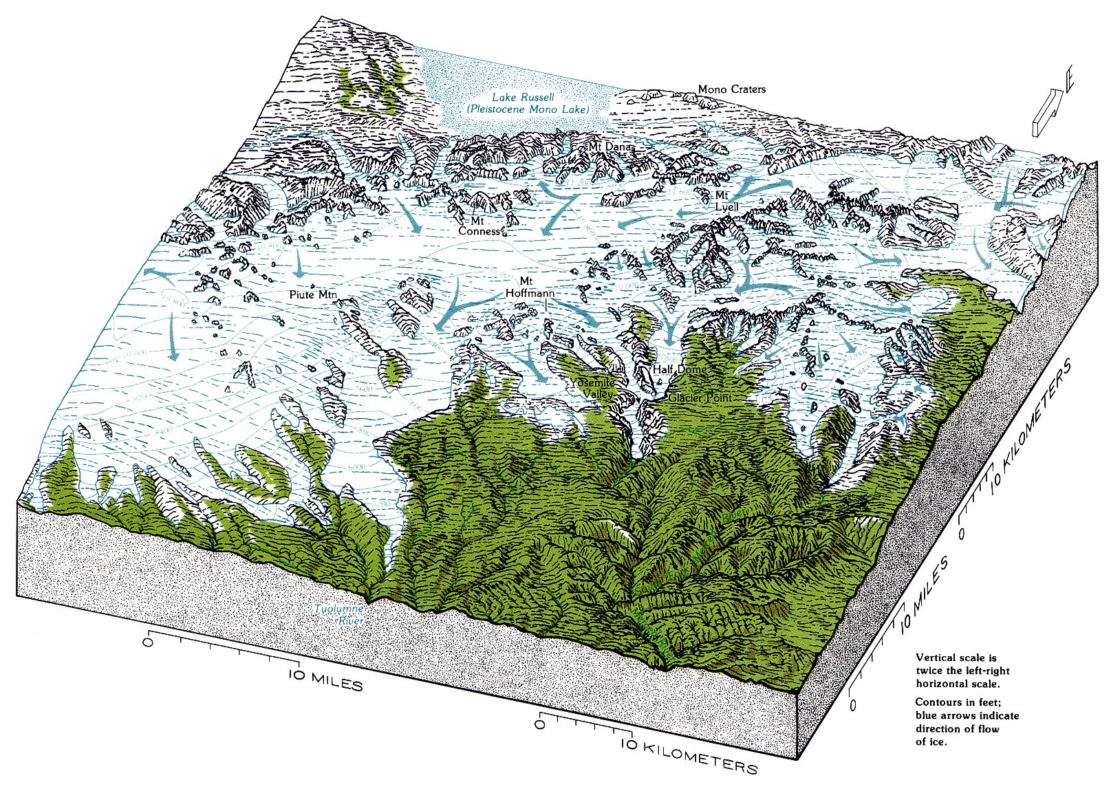
At the time of the Tioga glacial maximum, glacial Lake Russell was much larger than the present-day Mono Lake (fig. 67). The surface elevation of Lake Russell at that time was about 6,800 ft, 425 ft higher than the 1980 elevation of Mono Lake of about 6,375 ft. The increased volume of Lake Russell was probably due to a much lower rate of evaporation of water from the lake during Tioga time, partly because of the prevailing cooler climate and partly because the lake probably was covered by ice much of the time.
|
| U-SHAPED GLACIATED VALLEY, the Lyell Fork of the Tuolumne River, looking southward. Photograph by Robert W. Cameron. © Cameron and Company; used with permission. (Fig. 68) |
The Tuolumne Meadows area is one of the most accessible, as well as one of the best, places to see how glaciers modified the landscape by both erosion and deposition. The Lyell Fork of the Tuolumne River flows to the meadows through one of the park’s finest examples of a U-shaped valley (fig. 68). The frost-riven spires of Unicorn and Cathedral Peaks standing above smoothly rounded granite shoulders graphically indicate the height to which Tioga ice reached (fig. 57). Glacial polish high on Fairview Dome indicates that it was overtopped by ice (fig. 69). Lembert Dome, on the northeast side of the meadows, is a roche moutonnée that records stoss-side smoothing and leeside plucking on a grand scale, as does the smaller but easily ascended Pothole Dome at the meadow’s west end (fig. 70). Glacial polish and striations can be seen on many outcrops, and erratic boulders abound.
[click to enlarge] |
|
GLACIAL POLISH high on east shoulder of Fairview Dome.
It and similar polish and erratics on the summit indicate that the dome was once overtopped by ice. (Fig. 69) |
A series of potholes angles diagonally from level ground up the south side of Pothole Dome (fig. 71). The rock polish near these potholes can easily be mistaken for glacial polish, but it has a different origin. Unlike glacially polished surfaces, which are generally planar, these surfaces are fluted (fig. 72), like those forming on bedrock today by flowing water of the Tuolumne River. Both the polish on this part of Pothole Dome, and the potholes themselves, were created by water in a subglacial stream that flowed upward over the dome in a tunnel beneath ice of the Tioga glacier. Glacial polish can, indeed, be seen on the gentle east-facing slope of the dome, the stoss side of this roche moutonnée.
| POTHOLE DOME, a large roche moutonnée on the west side of Tuolumne Meadows, was shaped by glacial smoothing and plucking. Ice moved from right (stoss side) to left (beside). Fluted surface was shaped by subglacial water scour (see fig. 72). (Fig. 70) |
[click to enlarge] |
|
POTHOLES angling up side of Pothole Dome, west side of Tuolumne Meadows. Bowl-shaped potholes are carved into the rock by the grinding action of stones whirled around and kept in motion by the force of a stream in a given spot. Here, the stream flowed in a tunnel beneath the ice that covered this area during the Tioga glaciation. (Fig. 71) 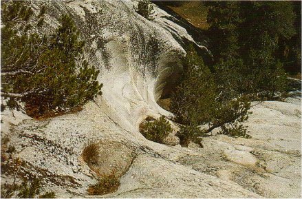
[click to enlarge] |
[click to enlarge] SUBGLACIAL WATER POLISH on Pothole Dome, formed by water flowing beneath the glacier. Surface is fluted rather than flat, as with glacial polish (compare with fig. 55). Polished surface layer is flaking off, similar to the glacial polish shown in figure 55B. (Fig. 72) |
[click to enlarge] |
KETTLES (small lakes) near Tioga Pass, filling depressions left by the final melting of blocks of glacial ice. View eastward across Dana Meadows toward Mount Dana. (Fig. 73) |
Most of the till in the Tuolumne Meadows area was deposited as hummocky ground moraine beneath the glacier, or left behind as the glacier wasted away. The small lakes in ground moraine southeast of the entrance station at Tioga Pass appear to be kettles, depressions left by the final melting of blocks of ice buried in till (fig. 73). Elongate ridges of moraine flank the roadway between Tioga Pass and Tuolumne Meadows, and a cross section through such till is exposed in a roadcut about 11 mi east of the Tuolumne River bridge. Lateral and recessional moraines are inconspicuous and may be absent in the Tuolumne Meadows area, but magnificent examples of both are in lower Lee Vining Canyon along the Tioga Road east of the park (fig. 63).
Yosemite Valley, in spite of its profound glacial modification, is not a good place to see much direct evidence of glaciation. The Tioga glacier only reached as far as Bridalveil Meadow, where its terminal moraine, although well exposed in a roadcut (fig. 74), is relatively inconspicuous, and lateral moraines are absent. Glacial polish and striations are scarce, but they can be seen on a low, flat shelf of rock near the base of the north valley wall opposite the west end of the Yosemite Lodge, and along the base of the cliffs on the north side of the Tenaya Lake Trail, about 500 to 1,000 ft east of Mirror Lake. Glacial polish also occurs in such places as on the slope of the Glacier Point apron, but these localities are accessible only to the experienced climber. This paucity of direct evidence is probably the basis for Josiah Whitney’s stand against the glacial origin of Yosemite Valley, noting as he did the glaciation of Hetch Hetchy Valley, where he described glacial polish at least 800 ft and a glacial moraine 1,200 ft above the valley floor.
The Tahoe glaciation was almost everywhere somewhat more extensive than the Tioga, and so its moraines lie outboard of Tioga moraines. Recent studies suggest that Yosemite Valley was an exception: a Tahoe-age glacier reached Yosemite Valley but was smaller and thinner, and did not extend as far into the valley as Tioga ice did. If both the Tioga and Tahoe glaciers had limited erosive power in Yosemite Valley because they both were relatively thin, then the valley must have attained nearly its present shape during one or more pre-Tahoe glaciations.
|
GLACIAL MORAINES IN YOSEMITE VALLEY.
A, Tioga-age terminal moraine exposed in roadcut just east of Bridalveil Meadow. This moraine contains large boulders of Cathedral Peak Granodiorite, clear evidence of glacial transport from Tuolumne Meadows via Tenaya Canyon or from the upper Merced River basin via Little Yosemite Valley. B, Tioga-age recessional moraine exposed in roadcut below Cathedral Rock. Large boulder in center is of Cathedral Peak Granodiorite. (Fig. 74) |
[click to enlarge] A |
[click to enlarge] B |
Direct evidence for pre-Tahoe glaciation in Yosemite Valley is also elusive. It consists mostly of scattered, commonly perched erratics on upland areas adjacent to the valley (fig. 66). These perched erratics rest on pillars of rock protected from weathering and erosion by the erratic itself. The surrounding area commonly has been lowered several feet or more by erosion since the erratics were left as the ice melted. This amount of erosion, which is not seen in areas overridden and scoured by Tahoe ice, is the main argument for attributing these erratics to a much earlier glaciation. Readily accessible examples of pre-Tahoe erratics, though not perched, occur near the radio-relay tower on Turtleback Dome above the Wawona Road. A small patch of old, deeply weathered till is exposed in a roadcut on the Big Oak Flat Road just east of the bridge crossing Cascade Creek. This till, about 1,000 ft above the valley floor, would hardly be recognized as such without the artificial cut. These erratics and till are assigned to one or more pre-Tahoe glaciers that filled Yosemite Valley (fig. 75). No terminal moraine for this glaciation remains in the Merced River canyon, but the glacier could not have extended more than a short distance below the town of El Portal, where the canyon abruptly starts to meander and has a V shape (fig. 76).
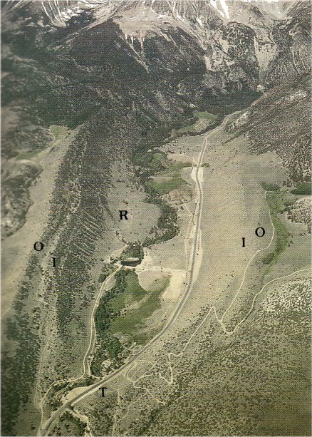
Evidence for three separate glaciations in Yosemite is most readily seen at Harden Lake, about 3 mi down the Old Tioga Road from White Wolf. Harden Lake sits on the edge of the upland bordering the Grand Canyon of the Tuolumne River, which was completely filled with ice during each of the three recognized glaciations. Harden Lake is sandwiched between fresh, bouldery lateral moraines reflecting pulses of Tioga ice (fig. 64). Outside of these moraines, farther from the canyon, are Tahoe moraines, still-linear but subdued ridges, with extensive soil cover and only scattered boulders on the surface (fig. 65). Farthest from the canyon, outside of the Tahoe moraines, are pre-Tahoe erratics and highly dissected till whose original morainal form has been destroyed by erosion.
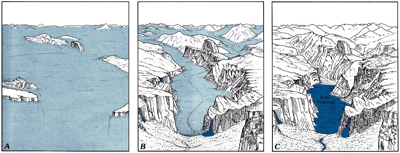
| GLACIERS COME AND GO. Sketches of Yosemite Valley area, showing extent of pre-Tahoe glacier (A), extent of Tioga glacier (B), and glacial Lake Yosemite after retreat of Tioga ice (C). (Fig. 75) |
[click to enlarge] |
[click to enlarge] |
| PRE-TAHOE GLACIATION—its extent in the Yosemite Valley area in comparison with that of the Tioga glaciation. (Fig. 76) |
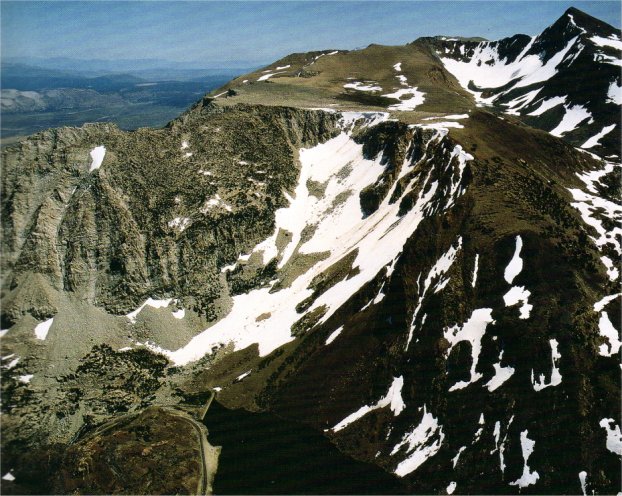
Among the arêtes and cols of the Sierran crest and adjacent spurs are anomalous areas with gently rolling surfaces that escaped glacial sculpting; the Dana Plateau is an outstanding example (fig. 77). These areas apparently never accumulated enough snow to generate glaciers on their upland surfaces. Not only is the Sierran crest swept by strong winds, but it also receives less snowfall than areas farther west because most of the moisture is wrung out of the upwelling stormclouds before they reach the crest. Glaciers did form in cirques on the lower protected slopes of these plateaus, particularly on northerly slopes, where sufficient snow could accumulate by wind drift from the plateaus to the windward and remain through the summer. But these glaciers never succeeded in cutting cirques far enough back into the plateaus to entirely destroy them.
| DANA PLATEAU, unglaciated remnant of an ancient land surface sharply truncated by glacial cirques. Ellery Lake and the Toga Road lie 2,000 ft below. At upper right is Mount Dana, with an unglaciated surface sloping downward to right. These two remnant surfaces are parts of a once-continuous surface breached by a glacial cirque excavated by past glaciers and now containing the present-day Dana Glacier, seen as the gray, oval-shaped spot on the snow below Mount Dana (see fig. 82). Photograph by Robert W. Cameron. © Cameron and Co.; used with permission. (Fig. 77) |
|
[click to enlarge] |
[click to enlarge] |
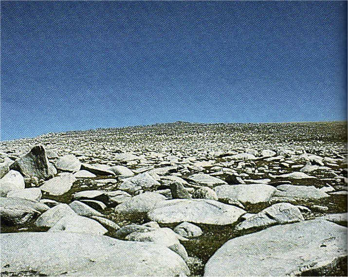
| BOULDER-STREWN UPLAND SURFACE on the Dana Plateau. Frost-heaved joint blocks have been rounded by sand-blasting action of wind-driven grit. Snow chute on Mount Dana near right margin leads down to the Dana Glacier across Glacier Canyon from the plateau. View southeastward. Width of view in middle distance is about 1/2 mi; southeast edge of plateau is about 1 1/2 mi away. (Fig. 78) | |
These upland surfaces did not totally escape the effects of glacial climate. Cycles of freezing and thawing broke the bedrock along fractures and heaved it into a mass of jumbled blocks. Such rubble-covered surfaces are scattered along the Sierran crest, as at Dana Plateau (fig. 78), and include the summit of Mount Whitney 50 mi to the south. The south-facing slope of Mount Hoffmann, our original vantage point in the park, is a somewhat similar upland surface, although slow disintegration and spalling of granite sheets has created an irregular, flaggy surface. This unglaciated surface is abruptly truncated by a glacial cirque cut deeply into the north face of Hoffmann—a striking contrast in erosional processes (fig. 79).
[click to enlarge] |
|
WEST SHOULDER OF MOUNT HOFFMANN.
Smooth, unglaciated south-facing slope (to left) is abruptly truncated by a north-facing glacial cirque—a striking contrast in erosional processes. (Fig. 79) |
These upland surfaces have a significance far beyond being unglaciated, because they are very ancient. They are remnants of the gently rolling terrain that existed here before the late Cenozoic uplift and incision of the Sierra that began about 25 million years ago. As the range was uplifted and tilted, the major westward-flowing streams incised deeper and deeper canyons, cutting headward into the range. The upland areas near the stream headwaters were the last to be affected some remnants still remain undissected.
Although Tioga glaciers were the last to cap large parts of the Sierra Nevada, the modern Sierran glaciers are not remnants of Tioga ice. Instead, they formed during one or more post-Pleistocene cool cycles that François Matthes collectively called the “Little Ice Age.” Because of ambiguity in its definition and wide variation in its application, students of glacial geology have generally abandoned the term, and post-Pleistocene glaciations are referred to as Neoglacial events. The latest of these Neoglacial events in the Sierra Nevada, to which the present-day glaciers belong, has been called the Matthes glaciation in honor of his pioneering studies.
After the end of the Pleistocene (10,000 years ago), temperatures in many parts of the world rose, reaching a maximum about 5,000 years ago. By that time, probably no glaciers survived in the Sierra Nevada. Temperatures then dropped, first slowly, then more rapidly; and small glaciers began to form in the Sierra once again by about 2,500 years ago.
World climate has continued to fluctuate through warming and cooling cycles up to the present. Historical records in the Alps indicate a major glacial advance about A. D. 1600, when glaciers descended into valleys and overwhelmed pastureland and villages. The most recent major advance there occurred about 1850. If Sierran glaciation was synchronous, Yosemite’s modern glaciers would have been near their most recent maximum about the same time that John Muir was making his studies. We do know that Sierran glaciers have been receding rather rapidly since Muir’s day: The first “living glacier” discovered by Muir in 1871, on Merced Peak, no longer exists.
As of 1980, there were nearly 500 glaciers remaining in the Sierra Nevada, most of them so small as to barely show evidence of iceflow, such as a bergschrund. The largest glacier left in the Sierra, the Palisade Glacier in the John Muir Wilderness, covers little more than 1/2 mi2; and the largest in Yosemite, the Lyell Glacier, less than 1/4 mi2 (figs. 80, 81).
| LYELL AND MACLURE GLACIERS. Lyell Glacier (on left) is divided into two parts by an intervening ridge. Lobate terminal moraine below indicates that at the maximum extent of the glacier, the two parts joined at the base of that ridge. Gray areas are ice exposed after melting of seasonal snow. Crevasses are especially well displayed in the ice exposed on the Maclure Glacier (on right). View southward. Photograph by Austin Post, August 1972. (Fig. 80) |
[click to enlarge] |
[click to enlarge] |
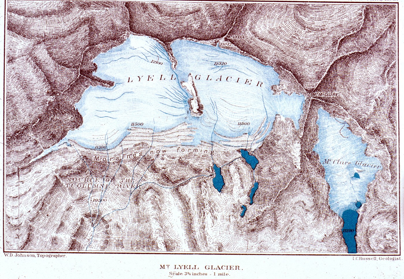
| LYELL AND MACLURE GLACIERS, as they were mapped in 1883 by Willard D. Johnson of the U.S. Geological Survey. Comparison with the present-day glaciers in figure 80 indicates their much greater extent at that earlier date. Mount Maclure, named by Josiah Whitney for an early American geologist, is here mistakenly labeled “McClure.” This error may be the source of occasional confusion in associating the mountain with Lt. N.F. McClure, who, however, was not on the scene as a guardian of Yosemite National Park until after 1890. (Fig. 81) |
[click to enlarge] |
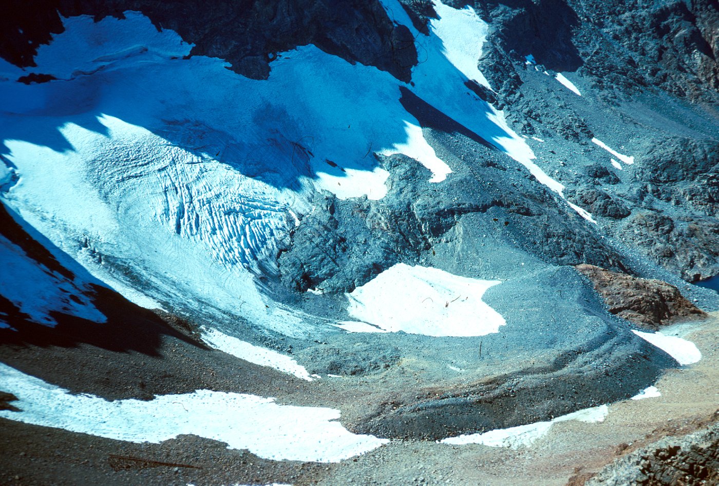
|
DANA GLACIER, 1975. Crevassed ice of the Dana Glacier
is exposed in left center of photograph, and the glacier’s bergschrund is barely visible in shadowed area above. Since the early part of the 20th century, the glacier has retreated headward from its terminal moraine, visible in lower right (compare fig. 83). View southwestward. Photograph by Malcolm M. Clark, September 1975. (Fig. 82) |
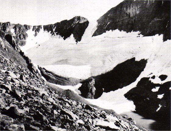
|
DANA GLACIER, 1908. When this photograph was taken
early in the 20th century, ice of the Dana Glacier abutted the terminal moraine, visible in center. Note bergschrund near glacier head below cirque headwall. View southeastward. Photograph by G.K. Gilbert, August 1908. (Fig. 83) |
[click to enlarge] |
Few of the modern glaciers extended very far from their cirques, but many left rather impressive arcuate piles of moraine, considering their small size. Dana Glacier and its moraines are the most readily accessible of those remaining in the park (fig. 82); it is about a 3-hour hike upcanyon from the south shore of Tioga Lake east of Tioga Pass, but does require scrambling over large boulder piles. The glacier is now but a mere shadow of its former self as shown in a photograph taken early in the 20th century (fig. 83). This 1908 photograph shows Dana Glacier nestled up against its terminal moraine, and so it had not receded much, if any, from its latest advance. In the 67 years between the two photographs, the glacier lost about three-fourths of its area and a much larger fraction of its volume.
The cold cycle that brought about the Tioga glaciation ended about 10,000 years ago. Because glaciers during Neoglacial episodes were so small, running water, along with gravity, has dominated further shaping of the Yosemite landscape since Tioga time. The principal changes in landscape have been the filling of lakes with rehandled Tioga till; meadows have formed as a result.
One lake to be converted to meadows was ancient Lake Yosemite, which occupied Yosemite Valley upstream from a moraine dam near the foot of Cathedral Rocks (fig. 75). This was only the last of many “Lake Yosemites” that probably followed each glaciation. The deep excavation created by earlier glaciers, as much as 2,000 ft into bedrock beneath Yosemite Valley, was already filled with glacial till and sediment long before Tioga time, and the Tioga ice had insufficient erosive power to reexcavate the valley to any appreciable depth. Lake Yosemite eventually filled in with silt, leaving today’s level valley floor.
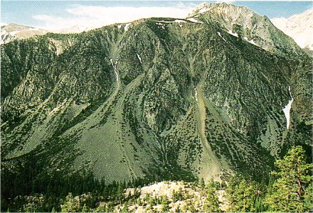
Gravity, commonly aided by water and ice, acting on slopes oversteepened by glacial undercutting, modifies the landscape most visibly. Canyon walls are constantly shedding rock fragments, and tremendous cones of debris accumulate in winter below avalanche chutes (fig. 84).
Rockfalls, the largest probably triggered by earthquakes, can catastrophically move large volumes of material (fig. 85). One rockfall, graphically described by John Muir, occurred in Yosemite Valley during the great Owens Valley earthquake of 1872: “The Eagle Rock on the south wall, about a half mile up the Valley, gave way and I saw it falling in thousands of the great boulders I had so long been studying, pouring to the Valley floor in a free curve luminous from friction, making a terribly sublime spectacle—an arc of glowing, passionate fire, fifteen hundred feet span, as true in form and as serene in beauty as a rainbow in the midst of the stupendous, roaring rock-storm.” In May 1980, two people were critically injured on the Sierra Point Trail east of Happy Isles by rocks dislodged during a much smaller earthquake whose epicenter was near Mammoth Lakes, over 35 mi to the east. Ironically, this trail had been officially closed some years earlier, owing to the danger of loose rock. Another rockfall that killed three hikers on the Yosemite Falls Trail 6 months later may have been a delayed result of rock loosened during that same earthquake. A rockfall created the dam that formed Mirror Lake, which, in turn, is being filled by sediment carried by Tenaya Creek. Dynamic change is indeed taking place, though slowly. One lifetime is not enough to see dramatic changes.
[click to enlarge] |
|
AVALANCHE CHUTES AND TALUS CONES in Lee
Vining Canyon east of Tioga Pass. (Fig. 84) |
No sooner had the glaciers departed than weathering processes began to attack the freshly scoured rock surfaces left behind. Surface spalling leaves only remnants of once-extensive glacial polish. When the polish and glacial striations are all gone, some of the most striking evidence for past glaciation will be lost.
The landscape is slowly but continually being modified. The Sierra Nevada continues to rise—and continues to be eroded. Lakes are being filled with sediment. When erosion outpaces uplift, as it eventually will, the range will be reduced to rolling upland, much as it was tens of millions of years ago. In the meantime, Yosemite remains a delight to the visitor, especially to those who learn to read the story its rocks and landscape have to tell.
| THE SLIDE on Slide Mountain west of Matterhorn Peak, near north boundary of the park. This giant rockslide, more than 1/2 mi long and 1/4 mi wide, roared down with such energy that it climbed almost 200 vertical feet up the opposite side of the canyon. Photograph by Robert W. Cameron. © Cameron and Co.; used with permission. (Fig. 85) |
|
Next: Terms • Contents • Previous: Genesis of Yosemite’s rocks
| Online Library: | Title | Author | California | Geology | History | Indians | Muir | Mountaineering | Nature | Management |
http://www.yosemite.ca.us/library/geologic_story_of_yosemite/final_evolution.html