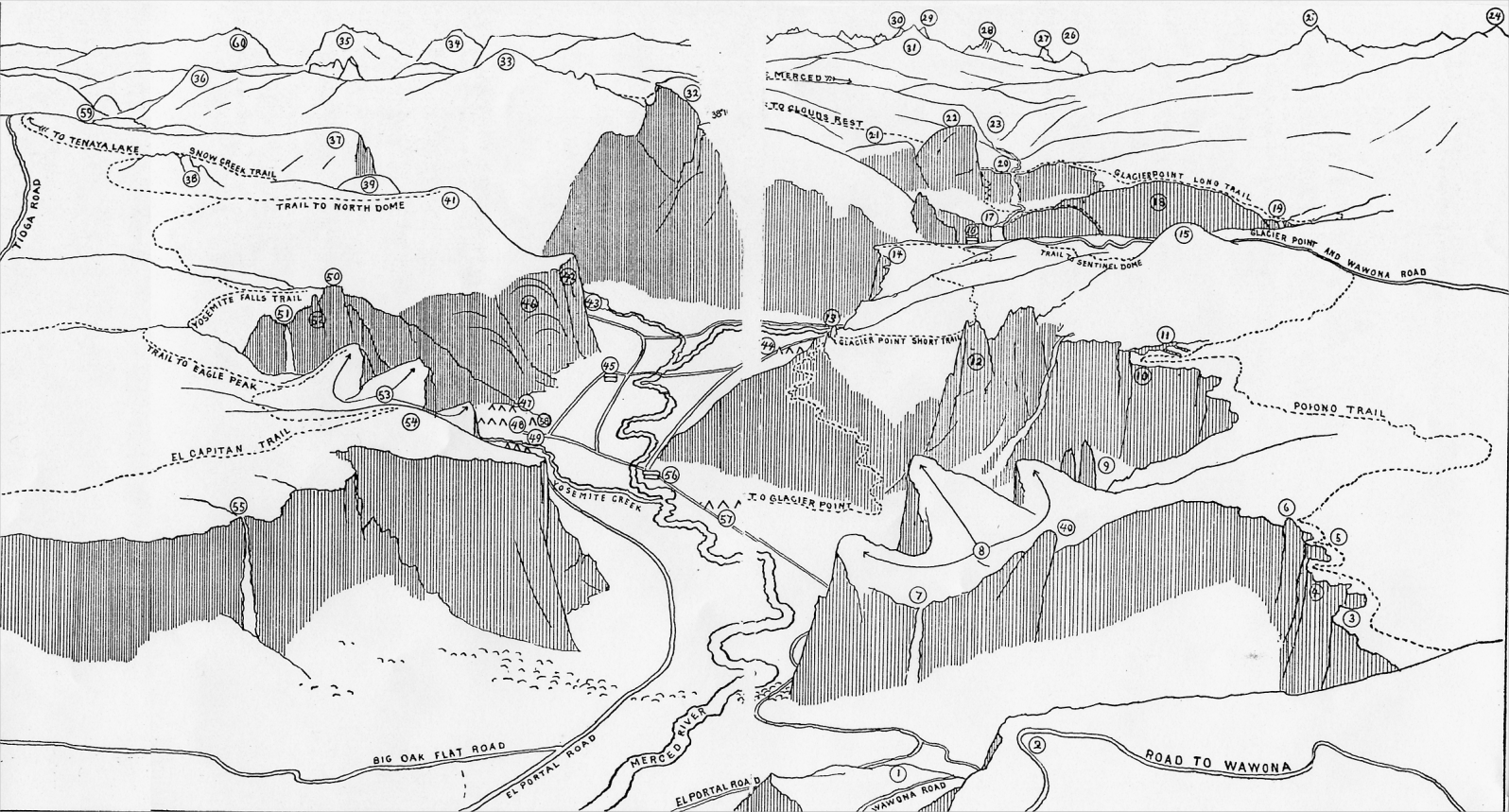
Note: The elevations given below are from maps of the United States Geological Survey. These maps do not always agree one with another, and even in the same map slight differences between the legend and bench-mark figures are sometimes found. Such variations, however, are inconsiderable,—never more than a few feet. Where they occur, the authority of the latest map, the "Panoramic View of the Yosemite National Park," has as far as possible been followed.
The figures indicate height above sea-level. For height above the floor of Yosemite Valley, deduct 3,960 feet, the elevation of the pier near the Sentinel Hotel. In the case of waterfalls, the height, or "drop," of each is given, as well as its elevation above sea-level.
|
1. Artist Point, 4,701 feet.
2. Inspiration Point, 5,391. 3. Old Inspiration Point, 6,603. 4. Stanford Point, 6,659. 5. Crocker Point, 7,090. 6. Dewey Point, 7,316. 7. Bridal Veil Fall, top, 4,787; drop, 620. 8. Cathedral Rocks, 6,638. 9. Cathedral Spires, 6,114. 10. Taft Point, 7,503. 11. The Fissures. 12. Sentinel Rock, 7,046. 13. Union Point, 6,314. 14. Glacier Point, 7,214. 15. Sentinel Dome, 8,117. 16. Glacier Point Hotel. |
17. Vernal Fall, top, 5,049; drop, 317.
18. Panorama Cliff, 6,224. 19. Illilouette Fall, top, 5,816; drop, 370. 20. Nevada Fall, top, 5,910; drop, 594. 21. Mt. Broderick, 6,705. 22. Liberty Cap, 7,012. 23. Little Yosemite, 6,150. 24. Mt. Star King, 9,181. 25. Mt. Clark, 11,500. 26. Foerster Peak, 12,062. 27. Electra Peak, 12,462. 28. Rogers Peak, 13,006. 29. Mt. Lyell, 13,090. 30. Mt. McClure. 31. Mt. Florence, 12,507. 32. Half Dome, 8,852. |
33. Clouds Rest, 9,924.
34. Parker Peak, 12,850. 35. Gibbs Mountain, 12,700. 36. Tenaya Peak, 10,200. 37. Mt. Watkins, 8,235. 38. Indian Rock, 8,526. 39. Basket Dome, 7,602. 40. Leaning Tower, 5,863. 41. North Dome, 7,531. 42. Washington Column, 5,912. 43. Mirror Lake, 4,096. 44. Camp Curry. 45. Kennyville. 46. Royal Arches, 5,500. 47. Indian Camp. 48. Camp Lost Arrow. |
49. Camp Yosemite (Military).
50. Yosemite Point, 6,935. 51. Yosemite Falls; Top of Upper Fall, 6,525; drop, 1,430. Top of Lower Fall, 4,420; drop, 320 52. Lost Arrow. 53. Three Brothers, 7,773 (Eagle Peak). 54. El Capitan; Brow, 7,042; summit, 7,564. 55. Ribbon Fall, top, 7,008; drop, 1,612. 56. Sentinel Hotel, Yosemite Village, 3,964. 57. Camp Ahwahnee. 58. Garage. 59. Lake Tenaya, 8,146. 60. Dana Mountain, 13,050. |
![[Yosemite]](/images/yosemiteicon.png) Copyright © 2004
Copyright © 2004