[click to enlarge]
| Online Library: | Title | Author | California | Geology | History | Indians | Muir | Mountaineering | Nature | Management |
Yosemite > Library > YNN > YNN 46(2) > Where Water Flowed ‘Uphill’ on Pothole Dome >
Next: Illuminated Valley • Contents • Previous: Washington Burn

[click to enlarge] |
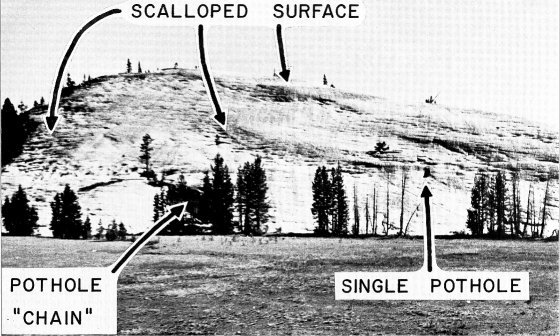
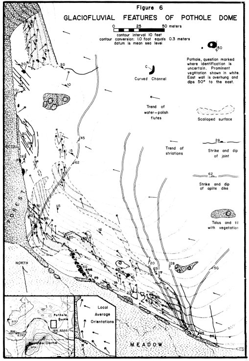
| Figure 1. Photograph of the southwest. flank of Pothole Dome taken in the early morning from Tioga Road shows accentuated shadows of undulatory scalloped surfaces as well as some of the larger potholes. Ice flowed from right to left. Compare this photograph with the map of Pothole Dome shown in Figure 6. |
[click to enlarge] |
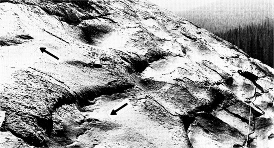
| Figure 2. A scalloped surface on the west flank of Pothole Dome. The tape measure is 7.6 m long and is oriented parallel to ice flow which was toward the reader. Subglacial water flowed toward the reader on nearly horizontal surfaces and diagonally upslope on steeper surfaces as shown by the arrows. Why the water changed direction in this way still remains a mystery. |
Richard Balogh
Situated at the western edge of Tuolumne Meadows and only a short walk from Tioga Road is a small roche moutonnee called Pothole Dome. (See Figure 1 and the index map in the lower left corner of Figure 6). As its name implies, this dome exhibits potholes - 41 in all - on its southwest and west facing flanks. Potholes are common erosional features of subaerial drainages world wide and are formed as stones are rotated by a swiftly moving current. Eventually a cylindric or conically-shaped hollow is ground into the stream bed.
The origin of the potholes on Pothole Dome is puzzling because no stream could possibly have flowed on the steep slopes of the rock. One hypothesis for their formation explains them as the result of glacial moulin plunge-pool erosion (Charpentier, 1841; Upham, 1900, p. 31; Gilbert, 1905, p. 317-318; Hollingworth, 1951, p. 40; and Faegri, 1952, p. 25). Moulins are vertical tunnels in glaciers through which surface water falls. The water descends to varying depths within the glaciers and when the bed of the glacier is reached, potholes are sometimes eroded. Few geologists still accept the moulin hypothesis, however, because vertically plunging water does not rotate grinding stones as well as does water entering obliquely. This has been demonstrated in laboratory experiments (Alexander, 1932, p. 310-312, 316 and 337) and indirectly by the lack of erosion of potholes by waterfalls (Angeby, 1951, p. 25).
During the summer of 1975 new evidence was found by the author on Pothole Dome which supports a subglacial stream origin. The system of of melt water drainage in a glacier during the melt season consists of three parts: surface flow (superglacial); flow wholly within the ice (englacial); and flow bounded by bedrock and ice (subglacial). The only flow in direct contact with the bedrock was subglacial — an important fact regarding the origin of the potholes. The evidence found on Pothole Dome shows that subglacial water did in fact flow over the dome and quite possibly did erode potholes in the process.
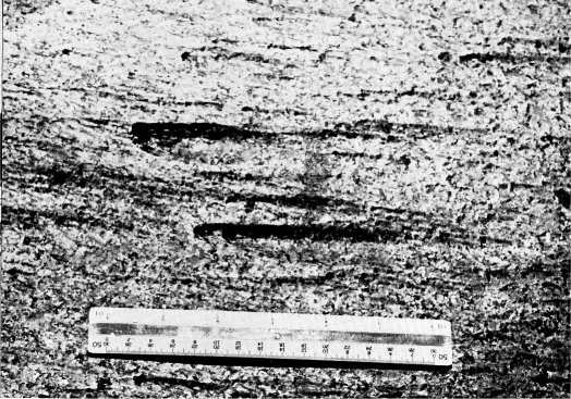
On Pothole Dome in the morning when the shadows are long, two types of hollows different from potholes are observed. One type collectively forms an undulatory topography termed a scalloped surface (Balogh, 1976, p. 20) as shown in Figures 1 and 2. G. K. Gilbert referred to it as “peculiar flexuous sculpture” and thought each hollow was the surviving part of a partly ice-walled pothole produced by moulin plunge-pool erosion (1905, p. 319). The hollows of the second type are very small and would be unnoticed by the casual observer. They are small flutes, rarely longer than 4.0 cm and only 1.0 mm or less in depth. Each flute is an elongated hollow that initiates at a mafic mineral grain. Flutes identical in shape are found in many subaerial water courses in the Sierra. The flutes can be considerably larger than those on Pothole Dome, as shown in Figure 3. Each flute is the result of turbulent water flow which has initiated erosion at a cavity in the rock surface. Abundant cavities are
[click to enlarge] |
| Figure 3. Subaerial flutes in Half Dome Quartz Monzonite bedrock on the Tuolumne River near Pothole Dome. Water flowed from left to right. Note that each flute originates from a weathered biotite or hornblend crystal and flares, or opens, in the direction of flow. Such fluted surfaces are glass smooth. Scale is graduated in inches (1.0 inch equals 2.54 cm). |
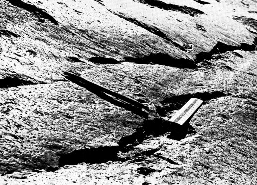
The flutes on Pothole Dome clearly indicate water flowing upslope (see Figure 4) which is not possible for subaerial drainage. Pressures in the ice must have been unusual for subglacial water to have flowed over the dome. According to theory, subglacial water can flow over bedrock protuberances such as Pothole Dome if the glacial ice surface slope is sufficiently large (Shreve,1972, p. 211).
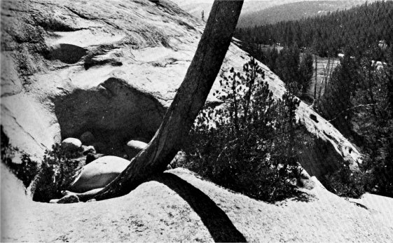
Although flowing water is capable of eroding small flutes, grinding stones and irregularities in the bedrock surface are required for the formation of potholes. Since a glacier’s bed commonly contains rock fragments of various sizes, the necessary grinding stones were, probably taken from this source. Well-rounded grinding stones are still preserved in a few potholes on Pothole Dome as shown in Figure 5. Bedrock surface irregularities are very numerous and of many shapes and sizes. However, most potholes have formed in the lee of bedrock steps. The best example is the pothole “chain” shown in Figure 5 and mapped in Figure 6. Twelve potholes have been eroded into the lee wall of what appears to be an exfoliation flake. Laboratory experiments have shown that where water flows over a downward step on the bed, vorticity, or eddying, is produced (Allen, 1971). The twelve potholes in the chain are located where the vorticity would have been strongest. Vorticity required for potholes not
[click to enlarge] |
| Figure 4. Subglacial water flutes and striations on Pothole Dome. Flutes flare toward the upper left, parallel to the pencil, whereas striations trend parallel to the scale. The flutes indicate that subglacial water flowed up this 25-degree slope from lower right to upper left. The ice flowed toward the reader. Length of the scale is 17.0 cm. |
Figure 6 summarizes the glaciofluvial features (features due to sub-glacial water erosion) as well as the trend of glacial striations (which indicate ice flow direction) and bedrock features (joints and dikes) on the southwest and west flanks of Pothole Dome. The two features, termed curved channels in Figure 6, are not potholes. They are one variety of a large group of subglacially produced hollows collectively known as plastically-molded forms or p-forms. See Balogh (1976) for a discussion of p-forms in the Tuolumne region.
Pothole Dome is not the only example of glaciofluvial erosion in the Tuolumne region. During the summer of 1975, 279 potholes-of definite subglacial origin were found in the southwest quarter of Tuolumne Meadows Quadrangle. Because there is extensive field evidence for glaciofluvial erosion in the Tuolumne area and because Pothole Dome is so accessible to the Park visitor, this author encourages the placement of an interpretive sign at the Pothole Dome turnout on Tioga Road describing glaciofluvial features. The fascinating origin of the potholes could then be explained to all interested visitors.
[click to enlarge] |
[click to enlarge] |
| Figure 5. Subglacial pothole chain on Pothole Dome (mapped in Figure 6). Well rounded, spherical grinding stones are preserved in the pothole at left. Scale resting on the largest stone is 17.0 cm long. Ice flow was toward the reader. Bedrock is Cathedral Peak Granite. This pothole chain is located in the lee, with respect to ice flow, of a downward step. Evidently, this step is the edge of an exfoliation sheet but no trace of a joint was observed here, although some are shown in the distance just to the right of the largest tree in the foreground. A different set of shallowly dipping exfoliation joints is exposed on the slope and in the wall of the pothole at left. |
Alexander, H.S., 1932, Pothole erosion: Jour. Geol., V. 40, p. 305-337.
Allen J. R. L., 1971, Transverse erosional marks of mud and rock; their physical basis and geological significance: Sed. Geol., V. 5, No. 3-4, p. 165-385.
Ängby, O., 1951, Pothole erosion in recent waterfalls: Lund Studies in Geography, Ser. A, No. 2, p. 1-34.
Balogh, R. S., 1976, Subglacial fluvial erosion in the vicinity of Tuolumne Meadows, Yosemite National Park, California: unpublished Masters Thesis, University of California, Los Angeles, 61 pages. (a copy of this work is in the Yosemite Research Library)
Charpentier, J. F., 1841, Essai sur les glaciers: Et sur le terrain erratique du bassin du Rhône. Lausanne, M. Ducloux. [Editor’s note: Test on Glaciers: And on erratic terrain of the Rhône basin —dea.]
Faegri, K., 1952, On the origin of potholes: Jour. Glaciology, V. 2, No. 11, p. 24-25.
Gilbert, G. K., 1906, Moulin work under glaciers: Bull. Geol. Soc. Am., V. 17, p. 317-320.
Hollingworth, S. E., 1951, Potholes and glacier mills; some comments on Dr. Streiff-Becker’s article: Jour. Glaciology, V. 1, No. 9, p. 490.
Shreve, R. L., 1972, Movement of water in glaciers; Jour. Glaciology, V. 11, No. 62, p.205-214.
Upham, W., 1900, Giant’s kettles eroded by moulin torrents: Bull. Geol. Soc. Am., V.12, p. 24-44.
Next: Illuminated Valley • Contents • Previous: Washington Burn
| Online Library: | Title | Author | California | Geology | History | Indians | Muir | Mountaineering | Nature | Management |
http://www.yosemite.ca.us/library/yosemite_nature_notes/46/2/pothole_dome.html