PLATE VI
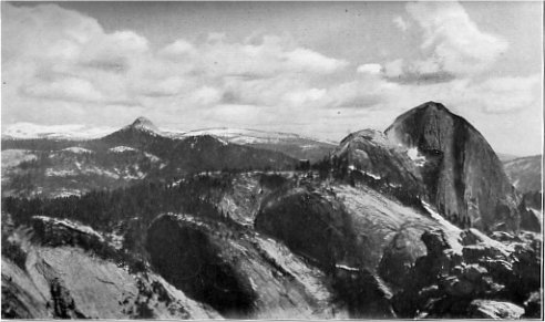
Two Yosemite domes. Mount Star King (left) and Half Dome (right) from the summit
of Mount Watkins
Photo by A. D. Lockwood
| Online Library: | Title | Author | California | Geology | History | Indians | Muir | Mountaineering | Nature | Management |
Yosemite > Library > Handbook > Geology >
Next: Life Zones of Yosemite • Contents • Previous: Administration of Yosemite
By Andrew C. Lawson
Professor of Geology and Mineralogy, University of
California
From a geological and physiographic point of view the Sierra Nevada is, as its Spanish name implies, a single range built on very simple structural lines. It belongs to the class of mountains of the Basin Range type, so called because it is best exemplified in the Great Basin, that great region of no drainage to the sea which lies between the Sierra Nevada and the Wasatch. In this region the earth’s crust has been broken into blocks, elongated in a general north-south direction. Some of these have been depressed and lie beneath the broad valleys of the desert, while others have been uplifted and constitute its linear mountain ranges. The uplift has, however, not been uniform in most cases, but has been effected by a rotation of the block On an axis parallel to the range. It results from this that the block as a whole has been tilted so as to Present a steep front, or scarp, on one side and a gentle slope on the other. The simplicity of the Profile thus produced has of course been greatly modified by the erosion of the block which has taken place irl the long period of time that has elapsed since its uplift.
The Sierra Nevada is one of these uplifted and tilted blocks, presenting a very steep, bold front to the east and a slope of only about 2° to the west. The edge of the tilted block is the crest of the range; its eastern front is the surface of the break whereby it was dislocated from the relatively depressed region of the desert; and its western slope represents the old, low surface of the region before it was elevated. Both the eastern front and the western slope have suffered greatly from erosion since the range came into being by this process of uplift and tilting. On the east the fault scarp has been battered to a slope much less steep than it was originally, and the crest of the range has thereby migrated westward. On the west the tilting of the surface determined a drainage by streams running transverse to the axis of the range; and these, by reason of their velocity, cut sharp trenches, which in the course of time have been deepened and widened into the great cañons of the Sierra Nevada. On the divides between the cañons, in cases where their slopes have not yet intersected, there are still remnants of the old surface much in the same condition as it was before the uplift. From these flat-topped divides, an observer may get such extended views in all directions that he forgets he is in the mountains, and, overlooking the deep cañons, gets the sensation of being on a vast sloping plain with occasional low hills rising above the general surface. It is this plain which has a slope of 2° from the edge of the Great Valley to the region of the summit peaks and crests. Its remarkable evenness on many of the divides, particularly in the northern part of the range, is due to the fact that the region before its uplift was extensively covered by deposits of meandering streams, and these in turn covered by layers of volcanic ash, agglomerate, and lava, thus smoothing out and obscuring the inequalities of an erosional surface of comparatively low relief. Considered in the light of these observations and viewed in its entirety, the Sierra Nevada is recognized not only as one of the Basin Ranges, but as the most perfect and most magnificent example of the type.
The uplift of the Sierra Nevada was not, however, a simple sudden event, nor even a continuous process of earth deformation. The uplift proceeded by stages of which two are strongly pronounced, particularly in the southern part of the range. Between these stages the process of tilting stopped for a long time, and in the interval the cañons, which had been deepened to the limit for the first stage, were widened into broad flat-floored valleys. As a consequence of the second stage of uplift, the streams flowing through these wide valleys were rejuvenated and resumed the work of cañon cutting, leaving large remnants of the old valley floors as benches or terraces above the brink of the cañon walls. The high valleys that border the cañon of the Kern are perhaps the best records of this Period of stability in the Sierra Nevada between two stages of uplift. The wide, level, rock floor of Tuolumne Meadows, by its contrast with the gorges of Tenaya Creek and Tuolumne River below the Meadows, suggests that it, also, may have been developed in its preglacial outlines, during this same period of stability.
The uplifting process of the second stage is not yet completed. In 1872, at the time of the heavy earthquake of that year, a movement occurred on the great fault which bounds the Sierra Nevada on the east. By this movement the elevation of the southern part of the range, in relation to Owens Valley, was increased by about twenty feet; and a fresh scarp was formed, causing a sharp step in the profile of the lower flank of the range.
Having now acquired an understanding of the general configuration of the Sierra Nevada as a single mountain of the Basin Range type, formed by the tilting of an elongated block of the earth’s crust, we may proceed to consider the cañons which have been cut into the rising mass, and particularly the cañon of the Merced with its famous Yosemite Valley. With one notable exception the great cañons of the Sierra Nevada are transverse to the range. The dominant drainage still follows the lines imposed upon it consequent upon the tilting of the crustal block. In this respect the drainage pattern differs in a marked degree from that of many other mountain ranges. The main valleys and stream courses of the Appalachian Range, for example, are parallel to the length of the elevated mass, with only short transverse outlets for the extended longitudinal system. Similarly the main drainage of the Coast Ranges is parallel to their elongation. The reason for this is that in these and similar mountain ranges the belts of rock conform in direction to the elongation of the range, and belts of soft rock generally alternate with belts of hard rock; so that, although the drainage may have been originally transverse, consequent upon the uplift, the tributaries of these consequent streams that happened to be on belts of soft rock eroded cañon’s very much faster than those which drained belts of hard rock, and faster than the consequent streams, which traversed both hard and soft belts. The result of this has been that, in the course of time, the great valleys of old mountains become located in the soft belts, and so become the dominant features of the drainage systems. Such longitudinal drainage is technically designated subsequent to distinguish it from the earlier transverse or consequent drainage.
The reason that no notable subsequent drainage has been developed in the Sierra Nevada is twofold: 1. The time that has elapsed since the uplift of the range has been so short that, even in the northern part of the range where the contrast of hard and soft belts is pronounced, the tributary streams have as yet made but little headway in establishing their domination. Geologists and geographers regard a well developed subsequent drainage as characteristic of a relatively old mountain range. So we may classify the Sierra Nevada, on the basis of the meagerness of subsequent streams, as a young mountain range. 2. In the southern part of the Sierra Nevada there are but few contrasts in the hardness of the rocks, the mass of the mountain being almost wholly granite, so that the condition favorable for the development of subsequent streams, on a well-marked longitudinal pattern, is lacking.
The notable exception to this transverse disposition of the Sierran streams is the Kern River. This stream, however, had its position determined for it by a remarkable rift in the earth’s crust, parallel to the great fault which marks the eastern boundary of the range.
Long after the uplift of the Sierra Nevada to practically its present altitude, after the cañons had been eroded down to very nearly their present depth below the flat-topped divides, the climate changed for the worse. In the summit region the ablation of summer failed to remove the snows of winter. The snows of many years accumulated and became packed down of their own weight into ice, so that glaciers were formed. At first these were small and situated on the north side of the great peaks where ablation was feeble; but later they expanded into great névés from which tongues of ice extended down into the cañons. These tongues were veritable streams of ice many hundreds, and even thousands, of feet deep, which flowed slowly through the cañons for ages. They extended far below the line of perennial snows, and in each case reached a limit, at the time of maximum severity of climate, at a point in the cañon where the ablation of summer just balanced the forward flow of the ice. At this point the glacier dumped the load of rock débris which had been shed upon it from the cañon walls above. Thus a great lunate ridge of fragments, ranging in size from grains of sand to spauls the size of a house, was formed, spanning the cañon from wall to wall. This ridge is called a terminal moraine; and there are many such moraines in the great cañons. Besides the terminal moraine, there are others farther up the cañons, called moraines of retreat, which mark stages in the waning of the glaciers when the climate again became more genial. To these moraines were delivered not only the rock, fragments which had ridden on the back of the glacier to its end, but also similar fragments carried in the body of ice, which had either fallen into crevasses or had been plucked out of the floor of the cañon in places where the rock was so intersected by joint cracks as to be divided into blocks, and so easily dislodged by the ice stream. Many rock fragments were also carried
|
PLATE VI Two Yosemite domes. Mount Star King (left) and Half Dome (right) from the summit of Mount Watkins Photo by A. D. Lockwood |
Besides the terminal moraines and moraines of various stages of retreat, the upper slopes of the cañons formerly occupied by glaciers are in many cases, particularly near their headwaters, modified by great ridges of glacial débris, known as lateral moraines. These accumulations were formed in the same way as the terminal moraines due to a sideways movement of the ice to balance the ablation along its margin.
The effect of the long continued flow of these ice streams upon the configuration and aspect of the cañons is very notable, and may be observed in the upper reaches of all the great Sierran cañons. In their lower stretches, the cañons are all V-shaped in transverse profile, the slopes are uneven and generally encumbered with a mantle of rock débris and soil arising from the disintegration and decay of the rock tinder the weather. Where rock surfaces are exposed these present the appearance of fractures, or are bounded by joint planes, and the rock is usually somewhat decomposed for a short distance below the surface. As we pass up the cañons, within the limits of former glaciation, the whole aspect of the landscape changes. The cañons are no longer V-shaped in profile, but more nearly U-shaped. All of the rock débris and soil has been swept out of the cañon, and bare rock surfaces are seen on every hand. These surfaces are, moreover, not commonly fractures or joint planes, but are clearly surfaces due to abrasion since they show abundant evidence of scoring, striation, fluting, and polishing. Many surfaces are so highly polished that they reflect the sun’s rays like a mirror. Where the polish is lacking it is generally evident that this is due to exfoliation, the scaling off of the rock in thin slabs, and that the polish once extended over the areas thus denuded. The bare rock surfaces have acquired rounded or hummocky forms which, from a distance and in the aggregate, look like the backs of sheep in a flock. They are therefore known technically as roches moutonnées. The hummocks are characteristically elongated in the direction of the cañon and have a symmetrical transverse profile but an asymmetrical longitudinal profile, with a steep front facing down stream. This asymmetry is due to the fact that the upstream side of the hummock received the full force of the abrasive impact of the ice current, whereas the tendency on the downstream side was to pull out or pluck fragments from the rock mass and so leave a steep front. The abrasion thus so apparent on the roches moutonnées affected all surfaces over which the ice passed. It was not done by the ice itself, however, but by the rock fragments imbedded in it. The passage of the ice stream through the cañons not only swept away all loose rock and soil on the slopes, but by this process of abrasion removed all the decomposed material, so that the rocks so generally exposed in the glaciated Portions of the cañons are in a wholly sound and fresh condition. It is evident also that the abrasive process was competent to reduce even the fresh hard rock after the superficially decomposed material had been removed. The long continued abrasion and the plucking together have deepened the cañons, at the same time giving them their characteristic U-shaped profile. One of the finest examples of the effect of ice upon the configuration of a cañon, once merely a stream gorge, is afforded by Tenaya Cañon, a good general view of which may be had from Mirror Lake.
The power of glaciers to deepen the cañons in which they flow is perhaps best exemplified in their upper reaches where the general grade is steeper. Here the characteristic longitudinal profile of the cañons is a series of steps, the present streams cascading from one level to another. On each step is a rock-rimmed basin, or tam. In some cases there may be several such steps and tarns in the course of a mile, while in others the steps may be much broader and more widely spaced. No other agency is known whereby these tarn basins could have been formed except by the abrasive power of rock-laden ice. Seizing upon the inequalities of the original stream profile the ice has accentuated these into a series of giant steps, the treads of which suffered heavy local abrasion by the impact of the ice descending from above, while the risers were developed into cliffs by exceptionally active Plucking. One of the lowest of the tarns in the vicinity of Yosemite is Tenaya Lake which lies in a rock-rimmed basin 140 feet deep.
Another extremely interesting feature of most glaciated cañons, to be found at their very head, where the ice stream has its origin, is the cirque. This is a vast amphitheatre of bare rock enclosed by nearly vertical cliffs, generally hundreds of feet high, in the floor of which is a tam. In some of the larger cirques there are several tarns at slightly different levels. These cirques appear as great bites in the mass of the mountain and are clustered around the high peaks of the summit that divide the drainage. They have been formed by that peculiarly vigorous process of ice erosion which, on a smaller scale, has given us the steep faces of the roches moutonnées hummocks, and the risers on the steps of the glaciated cañons. The glaciers at their heads ate their way into the mountain mass, by nibbling at the base of the cliffs and so undermining them. The blocks of rock plucked out from the cliffs were incorporated into the ice and carried away by the glacier to be delivered chiefly on its sides, to make the great lateral moraines which are now found below the cirques. As the process proceeded, and the cirques were enlarged at the expense of the peaks and ridges, the divides between opposing cirques were in many cases reduced to thin partitions with sharp knife-like crests. As still further enlargement proceeded, these divides were rapidly lowered. We have thus presented to us in this encroachment of cirques, one on the other, a process whereby lofty mountain crests and summits are first gradually narrowed and then rapidly reduced. This glacial destruction of mountain crests may eventually so lower the elevation that the conditions favoring the accumulation of ice may be done away with. Alpine glaciers may therefore be said to be self-destructive. The glaciation of the high Sierra, however, occupied but a brief time from a geological point of view and before the destruction of the high peaks and summits had proceeded far the climate changed and the glaciers almost wholly melted away, leaving only remnants in a few of the higher cirques.
Of these lingering glaciers within the limits of the National Park the most notable, as well as the most accessible, are those on the east side of Mt. Dana, on the north side of Mt. Lyell, and on the northeast side of Mt. McClure. These glaciers are very small compared with the great ice stream that once filled the whole of Tuolumne Meadows, and sent one tongue down the cañon. of the Tuolumne River far below Hetch Hetchy and another down Tenaya Cañon into Yosemite. They are, however, interesting features of the high Sierra and well worth a visit. Although they are very small, they have all the essential features and functions of their great ancestors except that they are in some cases broader than long. Here at the lower edge of the ice one may see a moraine in actual process of accumulation; and on searching among the bowlders one may find some that have been abraded and scratched. The ice is traversed by crevasses just as in the case of the great glaciers and riding on the ice may be seen the débris shed from the cliffs above. If we cross the glacier to its upper edge where it appears to adhere to the base of the cirque walls, we find that the appearance is deceptive, for the ice, instead of hugging closely the base of the cliffs, is separated from them by a space of several feet. The space extends down for a long distance between the wall of rock and the wall of ice as a great chasm. This detachment of the glacier from the cliffs is known as the bergschrund. At the bottom of the chasm goes on the plucking and sapping action which gives the cirque walls their verticality, as seen when the ice eventually vanishes.
Among the glaciated cañons of the Yosemite National Park those of the Merced and the Tuolumne are the most impressive and the most interesting. just as at present these two streams gather up and carry forward to the San Joaquin Valley practically all the drainage of the park, so, in glacial time, the great bodies of ice which covered the summit region within the limits of the park, excepting the highest peaks, converged on the same two cañons, and flowed down them to the limit where ablation balanced the forward movement. Some of the ice, however, flowed through the passes on the crest of the range toward the east and gave rise to glacier tongues on that side which were much shorter than those on the west; because then, just as now, the climate was much drier and the summers hotter than on the west side of the summit. Most of these short glaciers on the eastern flank of the range have left splendidly developed lateral moraines. Some of these, particularly those of Bloody Cañon, Leevining Cañon, and Parker Creek, in the vicinity of Mono Lake are easily accessible to visitors in the park. It is interesting to note that, at the maximum extension of these east flank glaciers, the level of Mono Lake was about 675 feet higher than at present. At this high level the glaciers reached the lake. But even under these conditions the greatly increased influx of water from the melting glaciers was balanced by evaporation, for at its highest stage Mono Lake had no outlet. Thus we have the apparent anomaly of glaciation combined with aridity. The explanation of course is that the glacial streams flowed from a humid region west of the crest of the Sierra Nevada into an and region to the east of the crest. The line between two strongly contrasted climatic provinces was, however, very sharp.
In the drainage system of Merced River Tenaya is perhaps the most typical illustration of a thoroughly glaciated stream gorge. It is at the same time the most easily accessible to visitors in the Yosemite Valley. Everybody who goes to Yosemite gets a glimpse of Tenaya Cañon from Mirror Lake. Yosemite is also a glaciated cañon. There is a large moraine spanning the Valley just below El Capitan and the ice must have extended that far at least. Yet the contrast between Tenaya Cañon and Yosemite Valley is very great. If Tenaya be the type of a glaciated cañon, Yosemite must be abnormal. In what does the departure from the type consist? Evidently in the width of the Valley floor, its level character, and the entire absence of bare rock surfaces. The floor of Yosemite is everywhere sandy and there is reason to believe that the deposits of sand are several hundred feet thick. If we imagine this sand removed and the talus at the base of the great cliffs nonexistent, we would see the Valley as it actually was immediately on the retreat of the glacier. The picture before the mind’s eye would then differ in no essential respect from the view we get of Tenaya Cañon. The Valley would then be true to type. It would be larger and deeper, but there are good reasons for this. The glacier entering Yosemite from Tenaya was not the Only one that filled the Valley with ice. An equally important one flowed in from the Upper Merced and Little Yosemite; and another moved down the Illilouette. These three great glaciers converged on Yosemite and the cross section of the confluent glacier in the Valley was probably not less than the sum of the cross sections of the three tributaries. This great increase in the volume of the ice, particularly as expressed in its depth, together with the steepness of approach of the tributaries to the Valley, would greatly increase the abrasive action of the glacier on its floor. Just below the confluence, that is in Yosemite, the cañon would be over-deepened and we would have a rock-rimmed basin formed, like that of Tenaya Lake but larger and deeper. Thus, in our mental picture of the restoration of Yosemite as it was at the immediate retreat of the glacier, we must introduce a beautiful lake, in which were mirrored the majestic walls encircling it. At the lower end of this lake, just below El Capitan, had been left a moraine which helped to accentuate the depression caused by the scour of the ice. Into this lake poured the sandy and milky waters of the three glaciers, now separate during the long period of their retreat. These streams built out a delta into the lake which eventually filled it, giving us the present floor of the Valley, seven miles long and one mile wide. On this floor has accumulated the talus of rock spauls shed from the cliffs; and across the floor in a shallow sandy trench flows the Merced River, cascading over the moraine below El Capitan, giving us the Valley as we know it to-day.
Hetch Hetchy Valley is generally recognized as being analogous to Yosemite though on a small scale. The profound gorge of the Tuolumne, with it stepped profile of bare, glaciated rock emerges suddenly on a wide, flat-floored, sandy valley, just Tenaya Cañon opens on Yosemite. Both valleys have had the same history. Glacial abrasion and plucking over-deepened the cañon, so that, when the
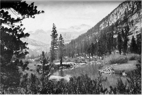
PLATE VII The Lyell Canyon with Mount Lyell and its glacier several miles distant Photo by Wm. E. Colby |
Little Yosemite Valley owes its flat, sandy floor and its breadth between walls to the same process. The valley is but a tread on the great stepped profile of the Merced; and on this tread there had been scoured out a rock-rimmed basin which, on the final retreat of the ice, contained a tarn about three miles long. Several meadows in Tenaya Cañon above Tenaya Lake are similarly filled tarns, as are also many meadows of the higher altitudes.
The contrast between the typical glaciated cañon of Tenaya Creek, and the aberrant Yosemite and Hetch Hetchy valleys is not, however, due wholly to the fact that they once held lake basins now filled with sand. The contours and the profiles of the walls of both Yosemite and Hetch Hetchy differ from those of Tenaya Cañon. The contours of Yosemite are in general zig-zag, expressive of salients and reëntrants which are full of surprises and suggest some mysteriously intentional process of sculpture. In the profiles the vertical element dominates and gives the Valley its atmosphere of solemnity and majesty, the same atmosphere which the great architects of the Middle Ages gave to their splendid Gothic cathedrals. These features are in striking contrast with the smoothly flowing, though undulatory, contours and profiles of Tenaya Cañon below Clouds Rest as seen from Mirror Lake. When we try by close observation to ascertain the cause of this contrast we discover, as Matthes has so well told us, that in the sculptural modification of the Valley by glacial erosion there has been a large element of control inherent in the structure of the granite, which is the prevailing rock. The granite originally solidified from a molten condition under a cover of immense thickness. This cover was removed by erosion ages before the uplift which gave the Sierra Nevada its present configuration. The relief of load, as erosion proceeded, and the lowering of the temperature of the mass as the granite was brought nearer the surface and eventually into the zone of erosion, greatly changed the condition of compressive strain which the force of gravity imposes upon the rock. This redistribution of strain caused certain portions of the mass to be overstrained, and relief was obtained by the development of systems of cracks or fissures which we call joints. These joints are in some cases straight and parallel so as to divide the rock into thick slabs, as on the face of Sentinel Rock. In other cases there are two or three intersecting systems which divide the rock into prisms, or cuboidal, or rhomboidal blocks. In still other cases the joints are curved and roughly concentric as at the Royal Arches. Many portions of the granite are, however, almost free from joints, or, if they be present, they are so widely spaced that they only slightly affect the integrity of the rock, as at El Capitan.
Now, nearly all of the vagaries of erosion, a particularly of ice sculpture, in Yosemite Nation Park are referable to the erratic distribution of these systems of joints and to the disposition of the joint planes in each system. The ice, in passing over or past jointed granite, plucked out the blocks one by one and incorporated them within its body, carrying them forward with the glacial flow. In the course of time a vast quantity of rock was thus removed. In the unjointed portions of the granite in contact with the ice, on the other hand, erosion was limited to abrasion and comparatively little rock was removed by this process. In this way there were large differences in the rate of glacial erosion in near-by localities; and the same influence had also affected ordinary atmospheric and stream erosion in the ages that preceded the glacial period. The great salients like El Capitan are composed of granite in which the joint structure is but feebly developed and were, therefore, resistant to erosion by the dislodgment of blocks. The trough in which Bridalveil Creek flows above the falls is clearly conditioned by the intersection of inclined joints. The great steps over which Vernal Falls and Nevada Falls tumble are equally clearly determined by the disposition of the joint planes there. In the exfoliation of the curved slabs, so well exemplified in the Royal Arches, we have an excellent illustration of the control exercised by curved joints in the development of the great domes of the park, such as North Dome, Half Dome, and many others. The curious spires which are so common about Tuolumne Meadows, and which characterize the landscape in the wonderful view from the summit of Mt. Conness, owe their configuration to the same control of erosion by internal structure. It is well to note, however, that the curved joints which determined the configuration of the domes and spires presented a structure which was not so favorable to dislodgment of spauls, whether by atmospheric agencies or by glacial plucking as was the structure formed by intersecting straight joints The domes and spires represent portions of the granite which were, like the unjointed rock, relatively resistant to mechanical disintegration, so that, when the rest of the region was reduced in level, they remained as eminences. The higher domes and spires probably rose well above the surface of the great névé and the ice streams flowing from it, so that the exfoliation which gave them their present configuration is referable not to ice plucking, but to the heaving action of freezing water in the joint cracks, and to the slow, recurrent movements due to dilatation and contraction under varying temperature. Half Dome, the asymmetry of which, no less than its isolation and height, makes it so conspicuous a feature of Yosemite Valley, owes its peculiar configuration to the intersection of two systems of joints: a system of straight, vertical joints parallel to the flat west face, probably disposed in a narrow zone, and a system of curved joints concentric with the rounded east side.
Many of the lower domes have, however, been over ridden by the ice and so have had a glacial modelling, by abrasion, imposed upon surfaces originally wholly determined by curved joints. In this process a glacial modelling great thick slabs of granite which had become loosened from the parent mass were plucked out by the ice, leaving vertical walls from a few inches to twenty feet or more high facing down stream. The ice immediately flowed into the reëntrants thus formed and abraded the new surface exposed to its attack by the removal of the slab. In cases where this happened during the retreat of the ice front we find abundant manifestations of glacial scouring at sharply different levels on the bare rounded surfaces. Some extreme cases of this sort have suggested to Mr. Matthes that there may have been two glaciations of the region, and he has adduced other evidence in favor of this view. In this he is supported by the earlier interpretation of the moraines near Mono Lake by Russell; by the observations of Turner and Ransome in the Big Trees quadrangle; and by the later observations of Knopf on the eastern flank of the Southern Sierra Nevada. But the doctrine of two distinct glaciations of the Sierra Nevada is one which must be subjected to much more critical study before it can be accepted by geologists as an established fact. There is, of course, in this doubt as to the reality of two distinct glacial periods no objection to the recognition of frequent retreats and advances of the glacier front in one and the same glacial period; for we are familiar with such oscillations in the existing glaciers of Alaska, Norway, and the Alps.
Yosemite Valley differs from Tenaya Cañon in still other important features which excite not only geological interest, but also the wonder and admiration of all who come to the Valley. These are the waterfalls, the grace and beauty of which, no less than their great height, have made them famous the world over. Streams which flow with gentle gradients in comparatively shallow channels on the uplands corresponding to the old surface before it was uplifted, reach the brink of the Valley and plunge headlong into the abyss, clearing all contact with the cliffs for hundreds of feet. These upland channels which thus appear at the brink of Yosemite Valley as small notches in its walls belong to the class of so-called "hanging valleys," which are rather characteristic of glaciated regions in general. They may have one of two different origins: 1. The relatively shallow upland channels may have been nonexistent prior to the glaciation of the region, the drainage having then taken some other path. In this case the present position of the streams was determined by the configuration of the surface vacated by the ice, and their channels, in so far as these have been cut by water erosion and not by glacial scouring, is wholly a post-glacial effect. If this be the explanation of Yosemite and Bridalveil creeks then there is nothing surprising in the fact that, in the short time since the ice vanished, they have eroded but shallow trenches in the glaciated upland, and so appear as hanging valleys on the brink of the Valley. 2. The upland creeks that now cascade into the Valley at Yosemite Falls and Bridalveil Falls may have been preglacial drainage lines which were temporarily occupied by the ice with the rest of the country, and which again became functional when their channels were vacate, by the ice. In this case these two tributaries of the Merced must have been engaged in the work of stream erosion as long as the main stream and there should have been, just prior to glaciation, no glaring discordance in the depth of their trenches. If this be so, then the main cañon of the Merced at Yosemite Valley must have been very shallow just prior to glaciation, and nearly the whole depth of the Valley would have to be ascribed to glacial erosion. But we cannot accept this latter explanation because the cañon of the Merced below the limit of glaciation affords us the measure. of preglacial. erosion and tells us that Yosemite has been only modified and over-deepened by ice work, but not, in its larger features, created by the glacier.
It would seem, therefore, that both Yosemite Creek and Bridalveil Creek are post-glacial drainage features; although the argument applies with greater force to the former than to the latter. The same interpretation can scarcely, however, be placed on Illilouette Falls, and much less can it be applied to Vernal and Nevada falls on the main flow of the Merced. These three magnificent cascades clearly are on lines of pre-glacial drainage, and their relation to Yosemite Valley is not the same as that of Yosemite and Bridalveil falls. The drop from Little Yosemite and that from the upland valley of the Illilouette to the floor of Yosemite are nearly the same, and the gorge into which the waters tumble in both cases is a glacially modified inheritance of a pre-glacial condition. Attention has been called to the fact that the uplift of the Sierra Nevada took place by two main elevatory movements, with a long period of rest between during which the high valleys of the Kern region were evolved to their present notable width. It may well be that on the drainage system of the Merced there were also similar high valleys carved out of the mountain mass, and that Little Yosemite and upper Illilouette are remnants of this old topography. Such valleys after the second uplift would, of course, be subject to vigorous dissection by reason of the accentuation of the stream grades. This dissection, however, probably proceeded as it does In plateaus underlain by flat lying strata; that is, by the recession of falls so well exemplified at Niagara and by the falls of the Yellowstone. At Niagara the rocks are hard limestones resting on soft shales, while in the Yellowstone the strata are sheets of volcanic rock. But in both cases the gorge has been formed by the slow upstream recession of the falls. Horizontal jointing in the granite, such as is so well displayed near the top of Lower Yosemite Falls, and one third of the way up the walls of Hetch Hetchy, would have the same effect as planes of stratification in promoting this process of gorge cutting, particularly if combined with transverse vertical jointage, which would determine the verticality of the head of the gorge. Both horizontal and vertical jointage are well displayed in the gorge between Nevada Falls and the floor of the Valley.
We may thus picture to ourselves a pre-glacier Yosemite Valley, not as deep, nor as wide, nor as sheer-walled as the present Valley, but nevertheless profound erosional gorge ending in spray filled culs-de-sac below both Little Yosemite and the high valley of the Illilouette, with great cascades in them not essentially different from those we see to-day with so much pleasure and interest. Nevada,Vernal, and Illilouette are, therefore, from this point of view, falls which handed over their work of extending the cañon of the Merced into the High Sierra to the Merced Glacier for a geologically brief time, and have since resumed operations at nearly the old stand. The amount of recession effected by the glacier was probably not great, since the work must have been done chiefly, not wholly, by the process of plucking, and the paucity of the moraines below Yosemite indicates but a small product.
Pre-glacial Tenaya Cañon, in contrast to that of the Merced, was not extended upstream by a sapping process, but by stream corrasion through granite traversed by a zone of vertical joints parallel to its length, and deficient in horizontal and in transverse vertical joints. The gorge was narrow and steep, and although it doubtless had its cascades, these did not have the sheer drop displayed by the Nevada and Vernal Fails. The deepening of the cañon by stream corrasion was more uniformly distributed throughout the length of the cañon.
Gilbert, Grove Karl. 1904.
"Variations of Sierra Glaciers."
Sierra Club Bulletin, vol. v., No. 1., pp. 20-25.
1905. "Domes and Dome Structure of the High Sierra."
Ibid., vol. v., pp. 211-220.
1905. "Systematic Asymmetry of Crest Lines in the High
Sierra of California." Ibid., vol. v., pp. 279-286.
Lawson, Andrew C. 1903. The Geomorphogeny of the Upper Kern Basin. Bull. Dept. Geology, Univ. Calif. Publ., vol. iii., No. 15, pp. 291-376.
Matthes, François E. 1910-1913. "Little Studies in the
Yosemite Valley." I. "The Extinct Eagle Peak Falls."
Sierra Club Bulletin, vol. vii., No. 4, pp. 222-224.
II. "The Striped Rock Floor of the Little Yosemite Valley."
Ibid., vol. viii., No. 1., pp. 3-9.
III. "The Winds of the Yosemite Valley." Ibid., vol. viii.,
No. 2, pp. 89-95.
IV. "El Capitan Moraine and Ancient Lake Yosemite."
Ibid., vol. ix., No. 1., pp. 7-15.
1910. "The Cliff Sculpture of the Yosemite Valley."
Abstract: Science, new ser. vol. xxxii., pp. 186. Abstract and
discussion. Geol. Soc. America Bull., vol. xxi., No. 4, pp.
759-760.
1912. "Sketch of Yosemite National Park and an Account
of the Origin of the Yosemite and Hetch Hetchy Valleys."
U. S. Dept. of the Interior, pp. 47, fig. 23.
1914. "Studying the Yosemite Problem." Sierra Club
Bulletin, vol. ix., No. 3, pp. 136-147.
Muir, John. 1915-1918.
"Studies in the Sierra." I.
"Mountain Sculpture." Sierra Club Bulletin, vol. ix., No. 4, pp.
225-239.
II. "Mountain Sculpture; Origin of Yosemite Valleys."
Ibid., vol. x., No. i., pp. 62-77.
III. "Ancient Glaciers and their Pathways." Ibid., vol. x.,
No. 2, pp. 184-201 (Reprinted from Overland Monthly, July,
1874).
IV. "Glacial Denudation." Ibid., vol. x., No. 3, pp.
318.
Next: Life Zones of Yosemite • Contents • Previous: Administration of Yosemite
| Online Library: | Title | Author | California | Geology | History | Indians | Muir | Mountaineering | Nature | Management |
http://www.yosemite.ca.us/library/handbook_of_yosemite_national_park/geology.html