EL CAPITAN AND THE BRIDAL VEIL FALL.
[From The Yosemite Guide-Book (1870)]
| Online Library: | Title | Author | California | Geology | History | Indians | Muir | Mountaineering | Nature | Management |
Yosemite > Library > Yosemite Book > Yosemite Valley >
Next: Chapter 4: The High Sierra • Index • Previous: Chapter 2: General
The Yosemite Valley is situated a little south of east from San Francisco, and is distant from that city about 155 miles in a direct line; but by either of the routes usually travelled it is nearly 250, as will be seen from the annexed tables, which give the estimated distances of the Valley from Stockton, by each of the three routes which it is possible to take by the ordinary public conveyances. Stockton itself, usually called 120 miles by water from San Francisco, is now reached by steamboat from the city in about twelve hours. Boats leave San Francisco at four o’clock, P. M., and arrive at Stockton early the next morning, in ample time to connect with the stages which leave the last-named place for various points in the mountains at six o’clock, A. M. A railroad between the two cities will probably soon make some changes in the time of leaving both.
From Stockton there are, nominally, three routes to the Yosemite; but, of late, almost all the travel has been by two of them, the third, that by Big Oak Flat, being almost entirely neglected. Yet this is the most direct line to the Valley, passengers by either of the other routes making a considerable detour to the South. A straight line from Stockton to the Yosemite passes directly through Big Oak Flat, and the distance is only ninety miles in an air-line.
The tables of distances from Stockton, by the different routes, are as follows:
| via big oak flat. | |||
| Miles. | |||
|
By stage or
other wheeled vehicle. |
Stockton to Copperopolis. | 36 | |
| Copperopolis to Chinese Camp. | 15 | ||
| Chinese Camp to Jacksonville. | 4 | ||
| Jacksonville to Big Oak Flat. | 8 | ||
| ___ | |||
| 63 | |||
|
On
horseback. |
Big Oak Flat to Sprague’s Ranch. | 9 | |
| Sprague’s Ranch to Big Flume. | 4 | ||
| Big Flume to South Fork, Tuolumne River. | 3 | ||
| South Fork to Hardin’s Ranch. | 4 | ||
| Hardin’s Ranch to Tamarack Flat. | 14 | ||
| Tamarack Flat to Boundary Corner, Yosemite. | 2 | ||
| Boundary Corner to Lower Hotel. | 7 1/2 | ||
| ___ | |||
| 44 1/4 | |||
| _____ | |||
| Total. | 107 1/4 | ||
| via coulterville. | |||
| By stage | Stockton to Knight’s Ferry. | 36 | |
| Knight’s Ferry to Crimea House. | 12 | ||
| Crimea House to Don Pedro’s Bar. | 9 | ||
| Don Pedro’s Bar to Coulterville. | 14 | ||
| ___ | |||
| 71 | |||
|
Horseback or
on wheels. |
Coulterville to Bower Cave. | 12 | |
| Bower Cave to Black’s. | 5 | ||
| Horseback. | Black’s to Deer Flat. | 6 | |
| Deer Flat to Hazel Green. | 5 1/2 | ||
| Hazel Green to Crane Flat. | 5 | ||
| Crane Flat to Tamarack Flat. | 4 3/4 | ||
| Tamarack Flat to Boundary. | 2 3/4 | ||
| Boundary Stake to Edge of Valley. | 0 1/2 | ||
| Edge of Valley to Lower Hotel. | 7 | ||
| ___ | |||
| 48 | |||
| _____ | |||
| Total. | 119 1/2 | ||
| via bear valley and mariposa. | |||
|
By stage or
on wheels. |
Stockton to Tuolumne River. | 45 | |
| Tuolumne River to Snelling’s. | 12 | ||
| Snelling’s to Hornitos. | 12 | ||
| Hornitos to Bear Valley. | 9 | ||
| Bear Valley to Mariposa. | 12 | ||
| Mariposa to White and Hatch’s. | 11 3/4 | ||
| ___ | |||
| 101 3/4 | |||
|
On
horseback. |
White and Hatch’s to Clark’s. | 11 5/8 | |
| Clark’s to Alder Creek. | 6 1/2 | ||
| Alder Creek to Empire Camp. | 3 | ||
| Empire Camp to Westfall’s Meadow. | 3 1/2 | ||
| Westfall’s Meadow to Inspiration Point. | 5 | ||
| Inspiration Point to Lower Hotel. | 7 1/2 | ||
| ___ | |||
| 37 1/8 | |||
| _____ | |||
| Total. | 138 7/8 | ||
Thus it will be seen that the distances to be travelled by the different routes are as follows:
B. O. Flat. Coulterville. Mariposa. On wheels,............. 63 .. 71 .. 101 3/4 miles. Horseback,............ 44 1/4 .. 48 1/2 .. 37 1/8 “ ______ ______ ______ Total,...... 107 1/4 119 1/2 138 7/8
And, having given the distances, as above, we will add a few words as to the desirability of the different routes. In the first place, it must mentioned that the roads into the Valley all have a great fault; the traveller is obliged to rise from 3,000 to 3,500 feet higher than the point which he wishes to reach, namely the bottom of the Yosemite Valley, which is only 4,000 feet above the sea-level, while the highest point on the Mariposa trail is 7,400 feet in elevation, and the summit on the Coulterville and Big Oak Flat side not much less. The reason of this is, that the cañon of the Merced, which river runs through the Valley, is deep and crooked, and has such precipitous sides, that making a road or trail through it would be quite difficult and expensive, so that the Valley has to be approached not from below but from one side. Still, the Indians have a trail on the south side of the Merced, from Clark’s ranch, which is used by them when the other is closed by snow, and which we suppose to be at least 2,000 feet lower than the other, and which consequently is open earlier in the spring and closed later in the autumn. If a good trail could be made into the Valley this way, not only would the extra climbing and descending be avoided; but, what is of more importance, the Valley would be accessible to travellers not liking to go in over the snow, for a much larger time during the season. At present there is sometimes a large amount of snow to be crossed in going in, on either side, as late as June; although, usually, the trail is clear in May.
It is usually a great desideratum with travellers to shorten the distance to be made on horseback as much as possible, and in this respect it will be seen that the Mariposa trail has the advantage, as there are only 37 miles of horseback riding on that side to 48 on the other. With a little expense, however, the trail on the Coulterville side may easily be shortened so that it shall not be much longer than the other. This may be done by making a straight road from the Bower Cave to Deer Flat, by which five or six miles may be saved, as will be seen on the map. A good waggon-road can be made on this side from Coulterville to the edge of the Valley, for a very moderate sum, so that travellers could make the trip through in one day; indeed there is now a waggon-road as far as Black’s, although it is seldom used by travellers. As at present arranged, it is very inconvenient to travellers, especially to ladies not accustomed to riding, since there is no stopping place on that side, except at Black’s (which is an excellent one); but, this being only 17 miles from Coulterville, there are 31½ miles to be done the next day;—a very hard day’s work, when we consider that the climbing down the walls of the Valley make up a part of it.
The proper way for travellers is, undoubtedly, to make the round trip, going into the Valley on one side and returning on the other, as the trail on the Mariposa side takes one near the Big Trees, and, besides, furnishes by far the best general views of the Valley (see photograph No. 1); while, on the Coulterville trail, we have the Bower Cave and many fine views of the distant Sierra. It is for the traveller to decide whether he prefers getting the general views of the Valley after he has already been there, or on his way into it. If he wishes to have the whole grandeur of the Yosemite revealed to him at once, let him enter the Valley on the Mariposa side; if, on the other hand, he prefers to see the various points in succession, one after another, and then, finally, as he leaves the Valley, to have these glorious general views, as a kind of summing up of the whole, he will enter by the Coulterville and depart by the Mariposa side. Horses and guides may be obtained at Coulterville, Mariposa or Bear Valley, to make the round trip, and parties often go prepared to camp out on the way wherever they may find it agreeable, thus rendering themselves independent of hotels and landlords. Those who do not camp, usually ride from Bear Valley or Mariposa to White and Hatch’s, dine there and go on to Clark’s the same evening, stop over there one day and visit the Big Tree Grove; then ride to the Yosemite the next day. In leaving the Valley, they ride to Black’s the first day, then to Coulterville the second, and reach San Francisco late the night of the third. Those who are not in haste can greatly improve on this programme by stopping over night at White and Hatch’s, and jogging on comfortably, the next day, to Clark’s. Persons have been found, sufficiently in haste and having so little regard for their horses, as to ride from Bear Valley to the Yosemite in one day, eighteen hours long!
With the completion of the railroad from San Francisco to Stockton and from the latter place to Copperopolis, as well as of the waggon-roads contemplated and spoken of above, the trip to the Yosemite will no longer be one requiring any considerable exertion, even from those least used to “roughing it.” As at present arranged, however, it will not do to take less than ten days for the excursion from San Francisco to the Yosemite and back, including a visit to the Big Trees. This includes a stoppage of three days in the Valley the least time that one can give to it, even if all the minor excursions are neglected. The following would be a convenient programme: leave on Stockton boat at four o’clock, P. M.; then, first day to Bear Valley; second, to White and Hatch’s; third, visit the Big Trees and return to Clark’s; fourth, to the Yosemite; fifth, sixth, and seventh, in the Valley; eighth, to Black’s; ninth, to Bower Cave and Coulterville; tenth, return to San Francisco, leaving Coulterville very early in the morning and reaching San Francisco late the same night. There is nothing in the trip which need excite alarm in even the most timid person, as the trails are nowhere dangerous, and it is always easy to dismount where the slope is too steep for riding with comfort to man or beast. The grandeur of the scenery, the magnificence of the forests, the clear cool water and bracing air of the mountains all these combine to make the ride, after one leaves the foot-hills, one of most intense enjoyment to those who are sufficiently accustomed to riding to feel at home on a horse’s or mule’s back, as is usually the case with Californians. Three days, however, is but a very limited time for seeing the Valley itself and its surroundings; and, after describing the principal objects of interest in the region, some hints will be given as to extending the sojourn there and utilizing the additional days to the best advantage.
For convenience, the routes into the Valley, on each side, will first be described, and then the Valley itself, and we will imagine the traveller to start at Coulterville, entering the Yosemite on the north side.
Coulterville lies near the “Great Quartz Vein” of California and was once the seat of considerable placer and quartz mining; but both of these industries are, at present, in rather a stagnant condition. It lies on Maxwell Creek, a branch of the Merced, at an elevation of about 1,800 feet above the sea and not far from the border between the “foot-hills” and the Sierra proper, where we leave the hills densely covered with chaparral for the more open and majestic forests of the higher regions, exchanging ditches for naturally-running water, no longer thickened to the consistency of porridge by the red mud of the miner. The road runs from Coulterville nearly northeast for eight miles, until it strikes the North Fork of the Merced, down which it descends for a short distance, then crosses and passes near the “Bower Cave.” This is a picturesque and quite unique locality, and is well worthy of a visit.
It consists of an immense crack in the limestone, open to the air at the surface, and irregularly widened out in a cave-like manner below, by the action of currents of water. On the upper side of the obliquely-descending crevice, an overhanging ledge of rock permits the vertical depth of the cave to the level of the water, which partly fills it, to be measured; it is 109 feet. The length of the open crevice is 133 feet, and its width 86. At various heights, deep cavities, or small caves, are worn in the rock, some of which may be followed for a considerable distance. The picturesque effect of the cave is greatly heightened by the growth within it of three large maple trees, of which the branches project out at the top. The water at the bottom is exceedingly pellucid, permitting the ramifications of the crevice beneath its surface to be seen for a depth of at least forty feet. Access can be had to the bottom of the cave by a series of steps, and a boat is provided for the use of visitors, and other conveniencies permitting a cool and comfortable stay in this curious place, which seems to be peculiarly adapted for a picnic in hot weather.
From the Bower Cave, the road follows down the north fork of the Merced for three miles, then crosses over rolling hills to Black’s, about the same distance farther. Here the first night is usually spent, the accommodations being excellent. From Black’s, the trail winds along the side of the narrow valley of Bull Creek, completely embowered in ceanothus, or California lilac, most fragrant during the early part of the season. Leaving Bull Creek we follow Deer Creek, one of its branches, to its source at Deer Flat. This is one of the numerous, small, nearly level areas of grassy land, usually called “flats” in the Sierra. Here was formerly, and perhaps is still, the last habitation on the trail, and good camping ground, although rather wet early in the season.
Leaving Deer Flat, the trail winds up along the side of Pilot Peak, a prominent landmark, a little over 6,000 feet above the sea-level, the summit of which may be easily reached from the trail, and the view from which will well repay a delay of a couple of hours for that purpose. There are few points of easy access finer than Pilot Peak for a general view of the Sierra, the crest of which is about forty miles distant in a straight line. In clear weather, in spite of this distance, an admirable panoramic view may be obtained, especially of the almost inaccessible volcanic region south of the Sonora trail, where Castle Peak, one of the grandest mountain masses in California, rises in steps like a series of truncated pyramids piled one above the other. This point is twenty-five miles distant in a northeasterly direction. Sweeping round the horizon, to the right from Castle Peak, we see, beyond the Yosemite, the highest portion of the Sierra, at the head of the Merced River, a magnificent group of peaks over 13,000 feet in elevation. The summit of Pilot Peak is also an excellent point for getting an idea of the middle portion of the Sierra Nevada, the region of deep cañons and innumerable, long, parallel ridges, all clad with dense forests of coniferous trees.
From Deer Flat to Crane Flat is ten and a half miles (usually called twelve), Hazle Green being midway between the two; these are all small patches of meadow. The trail passes over and along a high granite spur of the Sierra, rising at the summit to the elevation of 6,669 feet. From this portion of the route there are occasional glimpses to be had of the crest of the Sierra, especially from a ridge a few rods to the south of the trail, at a point two miles beyond Hazle Green. Here we have a fine view of the Merced Group,—the mountain range about which the branches of the river of that name head. At Crane Flat, 6,130 feet above the sea, there is a deserted shanty and abundant feed for animals. The forests in this vicinity are superb, consisting of firs, cedars, sugar and pitch pines. There is also a small grove of the Big Trees about a mile from the Flat, in a northwesterly direction.
From here on to the Yosemite the character of the scenery begins to change, and to show indications of an approach to the higher regions of the Sierra. The larger outcrops of granite assume more or less of the dome form, and they are almost bare of vegetation. The forests become less dense, the sugar pine grows less frequent, and the firs and spruce begin to predominate over the pines. From Crane Flat to Cascade Creek is an elevated region, about 7,000 feet above the sea, and covered with snow some time after the rest of the trail has become clear. Hence a lower route has been selected, which descends Crane Creek and then skirts along the cañon of the Merced, a thousand or more feet below the one ordinarily in use later in the season. This avoiding the high ground, however, is not effected without adding a couple of miles to the distance. The two trails unite at Cascade Creek, only a short distance from the edge of the Valley. At a little distance from the trail, on the southern or right hand side, a partial glimpse into the Yosemite may be obtained. It is not a satisfactory one, however, on account of the number of trees in the way, and the bend in the Valley itself, which cuts off the view of all the upper part. This point of view has been rather absurdly called the “Stand-Point of Silence.”
Leaving our imaginary party sitting here and enjoying the cool breezes and grateful shade, we will return and conduct another set over the Mariposa trail, in order that justice may be done to “both sides.”
The traveller, starting from Bear Valley for the Yosemite, passes diagonally through the whole length of the Mariposa Estate, that famous quartz-mining property which has had so many ups and downs. Before starting, however, one should take a day to ride to the summit of Mount Bullion, two miles east of Bear Valley, if he has time, and wishes for something like the distant panoramic view of the Sierra, which was described above as to be had from Pilot Peak, on the Coulterville trail. From Mount Bullion the view to the south along the crest of the Sierra is one of immense extent, the eye ranging for a hundred miles, as far as the head of the Kern and King’s rivers, along a serrated line of peaks from 12,000 to 15,000 feet in height. This view cañonly be had, as a rule, early in the season; for, later than May or June (according to the season), all views, from points not high up in the Sierra, begin to be obscured by the rising cloud of smoke and dust, which gradually accumulates during the summer and finally cuts off all distant objects.
The road from Bear Valley to Mariposa passes through a region which gives as good an idea as any in the State of equal extent can, of the peculiar foot-hill scenery of the Sierra Nevada. The park-like valley, with scattered oaks and pines, the latter chiefly of Pinus Sabiniana, the true foot-hill pine; the dark chaparral-covered hills; the ground covered with a profusion of brilliant flowers and flowering shrubs in the spring, but dry, brown and dusty in the summer, still, however, invested with a certain charm by the eternal serenity of the weather; the intense heat of the sun and the refreshing coolness of the breezy shade; the nights without dew or dampness, and the days without clouds—these are the prominent features of the lower belt of the Sierra, up to 3,000 or 4,000 feet above the sea-level.
At Mormon Bar we leave the Mariposa Estate and, traversing a not particularly interesting, but particularly dusty, region of foot-hills, crossing numerous small branches of the Chowchilla, arrive, after twelve miles of riding, at White and Hatch’s, a little over 3,000 feet above the sea-level. Here we begin to enter the real mountain region of the Sierra, to find ourselves among the tall pitch pines, and to get sniffs of cool air from the snow-banks above. From White and Hatch’s to Clark’s the trail ascends the Chowchilla Creek, and then crosses a high ridge forming the divide between that stream and the waters of the Merced. Nearly the whole way is among the finest forests of the Sierra, the summit on the trail being about 2,800 feet above White and Hatch’s. To the left of the trail is a high granite knob, called the Devil’s Mountain, not easy of ascent, but offering a fine view to the climber. From the summit the road descends rapidly, crosses Big Creek, a branch of the South Fork of the Merced, rounds the extremity of the spur which separates the creek from the river, and reaches Clark’s ranch, on the banks of the South Merced, after a descent of about 1,700 feet from the summit of the trail.
At Clark’s ranch we are nearly at the same elevation as the Yosemite Valley, which lies directly north, at a distance of only twelve miles in a direct line.* [*Mr. Clark’s house is 65 feet above the Lower Hotel in the Yosemite.] The South Fork is here a stream 60 to 80 feet wide, clear as crystal, and heading about sixteen miles farther up, at the southeast end of the Merced Group. Mr. Clark, himself, is one of the pioneers of the country, and has always received travellers with that hearty hospitality and genuine kindness which makes them feel “at home.” The accommodations here, although not palatial, are well suited to minister to comfort. Here travellers usually remain over a day, to visit the Big Tree Grove, four miles distant, of which more in a subsequent chapter.
From Clark’s, the trail to the Yosemite crosses the South Fork of the Merced, and ascends rapidly on to the plateau which lies between the Main Merced and the South Fork. After about six miles travel, pretty steadily up hill, we reach Alder Creek, 1,900 feet above Clark’s, follow this up about a mile to Empire Camp, not now inhabited, attaining here an elevation of 2,018 feet above Clark’s, or about 6,000 feet above the sea-level. We are now nearly on the height of the plateau, and follow along Alder Creek to its source in a large meadow, known as Westfall’s, and 3,100 feet above Clark’s, or 7,100 above the sea. Here are two houses, Westfall’s and Ostrander’s, sometimes occupied, during the summer, by herders of sheep, and which have often afforded a kind of shelter, poor, but better than none, to persons overtaken by night, or too much fatigued to go farther. Usually, however, this is the lunch place, or half-way house between Clark’s and the Valley, as will be easily recognized from the number of empty tin cans lying about. That we are respectably high up in the Sierra is rendered evident by the predominance of the Pinus contorta, a rather small tree, with its leaves short and in pairs, usually called “tamarack” by the settlers. This and the noble firs (Picea grandis and amabilis), form here almost the whole of the forests.
From Ostrander’s, about half a mile northeast of Westfall’s, a trail has been blazed by the Geological Survey to Sentinel Dome, of which more in the next chapter. Not far from Westfall’s is a ridge, easily accessible, from which a fine view may be had of the Merced Group of mountains, and Ostrander’s Rocks (see map) are also an excellent point from which to survey the country.
From Westfall’s to the edge of the Yosemite, the trail passes over a rolling, plateau-like country, traversing low ridges with meadows between, and rising in its highest point to 3,426 feet above Clark’s, or 7,400 above the sea. At Inspiration Point the traveller gets his first view of a portion of the Yosemite, and here we will leave him, while we enter on a description of the Valley itself, leaving the description of this, and other views to be had from the outside of the walls, for another place.
The Yosemite Valley is nearly in the centre of the State north and south, and nearly midway between the east and west bases of the Sierra, here a little over seventy miles wide. Its shape and position will be best understood by referring to the two maps which accompany this volume. One is that prepared by Mr. Gardner for the Commissioners, and including only the Valley and its immediate surroundings; this is on a scale of two inches to a mile. The other, from the surveys of Messrs. Hoffmann and Gardner, embraces the Valley and the region adjacent for twenty miles in each direction; the scale of this is half an inch to a mile. The Valley is a nearly level area, about six miles in length and from half a mile to a mile in width, sunk almost a mile in perpendicular depth below the general level of the adjacent region. It may be roughly likened to a gigantic trough hollowed in the mountains, nearly at right-angles to their regular trend, that is to say North 60° East, the direction of the axis of the Sierra being, as before stated, North 31° West. This trough, as will be seen by reference to the map, is quite irregular, having several re-entering angles and square recesses, let back as it were, into its sides; still, a general northeast-by-easterly direction is maintained in the depression, until we arrive near its upper end, when its turns sharply, at right-angles almost, and soon divides into three branches, through either of which we may, going up a series of gigantic steps, as it were, ascend to the general level of the Sierra. Down each of these branches, or cañons, descend streams, forks of the Merced, coming down the steps in a series of stupendous waterfalls. At its lower end, the Valley contracts into a narrow gorge, or cañon, with steeply inclined walls, and not having the U shape of the Yosemite, but the usual V form of California valleys.
The principal features of the Yosemite, and those by which it is distinguished from all other known valleys, are: first, the near approach to verticality of its walls; second, their great height, not only absolutely, but as compared with the width of the Valley itself; and, finally, the very small amount of talus or debris at the base of these gigantic cliffs. These are the great characteristics of the Yosemite throughout its whole length; but, besides these, there are many other striking peculiarities, and features both of sublimity and beauty, which can hardly be surpassed, if equalled, by those of any mountain valleys in the world. Either the domes or the waterfalls of the Yosemite, or any single one of them even, would be sufficient, in any European country, to attract travellers from far and wide in all directions. Waterfalls in the vicinity of the Yosemite, surpassing in beauty many of those best known and most visited in Europe, are actually left entirely unnoticed by travellers, because there are so many other objects of interest to be visited, that it is impossible to find time for them all.
In describing the Yosemite we will first give the necessary details in regard to the different objects of interest in and about the Valley, following it upward, and supposing the traveller to enter from the Mariposa side. In doing this we will notice the photographic illustrations of the volume in their order, and point out the prominent objects, giving the statistics of their elevation and dimensions, so far as required or ascertained; after this has been done, we can enter into more general considerations in regard to the Valley and its surroundings, speaking of it as a whole, after due description of its parts.
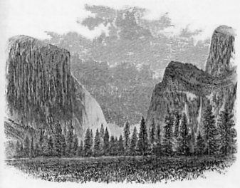
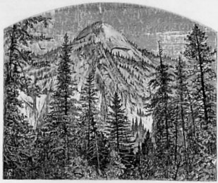
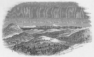
In descending the Mariposa trail, a steep climb of 2,973 feet down to the bottom of the Valley, the traveller has presented to him a succession of views of some of its dominant features, each successive point in the descent bringing him nearer, and, as it were, more face to face with these gigantic objects. Just before reaching the bottom, we have the view presented in the photograph No. 1. On the left is El Capitan, on the right the Bridal Veil Fall, coming down on the backside of the Cathedral Rocks, and in the centre the view of the Valley and beyond, into the cañon of the Tenaya Fork of the Merced, the point of the Half Dome, and, beyond it, Cloud’s Rest, being just visible over the intervening ridge of which the Sentinel Rock form a part. A general idea of the Valley can well be obtained from this point, and in one view; but, as we ride up between the walls, new objects are constantly becoming visible, which at the lower end were entirely concealed.
Of the cliffs around the Valley, El Capitan and the Half Dome are the most striking; the latter is the higher, but it would be difficult to say which conveys to the mind the most decided impression of grandeur and massiveness. El Capitan is an immense block of granite, projecting squarely out into the Valley, and presenting an almost vertical sharp edge, 3,300 feet in elevation (see photographs Nos. 3 and 4).
|
Fig. 1.
EL CAPITAN AND THE BRIDAL VEIL FALL. [From The Yosemite Guide-Book (1870)] |
On the other side of the Valley we have the Bridal Veil Fall, unquestionably one of the most beautiful objects in the Yosemite. It is formed by the creek of the same name, which rises a few miles east of Empire Camp, runs through the meadows at Westfall’s, and is finally precipitated over the cliffs, on the west side of Cathedral Rock, into the Yosemite, in one leap of 630 feet perpendicular. The water strikes here on a sloping pile of debris, down which it rushes in a series of cascades for a perpendicular distance of nearly 300 feet more, the total height of the edge of the fall above the meadow at its base being 900 feet. The effect of the fall, as everywhere seen from the Valley, is as if it were 900 feet in vertical height, its base being concealed by the trees which surround it (see photograph No. 2). The quantity of water in the Bridal Veil Fall varies greatly with the season. The photograph represents it as it is usually seen in June or July, when the amount of water is above the average. Probably the effect is finest when there is a little less water than is here represented; then the swaying from side to side, and the waving under the varying pressure of the wind, as it strikes the long column of water, is more marked. As seen from a distance, at such times, it seems to flutter like a white veil, producing an indescribably beautiful effect. The name Bridal Veil is poetical, but fairly appropriate. The Bridal Veil Creek heads low down in the Sierra, far below the region of eternal snow; hence, as summer advances, the supply of water is rapidly diminished and, by the middle or end of July, there is only a small streamlet trickling down the vertical face of the rock, over which it is precipitated in a bold curve when the quantity of water is larger. At the highest stage, the stream divides into a dozen streamlets at the base of the fall, several of which are only just fordable on horseback.
The Virgin’s Tears Creek, on the other side of the Valley, and directly opposite the Bridal Veil, makes also a fine fall, over a thousand feet high, included in a deep recess of the rocks near the lower corner of El Capitan. This is a beautiful fall as long as it lasts; but the stream which produces it dries up early in the season. In quantity of water, elevation and general effect, this fall, hardly spoken of at the Yosemite among so many grander ones, is far superior to the celebrated Staubbach of Switzerland.
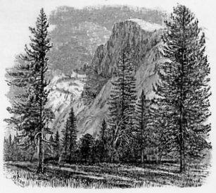
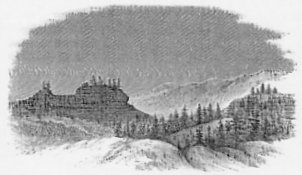
Proceeding up the Valley, we find on the same side as the Bridal Veil, and a little above it, the prominent and massively-sculptured pile of granite, to which the name of Cathedral Rock has been given. (See photographs Nos. 4, 5, 6.)
Fig. 2.
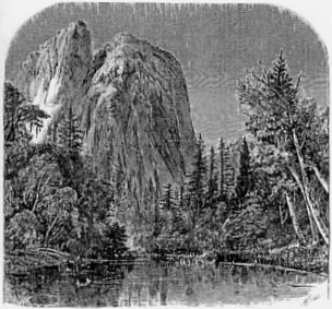
CATHEDRAL ROCK. [From The Yosemite Guide-Book (1870)] |
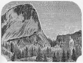
The next prominent object, in going up the Valley, is the triple group of rocks known as the Three Brothers (see photograph, No. 8) These rise in steps one behind the other, the highest being 3,830 feet above the Valley. From the summit of this, there is a superb view of the Valley and its surroundings. The photograph will render any description of the peculiar outline of these rocks unnecessary.
Fig. 3.
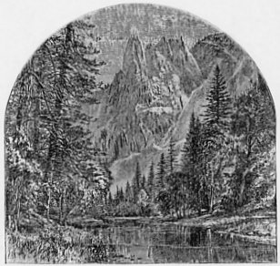
SENTINEL ROCK. [From The Yosemite Guide-Book (1870)] |
Nearly opposite the Three Brothers is a point of rocks projecting into the Valley, the termination of which is a slender mass of granite, having something the shape of an obelisk, and called, from its peculiar position, or from its resemblance to a gigantic watch-tower, the “Sentinel Rock.” Its form may be seen in the photograph, No. 9, which was taken from a point on the Merced somewhat farther down the Valley. The obelisk form of the Sentinel continues down for a thousand feet or more from its summit; below that, it is united with the wall of the Valley. The entire height is 3,043 feet above the river at its base. It is one of the grandest masses of rock in the Yosemite, and Mr. Watkins’s admirable photograph renders it with fine effect, giving also the character of the vegetation of mingled pines, oaks and poplars along the banks of the Merced.
PLATE. I.
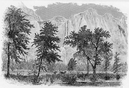
THE YOSEMITE FALL. [From The Yosemite Guide-Book (1870)] |
From near the foot of Sentinel Rock, looking directly across the Valley, we have before us what probably most persons will admit to be, if not the most stupendous, at least the most attractive feature of the Yosemite, namely “the Yosemite Fall” par excellence, that one of all the falls about the Valley which is best entitled to bear that name. The photograph, No. 10, was taken among a group of oaks near the Lower Hotel, a point of view directly in front, and from which the various parts seem most thoroughly to be blended into one whole of surpassing attractiveness. The finest photograph, however, is utterly inadequate to convey to the mind any satisfactory impression or realization of how many of the elements of grandeur and beauty are combined in this waterfall and its surrounding and accessories. The first and most impressive of these elements is, as in all other objects about the Yosemite, vertical height. In this it surpasses, it is believed, any waterfall in the world with anything like an equal body of water. And all the accessories of this fall are of a character worthy of, and commensurate with, its height, so that everything is added, which can be, to augment the impression which the descent of so large a mass of water from such a height could not fail, by itself, to produce.
The Yosemite Fall is formed by a creek of the same name, which heads on the west side of the Mount Hoffmann Group, about ten miles northeast of the Valley. Being fed by melting snows exclusively, and running through its whole course over almost bare granite rock, its volume varies greatly at different times and seasons, according to the amount of snow remaining unmelted, the temperature of the air and the clearness or cloudiness of the weather. In the spring, when the snow first begins to melt with rapidity, the volume of water is very great; as ordinarily seen by visitors in the most favorable portion of the season—say from May to July—the quantity will be about that represented in the photograph; still later, it shrinks down to a very much smaller volume. We estimated the size of the stream at the summit of the fall, at a medium stage of water, to be twenty feet in width and two feet in average depth. Mr. J. F. Houghton, measured the Yosemite Creek below the fall, June 17th, 1865, and found it to be thirty-seven feet wide and twenty five inches deep with the velocity of about a mile an hour, giving about half a million cubic feet as passing over the fall in an hour.* [*Our measurements gave about 220 cubic feet, as the amount of water passing over the fall in one second.] At the highest stage of water there is probably three times as much as this. The vertical height of the lip of the fall above the Valley is, in round numbers, 2,600 feet, our various measurements giving from 2,537 to 2,641, the discrepancies being due to the fact that a near approach to, or a precise definition of the place where the perpendicular portion of the fall commences is not possible. The lip or edge of the fall is a great rounded mass of granite, polished to the last degree, on which it was found to be a very hazardous matter to move. A difference of a hundred feet, in a fall of this height, would be entirely imperceptible to most eyes. The fall is not in one perpendicular sheet. There is first a vertical descent of 1,500 feet, when the water strikes on what seems to be a projecting ledge; but which, in reality, is a shelf or recess, almost a third of a mile back from the front of the lower portion of the cliff. From here the water finds its way, in a series of cascades, down a descent equal to 626 feet perpendicular, and then gives one final plunge of about 400 feet on to a low talus of rocks at the base of the precipice. The whole arrangement and succession of the different parts of the fall can be easily made out from the photograph, No. 11, which was taken from the Sentinel Dome, on the opposite side of the Valley, and at a considerable elevation above its edge.* [*The exact distance from the Sentinel Dome across in a straight line to the edge of the Upper Yosemite Fall is two and a half miles.] As the various portions of the fall are nearly in one vertical plane, the effect of the whole is nearly as grand, and perhaps even more picturesque, than it would be if the descent were made in one leap from the top of the cliff to the level of the Valley. Nor is the grandeur or beauty of the fall perceptibly diminished, by even a very considerable diminution of the quantity of water from its highest stage. One of the most striking features of the Yosemite Fall is, the vibration of the upper portion from one side to the other, under the varying pressure of the wind, which acts with immense force on so long a column. The descending mass of water is too great to allow of its being entirely broken up into spray; but it widens out very much towards the bottom, probably to as much as 300 feet, at high water, the space through which it moves being fully three times as wide. This vibratory motion of the Yosemite and Bridal Veil Falls is something peculiar, and not observed in any others so far as we know, and the effect of it is indescribably grand, especially under the magical illumination of the full moon.
The cliff a little east of the Yosemite Fall rises in a bold peak to the height of 3,030 feet above the Valley; it can be reached up Indian cañon, a little farther east, and from this point a magnificent view of the whole region can be obtained. The ascent to the summit of the fall and the return to the Valley can be made in one day, but only by good mountain climbers.
Following up the Valley for about two miles above the Yosemite Falls, we find that the main portion of it comes to an end and that it suddenly branches out in three distinct, but much narrower, cañons, as they would be called by Californians, each of which, however, has some new wonders to disclose. The Merced river keeps the middle one of these, and its course is here about the same that it was below, or nearly west; it holds this direction nearly up to the base of the Mount Lyell Group, where it heads, between the main crest of the Sierra the parallel subordinate or side range called by us the Merced or Obelisk Group. In the left hand, or northwesterly cañon, the Tenaya Fork of the Merced comes down, and in the right hand, or southwesterly one, the South Fork,* [*This is the South Fork of the Middle Fork, and not the real South Fork, which flows by Clark’s Ranch. To avoid confusion, it will be well to call it by the Indian name, Illilouette; one not yet much in use in the Valley.] or the Illilouette.
Fig. 4.
THE NORTH DOME. [From The Yosemite Guide-Book (1870)] |
At the angle where the Yosemite branches we have, on the north side, the rounded columnar mass of rock called the Washington Column, and immediately to the left of it the immense arched cavity called the Royal Arches, and over these is seen the dome-shaped mass called the North Dome, as shown in photograph No. 12. The opposite buttress of the Valley is represented in photograph No. 15, where the view is taken looking directly across the Main Merced, up the cañon of the South Fork.
Photograph No. 14 was taken near the entrance of the Tenaya Fork into the Main Merced and the instrument was directed obliquely across the Tenaya Valley, past the Washington Column, square against the face of the Half Dome, a position which will easily be understood by reference to the map of the Valley. No. 12 shows a portion of the east side of the Tenaya Cañon, still farther up than the Half Dome, and more of the Royal Arches than could be exhibited in No. 14.
The North Dome, rising to 3,568 feet above the Valley, is one of those rounded masses of granite which are not uncommon in the Sierra Nevada. These dome-shaped masses are somewhat characteristic of all granitic regions; but are nowhere developed on so grand a scale as in the Sierra. An examination of photograph No. 13 will show that the North Dome is made up of huge concentric plates of rock, overlapping each other, in such a way as to absolutely prevent an ascent on the side presented to the Valley; to the north, however, the Dome runs out in a long ridge, as represented on the map, and from that side there is not the slightest difficulty in getting to the summit.
PLATE. II.
THE CAÑON OF THE MERCED AND THE VERNAL FALL. [From The Yosemite Guide-Book (1870)] |
The concentric structure of the North Dome is well seen in the Royal Arches, which are in fact, a sort of appendage to its base. An examination of the photograph No. 12, will show at once how this peculiarity of structure pervades the whole mass of rock, and how these arches have been formed by the slipping down of immense plates of granite, the size of the cavity thus left being enormous, but not easily measured. The arches and the column, at the angle of the main Valley and the Tenaya Cañon, seem as if intended to form a base of adequate magnitude and grandeur for the support of the Dome which rests upon them.
Fig. 5.
THE HALF DOME. [From The Yosemite Guide-Book (1870)] |
The Half Dome, on the opposite side of the Tenaya Cañon, is the loftiest and most imposing mass of those considered as part of the Yosemite. It is not as high as Cloud’s Rest, but the latter seems rather to belong to the Sierra than to the Yosemite. The Half Dome is in sight, in the distance, as we descend the Mariposa trail; but is not visible in the lower part of the Valley itself; it is seen first when we come to the meadow opposite to Hutchings’s. The form of the Half Dome may be understood from photographs Nos. 14 and 19. In the one it is seen flatwise or in front, from below; and in the other nearly edgewise, from above. It is a crest of granite, rising to the height of 4,737 feet above the Valley, perfectly inaccessible, being probably the only one of all the prominent points about the Yosemite which never has been, and never will be, trodden by human foot. The summit of the Half Dome runs in a northeast and southwest direction, parallel with the cañon; it rises on the southwest side with a grand, regular dome-like form, but falls off rapidly in a series of steps as it descends to the northeast. At right-angles with this, or cross-wise of the mass, the section is very peculiar. On the side fronting Tenaya Cañon, it is absolutely vertical for 2,000 feet or more down from the summit, and then falls off with a very steep slope, of probably 60 or 70 degrees, to the bottom of the cañon. This slope, however, is not, as one would suppose, a talus of fragments fallen from above; it is a mass of granite rock, part and parcel of the solid structure of the Dome; the real debris pile at the bottom is absolutely insignificant in dimensions compared with the Dome itself. On the opposite face the Half Dome is not absolutely vertical; it has a rounded form at the top and grows more and more steep at the bottom. In photograph No. 19, we see something of this, although the view is not taken quite edgewise of the Dome. The whole appearance of the mass is that of an originally dome-shaped elevation, with an exceedingly steep curve, of which the western half has been split off and become engulfed. This geological theory of its formation appears to have forced itself upon those who gave it the name “Half Dome,” which is one that seems to suggest itself, at the first sight of this truly marvelous crest of rock. From all the upper part of the Valley and from all the heights about it, the Half Dome presents itself as an object of the most imposing grandeur. It has not the massiveness of El Capitan, but is more astonishing, and probably there are few visitors to the Valley who would not concede to it the first place among all the wonders of the region. Even the most casual observer must recognize in it a new revelation of mountain grandeur. Those who have not seen it could never comprehend its extraordinary form and proportions, not even with the aid of photographs. It is entirely unique in the Sierra Nevada; and, so far as we know, in the world. The only possible rival would be the Matterhorn. Each is unique in its way; but the forms of the two are so different, that they will hardly bear comparison.
Farther up the cañon of the Tenaya, is a beautiful little lake called “Mirror Lake,” an expansion of the Tenaya Fork. It is frequently visited, and best early in the morning, for the purpose of getting the reflection from its unruffled surface of a noble overhanging mass of rock, to which the name of Mount Watkins has been given, as a compliment to the photographer who has done so much to attract attention to this region.
Still farther up the Tenaya Fork, on the right-hand side, is “Cloud’s Rest,” the somewhat fanciful designation of a long, bare, steep and extremely elevated granite ridge, which connects the Valley with the High Sierra. This point is one of the few which has not been measured by the Geological Survey; it is perhaps a thousand feet higher than the Half Dome, or nearly 10,000 feet above the sea-level. Its bare steep slope, uniform from summit to base, will be recognized in photograph No. 19, just behind the Half Dome.
Following up the Tenaya Fork cañon we find the creek coming down in a series of cascades and waterfalls through an almost impassable gorge; but through which access may be had, by good climbers, to the trail from Big Oak Flat to Mono Lake. It is, however, not passable for animals.
We return now to the cañon of the Main Merced river, which also has its own peculiar wonders to disclose. Leaving the Yosemite Valley proper, at the angle, spoken of before, where the three cañons unite, we follow up the Merced, soon crossing the Illilouette, which carries perhaps a third or a quarter as much water as the main river. Rising rapidly, on a trail which runs along near the river, over the talus of great angular masses fallen from above, we ride a little less than a mile, and nearly to the base of the first of the two great falls made by the Merced in coming down from the level of the plateau above into the Yosemite Valley. In doing this, the river descends, in two miles, over 2,000 feet, making, besides innumerable cascades, two grand falls, which are among the greater attractions of the Yosemite, not only on account of their height and the large body of water in the river during most of the season, but also on account of the stupendous scenery in the midst of which they are placed.
The first fall reached in ascending the cañon is the Vernal, a perpendicular sheet of water with a descent varying greatly with the season. Our measurements give all the way from 315 to 475 feet for the vertical height of the fall, between the months of June and October. The reason of these discrepancies seems to lie in the fact that the rock near the bottom is steeply inclined, so that a precise definition of the place where the perpendicular part ceases is very difficult amid the blinding spray and foam. The force of the fall is greater, as the body of water increases, and of course it is thrown farthest forward when the mass of water is greatest. Probably it is near the truth to call the height of the fall, at the average stage of water in June or July, 400 feet. The rock behind this fall is a perfect squarely-cut mass of granite extending across the cañon, and it is wonderful to see, at low water, how little the eroding effect of the river has had to do with the formation of the cañon and fall. It would seem as if causes now in action had little or nothing to do with the formation of this step in the descent of the Merced to the Valley below. Photograph No. 16 shows the Vernal Fall at a medium stage of water; directly behind it, the summit of the “Cap of Liberty,” or Mount Broderick, as it has also been called, begins to be visible.
The path up the side of the cañon near the fall winds around and along a steeply sloping mountain-side, always wet with the spray, and consequently rather slippery in places. Ladies, however, find no great difficulty in passing, with the aid of friendly arms, and protected by stout boots and india-rubber clothing brought from the hotel. The perpendicular part of the ascent is surmounted by the aid of ladders, which should be replaced by a substantial and well protected stair-case. At the summit of the fall the view down the cañon, as well as in the opposite direction, is extremely fine. A remarkable parapet of granite runs along the edge of the Vernal Fall for some distance, just breast-high, and looking as if made on purpose to afford the visitor a secure position from which to enjoy the scene.
Fig. 6.
THE CAP OF LIBERTY AND THE NEVADA FALL. [From The Yosemite Guide-Book (1870)] |
From the Vernal Fall up stream, for the distance of about a mile, the river may be followed, and it presents a succession of cascades and rapids of great beauty. As we approach the Nevada Fall, the last great one of the Merced, we have at every step something new and impressive. Photograph No. 17 was taken a little above the summit of the Vernal Fall; it represents the Nevada Fall, as seen at the distance of something less than a mile, and on the left as much of the mass of the Cap of Liberty as could be included in the picture. This latter is a grand mass of rock, isolated and nearly perpendicular on all sides, rising perhaps 2,000 feet above its base, and little inferior to the Half Dome in grandeur. It has been climbed, and has on its summit, according to Mr. Hutchings’s statement, a juniper tree of enormous diameter.
The Nevada Fall (see photograph No. 18, taken from near its base), is, in every respect, one of the grandest waterfalls in the world, whether we consider its vertical height, the purity and volume of the river which forms it, or the stupendous scenery by which it is environed. The fall is not quite perpendicular, as there is near the summit a ledge or rock which receives a portion of the water and throws it off with a peculiar twist, adding considerably to the general picturesque effect (see photograph) . A determination of the height of the fall was not easy, on account of the blinding spray at the bottom, and the uncertainty of the exact spot where the water strikes. Indeed this seems to vary in the Nevada as well, although not as much, as in the Vernal Fall. Our measurements made the Nevada from 591 to 639 feet, at different times and seasons. To call the Vernal 400 and the Nevada 600 feet, in round numbers, will be near enough to the truth. The descent of the river in the rapids between the two falls is nearly 300 feet.
In the cañon of the South Fork, or Illilouette, there is a fine fall, estimated at 600 feet high. It is seen from a point on the trail from the Hotel to Mirror Lake, although but rarely visited by travellers, the cañon being rough and difficult to climb. A trail should be made up this cañon, to give access to the fall, and to the superb views to be had of the back of the Half Dome[,] the Vernal Fall, and other interesting points.
Having thus run rapidly through the list of objects in the Valley best known and most likely to be visited, we will give a more systematic and general account of the Yosemite—its botany, topography and geology; this will enable us to bring forward some interesting considerations which could not so well be introduced in geographical order in a detailed enumeration of the points of interest. The Yosemite Valley proper, that is to say what would be considered by the visitor as naturally included under that designation, may be described as consisting of three parts, the bottom of the Valley, or the actual Valley, the talus, or debris-slope, and the walls, or the vertical or nearly vertical solid rock. Each of these parts will be noticed in order. First, the bottom, or Valley proper. This is a nearly level area, having a gentle slope, with the river, to the southwest, of only 35 feet between the junctions of the Tenaya Fork and the Bridal Veil Creek with the main river, four miles and a half in a straight line. The width of the space between the debris-slopes is very variable. In the upper half of the Valley it averages somewhat less than half a mile. A little below the Three Brothers it closes to an eighth of a mile in width; and between El Capitan and Cathedral Rock the river “cañons,” to use a California phrase, meaning that the Valley is narrowed down, so that there is only just room for the river to pass. Below this, it opens out again, and forms two charming little patches of meadow, of about 20 acres each in extent. There are, altogether, 1,141 acres of land in the Valley proper, of which 745 are meadow, and the remainder a sandy soil, a little more elevated, partly covered with a sparse growth of forest trees and partly with pertinacious ferns. The elevation of the bottom of the Valley above the sea-level is, in round numbers, 4,000 feet. The mean of our observations, in June, was 4,046 feet; those taken by Miss Sproat, in October, gave, as calculated by Col. R. S. Williamson, 3,935 feet. The mean of these results is 3,990 feet, and that is probably not far from the truth. Through the Valley flows the Merced river, about 70 feet in width, making many sharp and curiously angular bends, touching the talus first on one side and then on the other.
Along the banks of the river and over the adjacent rather swampy meadows, we find a somewhat varied vegetation, according to the locality, the narrow portions of the Valley differing considerably from the broader ones. In the former, near the falls, there is a dense growth of alder (Alnus viridis), which sometimes forms quite a large tree, with ash-colored bark; associated with this are small trees of Rhamnus Menziesii, remarkable for its large and sombre leaves. A few willows, the Douglas spruce (Abies Douglasii), and, in the upper part of the Valley, an occasional sugar pine, are also found in this position. Where the Valley widens out, and the river banks become lower, so that sloughs and swamps are formed, the Balm of Gilead poplar (Populus balsamifera) comes in; this is a common tree in the Valley, and is usually mistaken for the cottonwood; with this occur large willows and abundance of the Douglas spruce, and also the Azalea occidentalis, whose superb white and fragrant flowers form one of the charms of the Valley. Hellenium grandiflorum, Nutt., with its numerous yellow flowers, is a showy and conspicuous plant on and near the river banks. The meadows are swampy, with a deep peaty soil; their vegetation consists chiefly of carices or sedges and a few coarse grasses (Calamagrostis Canadensis, Beauv., Phragmites communis, L., Glyceria nervata, Trin). In a small pond on Mr. Hutchings’s farm, the yellow pond-lily (Nuphar advena, Ait.) occurs. At the upper part of the side cañons and near the falls, the Vernal especially, the cryptogamic vegetation is most abundantly developed. Where the rocks are kept moistened by the spray numerous mosses thrive; and even on the hill slopes, as far as the moisture reaches, the peat moss (Sphagnum) grows. The shelving rocks in such positions are decorated with several species of most graceful ferns. About the Vernal Fall, the following species occur, all of rare beauty; Adiantum pedatum, Kaulf., Pelloea densa, Hook., P. Bridgesii, Hook., P. mucronata, Eat., Cheilanthes gracillima, Eat.[,] Polypodum Californicum, Kaulf., Aspidium argutum, Kaulf., and Cystopteris fragilis, Bernh.
The sandy region of the Valley proper forms a connecting strip along the edge of the rocky talus, on both sides of the river. It is quite irregular in width; but it makes up the largest portion of the Valley above Indian Cañon. It has evidently been formed by the disintegration and washing down of the finer portions of the debris from the walls. The soil is a coarse, loose, deep sand, containing but little vegetable matter, and becoming finer, more compact and more fertile as it approaches the river. This is peculiarly the arboriferous belt of the Valley, and various portions of its area exhibit different characters of vegetation to correspond with the differences of soil. On the drier and looser portions, the pitch (or yellow) pine (P. ponderosa) and the bastard cedar (Libocedrus decurrens) are the most abundant and characteristic trees; both these species occur of considerable size and of fine proportions, the pines being usually from 125 to 150 feet high. Below the Bridal Veil Fall, near the debris, the fir (Picea grandis), a noble tree, comes in; near the swampy land, the black oak (Q. Sonomensis) is abundant. The sandy region also bears a great number and variety of shrubs and undergrowth; among these are: the Cornus Nuttallii, with its showy white flowers, three inches in diameter; Rubus Nutkanus, the most beautiful of the raspberries, and found from Lake Superior west; also the characteristic California shrub, manzanita (Arctostaphylos glauca). Among the lower shrubs are: the wild rose, (Rosa blanda); Pentstemon laetus, with its beautiful blue flowers; Hosackia grandiflora, also with brilliant flowers; also, in places, the Frangula Californica, forming dense thickets; the same is true of the low willow. The common brake (Pteris aquilina) is very abundant and sometimes very large. The curious Spraguea umbellata, one of the most characteristic flowers of the Valley, is also abundant in the sandy region. In places, especially below the Bridal Veil Fall, Comandra umbellata, Silene compacta and Chaenactis achillaefolia cover the ground. An examination of the different photographs will show how the vegetation is distributed in the Valley, and the most characteristic trees will easily be recognized.
The meadows and sandy portions, described above as constituting the bottom of the Valley, contain all the land in the Yosemite which can be utilized for any purpose, such as building or cultivation. The talus or debris, the second great division, forms steeply sloping masses of rocky fragments piled along the base of the cliffs, on both sides and from one end of the Valley to the other. Only in a very few places do the nearly vertical walls come squarely down to the level of the Valley, without any intervening talus. These places are easily recognized upon the map. The talus, however, is everywhere of insignificant height compared with the cliffs themselves, this being, as before remarked, one of the characteristic features of the Valley. The debris lies chiefly in the receding or re-entering angles, and in the cañons or gorges down which the smaller streams flow into the Valley. It is least conspicuous around some of the more prominent and elevated projecting points, as the Three Brothers, El Capitan and the Cathedral Rock. Singularly enough, there is also very little debris at the foot of the Yosemite Fall; while, on the opposite side of the Valley, the talus is exceptionally wide. On examining the photographs, it will be noticed at once how little the talus has to do with producing the general effect of the Yosemite; in most of them it can hardly be recognized as existing at all.
The most characteristic tree of the debris piles is, perhaps, the mountain live-oak (Q. chrysolepis, Liebm.), which is associated, in the higher portions, with the common shrubby evergreen oak of the higher Sierras, perhaps the Q. vaccinifolia, of Kellogg. In the vicinity of the points where small streams come over the precipices, we find the Oregon maple (Acer macrophyllum, Pursh), with its large and deeply-cut leaves, and, in the higher portions of the debris, another maple (Acer glabrum, Torr.), a shrub, 10 or 15 feet high, whose delicate branches, long peduncled leaves and clusters of reddish seed make it an object conspicuous for its beauty. Near the base of the debris, where the streams of the smaller waterfalls emerge, the California laurel (Tetranthera Californica), occurs as a small tree, with smooth brilliant evergreen foliage and aromatic odor. Among the smaller plants, we have several beautiful species of Pentstemon; one with brilliant scarlet flowers (P. Menziesii, Hook.) is very conspicuous. Bahia confertiflora, a low shrub, with densely clustered yellow flowers, is also abundant. A number of species of grasses, of great interest to the botanists, also occur in this position; and in the crevices of the rocks the beautiful little fern (Cheilanthus gracillima), with several others equally graceful, occurs.
The slope along the descent by which the Mariposa trail winds into the Valley offers, also, an interesting and peculiar grouping of species. Oaks, pines and firs make up the forest, and with these is a profusion of flowering shrubs, some of which are very showy. Among these are: the Ceanothus integerrimus H. & A., with its dense clusters of white or pale-blue and fragrant flowers, often called the beauty of the Sierra, the C. divaricatus, Nutt., with fragrant blue flowers; Philadelphus Californicus, with large white flowers; an occasional “poison oak” (Rhus diversiloba, T. & G.); also the “snow plant” or “ice plant” (Sarcodes sanguinea, Torr.), the whole of which is of a brilliant red, like a tongue of flame issuing from the ground; and, especially, the great white Lily of the Sierra (Lilium Umquaensis?), perhaps the most superb and deliciously fragrant flower of California.
In noticing the photographic illustrations, the salient and most striking points in the walls of the Yosemite have been mentioned. The whole Valley, however, is surrounded by this wall, and the objects particularly noticed were only such portions of it as attract general and immediate attention, owing to some peculiarity of form or position. Every portion of the Yosemite wall is sublime; and where there is so much to be seen, and where every object can be seen from so many different points of view, there is hardly any limit to the combinations of the different elements of landscape beauty, which can be obtained by change of position and change of illumination. The color of the granite of the walls is a light grey brilliantly white, generally, when the sun’s light is reflected from it. It is, in places, diversified with veins of a brighter or deeper hue; but these patches of color are not conspicuous enough to produce much effect. More character is given by the vertical parallel lines of darker color—grey, brown and black with which portions of the walls are striped. These are the result of the flowing down of water, in the line of most direct descent, over the face of the cliffs, carrying organic matter in solution or suspension. These stains are very conspicuous, and not at all ungraceful, on the Royal Arches, as well as on El Capitan and other vertical cliffs. The general effect of the cliffs, as to color, is dazzling in the sun-light; but it is the brilliancy of cold colors, not of warm ones, and the various oil paintings of the Yosemite, representing a rich golden haze as pervading and giving its hue to everything in the Valley, are simply and entirely untrue to nature. The beauty of color comes rather from the intensity of the contrast of the grey rock with the brilliant vegetation of the Valley bottom, and, in a less degree, with that of the cañons and the edge of the cliffs.
Although there is no exit from the Yosemite for a mounted traveller, except by one of the two trails winding up the steep slope at the lower end of the Valley, there are several places where a footman can find his way out without any difficulty, except that naturally resulting from a climb up a steep slope of angular rocks, equal in vertical rise to 3,000 feet and more. Tourists have occasionally climbed up Indian Cañon to the head of the Yosemite Fall (see map), and also up the gorge by the side of Sentinel Rock, to get to its summit and to the Sentinel Dome. There are places where one could climb up, apparently, near the Cathedral, a little below El Capitan and between El Capitan and the Three Brothers; but we are not aware that they have ever been tried. Persons who are not accustomed to climbing, and especially ladies, are strongly advised to ride out of the Valley on the regular trails, where they wish to make excursions on the outside, rather than risk getting over-fatigued in performing acrobatic feats, which are not at all necessary to enable one to see and enjoy the whole region. More than one person, however, has climbed, stocking-footed in some particularly ticklish places, up the cliff on the left hand side of the Yosemite Fall, along the ledges, where there is room, if not for a foot-hold, at least for a toe-hold. We have never heard that any serious accident has happened to visitors to the Yosemite, but too much caution cannot be used, by ladies especially, in regard to over-fatiguing themselves.
Some general statements as to the waterfalls of the Yosemite, in addition to what has already been said on this subject, may here be introduced. The principal falls about the Valley have already been described; but there are several others not yet mentioned which are worthy of notice. It is only early in the season, while the snow on the summits immediately adjacent to the Valley is melting that the “grandes eaux” of this national park can be said to be in play. Indeed at such times, and especially after the few first warm days in the spring, there are large numbers of small streams discharging themselves over the cliffs, and each of course producing a waterfall proportionate in picturesque effect to the amount of water it furnishes. Of these minor falls, there are several which continue for a considerable time; others are quite short-lived. The Virgin’s Tears Creek is one of the finest of the former; in 1867, it was quite a fine sight in June. There is another, nearly opposite, on a stream called Meadow Brook, which is well seen by those coming into the Valley on the Mariposa trail early in the season. A stream, heading at Ostrander’s Rocks comes down near Sentinel Rock, in a kind of “Buttermilk Fall,” or series of step-like cascades, until all the snow at its head has disappeared. The fall over the Royal Arches also keeps itself alive for some time, with quite a body of water coming down from the North Dome, and on the opposite side the Sentinel Dome also furnishes its quota towards keeping up the high display of the Yosemite. There are as many reasons, then, as there are waterfalls in the Valley, why the traveller should visit the Yosemite early in the season. It is true that some visitors, who have arrived too late to see the falls in their grandeur, have voted them, if not “humbugs,” at least non-essential to the glory of the Yosemite. They have been so much impressed with the mighty cliffs and domes, that they have not conceived it possible that such sublimity could be heightened by the introduction of any additional features. It is true that the Valley has about it, aside from its waterfalls, that which will amply repay the traveller for the time and labor required for his visit; but it is not true that such natural objects as the Yosemite, the Vernal or Nevada Falls, seen with all their glorious surroundings, do not immeasurably enhance the attractions of the Valley. The traveller should endeavor, if possible, to visit the region just as the last snow is disappearing from the plateau; and, as soon as the trail is made on a lower level, as suggested above, he will be able to do so with ease and comfort at a considerably earlier period than now. May, June or July are the most favorable months; and even April, in some years, would not be too early. Of the principal falls in the Valley, only the Vernal and Nevada continue in existence through the season. The Yosemite and the Bridal Veil shrink almost to nothing by August or September. This is the result of the peculiar climate of California, by which rains are, even in the mountains, almost entirely dispensed with during the six summer months, so that the streams have to be fed exclusively from melting snow. As every rule has its exception, it sometimes happens here, that heavy thunder showers around the Valley raise the streams suddenly in mid-summer to the highest point of their winter flow. This occurred in 1867, when a violent thunder-storm at the head of the Merced, in June, raised the South Fork at Clark’s ranch and the Yosemite Creek several feet, within half an hour. This rain-fall was limited to a quite small area; but a very large amount of water must have fallen in a short space of time. It was probably of the nature of one of those violent deluges, which not unfrequently occur in California, and which are generally known as “cloud-bursts.”
Some comparison of the principal falls in the Yosemite with the most celebrated ones in other parts of the world will be of interest to the tourist, as enabling him to form an opinion as to their relative attractiveness. There are several circumstances to be taken into consideration, however, in a comparison of waterfalls. Absolute height and quantity of water are undoubtedly the two important elements; but all the accessories have a share in producing the general effect. The fall is the picture; but the value of it is wonderfully heightened or diminished, according to the more or less picturesque character of the frame in which it is set. Exactly in what ratio the effect of different waterfalls varies with the mutual variability of their height and volume, it is not easy to say. There are those on whom Niagara, with its 160 feet of vertical fall and its immense mass of water, would produce a greater effect than the Yosemite with its ten times greater height and its much more than ten times diminished volume. Others, again, would consider the higher fall as much the more attractive, in spite of its comparatively small body of water. Niagara and the Zambesi are typical falls for volume; but probably no one has seen both of these, so as to be able to institute a valuable comparison between them.
The falls visited by tourists, in Europe, are very numerous; but they all belong to the type of those which impress by their height and not by their volume, resembling in this respect the Yosemite Fall. The most celebrated are those of Norway and Switzerland; but the highest of all is that of Gavarnie, in the Pyrenees, in which the vertical descent is 1,266 feet. In this fall the quantity of water is only just enough to form a dozen thin streams, trickling down the face of the rock, with one, a little larger than the others, which swings off as a white cord, twice broken by projecting ledges, and entirely dissipated in spray, before it reaches the bottom. It is plain enough, then, that the fall of Gavarnie will not compare with that of the Yosemite either in volume or height. The fall of the Staubbach, in Switzerland, is about the height of the Bridal Veil; but the quantity of water is extremely small, so that the effect is insignificant, compared even with that of the Virgin’s Tears. The fall of the Aar, at Handek, makes a fine show; but is not, by any means, as imposing as the Vernal Fall, being inferior to it in elevation and in volume, and of course much behind the Nevada in both respects. The Vöring Foss, in Norway, is generally admitted to be the finest waterfall in Europe; its volume is about that of the Aar, at Handek, and its height is estimated at 850 feet. It has never been measured, for it falls into an inaccessible chasm, which is only just as wide as the stream itself. As it can only be viewed from above, much of the impressiveness of the fall is lost. Mr. Brace, the author of the “Norse-Folk,” who is probably the only person who has seen both the Yosemite Valley and the Vöring Foss, considers the Norwegian falls to be far inferior to those of California. Asia and South America seem poorly provided with waterfalls; at least there are none described which can be mentioned in comparison with those of Europe and North America; and it is likely that, if any of surpassing grandeur existed in those countries, they would have become known before this time. [Footnote in 1871 edition: Since this was written a very fine fall, called the Kaieteur, is said to have been discovered in British Guiana.] We are disposed to believe that a majority of cultivated lovers of natural scenery would admit the Yosemite Fall to surpass any in the world, as presenting the most perfect combinations of all the elements of the picturesque. Certainly, taking the whole region of the Yosemite together, with its five great falls, the lowest 400 feet and the highest 2,600, it must be allowed that, in this particular kind of scenery, it is a locality without a rival in the world.
Although the Valley is, at present, almost inaccessible in the winter, and, indeed, entirely so to those who are not up in travelling on snow-shoes, it is not unlikely that the time will soon come when a visit to it at that season will be considered as the regular thing for tourists, and when proper facilities for getting there will be provided. The views, at the time when the snow is still lying deep on the surrounding plateau, and thundering down in frequent avalanches from the domes and over the walls of the Valley; or, a little later, when the streams are filled to repletion and pour themselves over the cliffs in literally unnumbered cascades; when the Merced becomes a mad torrent and hurries down its 2,000 feet of vertical descent in one wild mass of spray-enveloped waters all this is, as described by those who have seen it, of surpassing grandeur. The accumulation of ice at the base of the upper part of the Yosemite Fall is also spoken of as a most impressive feature in the winter view. The frozen spray forms a vast conical mass, rising sometimes to the height of a hundred feet or more, from which the falling water, rebounding, is shot off in graceful curves, forming an immense bouquet, each drop of which sparkles like a diamond in the sun.
All will recognize in the Yosemite a peculiar and unique type of scenery. Cliffs absolutely vertical, like the upper portions of the Half Dome and El Capitan, and of such immense heights as these, are, so far as we know, to be seen nowhere else. The dome form of mountains is exhibited on a grand scale in other parts of the Sierra Nevada; but there is no Half Dome, even among the stupendous precipices at the head of the King’s River. No one can avoid asking, what is the origin of this peculiar type of scenery? How has this unique valley been formed, and what are the geological causes which have produced these wonderful cliffs and all the other features which combine to make this locality so remarkable? These questions we will endeavor to answer, as well as our ability to pry into what went on in the deep-seated regions of the earth, in former geological ages, will permit.
Most of the great cañons and valleys of the Sierra Nevada have resulted from aqueous denudation, and in no part of the world has this kind of work been done on a larger scale. The long-continued action of tremendous torrents of water, rushing with impetuous velocity down the slopes of the mountains, has excavated those immense gorges by which the chain of the Sierra Nevada is furrowed, on its western slope, to the depth of thousands of feet. This erosion, great as it is, has been done within a comparatively recent period, geologically speaking, as is conclusively demonstrated in numerous localities. At the Abbey’s Ferry crossing of the Stanislaus, for instance, a portion of the mass of Table Mountain is seen on each side of the river, in such a position as to demonstrate, that the current of the lava which forms the summit of this mountain once flowed continuously across what is now a cañon over 2,000 feet deep, showing that the erosion of that immense gorge has all been effected since the lava flowed down from the higher portion of the Sierra. This event took place, as we know from the fossil bones and plants embedded under the volcanic mass, at a very recent geological period, or in the latter part of the Tertiary epoch. Some even claim that it happened since the appearance of man on the earth; but this, although not impossible, remains yet to be proved.
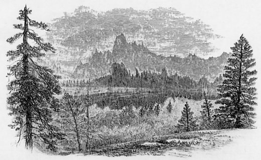
Fig. 7.
DISTANT VIEW OF TABLE MOUNTAIN. [From The Yosemite Guide-Book (1870)] |
Fig. 8.
FORT HILL,—NEAR RAILROAD FLAT. [From The Yosemite Guide-Book (1870)] |
PLATE. III.
VOLCANIC RIDGES NEAR SILVER MOUNTAIN. [From The Yosemite Guide-Book (1870)] |
[From The Yosemite Guide-Book (1870): Figures 7 and 8 and Plate III show the varying forms and picturesque character of some of these outliers of volcanic materials. Fig. 7 represents Table Mountain in Tuolumne County, as seen from a point distant about twelve miles in a south-easterly direction. The long straight line of its upper edge, destitute of vegetation and dark colored, will easily be recognized. Fig. 8 represents a picturesque outlier of volcanic materials near Railroad Flat in Calaveras County, which is quite surrounded by ridges of this character, rising 600 to 800 feet above the general level of the region, and indicating clearly the great erosion which has taken place since a recent geological period. ]
The eroded cañons of the Sierra, however, whose formation is due to the action of water, never have vertical walls, nor do their sides present the peculiar angular forms which are seen in the Yosemite, as for instance in El Capitan, where two perpendicular surfaces of smooth granite more than 3,000 feet high, meet each other at right angles. It is sufficient to look for a moment at the vertical faces of El Capitan and the Bridal Veil rock, turned down the Valley, or away from the direction in which the eroding forces must have acted, to be able to say that aqueous erosion could not have been the agent employed to do any such work. The squarely cut re-entering angles, like those below El Capitan, and between Cathedral Rock and the Sentinel, or in the Illilouette cañon, were never produced by ordinary erosion.
Much less could any such cause be called in to account for the peculiar formation of the Half Dome, the vertical portion of which is all above the ordinary level of the walls of the Valley, rising 2,000 feet, in sublime isolation, above any point which could have been reached by denuding agencies, even supposing the current of water to have filled the whole Valley. Much less can it be supposed that the peculiar form of the Yosemite is due to the erosive action of ice. A more absurd theory was never advanced, than that by which it was sought to ascribe to glaciers the sawing out of these vertical walls and the rounding of the domes. Nothing more unlike the real work of ice, as exhibited in the Alps, could be found. Besides, there is no reason to suppose, or at least no proof, that glaciers have ever occupied the Valley or any portion of it, as will be explained in the next chapter, so that this theory, based on entire ignorance of the whole subject, may be dropped without wasting any more time upon it.
The theory of erosion not being admissible to account for the formation of the Yosemite Valley, we have to fall back on some one of those movements of the earth’s crust to which the primal forms of mountain valleys are due. The forces which have acted to produce valleys are complex in their nature, and it is not easy to classify the forms which have resulted from them in a satisfactory manner. The two principal types of valleys, however, are those produced by rents or fissures in the crust, and those resulting from flexures or foldings of the strata. The former are usually transverse to the mountain chain in which they occur; the latter are more frequently parallel to them, and parallel to the general strike of the strata of which the mountains are made up. Valleys which have originated in cross fractures are usually very narrow defiles, enclosed within steep walls of rocks, the steepness of the walls increasing with the hardness of the rock. It would be difficult to point to a good example of this kind of valley in California; the famous defile of the Via Mala in Switzerland is one of the best which could be cited. Valleys formed by foldings of the strata are very common in many mountain chains, especially in those typical ones, the Jura and the Appalachians. Many of the valleys of the Coast Ranges are of this order. A valley formed in either one of the ways suggested above may be modified afterwards by forces pertaining to either of the others; thus a valley originating in a transverse fissure may afterwards become much modified by an erosive agency, or a longitudinal flexure valley may have one of its sides raised up or let down by a “fault” or line of fissure running through or across it.
If we examine the Yosemite to see if traces of an origin in either of the above ways can be detected there, we obtain a negative answer. The Valley is too wide to have been formed by a fissure; it is about as wide as it is deep, and, if it had been originally a simple crack, the walls must have been moved bodily away from each other, carrying the whole chain of the Sierra with them, to one side or the other, or both, for the distance of half a mile. Besides, when a cliff has been thus formed, there will be no difficulty in recognizing the fact, from the correspondence of the outlines of the two sides; just as, when we break a stone in two, the pieces must necessarily admit of being fitted together again. No correspondence of the two sides of the Yosemite can be detected, nor will the most ingenious contriving, or lateral moving, suffice to bring them into anything like adaptation to each other. A square recess on one side is met on the other, not by a corresponding projection, but by a plain wall or even another cavity. These facts are sufficient to make the adoption of the theory of a rent or fissure impossible. There is much the same difficulty in conceiving of the formation of the Valley by any flexure or folding process. The forms and outlines of the masses of rock limiting it are too angular and have too little development in any one direction; they are cut off squarely at the upper end, where the ascent to the general level of the country is by gigantic steps and not by a gradual rise. The direction of the Valley, too, is transverse to the general line of elevation of the mountains and not parallel with it, as it should be, roughly at least, were it the result of folding or upheaval.
In short, we are are led irresistibly to the adoption of a theory of the origin of the Yosemite in a way which has hardly yet been recognized as one of those in which valleys may be formed, probably for the reason, that there are so few cases in which such an event can be absolutely proved to have occurred. We conceive that, during the process of upheaval of the Sierra or, possibly, at some time after that had taken place, there was at the Yosemite a subsidence of a limited area, marked by lines of “fault” or fissures crossing each other somewhat nearly at right-angles. In other and more simple language, the bottom of the Valley sank down to an unknown depth, owing to its support being withdrawn from underneath, during some of those convulsive movements which must have attended the upheaval of so extensive and elevated a chain, no matter how slow we may imagine the process to have been. Subsidence, over extensive areas, of portions of the earth’s crust, is not at all a new idea in geology, and there is nothing in this peculiar application of it which need excite surprise. It is the great amount of vertical displacement for the small area implicated which makes this a peculiar case; but it would not be easy to give any good reason why such an exceptional result should not be brought about, amid the complicated play of forces which the elevation of a great mountain chain must set in motion.
By the adoption of the subsidence theory for the formation of the Yosemite, we are able to get over one difficulty, which appears insurmountable with any other. This is, the very small amount of debris at the base of the cliffs and even, at a few points, its entire absence, as previously noticed in our description of the Valley. We see that fragments of rock are loosened by rain, frost, gravity and other natural causes, along the walls, and probably not a winter elapses that some great mass of detritus does not come thundering down from above, adding, as it is easy to see from actual inspection of those slides which have occurred within the past few years, no inconsiderable amount to the talus. Several of these great rock-avalanches have taken place since the Valley was inhabited. One which fell near Cathedral Rock is said to have shaken the Valley like an earthquake. This abrasion of the edges of the Valley has unquestionably been going on during a vast period of time; what has become of the detrital material? Some masses of granite now lying in the Valley—one in particular near the base of the Yosemite Fall—are as large as houses. Such masses as these could never have been removed from the Valley by currents of water; in fact there is no evidence that any considerable amount of rock has been, for the cañon of the Merced, below the Yosemite is nearly free from detritus all the way down to the plain. The falling masses have not been carried out by a glacier, for there are no remains of the moraines below the Valley, which such an operation could not fail to have formed.
It appears to us that there is no way of disposing of the vast mass of detritus, which must have fallen from the walls of the Yosemite since the formation of the Valley, except by assuming that it has gone down to fill the abyss, which was opened by the subsidence which our theory supposes to have taken place. What the depth of chasm may have been, we have no data for computing; but that it must have been very great is proved by the fact that it has been able to receive the accumulations of so long a period of time. The cavity was, undoubtedly, occupied by water, forming a lake of unsurpassed beauty and grandeur, until quite a recent epoch. The gradual desiccation of the whole country, the disappearance of the glaciers and the filling up of the abyss to nearly a level with the present outlet, where the Valley passes into a cañon of the usual form, have converted the lake into a valley with a river meandering through it. The process of filling up still continues, and the [t]alus will accumulate perceptibly fast, although a long time must elapse before the general appearance of the Valley will be much altered by this cause, so stupendous is the vertical height of its walls, and so slow their crumbling away, at least as compared with the historic duration of time.
Lake Tahoe and the valley which it partly occupies we conceive also to be, like the Yosemite, the result of local subsidence. It has evidently not been produced by erosion; its depth below the mountains on each side, amounting to as much as 3,000 feet, forbids this idea, as do also its limited area and its parallelism with the axis of the chain. The Lake is still very deep, over 1,000 feet; but how deep it was originally and how much detritus has been carried into it, we have no data for even crudely estimating.
Next: Chapter 4: The High Sierra • Index • Previous: Chapter 2: General
| Online Library: | Title | Author | California | Geology | History | Indians | Muir | Mountaineering | Nature | Management |
http://www.yosemite.ca.us/library/the_yosemite_book/chapter_3.html