| Online Library: | Title | Author | California | Geology | History | Indians | Muir | Mountaineering | Nature | Management |
Yosemite > Library > Place Names of the High Sierra > Place Names of the High Sierra >
Next: A • Contents • Previous: Introduction
PLACE NAMES OF THE HIGH SIERRA
The names in brackets at the right of the place names refer to the quadrangles of the United States Geological Survey topographic maps upon which the names occur. The full titles of these quadrangles will be found in the list of maps at the end of the book. Figures in parentheses Following the names of mountains are the altitudes in feet above sea-level, as given on the U. S. G. S. maps. Sources of information are indicated by names of persons or publications in parentheses. References to publications are usually to the earliest edition in which the information is to be found. Abbreviations have been generally avoided, but U. S. G. S. is used for United States Geological Survey; U. S. A., for United States Army; S. C. B., for Sierra Club Bulletin.
[ A, B, C, D, E, F, G, H, I, J, K, L, M, N, O, P, Q, R, S, T, U, V, W, Y, & Z. ]
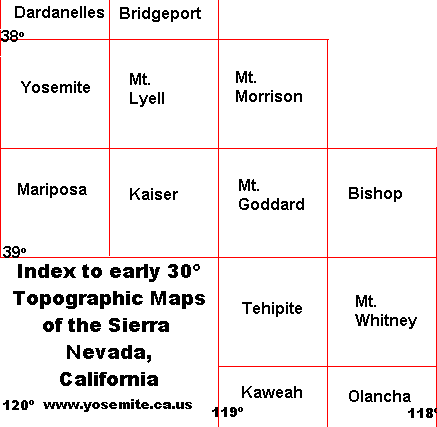
[Editor’s note: for the convenience of modern readers, who don’t have access to 30' topographic maps, I prepared the following index map of the early 19th century topo maps of the Sierra Nevada, California. This map does not appear in the original printed edition—DEA.]
|
|
Next: A • Contents • Previous: Introduction
| Online Library: | Title | Author | California | Geology | History | Indians | Muir | Mountaineering | Nature | Management |
http://www.yosemite.ca.us/library/place_names_of_the_high_sierra/place_names.html