Yosemite Valley, 1892.
Published by the Edinburgh Geographical Institute.
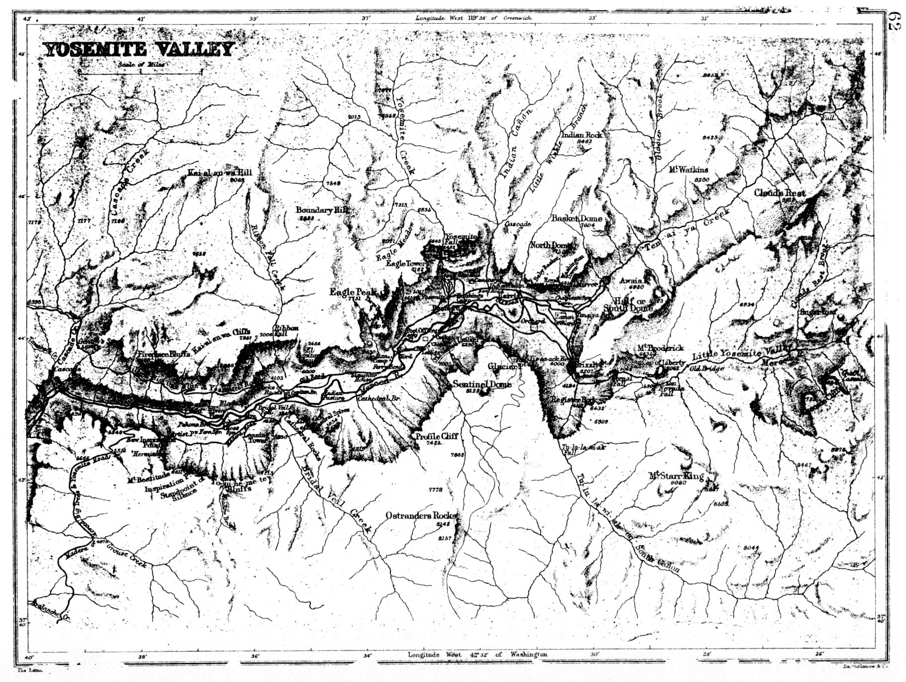
[click to enlarge]
| Online Library: | Title | Author | California | Geology | History | Indians | Muir | Mountaineering | Nature | Management |
Yosemite > Library > Yosemite Resources > Chapter III: Administration of The Yosemite Grant and Yosemite National Park, 1890-1905 >
Next: 4: Cavalry 1905-1915 • Contents • Previous: 2: State Grant 1864-1890
A. The U. S. Army Enters Yosemite 311
1. The U. S. Army Becomes the Regulatory force in the New California Parks 311B. Trails, bridges, and Roads 320
2. Aspects of Military Management 312
3. Contributions of the U. S. Army to the Present National Park System 318
1. Trails and bridges 320C. Construction and Development 349a) Pre-Army Trail System 3202. Toll Roads 341
b) Blazes 321
c) Army Troops Begin Improving routes 325
1. State of California 349D. Natural Resource Management 365a) Pavilion 3492. Concession Operations 349
b) Powerhouse 349a) Wawona Hotel 3493. Sierra Club 354
b) Cosmopolitan Bathhouse and Saloon 350
c) Camp Curry 351
d) Degnan Bakery 352
e) Fiske Studio 352
f) Foley Studio 352
g) Jorgensen Studio 353
h) Boysen Studio 353
i) Best Studio 354
j) Studio of the Three Arrows 354a) Creation of Club 3544. U. S. Army 359
b) LeConte Lodge 357a) New Camp buildings 359
b) Arboretum 360
1. Continuing Charges of Spoliation of Yosemite Valley 365E. A New Transportation Era Begins 388
2. The Sheep Problem 368a) The Sheep industry in the 1890s 3683. Grazing on Park Lands 372
b) Army Measures to Combat Trespassing 370
4. Poaching 373
5. Fish Planting 374
6. Forest Management 377
7. Stream Flow Measurements in Yosemite Valley 377
8. Origins of a Major Conservation Battle 380a) Initiation of the Hetch Hetchy Project 380
b) The Secretary of the interior Denies Mayor Phelan‘s Applications 385
1. Railroad Lines to Yosemite 388F. Private Lands and boundary Changes 391a) Yosemite Short Line Railway Company 388
b) Yosemite Valley Railroad 389
1. The U. S. Army Becomes the Regulatory Force in the New California Parks
Acts of Congress approved 25 September and 1 October 1890 set aside three separate tracts of land in the state of California. The statutes required the Secretary of the Interior, who had exclusive control over the properties, to publish rules and regulations for the preservation from injury of all timber, mineral deposits, and natural curiosities or wonders. He also had to provide against the wanton destruction of the fish and game in the park and against their capture for either merchandising or profit, as well as remove all trespassers.
With the establishment of Yellowstone in 1872 and of Yosemite, Sequoia, and General Grant national parks in 1890, the federal government attempted to initiate a system of national preserves for public use and enjoyment. The 1864 act establishing the Yosemite Grant, however, legislated no “national” laws or appropriations to ensure the execution of the Secretary of Interior’s new and complex responsibilities. In addition, Congress immediately returned to more important Civil War matters without addressing the need for a strict regulatory agent to patrol boundaries, guard the forests and streams, enforce rules and regulations, and generally protect government interests.
Without either a legal system, annual appropriations, or the necessary administrative facilities to accomplish the purposes set forth in the laws, the Secretary of the Interior advised the President of the United States on 4 December 1890 that the best arrangement for preventing timber cutting, sheep herding, trespassing, and spoliation would be to station a troop of cavalry in Yosemite and another in Sequoia to administer it and General Grant. The President approved instituting in those areas an administration similar to that in Yellowstone, and army detachments occupied those parks during part of every year after 1891; until 1900 they operated without congressional sanction.
The precedent for military management of the California parks had been set at Yellowstone National Park. In the first years after establishment of that area, the Department of the Interior had been helpless in preventing spoliation, the civilian administrators having neither the physical nor the legal force to prevent depredations. Although conditions became so appalling that some pessimists called for abandoning this first formal federal experiment in conservation, a few staunch supporters of the idea managed to get a clause included in the Sundry Civil Act of 3 March 1883 that authorized the Secretary of the Interior to request the Secretary of War for troops for the protection and preservation of the park if needed.
In 1886, after Congress refused to appropriate money for Yellowstone’s administration, the Secretary of the Interior did ask the Secretary of War for troops of cavalry to protect the area. That system of military management was so effective that it was later extended to the Yosemite, General Grant, and Sequoia national parks, without a legal basis, however, because the 3 March act did not legally apply to later parks. The military administration of those four parks comprises a unique period in our history, because the army maintained and protected those lands for years without legal sanction or official law enforcement procedures. The army successfully functioned as a civil government—a role never previously or since required of it.
2. Aspects of Military Management
Troops protected and patrolled the California parks only during the summer months, from May to October, in the hopes that the heavy snows of winter would deter intrusion by trespassers during that time. Two troops of cavalry served in the three parks, leaving the Presidio of San Francisco in early May and arriving in the parks two weeks later after an overland march of 250 miles. One troop went south to patrol Sequoia and General Grant parks, the other stayed in Yosemite. The officer in charge of the southern detachment became acting superintendent of the Sequoia National Park, the other officer being designated acting superintendent of the Yosemite National Park. Both submitted annual reports to the Secretary of the Interior. The army never established a permanent military post at Yosemite, only a temporary summer headquarters on the southern boundary near Wawona and a semipermanent post later in Yosemite Valley.
When U. S. troops first occupied the three California parks in 1891, they found conditions very similar to those in Yellowstone. Boundaries were unmarked, roads and trails were practically nonexistent, and people had -for years been availing themselves of hunting, fishing, mining, and grazing opportunities on those vast public lands. The area of army responsibility in Yosemite comprised a huge, relatively uncharted wilderness easily penetrated by trespassers. The cavalry units assigned to Camp A. E. Wood received few instructions on problem solving and little money with which to work. Usually army officers served only one season as acting superintendent and it was difficult within that time to become well acquainted with the park and its needs. After 1897 a new acting superintendent was appointed each year. During one or two periods, as many as three different acting superintendents served within a year. The resulting lack of continuity in policy and in interpretation of the rules, and the fact that each new superintendent had only begun to learn his duties by the time he left, were objectionable features of this system of management. In the absence of a penal code, military commanders often resorted to ingenious expedients and cunning contrivances as a substitute for legal methods.
After Congress provided a legal structure. for Yellowstone Park in 1894, but failed to make the act applicable to the California parks, pleas by California superintendent for additional legislation became more insistent. The Secretary of the Interior forwarded those requests in each of his annual reports to Congress, with no affect. The illegal aspects of using U. S. troops to perform civil duty surfaced again in 1896, when the Secretary of War questioned the Secretary of the Interior’s routine
|
Illustration 43.
Yosemite Valley, 1892. Published by the Edinburgh Geographical Institute. |
|
[click to enlarge] |
For the duration of the Spanish-American War in 1898, the Secretary of War suspended the annual assignment of troops to the parks. During that time a civilian, J. W. Zevely, special inspector for the Department of the Interior, nominally protected the parks. As acting superintendent, he immediately appointed eleven men as forest agents to patrol the park. Four special agents of the General Land Office, under the direction of the Secretary of the Interior, also reported to Zevely for duty. Two of them were each placed in charge of a squad of men in Yosemite and two were dispatched to Sequoia and General Grant parks. Those civilians continued the army’s methods of expelling trespassers, extinguishing fires, and confiscating firearms.
On 1 September army personnel—Capt. Joseph E. Caine and the First Utah Volunteer Cavalry—returned to Yosemite. After those troops left in the fall, funds were found to appoint Archie O. Leonard, early guide and pack train boss in the area, and Charles T. Leidig, first white boy born in Yosemite Valley, as the first official civilian rangers for the park, with direct charge of park matters. They remained in Yosemite throughout the winter and for several years thereafter. During that time they willingly assisted the army troops and became indispensable in the administration of affairs in the park. Meanwhile, opposition to the extra-legal military administration was rising on several quarters and questions mounting in the War Department regarding the legal authorization for such an employment of the army.
Congress became the arbiter of the matter, and by act of 6 June 1900 authorized and directed the Secretary of War, at the request of the Secretary of the Interior, to detail troops to prevent trespassing for any of the purposes declared by the statute to be unlawful. The presence of troops in the California parks finally became legal.
The act of Congress approved 6 February 1905 authorized all persons employed in forest reserves and national parks to make arrests for the violation of rules and regulations. Still no real penalties existed other than expulsion, so that this act was only a beginning. In 1910 the acting superintendents of the California parks appended to the published rules and regulations of Yosemite, Sequoia, and General Grant national parks an excerpt from an act designed to protect Indian reservations and allotments. The portion cited provided a fine and imprisonment for anyone cutting trees or leaving a fire burning upon land reserved by the U. S. for public use. This remained the only piece of punitive legislation available during the military administration of the California parks.
After the recession to the federal government of the Yosemite Valley and Mariposa Grove in 1905, military headquarters moved to a central location in Yosemite Valley and military protection extended throughout the valley and high country. The army continued to detail troops to Sequoia and Yosemite until 1914, when a force of civilian rangers replaced them upon the insistence of the military commanders that conditions had materially altered since the establisment of the parks.
During the twenty-three years between 1891 and 1914, a succession of eighteen army officers (see Appendix E) and various cavalry units functioned admirably as guardians of the meadows, forests, and animal life of Yosemite. The military commanders chosen to perform nonmilitary duties in the parks were men of high caliber who took their trust seriously. Some officers truly distinguished themselves—among them Maj. Harry C. Benson and Maj. William W. Forsyth. Benson, especially, is renowned for his explorations, map making, fish planting, and determination to end the encroachments of sheepmen and cattlemen. He was also the guiding force behind trail location and construction.
Several individuals carried the army tradition into the later civilian administration of the park. Gabriel Sovulewski first came to Yosemite in 1895 as Quartermaster Sergeant with the army. Honorably discharged after service in the Phillipine Islands in 1898, he worked as a civilian guide and packer in Yosemite in 1901. In 1906 he returned as park supervisor and looked after park interests during the winter. He also served as acting superintendent during the early years of civilian administration from 1914 to 1916. Many of the park’s trails and roads were built under his supervision. Subordinate officers and enlisted men, such as Lt. N. F. McClure, also made important contributions in backcountry exploration and map making, while others helped stock the Yosemite rivers and streams with trout. Place-names throughout the High Sierra commemorate many of those army officers and men.
3. Contributions of the U. S. Army to the Present National Park System
The U. S. Army began its work in the California parks during a relatively calm period in world affairs. As a result, troops were regarded less as a combative force than as a peacetime regulatory agent to be called upon in times of need. Initially, a hostile neighboring population, accustomed to free use of public land for grazing, hunting, lumbering, and mining, resented curtailment of those privileges in Yosemite, and in their resentment attempted in every way possible to circumvent the authorities. Attitudes gradually changed through the years, however, and more people became firm believers in preservation and protection of resources through the establishment of national parks.
The United States Army filled a void in early park administration that could not be filled any other way. To a large degree army officers developed the park policy inherited and later refined by the National Park Service. More important, perhaps, without benefit of a well-defined legal system and hampered by the absence of punitive legislation, army troops saved Yosemite, Sequoia, and General Grant national parks from destruction just as they had Yellowstone. At the same time, they managed to instill in the surrounding populace a regard for conservation of America’s natural resources.
Park duty often involved incurring the emnity of homesteaders and cattlemen and sheepmen and occasional hostility from the state Guardian and commissioners. Local interests in the counties surrounding the park affected by the creation of federal forest reservations resented losing thousands of acres of taxable land and valuable timber and mining rights. Relations between them and the various park administrators became more and more strained over the years. Despite the difficulties, park details were not an unattractive burden for either army officers or men. The former relished the relatively autonomous and independent command, and the men enjoyed the pleasant, summer-long relief from routine army duties. Troops also encountered less discipline, drill, and restraint. They became good field soldiers with six months of intensive field training to their credit at the end of each year.
Military authorities made a major contribution toward the conservation of natural resources, managing to convince the public, despite their determined enforcement of regulations by often unorthodox and severe methods, that preservation was necessary and even advantageous. Communities around the parks gradually began to favor strict compliance with the rules, convinced by the acting superintendents of the recreational and economic advantages of park existence.
As their legacy to America’s national parks, the military developed workable administrative procedures; made physical improvements, including the construction of roads, trails, bridges, campgrounds, and administrative buildings; formulated policies on natural resource management, conservation, and protection, and on private lands and leasing; initiated interpretive and naturalist programs; collected and analyzed scientific data; thwarted actions inimical to the interests of the parks; and protected them against the caprices of politicians and wanton destruction by merchants and businessmen. The U. S. Cavalry protected the beginnings of the National Park System when no other source of protection was feasible or available. When ultimately the park ideal gained a foothold and conservation became a natural part of the nation’s thinking, the presence of a military force became inappropriate. At that time, the transition from the military administration to a civil one was less abrupt because many military personnel accepted discharges from the army and became the professional cadre around which the first civilian ranger force formed.
Conditions in Yellowstone had ultimately forced the enactment of a comprehensive organic law for its government, to protect the resources and punish criminals. By the early 1900s such conditions as existed in Yellowstone prior to that ‘legislation appeared in Yosemite, resulting in the inability of the military to efficiently enforce the rules and regulations the Interior Department prescribed. The interests of all concerned, but especially those of the United States, required the enactment of laws suitable for the dignified and orderly government of the parks. Continued military government was not perceived to be the final answer for Yosemite any more than it had been for Yellowstone. Parks required civil administration, which could be most effectively and appropriately provided by the enforcement of suitable laws through an adequate administrative system by qualified civil officials.1
[1. Good information on early army administration of America’s national parks is found in Harold Duane Hampton, “Conservation and Cavalry: A Study of the Role of the United States Army in the Development of a National Park System, 1886-1917,” Ph. D. dissertation, University of Colorado, 1965, which has been used as a source for some of the statements in this section. Also see Hampton, How the U. S. Cavalry Saved Our National Parks (Bloomington: Indiana University Press, 1971). ]
1. Trails and Bridges
a) Pre-Army Trail System
Indian trails connecting Wawona, Glacier Point, Yosemite Valley, and the Sierra uplands comprised the most traveled routes in the Yosemite region when the army took charge. The first detachments found only a few marked trails beyond the rim of Yosemite Valley. Those rough routes had been established first by Indians and then slightly improved by packers transporting goods across the Sierra to miners on the east side, by wandering stock, cattlemen, and miners, and by sheepherders and the packtrains supplying them. The army improved and blazed those routes during their patrols, but also had to forge new ones. Abandonment or rerouting of old trails sometimes became necessary to avoid slides, to improve grades, or to shorten distances. Private contractors constructed many of the new trails as the Interior Department made appropriations available, but army engineers and army labor planned and constructed most of the road and trail systems during those early days. Funds for the construction and repair of trails first became available in 1899, with annual appropriations then following regularly. Lieutenant Colonel Joseph Garrard of the Fourteenth Cavalry was the first acting superintendent (1903) who personally supervised trail construction.
The existing trail system in the Yosemite backcountry had its inception in the early U. S. Army patrol work, with most of the main features of today’s system laid down by 1914. During the army administration, the geography of the Yosemite wilderness was transferred to paper and not simply a part of oral tradition. Because cavalry units assigned to the park changed each year, routes had to be clearly established and mapped early in the military administration to avoid duplication of effort. One interesting aspect of the army’s surveying and mapwork is that it probably caused the loss of many original place names. Early penetrators of the wilderness had bestowed names on certain areas and topographical features that reflected events concerning its discovery or personal experiences involving that site. Those had been in common usage for years, but were gradually replaced in the 1890s with names reflecting new experiences and a new authority. Because of their placement on paper, those new designations became permanent references to particular areas.2
[ 2. James B. Snyder, “Yosemite Wilderness—An Overview,” n.d., typescript, 4 pages, section of draft of Yosemite Wilderness Management Plan, in Yosemite Research Library and Records Center. ]
b) Blazes
A valuable group of resources within Yosemite National Park’s backcountry are the blazes left by individuals who used the
|
Illustration 44.
Outline map of Yosemite Valley. From Hutchings, Yo Semite Valley and the Big Trees, 1894. |
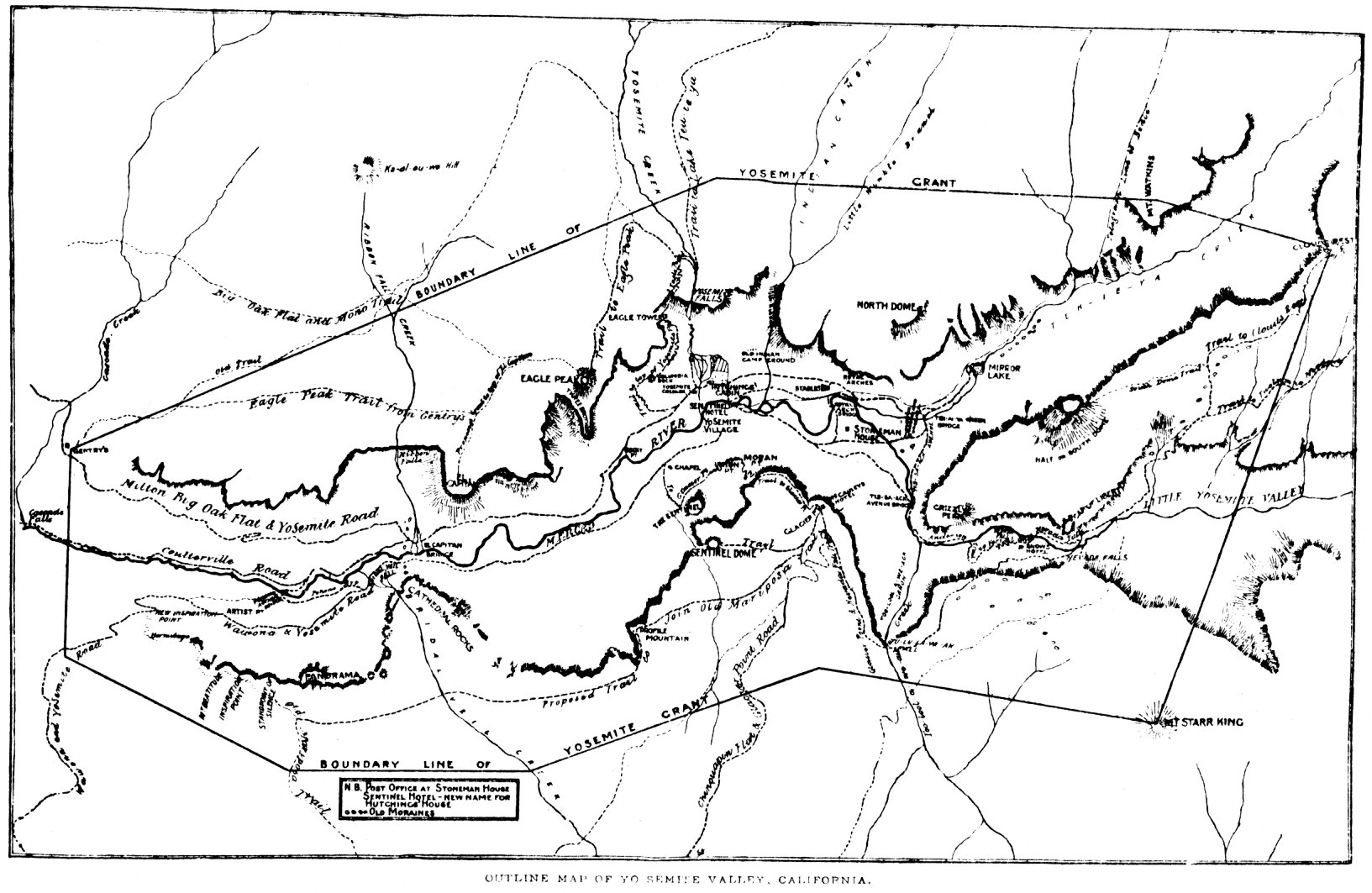
[click to enlarge] |
[3. Allan (Shields?) to Keith (Trexler?), 29 July (1959-60?), Yosemite-Trails, Y-8, Yosemite Research Library and Records Center; John Mahoney to Doug Hubbard, 20 August 1958, in Yosemite Research Library and Records Center.]
[4. Scott Carpenter, Review of Historic Resource Study, 1986, 5.]
[5. Jim Snyder, Historic Resource Study review comments, 1986, 21.]
These blazes are an interesting and significant reminder of undocumented backcountry grazing and mining operations and trailblazing. They indicate areas of concentration as well as early trail marking and map making activities within the park. Presently they are threatened by new wildfire let-burn policies. Many of the earlier sheepherder blazes may also have cultural significance, because most of the carvers were foreign born. Examples of the different types of blazes should be preserved. A record of their locations would be a useful guide to early trails in the region. Probably every year marked trees are dying and falling, resulting in the loss of these symbols of significant exploration and land use.
c) Army Troops Begin Improving Routes
Captain Abram Epperson Wood, commanding Company I, Fourth Cavalry, became the first acting superintendent of Yosemite National Park in 1891 and continued in that position until 1894. Establishing a base camp on the South Fork of the Merced Rivei—later referred to as Camp A. E. Wood—about one mile west of and on’ the opposite bank from the Wawona Hotel, the new administrator proceeded to tackle Yosemite’s problems. He had not been informed of his duties before his arrival, nor were maps of the area provided, necessitating that he purchase a small township map of the park printed in San Francisco so that he could locate the park boundaries! Once he had determined the boundaries, Wood periodically detached units to patrol them for trespassing cattle and sheep.
The road of greatest use to army troops patrolling the park was the “Big Oak Flat and Tioga Road,” which left the Big Oak Flat Road about five miles into the park and continued east to the Sierra crest. Although not much used for the two or three years prior to the army’s arrival and obstructed with fallen trees and washouts, it remained a good mounted trail. Wood’s troops also frequently utilized the section of the Mono Trail that began at Wawona, wound up along the South Fork of the Merced, turned northeast probably in the vicinity of Alder Creek, crossed the main Merced River just above Nevada Fall, and then dropped over the divide between it and the Tuolumne River, crossing the latter at Tuolumne Meadows and then proceeding east over the summit through Bloody Canyon.
Three other trails often served patrol purposes: the Virginia Trail, entering the park probably near Virginia Canyon and heading down toward the Tuolumne River at the lower end of Tuolumne Meadows; a trail from Mount Conness to Tuolumne Meadows; and one
|
Illustration 45.
Diamond and T blazes on lodgepole pine, Ostrander Lake Trail. Photo by Robert C. Pavlik, 1984. |
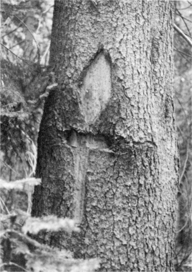
[click to enlarge] |
The track from Mariposa to Hite’s Cove and on into the valley was difficult and seldom used. The army did blaze a few lesser trails in the park to preserve them because they facilitated communications and police work. They mainly comprised old stock trails that would be obliterated as grazing was phased out unless the army accomplished preservation work. One of the most pressing needs of the army was a trail system consisting of a route running around the park inside the boundaries, with other trails branching off to important points, and including log bridges over main streams.
By 1894 the Lower Iron Bridge across the Merced River near where the Big Oak Flat Road entered the valley still had not been rebuilt after collapsing from snow loads years before. That situation forced travelers to follow along the north side of the valley to the Upper Iron Bridge spanning the river almost directly opposite Yosemite Fall. Additionally, Lt. Col. S. B. M. Young, Fourth Cavalry, acting superintendent in 1896, stated that the bridge for saddle and pack animals over the Tuolumne River in the Hetch Hetchy Valley needed to be repaired or abandoned. That structure, of log stringers supported on timber cribs filled with rock and floored with split timber, served as the only means of communication with the section north of the Tuolumne River until August, when the fords became passable. Young also reported the need for two log bridges enabling mounted patrols and pack animals to pass through the southeast section of the park early in the season. Large rocks that covered the streambeds in that region, coupled with strong spring currents, made fording almost impossible.6
[6. S. B. M. Young, Lt. Col, Fourth Cavalry, Report of the Acting Superintendent of the Yosemite National Park to the Secretary of the Interior, 1896 (Washington: Government Printing Office, 1896), 8.]
An act of Congress approved 1899 appropriated $4,000 for the protection of the park and the construction of bridges, fencing, trails, and the improvement of roads other than toll roads. Contracts were immediately entered into for the construction of a bridge across the Merced River and for the repair of a trail from the bridge to its connection with the Coulterville wagon road, a distance of fourteen miles.
In 1901 a new trail, to Dewey Point, followed the south rim of the valley from near Sentinel Dome via The Fissures, across Bridalveil Creek some distance back of Bridalveil Fall, then on to Dewey and Stanford points and the stage road at Fort Monroe. At that time the valley floor contained twenty miles of carriage road and twenty-four miles of saddle trails.7
[7. D. J. Foley, Yosemite Souvenir and Guide (Yosemite, Calif.: “Tourist” Studio-office, 1901), 19, 24, 45, 54.]
By the end of fiscal year 1901, a contractor had nearly completed a bridge over Wet Gulch (exact location unknown), and Acting Superintendent L. A. Craig, Major, Fifteenth Cavalry, recommended repair and/or construction of the following trails and roads:
repair of trail from head of Chilnualna Fall to Devils Post Pile, 38 miles;
construction of trail from Clouds Rest trail to Lake Merced, 5 miles;
repair of trail from Tiltill trail east side of Rancheria Creek to “The Sink” (not located on modern maps, but see McClure’s 1896 map, Illustrations 43-45), 10 miles;
repair of trail from Poopenaut Valley to Lake Eleanor, 9 miles;
repair of trail from headwaters of San Joaquin River to head of Bloody Canyon, 30 miles;
repair of trail from Lake Tenaya to White Cascades on Tuolumne River, 9 miles;
repair of trail from Lake Eleanor to Lake Vernon, 11 miles;
repair of trail from Lake Vernon to Tiltill Valley, 8 miles;
construction of bridge over Tuolumne River near Lembert’s Soda Springs to be used by saddle and pack animals; and
construction of trail from Lake Ostrander to Crescent Lake, 7 miles.8
[8. L. A. Craig, “Report of the Acting Superintendent of the Yosemite National Park,” 10 October 1901, in Annual Reports of the Department of the Interior for the Fiscal Year Ended June 30, 1901. Miscellaneous Reports. Part L Bureau Officers, Etc. (Washington: Government Printing Office, 1901), 552-54.]
Illustrations 46-48. “Map of the Yosemite National Park Prepared for Use of U. S. Troops by N. F. McClure, 1st Lieut., 5th Cavalry, March, 1896.” This map is especially useful for locating early place-names and structures. These three copies show wagon roads, army patrol posts, direction and extent of patrols, routes used by packtrains supplying the posts, and cattle- and sheep-grazing areas. From Letters Received by the Office of the Secretary of the Interior Relating to National Parks, 1872-1907 (Yosemite), RG 79, NA.
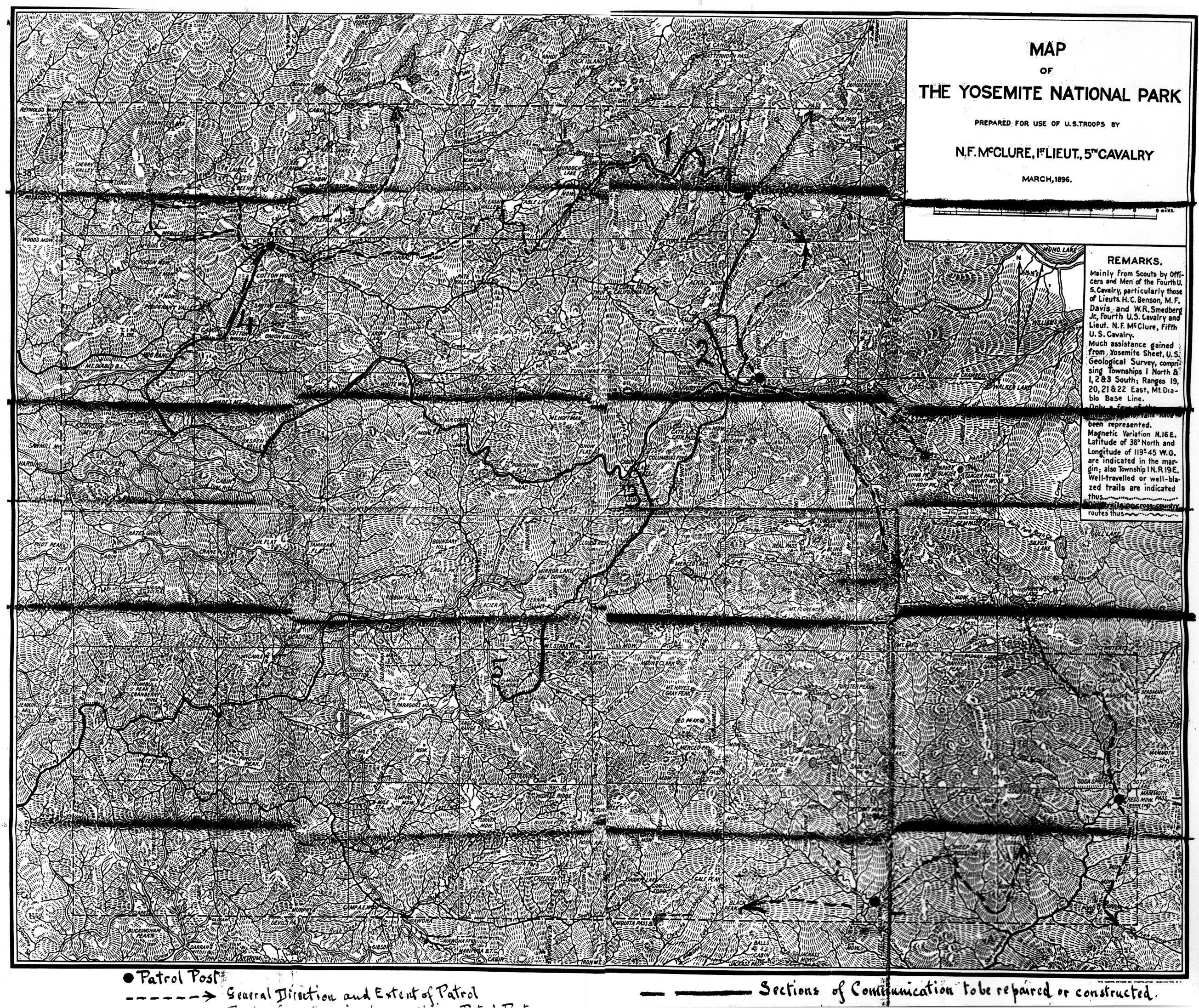
[click to enlarge] |
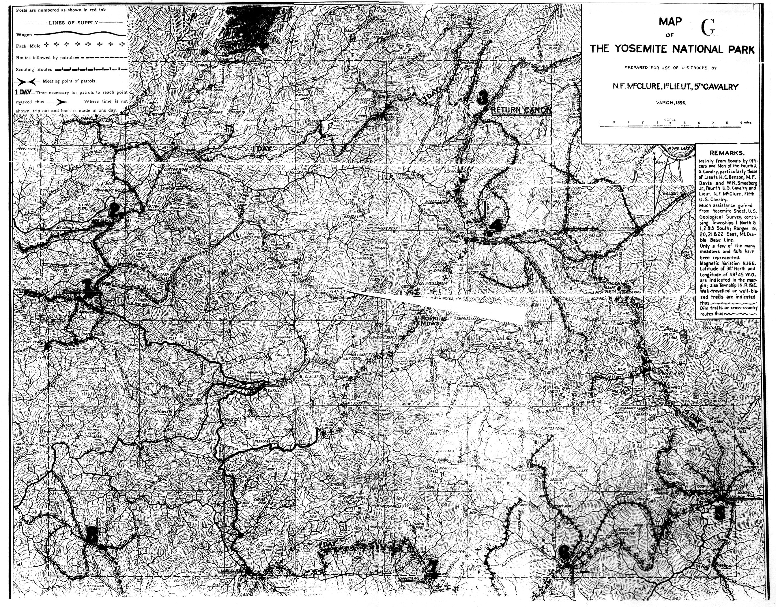
[click to enlarge] |
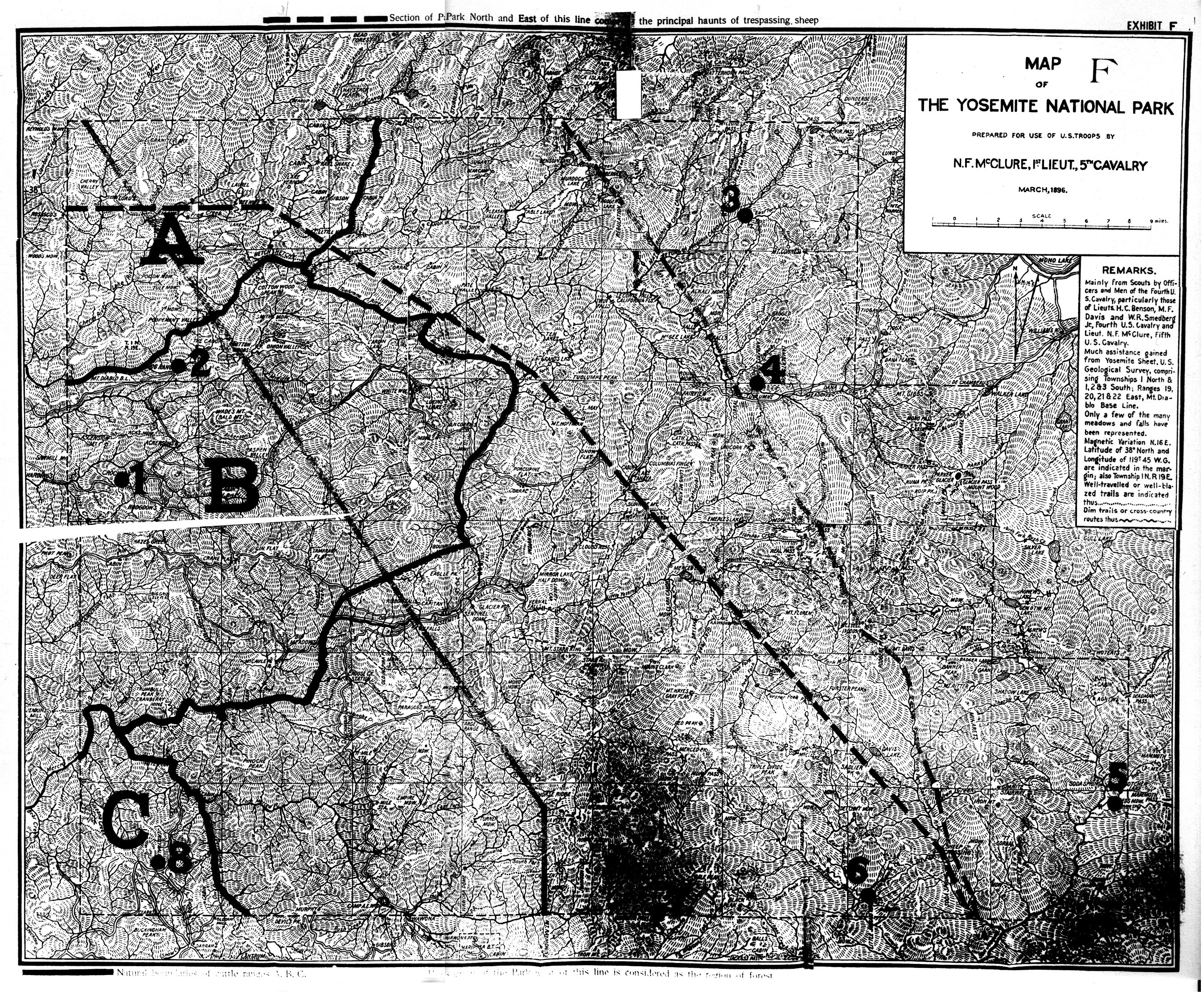
[click to enlarge] |
During fiscal year 1902, the army contracted for construction of several trails:
from Alder Creek to Peregoy Meadow,
from Devils Post Pile to Bloody Canyon,
from Mono Meadow to Lembert’s Soda Springs,
from Ostrander Lake to Crescent Lake,
from Lake Eleanor to Lake Vernon, and
from Lake Vernon to Tiltill Valley.
A bridge was also built over the Tuolumne River near Lembert’s Soda Springs.9
[9. O. L. Hein, Major, Third U. S. Cavalry, Report of the Acting Superintendent of the Yosemite National Park hn California to the Secretary of the Interior, 1902 (Washington: Government Printing Office, 1902), 4.]
During the 1903 season, the establishment of permanent patrolling stations, manned by four to six men each, enabled troops to more thoroughly guard and patrol the park. Captain Benson and the civilian rangers advising him had suggested this system. Subposts, each consisting of one noncommissioned officer and from three to nine privates, were established at Little Jackass, Agnew’s, Lembert’s Soda Springs, Return Creek (above Tuolumne Meadows), in Hetch Hetchy Valley, at Crocker’s, and at Buck Camp.10 Troops serving at those substations were relieved once a month. Detachment commanders made daily patrols to cover all approaches to the park and all territory where sheepmen and poachers might be found. An officer’s patrol visited and inspected each substation at least once a month.
[10. Little Jackass Meadow was part of Yosemite National Park from 1890 to 1905. Its name was changed to Soldier Meadow in 1922. Theodore C. Agnew, a miner, settled in the meadow bearing his name, north of Devils Postpile NM, in 1877. Agnew guided army troops patrolling the park. Peter Browning, Place Names of the Sierra Nevada (Berkeley: Wilderness Press, 1986), 2, 204.]
The building and repairing of trails progressed well during 1903 and all contract work was completed except for the trail from The Sink to Rodgers Lake. Soldiers used axes, hatchets, and saws to open up about sixty miles of trail that had become overgrown or blocked by fallen trees. Expenditures had been made on trails from Poopenaut Valley to Lake Eleanor, from Tenaya Lake via McGee Lake to Smoky Jack Meadows (named for sheepman John Connell), from Rancheria Creek to The Sink, from the west summit of the North Fork of the San Joaquin River to Kings Creek and for a bridge across that river, from near Upper Chilnualna Fall to Johnson and Chiquito lakes, from Rancheria bridge connecting with the Poopenaut trail to Lake Eleanor, and from The Sink to Rodgers Lake. Other work that needed to be done included repairing and tarring the two suspension bridges in the valley of the Merced River near Hennessey’s ranch site.11
[11. Jos. Garrard, Lt. Col., Fourteenth Cavalry, Report of the Acting Superintendent of the Yosemite National Park in California to the Secretary of the Interior, 1903 (Washington: Government Printing Office, 1903), 4-5, 7-8.]
In the first part of the 1904 season, the army again established patrol posts, divided into eastern and western sections, with an officer in command of each. The commander of the eastern one took post at Soda Springs, the commander of the western section remained at Camp A. E. Wood. Each section commander inspected each of his posts at least once during his tour. After all posts had been set up, the patrols of adjoining posts were required to meet and exchange mail or messages every week, resulting in a complete circuit of patrols from the first post back to Camp Wood. Each post patrolled to its front beyond the line of the reservation.
Because small numbers of cattle had been found trespassing in the park, the troops constructed an impoundment corral at Big Oak Flats, near T. H. Carlin’s place on the South Fork of the Tuolumne River. Acting Superintendent Maj. John Bigelow, Jr., requested authority to grant a permit for cattle grazing on government land because he believed that cattle grazing helped diminish forest fires, that cattle trails served as useful fire guards, and that the presence of cattle in the park assured the help of cattlemen and herders in preventing and extinguishing forest fires. He also argued that cattle ranging on government land would lead to the fencing in of the patented lands to exclude those cattle and would thus aid in defining more clearly the metes and bounds of those lands. Bigelow also stated that “cattle are a picturesque feature of the landscape, relieving the monotony of wastes of grass and wood.”12 The only work accomplished on roads or trails during that time involved construction by the troops of a road from the Glacier Point road to Mono Meadow.
[12. John Bigelow, Jr., Major, Ninth Cavalry, “Report of the Acting Superintendent of Yosemite National Park,” 30 June 1904, in Annual Reports of the Department of the Interior for the Fiscal Year Ended June 30, 1904. Miscellaneous Reports. Part L Bureau Officers, Etc. (Washington: Government Printing Office, 1904), 380-81.]
Expenditures incurred up to 15 September 1904 included repairing the trail from Rodgers Lake to Smoky Jack Meadow, constructing a trail from Lembert’s Soda Springs to the Palmer trail, repairing parts of the trail from Hog Ranch to Hetch Hetchy, constructing a trail from Hopkins’s place (Hopkins Meadow—roughly the junction of the Sunrise and Highwater trails below Clouds Rest) to Merced Lake, repairing the trail from Crescent Lake to Johnson Lake, repairing the trail from Chilnualna Fall to its junction with the trail from the “target range,” tarring the suspension bridges over the Merced River and Wet Gulch, and constructing a footbridge over the South Fork of the Merced River near Camp Wood.
On 30 April 1905, Capt. H. C. Benson, Fourth Cavalry, became acting superintendent and reestablished headquarters at Camp A. E. Wood and outposts for patrol purposes in outlying districts—at Crane Flat, Hetch Hetchy Valley, Jack Main Canyon, Aspen Valley, Merced Lake, Soda Springs, and Matterhorn Canyon.
Trails constructed or improved during 1905 led
from a point on the Lake Vernon-Hay Stack Peak trail eastward into Jack Main Canyon and out from Tiltill Mountain to Tiltill Valley;
from a point near Breeze Lakes, via Fernandez Pass and the headwaters of Granite Creek, to Post Peak, Isberg Pass, and down the east bank of the Merced River to Merced Lake;
from a point on the above trail in the McClure Fork Canyon northeastwardly via Vogelsang Peak, Fletcher Lake, and Tuolumne Pass to the Lyell Fork of the Tuolumne where Ireland Creek empties into it; and
from a point in Jack Main Canyon, where the trail from Tiltill Mountain reaches the canyon floor, northeast along the east bank of Fall River, up Jack Main Canyon.
Work on these trails proved very difficult. The new paths were well constructed, however, and their entire lengths could be ridden on horseback. Because all the trails ran at high altitudes, travelers received spectacular views of the park. Other construction included a bridge across Rancheria Creek.
2. Toll Roads
The future of the four toll roads into Yosemite Valley, which passed through the national park, quickly became a topic of discussion among early army administrators. Because the initial road construction had been costly and the severe winters entailed expensive repairs each spring, the various road companies charged high toll rates for passage. To many visitors the payment of tolls entailed an economic hardship when added to the exorbitant prices they had to pay for hay and grain in the valley. In addition, tolls seemed incompatible with the concept of a national resort and recreation area open to all, rich and poor alike. The army believed that federal acquisition of those roads would encourage more public use of the park and would enable maintaining them in proper condition to facilitate the supply of army troops and the discharge of their duties in enforcing the rules and regulations of the park.
Because the roads had been built under the authority of both national and state law, the owners could not be deprived of their property except upon reasonable compensation. The Secretary of the Interior had the power to regulate, but not to prohibit, the taking of tolls on roads in the national park outside of Yosemite Valley. The absolute prohibition by the federal government of levying tolls would be tantamount to confiscation and illegal. The answer to the problem seemed to be appropriate legislation providing for their acquisition and the settlement of any legal claims of the road companies.13
[13. Assistant Attorney General to the Secretary of the Interior, 7 December 1891, in Letters Received by the Office of the Secretary of the Interior Relating to National Parks, 1872-1907 (Yosemite), RG 79, NA, 12-14.]
On 18 February 1892, Secretary of the Interior John Noble sent a letter to A. G. Speer, special agent of the General Land Office in San Francisco. In that communication Noble stated that the Interior Department wished to foster a system of roads and transportation and hotel accommodations that would make visitor excursions to the park as agreeable as possible. At the same time, the department would attempt to be as liberal as possible to all private interests as was compatible with the purposes of Congress in establishing the park.
To that end, Noble directed Speer to consult with Capt. Abram Wood as soon as possible and obtain information on the condition, origin, and right of franchise of all the toll roads within the park as well as on their convenience and use to the public. Noble also requested that Speer meet with the various owners and managers of the toll roads to enable them to make their claims to recognition by the Department of the Interior.
In the summer of 1892, Capt. John S. Stidger, a special agent from the General Land Office, and Maj. Eugene F. Weigel joined Speer and Wood in that endeavor, with Weigel, a special land inspector of the Interior Department, also detailed to investigate the condition of affairs in Yosemite Valley. On 24 September Speer was relieved of official duty and Captain Stidger directed to continue the work relating to the toll roads with Weigel and Wood. In his 3 October 1892 report to Noble concerning Yosemite Valley, Weigel noted that the toll roads in and outside of the park were very annoying to travelers and recommended that the federal government acquire all such roads within the limits of the national park.
On 21 October 1892 representatives of the four toll roads—the Big Oak Flat and Yosemite Road, the Coulterville and Yosemite Road, the Great Sierra Wagon Road, and the Yosemite Stage and Turnpike Road—met Weigel, Wood, and Stidger at the U. S. Land Office in San Francisco and presented them with statements from the corporations owning those roads, showing their condition, franchise rights, length, cost, rates of toll, and so forth. In his report to Noble of 15 November Stidger suggested that the United States government follow the example set by the state of California and purchase and open to free use all the roads within the boundaries of Yosemite National Park. Congressional representatives from California and the Executive Committee of the Yosemite Board of Commissioners also made pleas to that end, citing federal money that had been appropriated for roads and bridges at Yellowstone National Park and at the National Military Park embracing the Chickamauga and Chattanooga battlefields.14
[14. Senators and Representatives in the U. S. Congress from California to the Honorable Hoke Smith, Secretary of the Interior, ca. 16 October 1895, in Letters Received by the Office of the Secretary of the Interior Relating to National Parks, 1872-1907 (Yosemite), RG 79, NA, 1-7.]
House bill 7872 and Senate bill 3675, relative to the purchase and opening to free traffic of the four private toll roads in Yosemite National Park and to the building of other necessary new roads by the government, were introduced in the Fifty-fifth Congress. The House referred the former to the Committee on Public Lands, which reported favorably on it and recommended passage by the House of Representatives. The pressure of business in the House was such that neither Senate bill 3675, which had passed the Senate, nor House bill 7872 could be reached, and neither was passed by the Fifty-fifth Congress.
A substitute measure, however, in the form of an amendment to the “Act making appropriations for sundry civil expenses of the Government,” passed on 3 March 1899. That provision, in addition to providing $4,000 as mentioned earlier for the protection of the park and for specific construction and improvement work, also provided that the Secretary of War expend some of the money to appoint three commissioners to examine and collect data on the existing toll roads; on new wagon roads from Yosemite Valley to Merced, Mariposa, and Tuolumne counties; on a new wagon road connecting the Tioga Road with roads in Mono or Inyo counties; and on a wagon road to Hetch Hetchy Valley.
Secretary of War Russell A. Alger appointed the requested Yosemite National Park Commission on 28 April 1899, composed of Col. Samuel M. Mansfield, Corps of Engineers, U. S. A.; Capt. Harry C. Benson; and J. R. Price, of the Department of Highways of the state of California. Just prior to the commencement of the commission’s work, Mr. Price ceased to be a member of the Department of Highways and retired from the commission. Joseph L. Maude, commissioner of highways of the state, succeeded him. The commission performed its work during the summer and fall of 1899 and reported to the Secretary of the Interior on 4 December.15
[15. The commission’s report was printed by order of the Senate as Senate Doc. 155, 56th Congress, 1st session. ]
The commission pointed out that up until 1890 little attention had been paid to the country surrounding Yosemite Valley. Now, however, the tolls demanded by owners of the only access routes restricted travel into the new national park. The government’s duty entailed either purchasing the existing roads or constructing new toll-free ones. If the latter course were chosen, the existing road owners would have to be compensated in some way, because the construction of free roads would divert all travel from the toll roads and would constitute practically a confiscation of the existing toll roads. It would be advantageous, anyway, the commission argued, for the government to own all entry roads into the park to ensure proper control of traffic.
The commission also found that the existing roads used for patrol purposes were not adequate for smooth communication between the troops guarding the park. The construction of additional roads would also lessen the cost of transportation of supplies to the troops and enable better fire control. Eliminating tolls on all the existing roads and constructing new ones would also enable visitors as well as the military to reach all sections of the park. Suggested new roads led: from the Tuolumne Soda Springs on the Tioga Road, along the Lyell Fork of the Tuolumne, to the foot of Lyell Glacier; from the Mono Valley to the Tioga Road via either Mill Creek, Lee Vining, or Bloody canyons; from Tenaya Lake, on the Tioga Road, down Tenaya Creek Canyon to the floor of Yosemite Valley; and from Yosemite Valley, utilizing the existing road to The Cascades, west down the Merced River canyon. The latter road, providing access from the Mono Valley on the east to the San Joaquin Valley on the west, would be easier and faster than any existing routes and would remain open through the entire year. The road down Tenaya Creek Canyon would shorten the distance between Yosemite Valley and Soda Springs and avoid the high altitude of the Tioga Road at Snow Flat.
Since the establishment of Yosemite National Park in 1890, $8,000 had been appropriated out of the public treasury for its maintenance, half of this sum in 1898 and half a year later. The first $4,000 funded a special civilian detail to prevent trespassing by sheep and cattle within the park limits while the U. S. Cavalry, usually charged with that duty, fought in the Philippine Islands; the latter amount had been expended in defraying the expenses of the Yosemite National Park Commission. Californians felt that Congress should be more liberal in its appropriations for the development of Yosemite, commensurate with the state’s contributions to the public treasury. They recommended renewed efforts toward purchasing at fair value and eliminating tolls on the four toll roads into Yosemite and building the new road from Merced Falls to
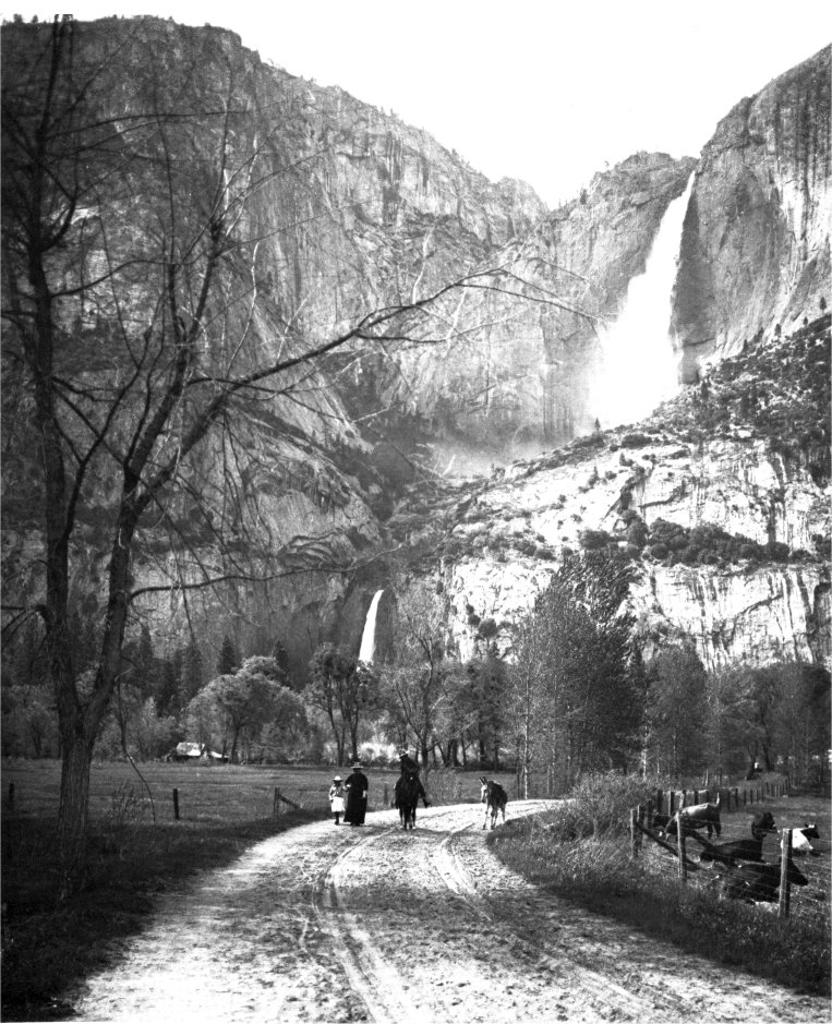
|
Illustration 49.
Yosemite Valley floor, ca. 1900. Postcards published by Flying Spur Press, Yosemite, California. |
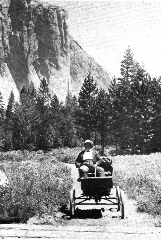
Illustration 50.
First automobile in Yosemite Valley, 1900. |
[click to enlarge] |
[click to enlarge] |
[16. John T. McLean, A Brief Statement, Showing how properly California has kept the conditions of the trust upon which it accepted the grant of the Yosemite Valley. . . . How munificently the Nation, through Congress, has treated its other National Parks . . .; what undeserved neglect the Yosemite National Park has had . . .; and, a Plea That the same care and consideration should be given to The Yosemite Park. . . . (Washington: Globe Printing Company, 1900), 15-21, 26-28, in Letters Received by the Office of the Secretary of the Interior Relating to National Parks, 1872-1907 (Yosemite), RG 79, NA.
This statement was prepared by McLean and printed as an argument for appropriations by Congress to make the park toll roads free and for the construction of such new roads as were necessary to make all parts of the park accessible. It was first to be read at a meeting of the California congressional delegation held on 16 April 1900 and subsequently circulated among members of Congress in Washington and among state officers and members of the California press.]
With the publication of the commission’s report, and in line with the annual reports and official letters of various secretaries of the interior between the years 1892 and 1898 declaring it to be government policy that all roads traversing national parks should be free, the California congressional delegation decided to act. It determined to request sufficient appropriations to buy the private roads in the park and to build at least the proposed new road from Merced Falls up the Merced River canyon to Yosemite Valley. The California State Legislature, in an extra session, unanimously passed Assembly Concurrent Resolution, No. 2, introduced by the Committee on Roads and Highways, on 7 February 1900. That resolution, regarding appropriations for roads in and about Yosemite National Park, instructed the California congressional delegation in Washington to take whatever action it thought necessary to secure proper appropriations for the necessary improvements to the park in accordance with the report of the three federal commissioners.
1. State of California
a) Pavilion
During the 1901 season, the Yosemite commissioners built an open-air dance floor, or pavilion, on the riverbank near the Guardian’s office in the Old Village. Lighted by electricity, it served for all sorts of public functions, especially for the dancing socials held twice a week during the summer and fall.
b) Powerhouse
In 1902 the state built an electric light and power plant on one of the Happy Isles. The Yosemite commissioners managed the plant, which had cost about $30,000. The plant was housed in a permanent frame building. Water to run the operation was diverted from the river to the powerhouse through an imbedded iron pipeline. In the plant it turned against a pelton wheel with sufficient head to operate the system. The building had a concrete floor containing imbedded wooden beams to which were bolted the generators and the frames holding the pelton wheels. In 1905 the California state attorney general ruled that the electric light plant was a permanent fixture of the valley and that title thereto passed to the United States under the terms of the recession act.17
[17. U. S. Webb, Attorney General, to Hon. J. J. Lermen, Sec. of Comm. to Manage Yosemite Valley 23 July 1906, in Letters Received by the Office of the Secretary of the Interior Relating to National Parks, 1872-1907 (Yosemite), RG 79, NA, 6.]
2. Concession Operations
a) Wawona Hotel
Sometime prior to 1894, the Washburns erected “Little Brown,” a two-story cottage with cupola east of the main hotel. Early in 1891 they and J. J. Cook and his son formed the Wawona Hotel Company to manage the hotel and the farming, bartering, and other commercial interests associated with it. About 1899 construction began on “Long Brown” (present Washburn Cottage) east of Long White (Clark Cottage).
b) Cosmopolitan Bathhouse and Saloon
After the Cosmopolitan ceased to operate in the 1880s, the premises served various purposes. The front of the building became the office and living quarters of the Guardian of the valley, occupied in turn by Walter E. Dennison, Mark L. McCord, Galen Clark, and Miles Wallace. The final two Guardians under the state—John F. Stevens and George T. Harlow, from 1899 to 1906, lived in a new building slightly east of the Old Village general store.
During Clark’s second administration as Guardian, 1889 to 1897, his office in the Cosmopolitan’s front room functioned as a club or lounge for the men of the village and occasional visitors. There, gathered around a large table and huge stove, they passed the time catching up on valley affairs. Occasionally assemblies, such as school programs and community parties, took place in another large room near the center of the building. (Even in Smith’s time, his saloon had frequently been the site of local gatherings.)
The excess space in the Cosmopolitan building not needed by the Guardian provided extra sleeping quarters in connection with the Sentinel Hotel and also served as the hotel barroom and barber shop. A section in the rear of the building became a small bunkhouse for workmen. The bunkhouse, barroom, and barber shop were collectively referred to as the “Collar and Elbow.” After the Guardian’s office and living quarters moved to the new headquarters building, the front part of the Cosmopolitan functioned variously as a post office and express office, and served whatever other needs arose.18
[18. Degnan to McHenry, 17 November 1954.]
c) Camp Curry
In 1899 two teachers came to Yosemite who had begun using their summer vacations to manage camping tours of the West. David A. and Jennie Foster Curry had settled in Redwood City, California, in 1898. Having become enamoured of mountain country through classes in nature lore taken under David Starr Jordan at Indiana University, they had for several seasons arranged and conducted tours through Yellowstone Park, in which small parties moved from place to place with camp equipment and baggage.
In 1899 they decided to spend the summer in Yosemite and establish a camp there. With seven sleeping tents and a larger one to serve as dining room and kitchen, and with the assistance only of a cook and students from Stanford University working for room and board, the Currys originated an idea in tourist service that revolutionized hostelry operations in Yosemite and other national parks. Their first camp stood on the site of present Camp Curry.
The success of this hotel/camp arrangement was immediately apparent. What began as a summer camping operation to accommodate a few paying guests turned into much more than that as more than 290 people registered the first year, necessitating the addition of eighteen more tents. Dependency on the railroad and a two-week round trip by wagons and mules to Merced for supplies made operation of the camp difficult, but the reasonable rates and informal hospitality brought patrons back year after year. Evening campfire entertainments proved popular from the beginning, gradually becoming more structured with regular entertainment programs. During one of the first summers of operation, Curry revived McCauley’s firefall tradition on a regular basis. By 1901 a large dining room and rustic office had been built. The Currys adopted the distinctive Adirondack rustic style for their earliest permanent buildings. Characterized by stick and bark panelling, the style later appeared on the Yosemite Valley Railroad Station at El Portal and on the railroad’s office in Yosemite Valley. The original registration office built in 1904 is now used as a lounge. Postal facilities have also been incorporated on the north side. Its rustic style is characterized by unpeeled logs, vertical posts, and horizontal beams, with strips of natural cedar bark in a herringbone pattern as a decorative element.
d) Degnan Bakery
By 1894 John Degnan was cultivating Lamon’s upper orchard and the family lived in a small frame house near the site of Lamon’s original cabin for a few months. After the family moved back to the Old Village, John continued to work for the state and do odd construction jobs for the hotels and stage companies. In 1898 Degnan built a new house on the site of the old J. J. Westfall meat market. In the bakery attached to the rear of their house, Bridget prepared bread for sale in a brick oven that yielded 100 loaves per baking. The Degnans sold these and other baked goods through the store.19
[19. Degnan to Hubbard, 24 February 1956.]
e) Fiske Studio
In May 1904 fire destroyed George Fiske’s Yosemite home, resulting in the loss of its furnishings in addition to his lenses, cameras, and entire collection of West Coast negatives. Fiske rebuilt, although it is unclear whether in the same area, north of the Four-Mile trailhead and about one mile from the Old Village, or in the Old Village, where a 1920 map shows a residence referred to as Fiske’s house.20
[20. Ansel F. Hall, Guide to Yosemite: A Handbook of the Trails and Roads of Yosemite Valley and the Adjacent Region. (Yosemite National Park: National ‘Park Service, 1920), 9.]
f) Foley Studio
D. J. Foley established a print shop and photographic studio in 1891 and published a souvenir paper titled The Yosemite Tourist beginning in that year. He also sold Foley’s Yosemite Souvenir and Guide. His building, known as the Yosemite Tourist Printing Office and Studio, stood just west of the superintendent’s office. (After his death, Mrs. Foley continued the business into the 1940s.)
g) Jorgensen Studio
Artist Chris Jorgensen first came to Yosemite Valley in 1898 and camped two summers before building his first cottage—a studio and residence—on the north bank of the Merced River in 1900. He built a one-story, one-room log structure, “the bungalow,” in 1903 on the opposite side of the river from the Sentinel Hotel and a short distance above the bridge. He also had a barn and storehouse on his land. This new residence had a wood shingle-covered gable roof, with the front decorative gable end projecting ten feet beyond the front wall of the cabin. Its walls consisted of peeled logs in alternating tiers and contained an original stained glass window. Jorgensen, a noted painter, maintained a seasonal residence and studio in the valley for twenty years.21
[21. In 1962 the Park Service razed the earlier Jorgensen studio and residence and moved the later bungalow to the Yosemite Pioneer History Center, believing it to be the studio building. It is, therefore, the Jorgensen home that has been preserved rather than his studio. Mary Vocelka, Research Librarian, Yosemite Research Library and Records Center, Comments on the Historic Resource Study, 8 January 1987, 1.]
h) Boysen Studio
While the valley was under state control, J. T. Boysen received a concession to conduct a photographic studio. He had come to the valley about 1898 and had supplied photos of the valley and of the Mariposa Big Tree Grove to the World Exposition at St. Louis and at the Lewis and Clark Exposition in Portland. His first two years he conducted his business in a tent, but when the commissioners ruled that there would be no more tents along the main avenue in 1900, he built a small studio of unfinished lumber west of the superintendent’s office between D. J. Foley’s Studio and Salter’s store. Boysen concentrated on photographing the Mariposa Grove and the Yosemite Indians. The Yosemite Park and Curry Company bought his studio in 1943.
i) Best Studio
In the spring of 1901 landscape painter Harry C. Best came to Yosemite, and, after marrying a young lady he had met in the valley, applied for a permit from the Yosemite commissioners to sell photographs and paintings. In the season of 1902 the couple set up a tent studio near the government pavilion in the Old Village.
j) Studio of the Three Arrows
In the winter of 1902, Harold A. Taylor, who had arrived in the valley the preceding April as assistant to Julius Boysen, and Eugene Hallett, agent for the Santa Fe stage line, formed the Hallett-Taylor Company and took over the business and building of Oliver Lippincott. They named their place the ‘’studio of the Three Arrows,” because Taylor’s family crest centered around three arrows, and, in addition, the name seemed an appropriate motif for the valley because of its Indian history. The photographic business stood across the street from the Degnan home and bakery.
3. Sierra Club
a) Creation of Club
Although John Muir and other conservationists had been highly delighted by the preservation of the Yosemite high country through establishment of the national park, they continued to worry that forces bent on the exploitation of the fledgling national parks would continue to agitate for mineral, timber, water, and homestead rights. They began to think in terms of some sort of unified organization to combat those aggressions and lobby for preservation of the wilderness. At the same time, a growing number of people in California started to express an interest in hiking and exploring the Sierra. What they needed was an organization to provide maps and material related to mountaineering. It seemed logical, ultimately, for the two groups with such similar interests to join and form a mountaineering club—a Sierra club—to work toward the preservation of California’s natural wonders, especially those of the Yosemite region.
On 4 June 1892 those individuals formed the Sierra Club, with John Muir as president, to explore the mountain regions of the Pacific Coast, to publish reliable information concerning that area, and to enlist the cooperation of the people and government in preserving the forests and other natural features of the Sierra Nevada. It took a while for the club to get going. Despite its periodic meetings and publication of a Bulletin beginning in 1893, interest in it gradually began to wane. In 1897 the Sierra Club asked that it be allowed to establish headquarters in Yosemite Valley where it could provide maps and other data to visitors. The club also was considering laying out short trips and arranging excursions to the high country. A year later it reached an agreement with the Board of Yosemite Commissioners that the latter would repair the Sinning cottage on the opposite side of the road from the Sentinel Hotel for the Sierra Club’s use as a general information bureau. The club then furnished the house and provided publications, maps, and collections relating to the High Sierra. The club and the board of commissioners equally bore the salary for a summer attendant, who would man the bureau for the club and also assist the Guardian by directing campers to campgrounds and by dispensing 2 general information on the valley to visitors in the Guardian’s absence.22
[22. J. N. LeConte and Charles A. Bailey to the President and Board of Directors of the Sierra Club, 9 June 1898, in “Notes and Correspondence,” Sierra Club Bulletin II, no. 4 (June 1898): 239.]The idea of sponsoring mountain excursions seemed the most likely prospect for reinvigorating the club. The idea received only minimal consideration, however, until the arrival of William E. Colby on the scene. In 1900 Colby, a lawyer and enthusiastic hiker who eventually became a leader in the Sierra Club, envisioned leading organized outings into the High Sierra. President Muir agreed with the suggestion and made Colby chairman of the Outing Committee. They scheduled the first official Sierra Club Outing for Tuolumne Meadows in the summer of 1901. As plans got underway, a new member, Edward Parsons, joined the club. A successful businessman and accomplished mountaineer, he was already a member of several prestigious mountaineering groups when he joined the Sierra Club. Immediately becoming a member of the Outing Committee, he and Colby led hundreds of hikers into the mountains over the next several years. Colby served forty-four years as secretary of the club and two as president. For sixteen years he served as an active member of the Yosemite Advisory Board.
That first Sierra Club outing, consisting of rugged day-long expeditions into the surrounding mountains from a base camp in Tuolumne Meadows, initiated a special kind of social and instructive institution in the Sierra Nevada. Club members returned year after year for the popular trips and developed life-long friendships amid the active social programs and the serious study of nature pursued through reading assignments and natural history lectures by Muir and other experts around the evening campfire. The trips were intended not only to attract new members and provide a pleasant recreational experience, but also to instill in club members an appreciation of the beauty and inspiration of the mountains and a desire to defend them from all threats of spoliation. Soda Springs, where the Sierra Club established a campground and later a lodge, became the center of field activities for Sierra Club members. The club sponsored various summer and winter activities in that area, including hiking, sightseeing, cross-country skiing, and mountaineering. The Sierra Club’s outings had a strong impact on backcountry use, providing the impetus for additional trail building and map work.
In general, the Sierra Club aimed at the promotion of both a recreational and aesthetic appreciation of the High Sierra country, but it was especially protective of Yosemite. Its genuine concern for the future of that great preserve became apparent during the battles over recession of the Yosemite Grant and development of the Hetch Hetchy Valley. The Sierra Club’s dedication to the preservation of Yosemite National Park would be severely tested during that last controversy. The club’s leading members, although disheartened by the outcome of the issue, nevertheless in the course of the entire affair acquired a knowledge of political processes and skills in political maneuvering that would prove invaluable in the future. The club itself acquired a reputation that provided it with considerable influence and ensured its participation in important policy-making decisions on conservation matters related to the public domain.23
[23. Jones, John Muir and the Sierra Club, 168-69. After John Muir’s death in 1914, the Sierra Club became primarily a social organization, losing some of its established ties with mountaineering. After 1916 it often aligned itself with the National Park Service, two of its illustrious members being Californians Stephen Mather and Horace Albright. It tended to refrain, however, from active participation in conservation battles by the mid-1930s and into the 1940s, although it reemerged during the 1960s in the forefront of the modern American conservation movement. Stephen Fox, John Muir and His Legacy: The American Conservation Movement (Boston, Toronto: Little, Brown -and Company, 1981), 214, 272.]
b) LeConte Lodge
On 6 July 1901 Joseph LeConte, the eminent scientist and noted professor of geology and natural history at the University of California, an early director of the Sierra Club who spent much of his time studying the Sierra and the geology of Yosemite, died at Camp Curry in Yosemite Valley.
The directors of the Sierra Club appointed a commission, consisting of Professors A. C. Lawson and William R. Dudley, Dr. Edward R. Taylor, Elliott McAllister, and William E. Colby, to decide upon an appropriate memorial. The committee decided that, rather than building a conventional memorial, it would be more appropriate, based on LeConte’s active and useful life, to erect a lodge to serve as a reminder of LeConte and also be of direct benefit to others.
Large groups of Professor LeConte’s friends contributed to the $5,000 fund necessary for construction, including many prominent San Francisco merchants; the student body, alumni, and faculty of the University of California; members of the faculty of Stanford University; mining engineers; geologists; LeConte’s relatives and personal friends; and members of the Sierra Club. Although they raised several thousand dollars, a few hundred were still lacking. As a result, the directors of the Sierra Club levied an assessment on club members of $1.00 each. LeConte’s widow provided the last $200 needed in the form of twenty-eight gold nuggets that had been given Dr. LeConte on his golden wedding anniversary by several former pupils in South Africa.
The LeConte Memorial Lodge, finished in September 1903 at a cost of $4,714 and dedicated on 3 July 1904, had a picturesque and unique character that attracted great interest. The architect, John White, donated both his plans and his time to the work. The finished structure, containing a variety of design features, nonetheless blended harmoniously with its environment. Located behind Camp Curry and under the walls of Glacier Point on a gentle slope against a background of trees, the lodge entrance provided a fine view of Half Dome. The structure became the Sierra Club’s headquarters in Yosemite Valley during the summers and contained a portion of the club library as well as maps and photographs. A custodian provided information to visitors on the club and surrounding mountains from May to July.
Local rough-hewn granite formed the foundations, walls, and chimney of the structure. As much of the rock’s weathered surface as possible faced the exterior. Broad granite steps led to a “Dutch” entrance door. The main reading room measured thirty-six by twenty-five feet with a huge granite fireplace at one end surrounded by bookcases and window seats. Interior roof beams were left exposed and rough finished. The unique reading room table, measuring nine by five feet, had a heavy top supported by two sections of the unbarked trunk of a large yellow pine.24
[24. William E. Colby, “The Completed LeConte Memorial Lodge,” Sierra Club Bulletin 5 (1904-1905), no. 1 (January 1904) (San Francisco: The Sierra Club, 1950), 66-69.]
4. U. S. Army
a) New Camp Buildings
The U. S. Army used the present site of the A. E. Wood Campground on the South Fork of the Merced River near Wawona as its main camp and administrative headquarters from 1891 until 1907, when the troops moved into Yosemite Valley. Captain Abram Wood established the first army post on 17 May 1891 and called it “Camp near Wawona.” Its designation changed to “Camp A. E. Wood” in 1901.25 In the beginning, tents and other temporary structures, which were usually destroyed by campers and other trespassers during the winter, sheltered the troops and their equipment. A desperate need existed for a permanent building for housing and to allow storage of equipment so that it would not have to be transported back to San Francisco each year. Little construction took place the first few years, although troops did construct a horse shed in 1901.
[25. Register of Letters Received, 1912, and Letters Received, 1912-13, RG 393, Records of the U. S. Army Commands (Army Posts), NA. Camp A. E. Wood became “Camp Yosemite” when it moved into Yosemite Valley in May 1907. The army abandoned the latter post 31 October 1913.]
As stated earlier, in 1904, in the vicinity of the camp, the soldiers built a footbridge across Big Creek, which is no longer extant. A simple two-plank-wide structure, it provided access to the arboretum, described below. Another bridge in course of construction by the troops that season crossed the South Fork of the Merced River. Troops also added an office/storeroom and corral that year.
In 1905 the War Department allotted $3,000 for the improvement of Camp A. E. Wood. This funded installation of a water supply system and the construction of numerous buildings, including kitchens and mess halls, commissary and quartermaster storehouses, a stable extension, and a bathhouse. The army purchased lumber for the sides and roofs, but the soldiers obtained the construction timbers from nearby forests. During the year the troops also built a packtrain stable, a laundry, and a wagon shed, the material for those buildings obtained through the seizure of several thousand shakes illegally cut on government land. The troops quartered in floored Sibley tents, and enjoyed ranges and other equipment necessary for their comfort during a protracted stay.26
[26. Report on Yosemite National Park, under “National Parks and Reservations,” in Annual Reports of the Department of the Interior for the Fiscal Year Ended June 30, 1905. Report of the Secretary of the Interior and Bureau Offices, Etc. (Washington: Government Printing Office, 1905), 165.]
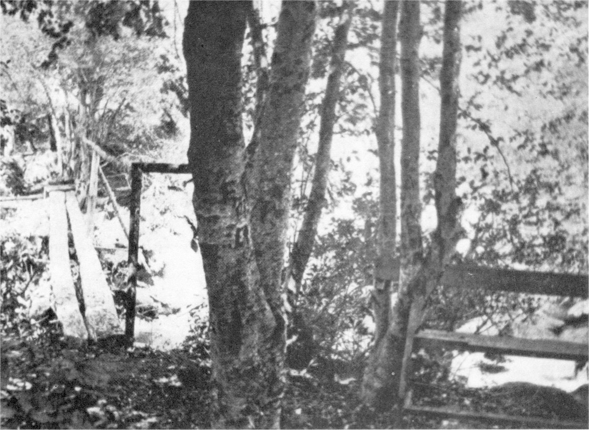
b) Arboretum
Major John Bigelow, Jr., acting superintendent of Yosemite National Park, constructed an arboretum and botanical garden in 1904 close to Camp A. E. Wood. Bigelow described the arboretum as bounded on the north by the south side of the South Fork of the Merced River, on the east by property of the Wawona Hotel, on the south by the southern boundary of the park, and on the west by a line running north-south from a point between the two bridges at Camp Wood and the southern boundary of the park. It covered an area of roughly 75 to 100 acres. On its eastern boundary, Big Creek, which furnished drinking water to the army camp via a flume and pipe, ran northward into the Merced River. An old trail followed up the right bank of Big Creek about one-half mile to where the water entered the flume, while another old trail connecting the Wawona Hotel and the camp passed through the arboretum from east to west.
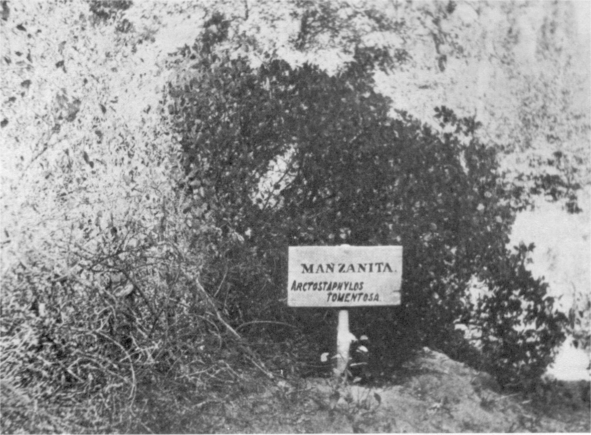
Bigelow had guideposts erected to assist visitors in finding their way to and through the arboretum and several seats constructed to provide opportunities for sitting and studying the various plantings. He intended to fence in the area to keep out loose stock. Labels and signs adorned the trees and marked the plants. The signs consisted of one-inch plank, double coated on both sides with light-brown paint, which bore English and Latin names in dark brown letters 1% to 2 inches high. The labels were nailed to the trees, and the signs nailed to posts that were painted light brown and charred where they entered the ground. White metal tags measuring about 3 inches by 3/4-inch bore the names of the flowers. Bigelow put First Lieutenant and Assistant Surgeon Henry F. Pipes in charge of the arboretum, who had no particular training as a botanist but evinced great enthusiasm for the project.
By late fall 1904 troops had improved the arboretum by posting more signs and labels, opening up paths, erecting signposts and seats, trimming trees, and removing dead wood. Thirty-six trees and plants had been marked, as well as two prehistoric Indian bedrock mortar sites within the arboretum acreage, and a number of plants had been identified for transplanting in the arboretum.
The order instituting the arboretum designated that an officer be detailed to take charge of it, assisted by a noncommissioned officer and one private detailed on special duty. Their responsibilities included guarding the grounds against trespassers; marking samples of the various species of trees, flowers, and plants found in the arboretum with both their English and Latin names; and planting in the arboretum, as far as practicable, other varieties of interesting plants found within the park boundaries.27
[27. Appendix, Exhibit A, in Bigelow, “Report of the Acting Superintendent of Yosemite National Park,” 23 September 1904, in Annual Reports of the Department of the Interior for the Fiscal Year Ended June 30, 1904, 395-97. ]
Bigelow, very interested in natural history and especially in trees, intended that the arboretum develop into a prominent feature of the park and some day be supplemented by a building serving as a museum and library. This accorded with his belief that one of the essential purposes of the Yosemite forest reservation was to provide a museum of nature for the general public free of cost, to display not only trees, but everything associated with them, in nature, including animals, minerals, and geological features.
|
Illustration 51.
Wawona arboretum, 1904. Footbridge over Big Creek at left, bench built onto trees at right. |
[click to enlarge] |
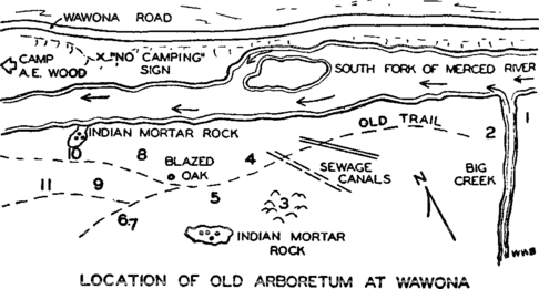
| LOCATION OF OLD ARBORETUM AT WAWONA |
[click to enlarge] |
|
Illustration 52.
Wawona arboretum, 1904. Sign on post identifies “Manzanita.” Photographer unknown. |
[click to enlarge] |
The year after the arboretum’s establishment, however, the boundary change of 7 February 1905 excluded the patented land on which it lay, on the south side of the Merced River, from the park. Acting Superintendent H. C. Benson at that time attempted to gather and store for future use within the park as many of the identifying signs as possible, although some had already been knocked down by surveyors for a projected railroad into the region. (See discussion of Fresno Traction Company later in this chapter.) In 1929 Ranger J. N. Morris rediscovered the arboretum, neglected for years, and found twenty trees still bore labels. The area became part of the park again with the Wawona Basin addition of 1932.
The arboretum project remains significant as an initial attempt to interpret for visitors and other interested people the botanical features of Yosemite National Park, sixteen years before Dr. Harold C. Bryant began the nature-guide service in Yosemite that became the nucleus of the present naturalist interpretive program of the National Park Service. The arboretum complex included the first self-guiding nature trail in the National Park System.
At its height, the arboretum complex consisted only of the two bridges mentioned, several rustic benches, the labels that identified plantings, and the interpretive signs that guided visitors. The flat area to the east, between the hillside and the Merced River, became the site of a sewage treatment facility for the Wawona Hotel, which considerably changed the appearance of the area. Sewage canals were placed prior to 1951, and a sewage treatment pond with a pump, a pumphouse, and a spray field was later installed on the hillside above. Today there are few traces left of the arboretum. A few signs can still be found with some searching, although the bulk of them have been removed or weathered away, as have the benches built for contemplation of the plantings. The trails are now overgrown and almost impossible to distinguish.28
[28. Other sources of information on this interesting enterprise are J. N. Morris, “An Old Nature Trail is Found Near Wawona,” Yosemite Nature Notes 9, no. 3 (March 1930): 17-18; Sargent, Wawona’s Yesterdays, 18; and O. L. Wallis, “Yosemite’s Pioneer Arboretum,” Yosemite Nature Notes 30, no. 9 (September 1951): 83-85.]
1. Continuing Charges of Spoliation of Yosemite Valley
On 22 September 1890 the U. S. Senate adopted a resolution that the Secretary of the Interior report to the Senate as to whether the lands turned over to the state of California in 1864 had been spoliated or otherwise diverted from the public use stipulated by the grant. If so, the Secretary was to determine what steps would be necessary and proper in order to ensure the prevention of further spoliation and the return of the valley to public use.
Congress made no appropriation to enable the Secretary to prosecute his inquiries, and so he pursued the problem primarily through correspondence. He sent letters of inquiry to persons of good repute who he thought probably knew details about the situation in Yosemite. He perused reports and printed statements on the subject, as well as photographs of the valley.
The general concensus of the people asked for opinions seemed to be that
1) there had been a general and indiscriminate destruction of timber in the valley, for building material, to prepare land for plowing, to open up views, and for fuel;
2) from one-half to four-fifths of the valley had been fenced with barbed wire and planted in grass or grain, confining, travel to narrow limits between the fences and the cliffs;
3) many rare plants had been destroyed by pasturing animals and plowing;
4) the management of the valley had fallen into the hands of a monopoly, with no competition permitted for hotel accommodations, transportation, or animal fodder;
5) the only land available for grazing was used by stock of the stable and transportation men so that no grazing lands existed for the mounts of visitors;
6) the high country had been abandoned to sheepherders, whose fires had damaged trees and shrubs, and to their flocks, which had eaten the grasses and herbage down to the bare dirt; and
7) the Big Tree Grove had been severely damaged by fires, with little effort made by the commissioners to extinguish them.
The Secretary of the Interior concluded that the commissioners intended to cultivate as much land on the valley floor as possible to augment the state revenues, even though that action diverted most of the floor from use as a public resort. That was contrary to the intent of Congress, which had stipulated that all features be perpetuated in their original beauty and that only as much of the valley be leased as was absolutely necessary for appropriate buildings for the comfortable entertainment of tourists and other visitors, hopefully with only minimal marring of natural features. The Secretary of the Interior believed that the matter merited further examination and recommended that a committee be authorized to make additional investigations.29
[29. John W. Noble, Letter from the Secretary of the Interior, jjn Response to Senate resolution of September 22, 1890, relative to the alleged spoliation of lands granted to the State of California, 30 January 1891, 52d Congress, 2d Session, Ex. Doc. No. 67, in Letters Received by the Office of the Secretary of the Interior Relating to National Parks, 1872-1907 (Yosemite), RG 79, NA, 1-4.]
On 2 March 1891 the Senate directed the Secretary of the Interior to continue the inquiry and to report his final conclusions to the next session of Congress. Still no appropriation materialized and little further happened until again the Secretary of the Interior called for money and authority to conduct a full-scale investigation. Finally Major Weigel was detailed to make the requisite investigation on the condition of affairs in the valley. He submitted his final report 3 October 1892.
Weigel concluded that much of the natural beauty of the Yosemite area had been compromised through unscientific and indiscriminate land management practices; that more drives and walks were needed; that many of the old, unsightly buildings should be removed; that hotel, stabling, and transportation charges ran too high; and that generally most residents of nearby counties favored valley administration reverting to the federal government. The toll roads and other transportation monopolies, plus exorbitant prices for other goods, made the park practically inaccessible to those with limited time and money.
Another report, dated 15 November 1892, submitted by Captain Stidger, stated that speculation, traffic, and gain comprised the dominating features of the state management. Stidger recommended that the state of California be asked to relinquish its trust and that the valley and the national park be placed under the rules and regulations that governed Yellowstone National Park.
Noble suggested that the facts in those two special reports, in conjunction with the evidence and photos transmitted in his January 1891 report to the Senate, incontestably showed that the state commissioners worked only with an eye to profit and not the preservation of the scenic and botanic wonders of the valley. He recommended that the valley be reconveyed to the federal government and put under the same management as the surrounding national park.30
[30. John W. Noble, Letter from the Secretary of the Interior, un Response to Senate resolution of September 22, 1890, relative to the supposed spoliation of lands granted to the State of California in 1864, 29 December 1892, 52d Congress, 2d Session, Ex. Doc. No. 22, in Letters Received by the Office of the Secretary of the Interior Relating to National Parks, 1872-1907 (Yosemite), RG 79, NA, 1-7.]
2. The Sheep Problem
a) The Sheep Industry in the 1890s
Although cattle owners seemed generally willing to abide by the new anti-trespassing regulations for the park imposed by the army, the annual sheep migrations to the vicinity of the park did not lessen. By mid-June 1891 Captain Wood estimated that nearly 90,000 sheep hovered close to the park boundaries, driven up from the San Joaquin Valley and the coast. Bands numbered 2,000 to 3,000, each accompanied by an outfit of from three to five herders and their dogs, with pack animals carrying supplies. The herders, and many of the owners, were foreigners — Portuguese, Chileans, French, Mexicans, and Basques. Sheep owners tended to use different groups at different times.
Problems related to sheep grazing became a major issue in the early days of the national parks. This was a period of extensive cattle- and sheep raising in California, and owners were accustomed to having their own way when it came to pasturing their animals. Although California sheepmen had imported animals to sell to hungry miners during the Gold Rush of 1849, by the late 1850s the state’s sheep industry revolved around the production of wool. Initially acres of uninhabited cheap land in the San Joaquin Valley provided an abundance of unfettered pasturage. Flocks numbering in the tens of thousands ranged over a vast territory in central California, covering Los Angeles, Santa Barbara, San Luis Obispo, Kern, Tulare, Fresno, Merced, San Joaquin, Colusa, Yuba, Sutter, Butte, and Tehama counties. Because of the vast sheep population, however, the danger of depasturage of grazing lands became acute. Beginning in the 1860s, farmers and fruit growers began squeezing the herds west toward the foothills or south toward the lower part of the state. This coupled with several severe droughts compelled sheep raisers to annually remove their stock to the mountains for summer feeding. This practice of seasonal migrations allowed further growth and development of the sheep industry. The wild, rugged nature of the Sierra backcountry seemed to make it worthless for cultivation but perfect for sheep pasturing because of that animal’s ability to feed upon the sparse vegetation in precipitous canyons and gulches. Sheep owners, therefore, viewed the establishment of national parks and later efforts to enlarge them with alarm, and their immediate response to the new edicts entailed determining how seriously they would be enforced.
Herders reached the summer pastures via a long trail along the east slope of the Sierra, eventually looping through the mountains by way of the passes near Yosemite. Sometimes the herds went as far north as Lake Tahoe before turning west. The trail began at Mojave, with flocks feeding into it from areas even farther south. Central Valley owners drove their herds down the west side of the valley to Bakersfield and over the Tehachapi Mountains to join the migration. The trail then wound its way up the Owens River valley to Bishop, Lone Pine, and on up to Mono Lake, while herders outfitted for the Sierra meadows along the way. Other herds migrated via the central valley and western foothills and returned to their lambing stations along the eastern slope of the Sierra.
Mexicans, Basques, and Portuguese were considered the best sheepherders. They lived a solitary, but not arduous, life, most of their time after the migration spent in sitting or sleeping and watching over the flocks, for which duty they depended a great deal on their dogs. Consequently, they had much free time for handicrafts, such as braiding horsehair ornaments or carving. Once a week while they were in the mountains a foreman came around to replenish supplies.
Soon after the establishment of Yosemite National Park, Author Mary Austin asked a sheepherder where he proposed to pasture his flock. “Jacques” laughingly responded that he would continue to feed his sheep as always by bribing the army patrol with whiskey, taking off the sheep bells, being careful of fires, and taking his chances on getting caught. Miss Austin reflected that the long custom of the sheepmen to pasture in the high country had established in their eyes a “right” to those particular meadows. The sheepmen always held the advantage over their pursuers because they knew the country better, with its secret trails and hidden glens. The army remained hindered by an inadequate patrol force and the lack of severe penalties for grazing on the reserve. As Miss Austin put it, “An ordinance slackly enforced is lightly respected.”31
[31. Mary Austin, The Flock (Boston and New York: Houghton, Mifflin and Co., 1906), 191-99. Other good information on the early sheep industry can be found in Henry Camille Blaud, The Basques, A Thesis, College of the Pacific, 1957. Reproduced in 1974 by R and E Research Associates, San Francisco and Saratoga, California; Charles M. Chase, “The Live Stock Interests of California,” in California (San Francisco: California State Board of Trade, 1897-98), 80-84; James E. Perkins, Sheep Husbandry in California. A Paper Presented Before the California State Agricultural Society (San Francisco: Towne & Bacon, 1863); Major W. Shepherd, R. E., Prairie Experiences im Handling Cattle and Sheep (London: Chapman and Hall, Ltd., 1884); Charles Howard Shinn, “With the Sheep, in California,” (March 1891, excerpt, source unknown), 483-89; and Edward N. Wentworth, America’s Sheep Trails: History, Personalities (Ames, Iowa: The Iowa State College Press, 1948).]
b) Army Measures to Combat Trespassing
The immediate damage sheep inflicted on the mountain meadows was enormous. The vast herds overgrazed, crushed vegetation and soil, and cut rutlike trails with their sharp hooves that hastened erosion of the hills. These destructive activities little concerned the flock owners or their herdsmen. The 1890s brought disruption to the industry in the form of falling wool prices, further decreases in open winter range, transportation changes, and the prohibition of sheep grazing in the Sierra Forest Reserve set aside on the west flank of the Sierra in 1893 and the Yosemite and Sequoia national parks established in 1890. Just as the cattlemen were used to their own way in the highlands, the sheepherders who had used the Sierra meadows for years refused to recognize the new governmental boundaries and regulations. Ultimately the prohibition of sheep grazing in national parks and restrictions on their pasturage in national forests, in addition to other subtler changes within the industry, would end this large-scale sheep grazing.32
[32. Hal Roth, Pathway in the Sky: The Story of the John Muir Trail, (Berkeley: Howell-North Books, 1965), 15-17.]
Realizing his limitations in terms of patrol manpower and the army’s ability to enforce penalties for trespassing, Captain Wood decided that he must take some plan of action to thoroughly frighten the owners as well as the herders of these flocks. That action consisted of having his patrols arrest and bring to camp any herders and their dogs found willfully trespassing after having been warned against the practice. Wood required owners to furnish bonds for their herders’ release. That procedure appeared to Wood to alleviate the problem for a short while.
When the herders realized that the army merely warned them and then set them loose, however, they merely determined that the next time they would not get caught, and cheerfully returned to their old practices. A stronger tactic the army formalized beginning in 1904 was to drive the herd outside the park at the point where it was found, transport the offending sheepherder to the opposite boundary of the park and set him loose, and drive the rest of the outfit off in another direction. That practice necessitated a long, inconvenient, and expensive roundup time for the sheepherder to retrieve his scattered flock and left it vulnerable, meanwhile, to the depredations of predators. It also proved only a stopgap measure, however, because soon after reorganizing the flocks, the herders usually returned.
What resulted was the involvement of the United States Army in an endless game of hide-and-seek over an enormous tract of almost inaccessible mountain territory with a formidable number of unterrified, thoroughly resentful, sheepherders who became extremely cautious and even more cunning in their transgressions. The sheepmen often banded together and hired men as spies to monitor army movements and warn of the approach of patrols. At that instant the sheep, which were grazing just inside the park boundary, would be driven outside in time to avoid detection. Knowing no punitive law existed to cover their case, sheepherders risked expulsion from the reservation, with its attendant inconveniences, rather than forego the advantage of free grazing on the public domain. The situation was exasperating for both sides. Although acting park superintendents continually urged the Department of the Interior to formulate strict penalities consisting of fines or jail terms for trespass, it invoked no such policy.
3. Grazing on Park Lands
The use of patented lands within the park posed another problem for army administrators. Acting Superintendent L. A. Craig, Major, Fifteenth Cavalry, enclosed in his 1901 report to the Secretary of the Interior an extract of a petition sent to the Department of the Interior by property owners regarding grazing on Yosemite parklands. Those people who grazed cattle and horses in the park usually entered upon their lands in April or May and remained until mid-October, when they returned to their Central Valley ranches. In the park, the animals grazed within given confines, such as along mountain ridges or rivers. The patented lands held stock during the October roundups.
The petition for allowing grazing in the park under the same restrictions as placed on stock grazing within the forest reserves primarily argued that grazing would better preserve the park and its natural conditions. Forest fires could be more easily avoided because animal trails served as fire breaks and because, by eating the grass and underbrush, the stock destroyed much flammable material. Since grazing privileges had been disallowed, the undergrowth in the park had grown so thick that it loomed as a potential fire hazard and also proved less beneficial in conserving snow load. Stock owners also argued that game was becoming scarcer in the park each year, due to the destruction of bird eggs and young deer by predators, which previously had fed on horse and cattle carcasses.
Craig himself did not object to property owners and those leasing land within the park limits grazing cattle near their premises under the supervision of park authorities, but only from 1 August to 1 October and only after the owners had obtained permits from the acting superintendent defining the number of cattle involved, their brands, and the limits of their authorized ranges which were not to include park meadowlands.33
[33. Craig, “Report of the Acting Superintendent,” 1901, 552-54.]
4. Poaching
Although the army protected fish and wildlife during the summer, often hunters, trappers, and fishermen waited to enter the park after the troops departure in the fall. Colonel S. B. M. Young took an active interest in the problem of hunters and trappers during his 1896 tenure as acting superintendent. When Young’s men arrived in the summer, they found that hunters and trappers during the winter and spring had killed large quantities of game. To his distress, Young found that both game and song birds had been shot and that fish in their spawning beds had been killed by explosives. The angry Young refused from then on to issue permits to carry firearms within the park and had his patrol parties disarm anyone found carrying them. The removal of firearms, in addition to a reduction in predators in the surrounding region, resulted in an increase of quail and grouse, and Young hoped that the deer, bear, lynx, fox, raccoon, tree squirrels, and chipmunks would similarly multiply and eventually lose their fear of man so that they could be studied in their natural state.34 When charges were made that some of the army troops were killing game, the superintendent stripped the men of their carbines and armed them with revolvers instead.
[34. Young, Report of the Acting Superintendent of the Yosemite National Park, 1896, 3-4, 8.]
Young also established an outlying camp near Crocker’s Station on the Big Oak Flat Road to more readily patrol that larger portion of the park. Later superintendents maintained the guard at Crocker’s because it enabled the seizure of firearms brought over the Big Oak Flat and Coulterville roads, the instruction of campers as to rules and regulations before they entered the park, and the escort of cattle brought in on permits to graze on patented lands. In 1897 Acting Superintendent Alexander Rodgers mentioned another poaching probiem—the killing of deer every fall by Indians coming into the park from Nevada.35 During the 1903 season, Rangers Leidig and Leonard became deputy fish commissioners of the state, empowered to make arrests for all violations of the state laws affecting fish and game.
[35. Alex. Rodgers, Report of the Acting Superintendent of the Yosemite National Park to the Secretary of the Interior for the Year Ended June 30, 1897 (Washington: Government Printing Office, 1897), 4.]
5. Fish Planting
The date of the first unofficial planting of fish in the waters of the Yosemite region is uncertain. As early as 1867 the Mariposa Gazette lamented
that the creeks and lakes in this section of the country [Yosemite region] are destitute of fish. The Tuolumne is a charming stream here but contains no fish. I think our statesmen ought to consider whether supplying these lakes artificially with fish would not be a popular and profitable mode of spending the funds of the State.36
[36. “Grizzly Gulch Correspondence,” Mariposa (Calif.) Gazette, 21 September 1867.]
When the army entered Yosemite, it found fish in the Merced River in Yosemite Valley, in the South Fork near Wawona, and up the Tuolumne River as far as the Hetch Hetchy falls. None existed in the tributaries or lakes above the valley’s rim because of the insurmountable obstacle to ascension presented by the waterfalls. The two commonest species of fish that existed inside the present park boundaries were the rainbow trout and the Sacramento sucker. There are references to private individuals introducing trout into barren waters, a practice followed by homesteaders, miners, stockmen, sheepherders, and sportsmen in the high country to supplement the food obtained by hunting. Homesteader Horace G. Kibbe stocked Lakes Eleanor, Laurel, and Vernon in the northwest section of the park with trout about 1877 and John L. Murphy planted trout in Tenaya Lake a year or so later. Sheepherders may also have transferred trout from certain streams to others nearer their summer campgrounds. Such individual efforts sufficed on a limited basis but did not meet the needs of the general public. The California Fish and Game Commission was organized in 1870 to improve hunting and fishing in the state and also to conserve certain specimens of fish, birds, and mammals from extinction.
Although fish commissioners brought in trout as early as 1879, the first official fish planting in the park took place in 1892 when W. H. Shebley of the California Fish Commission brought a shipment of cutthroat, Eastern brook, and rainbow trout from the Sisson Hatchery in Siskiyou County (now the Mt. Shasta hatchery) to Raymond by train. From there it went by stage to Wawona and then in an army ambulance wagon to Mono Meadow. There the fish were transferred into cans, strapped onto packmules, and taken to various watercourses, including Merced and Ostrander lakes and Bridalveil Creek.37 The army became intensively involved in these fish planting procedures that initiated the later park fisheries program. Early in June 1895 the California Fish and Game Commission sent 30,000 Eastern brook trout that Deputy Arthur G. Fletcher of the State Board of Fish Commissioners put in Yosemite’s streams, assisted by an army detail. The commission also established a small hatchery near Wawona to provide fish for the park lakes and streams, and the army continued to aid Fletcher in stocking the majority of the main streams and lakes in the park that were originally barren of fish with rainbow and cutthroat trout.
[37. H. C. Bryant, “Early Trout Plantings in Yosemite,” Yosemite Nature Notes 9, no. 1 (January 1930): 16; A. E. Borell, “History of Fishing in Yosemite,” Yosemite Nature Notes 13, no. 8 (August 1934): 57-59; Willis A. Evans, Orthello L. Wallis, and Glenn D. Gallison, Fishes of Yosemite National Park (Yosemite National Park: Yosemite Natural History Association, 1944), rev. 1958 and 1961. The introduction of exotic game fishes into the Yosemite area comprised an attempt to establish fish in barren waters and later to supplement the stock in heavily fished areas. Seven species of game fish have been introduced; the rainbow, golden, brook, brown, cutthroat, and Dolly Varden trout and the American grayling. Evans et al., 4.]
The Yosemite-Raymond Stage Line (Washburn interests) installed the Wawona fish hatchery, a wooden superstructure on a stone foundation, and turned it over to the California Fish and Game Commission on condition that it hatch and distribute 500,000 trout eggs annually. M. L. Cross managed the station for several years, while the Washburn brothers kept the facility in repair, their main desire being to stock the streams and lakes in the vicinity of Wawona. Eggs were shipped in from outside sources. The station operated every year except 1897, the output of trout fry consisting of rainbow, mykiss, loch leven, and Eastern brook. The fish generally had to be planted before the end of July, at which time the water warmed rapidly, promoting the growth of algae.
Colonel Benson (acting superintendent 1905-1908) and his troops actively distributed trout throughout the barren streams and lakes of Yosemite National Park. During the early years of fish distribution, fingerlings often were not carried much beyond Yosemite Valley. During the 1905 season, however, Acting Superintendent Benson transported the fingerlings from 70 to 100 miles away before distributing them. He and his men placed 60,000 in Washburn Lake on the Merced River; 60,000 in the Middle and South forks of the Tuolumne River; 30,000 in Ostrander Lake and Bridalveil Creek; and 30,000 in Rush Creek. In addition Benson netted fish in lakes and rivers that he had originally planted when he was a subaltern in the park from 1895 to 1897 and transported them to other areas. The Wawona hatchery closed in 1928 when the Fish and Game Commission thought campers had contaminated Big Creek, the hatchery’s only water source.38
[38. “Wawona Hatchery—1895-1928,” from Earl Leitritz, A History of California’s Fish Hatcheries, Fish Bulletin 150 (Sacramento: Department of Fish and Game, no date), 23.]
6. Forest Management
Colonel Young, in his 1896 report to the Secretary of the Interior, pointed out that the floor of the forests and groves in the park, filled with fallen leaves, twigs, resinous cones, trunks, and branches, and covered over with assorted foliage and undergrowth, conducted flames quickly during the dry season. This covering also, however, preserved, increased, and equalized the water supply by retarding surface drainage and evaporation by the winds. To destroy that cover by spot burning early in the season when fires could be controlled, as a preventative against later forest fires in the dry season, destroyed that natural regulatory process, the preservation of which was one of the prime reasons for establishing forest reserves. Young, therefore, strictly enforced section 2 of the congressional act of 1 October 1890, which stated that the area’s flora, trees, animals, birds, and fish be preserved from any interference by man.39
[39. Young, Report of the Acting Superintendent, 1896, 5.]
7. Stream Flow Measurements in Yosemite Valley
An interesting data collection process had its beginnings in 1904 when the Yosemite Valley commissioners, desirous of having discharge stations established on several of the principal streams in the valley, began working with the hydrographic branch of the U. S. Geological
|
Illustration 53.
Staff water gauge at Pohono Bridge. Photo by Robert C. Pavlik, 1985. |
[click to enlarge] |
In July of that year E. A. Chandler and N. W. Currie erected staff gauges on Yosemite Creek, Tenaya Creek, and on the Merced River at Sentinel Bridge. Chandler served as the Nevada state engineer, employed by the Geological Survey to help with cooperative work. Currie functioned as valley electrician and had the job of recording daily readings of the stream gauges and taking occasional discharge measurements with a current meter. That exercise would result in a continuous gauge record so that the daily discharges of the valley streams could be published weekly in the daily papers throughout the state as a matter of interest to people who might want to visit the valley when the streams were full and the waterfalls at their best.
As it turned out, Currie made only one discharge measurement at each of the stations after installation and kept daily gauge readings only until the end of September 1904. At that time he stopped work upon the advice of the Guardian of the grant, probably because, as an uncompensated extra duty, it conflicted with his other responsibilities.
8. Origins of a Major Conservation Battle
a) Initiation of the Hetch Hetchy Project
Although the ramifications of this issue would not be fully comprehended for a few years, the incredibly complex and controversial Hetch Hetchy Project, a plan evolved by the city and county of San Francisco to provide a municipal water supply, had its beginnings in 1901-2. The Secretary of the Interior had authority to permit the use of rights-of-way prior to this time, but that authority was originally limited to those rights-of-way extending through public lands, as distinguished from reservations and parks. The act of Congress approved 15 February 1901 authorized him to extend those permits to forest and other reservations, and to the Yosemite, Sequoia, and General Grant national parks. Specifically, it empowered him
to permit the use of rights of way through the public lands, forest and other reservations of the United States, and the Yosemite, Sequoia and General Grant National Parks, California . . . for canals, ditches, pipes and pipe lines, flumes, tunnels, or other water conduits, and for water plants, dams and reservoirs used to promote irrigation or mining or quarrying, or the manufacturing or cutting of timber or lumber, or the supplying of water for domestic, public, or any other beneficial uses . . . by any citizen, association, or corporation of the United States. . . .40
[40. Act approved 15 February 1901 (31 Stat. L. 790), quoted in “Memorandum as to Power of the Secretary of the Interior to Authorize the Construction by the United States, Under the Reclamation Act of June 17, 1902, of a Reservoir Within the Yosemite National Park,” ca. February 1905, in Letters Received by the Office of the Secretary of the Interior Relating to National Parks, 1872-1907 (Yosemite), RG 79, NA, 1.]
The San Francisco Water Works had built the city of San Francisco’s earliest large-scale water supply system in 1857 to provide water for the semi-arid Bay region. It brought the water of Lobos Creek, a small stream draining the northwesterly section of the city, by wooden flume to a pumping station on the bay shore at Black Point. From there the water was raised to reservoirs on Russian Hill, from which it was distributed through a system of pipes. Use of this water stopped in 1893 due to increasing contamination.
The Spring Valley Water Works began operations in 1860, running south into San Mateo County and beginning development of the Peninsula System of the San Francisco Water Department. It consolidated with the San Francisco Water Works in 1865 and operated under the name of the Spring Valley Water Company. Its first water supply came from Pilarcitos Creek in the mountains of San Mateo County, south of San Francisco. There a dam was constructed and reservoir formed from which a thirty-two-mile flume conveyed water to the city. The company built additional dams and steel pipes from time to time, ultimately developing the water sources on the San Francisco peninsula to their economic limit.
As early as 1871 city engineers realized that the water resources of the region were inadequate for future needs. Within the Coast Range, the regions south and east of San Francisco Bay had no surplus water, while streams to the north remained inaccessible. The problem constantly resurfaced as dry seasons and fires recurred. In addition, controversies continually arose between the water company and city officials over rates and service. The Spring Valley Water Company and the Contra Costa Water Company, which delivered water to Oakland, Alameda, and Berkeley, enjoyed a monopoly of the water supply business, charging unusually high prices. Public opinion greatly favored obtaining municipal control of that public utility. Also, located near centers of population and human activity, the Spring Valley Company’s sources became subject to increasing pollution.
Although the city had attempted to negotiate with the Spring Valley Company for its sale, as the city charter required before the construction of independent utilities, the company remained unwilling to sell. Meanwhile it acquired water rights in Calaveras Valley and in Alameda and Santa Clara counties. The next step was to Alameda Creek, across San Francisco Bay, in 1887, from which a pipeline connected with the Peninsula System.
It became apparent, however, that the Spring Valley supply could not be increased indefinitely, that the only satisfactory solution to the problem lay in municipal ownership, and that the city would eventually have to resort to the Sierra Nevada -for a larger capacity water supply, despite the challenges posed by transporting that water 150 miles.
The impetus for San Francisco’s application for reservoir rights-of-way in Hetch Hetchy Valley and at Lake Eleanor as a source of domestic water supply resided in the new city charter, effective 8 January 1900, which imposed upon its legislative officers the obligation to submit proposals for the acquisition of a municipal water supply. That prompted an examination of existing and available sources in 1901.
In that year the municipal authorities chose the upper Tuolumne River as the best source of this future supply because of the abundance of water, the possibilities of a large reservoir site, the best electric power potential, the seeming impossibility of future contamination, the fact that its utilization involved only the use of waste floodwaters beyond the ultimate demands of all other dependent industries, and because all other sources appeared inferior to this one in purity as well as being encumbered with prior rights.41 The source of the Tuolumne River was a permanent glacier on Mount Lyell. Draining more than 650 square miles of watershed, the river flowed westerly through the northern part of Yosemite National Park and through Stanislaus National Forest, emerging from the foothills near La Grange and eventually emptying into the San Joaquin River.
[41. “In the Matter of the Application of The City and County of San Francisco For Reservoir Rights of Way in Hetch Hetchy Valley and Lake Eleanor Within the Yosemite National Park. Reply to Objections of the Honorable Secretaries of the Interior and of Commerce and Labor. On Behalf of the City and County of San Francisco,” 17 July 1905, in Letters Received by the Office of the Secretary of the Interior Relating to National Parks, 1872-1907 (Yosemite), RG 79, NA, 1-5; City and County of San Francisco, Public Utilities Commission, San Francisco Water and Power, September 1967, in Box 85 (Hetch Hetchy), Yosemite Research Library and Records Center, 6-8. ]
The Hetch Hetchy Valley, through which the Tuolumne River flowed, lay near the northwest corner of the park. By the early twentieth century, it remained relatively unknown to the majority of visitors to Yosemite Valley, although those few who had inspected it firsthand compared it favorably to the latter place in scenic beauty. Josiah Whitney of the California Geological Survey and Lt. Montgomery Macomb of the Wheeler Geographical Surveys West of the 100th Meridian had both reconnoitered the area and admired its assets. By 1905, however, it could still only be reached by trail from Crocker’s Station on the Big Oak Flat Road or from Hazel Green, via Crocker’s, on the Coulterville Road. Its limited access restricted visitation and thereby limited its number of supporters when the battle for its preservation ensued. Unfortunately the steep walls, extensive floor, and narrow outlet that thrilled visitors with their beauty combined to make the valley an ideal reservoir site.
Activity in the valley had been minimal after the Central Sierra Miwoks and Owens Valley Paiute [Editor’s note: Mono Paiute, not Ownes Valley Paiute—dea] stopped inhabiting it regularly during the summer and fall. Some early evidence of homesteading activity and cattle grazing also appear in the written record. During the summer of 1904, some Stanford University students conducted a hotel camp there under the auspices of the Atchison, Topeka & Santa Fe Railway, evidently in an attempt to develop Hetch Hetchy into a summer resort area rivaling Yosemite Valley. If such use had been developed, it might have helped save the valley from destruction.
Following a decision by the city of San Francisco to develop the Tuolumne River watershed as a future supply source, in 1901 James D. Phelan, mayor of San Francisco, as quietly as possible and acting as a private citizen, selected, surveyed, filed upon, and made application for reservoir sites and rights-of-way upon the Tuolumne River and its tributaries and in the Hetch Hetchy Valley and at Lake Eleanor. Preliminary development work kept those land appropriations alive until the city could obtain a permit from the federal government for the acquisition of storage reservoir sites on public lands within Yosemite National Park. In April 1902 Phelan applied under the act of 15 February 1901 for rights-of-way for two reservoirs within the park for the purpose of storing water for irrigation and manufacturing purposes and for water power and domestic use, the sites being located on the Tuolumne River and at Lake Eleanor.
b) The Secretary of the Interior Denies Mayor Phelan’s Applications
President Theodore Roosevelt’s Secretary of the Interior Ethan A. Hitchcock denied Mayor Phelan’s application for rights-of-way for two reservoirs in Yosemite National Park on 20 January 1903, directing the latter’s attention to the fact that much of the right-of-way desired ran over patented lands, over which the department had no authority to grant privileges. Furthermore, it appeared that the surveys of the sites had been made surreptitiously and without securing the consent of the department to enter the reservation for that purpose. The city defended its actions by responding that it found no requirement that authority to make such surveys had to be requested of the Secretary of the Interior and that it had been essential to move quietly to prevent private speculators from securing control of this only remaining possible source of public water in the state.
Subsequently Phelan transferred his alleged water rights in the park to the city of San Francisco, and a motion for the reopening of the case was favorably considered. A formal hearing continued for three days. After due consideration of the facts disclosed at the hearing, the Secretary of the Interior again concluded that under existing law the application of the city could not be granted. On 22 December 1903 Hitchcock sent a letter formally denying the application of the city of San Francisco for a right-of-way for reservoir sites at Hetch Hetchy Valley and Lake Eleanor to the commissioner of the General Land Office.
The letter stated that the act of 1 October 1890 obliged the Secretary of the Interior to preserve and retain the natural curiosities and wonders in the park in their “natural condition.” Lake Eleanor and Hetch Hetchy Valley were of such obvious scenic importance that it would constitute a violation of that act for the secretary to permit their alteration, as would be necessary in order to construct the dams, reservoirs, and other works necessary to carry out the designs of the city. This obligation on the Interior Department stood despite the contention that the appropriation of Lake Eleanor and Hetch Hetchy Valley for water storage reservoirs would enhance rather than detract from their natural beauty. Hitchcock reiterated that the site of the proposed reservoir at Lake Eleanor constituted patented lands and the department could not grant privileges there. (Actually the fact that a portion of the contemplated reservoir site lay upon private lands was not an obstacle to the granting of the application. Departmental approval would only have affected the public lands involved and would not have prejudiced the rights of private owners. In regard to those, the city would have had to proceed with condemnation proceedings in the state courts.)
Secretary of the Interior Hitchcock continued:
Presumably the Yosemite National Park was created such by law because of the natural objects, of varying degrees of scenic importance, located within its boundaries, inclusive alike of its beautiful small lakes, like Eleanor, and its majestic wonders, like Hetch-Hetchy and Yosemite Valley. It is the aggregation of such natural scenic features that makes the Yosemite Park a wonderland which the Congress of the United States sought by law to preserve for all coming time as nearly as practicable the condition fashioned by the hand of the Creator. . . .42
[42. E. A. Hitchcock, Secretary of the Interior, to the President, 20 February 1905, in Letters Received by the Office of the Secretary of the Interior Relating to National Parks, 1872-1907 (Yosemite), RG 79, NA, 4.]
The policy of the Interior Department regarding the granting of rights-of-way in Yosemite was to refuse all applications when the project seemed incompatible with the public interest, as expressed in the original 1890 act; when the proposed enterprise involved the appropriation of private property in the park that had not been consented thereto by the owner; or when it violated the act of 1 October 1890 creating the park, especially the provision directing the secretary to retain in their natural condition all natural curiosities within the reservation.43
[43. Ibid., 5. This statement of policy also appeared in the Secretary of the Interior’s annual report for 1904.]
Government officials argued that the clear purpose of the 1890 act had been to set apart and maintain the reservation in its natural condition and the object of the 1901 act was to only permit such uses as would not interfere with the original purpose of the reservation. Any use necessitating alteration of the natural scenery of the park would be incompatible with the directives of the original act. That Congress did not intend to authorize permits for uses that would permanently alter the natural condition of the park was evident. A clause in the act provided that any permission by the Secretary of the Interior under the provisions of the act could be revoked by him or his successor at their discretion and would not be construed to confer any right or easement or interest in, to, or over any public land, reservation, or park.44
[44. Appendix B, V. H. Metcalf, Secretary of Commerce and Labor, to the President, 1 March 1905, in “Matter of the Application of The City and County of San Francisco For Reservoir Rights of Way in Hetch Hetchy Valley and Lake Eleanor,” 17 July 1905, iii-iv.]
The controversy surrounding the proposed development of the Tuolumne River watershed, referred to as the Hetch Hetchy Project after its main storage reservoir, would continue over the next eight years and become the foremost preservation issue of the burgeoning national park movement. The conflict between strict preservation and controlled exploitation, heightened to some degree by the confusing term “reserved forest lands” used in the Yosemite Act, plagued a number of other early parks and has endured in one form or another to the present day. In this particular case, national parks were not yet an entrenched feature of American life, and expediency and materialism eventually won out over scenic preservation despite the vociferous opposition to the reservoir plan by conservation groups, corporate interests either hostile to the municipal ownership of public utilities or financially involved in rival water-supply projects, and irrigation districts fearful of water loss. One of the benefits reaped by the conservation movement from this argument over whether to simply regulate or whether to totally restrict the use of precious resources was that it stimulated thought and reaffirmed preservationist goals regarding national parks and their purpose. The dire results of the Hetch Hetchy conflict probably influenced to a great degree the successful passage of the act creating the National Park Service in 1916.
1. Railroad Lines to Yosemite
a) Yosemite Short Line Railway Company
Railroads to Yosemite had early been considered a necessity, both to shorten an otherwise long and tedious sightseeing trip and to facilitate business enterprises. As early as 1871 the Stockton & Copperopolis line began transporting travelers from the Central Valley to Milton, where they transferred to stagecoach lines for the ride into Yosemite Valley.
By 1898 the Sierra Railway Company of California began laying track east from Oakdale, reaching Tuolumne City in 1900. Sierra Railway officials jealously guarded their interests against all other proposed lines, because of the valuable timberlands along the route to Yosemite. The Crocker Bank interests subsidizing the rail line and the officers of the railroad intended to harvest the rich timber stands stretching for miles along the southern border of Tuolumne County. Two Sierra Railway feeders—the narrow-gauge Hetch Hetchy & Yosemite Valleys Railway from Tuolumne City, built by the West Side Flume and Lumber Company, and the standard-gauge Sugar Pine Railway from Sonora—reached forested areas to the north. The above parties also incorporated the Yosemite Short Line Railway Company and began construction in 1905. They planned to extend the Short Line tracks past Jacksonville, up the south bank of the Tuolumne River, and east into the Sierra Nevada along the same general route as the present state route 120. The sixty-mile-long line would have a ten-mile branch from Crocker’s Station north to Hetch Hetchy Valley.
Permission for the railroad to enter Yosemite was refused, but surveys for the line progressed as far as Crocker’s, in hopes that bureaucratic minds would change in the future. Surveys proceeded east along roughly the same route the Hetch Hetchy Railroad followed later, except that the narrow-gauge Short Line planned to run along the top edge of the river canyon rather than through Buck Meadow. The route as surveyed then ran up the South Fork of the Tuolumne River canyon into Harden Flat, north of Hodgdon’s, and reached the park boundary near the Tuolumne Grove. The company made haste to reach the park boundary before the Yosemite Valley Railroad, discussed later.
Heavy rains and flooding severely hampered construction work on the Short Line and increased expenses grew worrisome, but the San Francisco earthquake of 18 April 1906, with resulting financial losses, became the deciding factor in ending further expansion of the line. Grading had reached the south side of Little Humbug Creek, three-fourths of a mile west of the Sylvester Carlin home north of Groveland. Despite a brief resurgence of activity in November 1906 and recurrent promises through the succeeding months that the line would be finished — if not to carry passengers at least to enable exploitation of the thousands of acres of fine sugar pine trees owned by the railroad above Crocker’s—it was never completed.45
[45. Ted Wurm, “Short Line to Yosemite,” in National Railway Historical Society Bulletin 41, no. 4 (1976): 4-12, 36.]
b) Yosemite Valley Railroad
On 18 December 1902 a group of Oakland and San Francisco financiers incorporated the Yosemite Valley Railroad Company for a period of fifty years. Nathaniel C. Ray, superintendent of the Merced Gold Mining Company at Coulterville, initially proposed the line and then interested Oakland capitalists John S. Drum and Thomas Prather in the project. The company immediately attempted to obtain a right-of-way to Yosemite Valley directly up the Merced River canyon. Subsequent to the park boundary change of 1905, the railroad company filed an application with the Department of the Interior for permission to construct a railroad through the lands in the Sierra Forest reserve to the western boundary of the park. The department granted the application and, on 5 September 1905 entered into a contract with that company providing, among other things, for the payment for this privilege of one thousand dollars per year. The department reserved the right to reassess that rate in future years and also required that the company permit the use of its equipment and right-of-way to transport over its line the cars of such persons, firms, or corporations as the Secretary of the Interior might designate.46
[46. Report on Yosemite National Park, in Annual Reports of the Department of the Interior for the Fiscal Year Ended June 30, 1905, 171.]
By September 1905 survey work was completed and grading began from Merced, the line’s western terminus. By October construction was proceeding, with the first carloads of rail arriving in November. The most difficult portion of the work involved the stretch from Merced Falls east, which ran mostly through the rough and steep Merced River canyon, where roads and trails had to be built to transport supplies and equipment and blasting and drilling were necessary to clear a roadbed. Only pack horses could be used to reach some of the work sites, and often materials had to be lowered by rope from the canyon rim. By May 1907 the line almost reached the national park boundary, at which point the company established a railhead, El Portal (“the Gateway”). Although the company never acquired a right-of-way through the park, it did build a wagon road to the valley from El Portal, which later became the Arch Rock entrance to the park. The first train from Merced arrived at El Portal on 15 May 1907.47
[47. Hank Johnston, Railroads of the Yosemite Valley (Long Beach, Calif.: Johnston-Howe, Publ., 1963), 10, 15. The extension of the line into Yosemite Valley halted because of steep grades, the government’s reluctance to sell the right-of-way, and opposition to spoiling the beauty of the park.]
Yosemite National Park, as first established on 1 October 1890, contained approximately 1,512 square miles, its boundaries including some of the most beautiful areas anywhere in the Sierra. In addition to possessing a great variety of animal and bird life and woodland cover, however, it also contained more than 60,000 acres of private inholdings, concentrated largely along its western border and consisting of lands principally valuable for their particularly high-grade sugar and yellow pine timber. No large mineral deposits existed in the park, although claims had been filed in several places along the western border.
As explained earlier, this land alienation had arisen through patents issued to settlers, lumbermen, and miners for lands in the area long before they were considered for national park status. Those first selections of land, of course, included the best locations in terms of accessibility, valuable timber holdings, choice meadowlands, and the most attractive shorelines of lakes and streams. Early settlers did not even overlook reservoir site possibilities and sometimes filed on lands with a view to the eventual development of rivers and waterfalls for power purposes. Because those holdings had been acquired in good faith, their owners could not be dispossessed, but, when the question of determining boundaries arose in 1890, it was found to be impracticable to exclude them. In the first place, the government had no clear idea how much patented land existed. Additionally, because Congress established the park long before automobiles came into general use, it did not realize the problem that private holdings would present as access to them improved.
Under the law, private landowners retained every right of ownership and use enjoyed by property owners anywhere. As a result, it became obvious as early as 1892 that private landownership constituted a serious obstacle not only to satisfactory administration of the area in the public interest, but also to effective protection of its landscape and wildlife from destruction resulting from logging and other types of land utilization inconsistent with the purposes for which the park had been established. Even if purchase had been considered, the federal government in 1890 had no money to buy out these settlers.
For a long time acting superintendents received no specific instructions on questions affecting the varied interests of the park. The first administrator, Captain Wood, therefore, set precedents followed by his colleagues. Wood either resolved problems immediately, guided by his own ideas of equity in each case; refer them to the department; or simply awaited some sort of fixed governmental policy. Wood made the point in his 1891 report that the number of private interests within the park boundaries, including primarily mining and timber claims and homesteads, was much greater than Congress had realized when it included so much area within the limits of the reserve. About three years earlier, for example, when rumors circulated concerning construction of a railroad to the park, people had plastered the mountains with timber claims. Questions growing out of private interests constantly arose and demanded deep thought and often firmness on the part of each successive superintendent.
All acting park superintendents addressed the problems of landownership, perhaps none as thoroughly as Maj. John Bigelow, Jr., as evidenced in his report of 23 September 1904. In that report Bigelow called attention to the fact that the act establishing Yosemite “National Park” actually set apart certain townships as reserved forest lands rather than using the word “park.” (In fact, he believed the area did not really qualify as a park because it lacked good roads and trails, an efficient guardianship, adequate traveler accommodations, and the freedom of going in and out without paying—all attributes one would expect of a national park.) Still, Bigelow perceived that when Congress set aside these tracts of land as forest reservations, it was not seeking to promote the interests of lumbermen, but to provide recreation for the American people. As he elaborated:
The value of a given tract of land to the park is not determined by the quantity of timber that promoters and speculators can reckon on getting off it; it consists of the sum of the wholesome pleasures which it yields to the general public, to the people of moderate or scanty means who on foot, or horseback, or in wagons, seek it in the heat of summer as a relief from the sweltering temperature of Fresno, Madera, and other low-land towns and settlements of California, and to people in better circumstances who come to it on bicycles, in automobiles, and by rail and stage, from all parts of California, of the United States, and of the world.48
[48. Bigelow, report of 23 September 1904, in Annual Reports of the Department of the Interior, 1904, 387.]
Bigelow believed that essentially the Yosemite forest reservation had been established to protect the water supply of the region, a purpose that daily increased in importance because lumber companies were felling trees at such a rate that they would eventually affect the general water supply of that section of the country. Bigelow sensed that the park was already remarkably dry for a wooded country. As stated earlier in reference to his arboretum, Bigelow also strongly believed that the reservation had been set aside to preserve all the natural, mineral, and geological features of the country comprising the park—“To an intelligent lover of nature a few samples of a rare tree or flower may make a spot more interesting, a piece of land more valuable, than thousands of feet of food for lumber mills.”49 Bigelow noted, in that regard, that the townships on the western border of the park lay in a warm belt, possessing, he thought, a higher average temperature than any other similar area in the park. Those townships contained forms and conditions, if not species, of vegetable and animal life not found elsewhere. They also included most of the mining claims in the park and probably the most interesting mineralogical features.
[49. Ibid., 388.]
Bigelow hoped that Congress would enable the federal government to acquire Yosemite Valley, to ensure better administration and development of the area as a whole; to purchase the toll roads in the park to facilitate army communications and visitor access; to purchase certain patented lands, thereby resolving the question of boundaries; and to resist the removal of eight townships from the national park. That latter measure, introduced into Congress by J. N. Gillette of California, provided for transferring eight townships, or 240 square miles, comprising private lands mostly in the western sector, from the park to the forest reserve. Bigelow reflected on a number of concerns relative to that proposal. The southwestern corner of the park served as the principal winter retreat for deer and other small game. Excluding it from the park and placing it in the adjoining forest reserve where hunting and trapping occurred would be disastrous to those animals. Having grown tame while protected in -the park, they would fall easy prey to hunters. In addition, the western part of the park was the region of principal forest fire activity. Bigelow urged that it would be safer for the park to have flammable timber within its boundary and under its control than adjoining it and not under its control. The cutting of timber within the park would not injure it any more than cutting it just outside the boundary. Bigelow argued that even if the private lands there could not be obtained by purchase or appropriated by eminent domain, they should not be removed from the park. Congress had given Yosemite National Park to the people of the United States and it was inconceivable that body would take the land away merely at the insistence of a syndicate of lumber merchants in disregard of the wishes of the actual “owners” of the property.50
[50. John Bigelow, Jr. ‘s, lucid assessment of the many problems facing park administration are found in ibid., 386-90.]
The existence of private landownership related closely to administration of the park. In 1904 Maj. Gen. Arthur MacArthur, Commanding General of the Pacific Division of the U. S. Army, advised Congress to enact laws for the civil government of Sequoia, General Grant, and Yosemite national parks similar to those in force at Yellowstone. Responding to that recommendation, Secretary of the Interior Hitchcock pointed out that in Yellowstone the United States had full jurisdiction over the lands and Congress could enact laws governing them and provide for their enforcement in the courts. However, exclusive jurisdiction over properties in the California parks that had been established after California statehood had not yet been ceded to the federal government. Hitchcock stated that when private holdings in those reservations were eliminated and the state ceded jurisdiction over the park lands to the United States, measures would immediately be taken toward the enactment of laws for those parks similar to those in effect in Yellowstone. In the meantime, the present method of administration appeared the best that could be devised.51
[51. Arthur MacArthur, Major General, Commanding, Pacific Division, U. S. A., to The Military Secretary, War Department, 25 November 1904, and response by E. A. Hitchcock, Secretary, Department of the Interior, 22 December 1904, in Letters Received by the Office of the Secretary of the Interior Relating to National Parks, 1872-1907 (Yosemite), RG 79, NA.]
The question of whether to realign boundaries or purchase patented lands might have continued indefinitely if a crucial timber-cutting situation had not made an immediate resolution of the problem imperative. The Yosemite Lumber Company, which had purchased extensive private holdings in the southern and western parts of the park, began logging operations in 1903. The resulting ugly gashes through the forests prompted the Interior Department to take action.
In 1904 Secretary of the Interior Hitchcock appointed a commission to survey the Yosemite boundary situation, make a field investigation, and submit recommendations to Congress. The commission consisted of Maj. Hiram M. Chittenden, Corps of Engineers, U. S. A.; Robert B. Marshall, topographer with the U. S. Geological Survey; and Frank Bond, chief of the drafting division of the General Land Office. Those men concluded that a smaller park, with fewer private holdings, could be more easily protected and supervised than the original area with its large, concentrated timber holdings that would eventually be logged. There appeared no hope of securing appropriations to buy out the private holdings in the park because of Congress’s well-established practice of refraining from appropriating moneys to purchase privately owned lands for recreational and park purposes. The commission recommended, therefore, that the boundaries be revised to exclude the bulk of the timberlands.
Such a boundary revision would result in eliminating approximately 430 square miles from the original park area of 1,512 square miles. Private land holdings would accordingly decrease from around 60,000 acres to about 20,000. The 40,000 acres of private property proposed for exclusion largely comprised timberlands in the lower elevations that were sufficiently accessible to permit practical logging operations. The commission believed that the remaining timberlands within the park remained sufficiently inaccessible to preclude logging activity. The mineral lands of the Chowchilla Mountains would also be excluded.
Congress, by act of 7 February 1905 entitled “An Act to exclude from the Yosemite National Park, California, certain lands therein described and to attach and include the said lands in the Sierra Forest Reserve,” carried the boundary commission’s recommendations into effect and modified the reservation boundaries accordingly. It eliminated several townships on the park’s four corners, including all the Chowchilla mining claims in the southwest portion and established the present Foerster-lsberg-Triple Divide Peak crest as the eastern boundary. It eliminated the scenic country of the upper San Joaquin River, the Minarets, the Mount Ritter Range, and the Devils Postpile.52 As a result, the park’s western boundary ran primarily along section lines, in contrast to the northern and eastern boundaries that followed the watershed—an easily distinguishable natural boundary. The 7 February act excluded 542.88 square miles and made them a part of the Sierra Forest Reserve. It also added about 113.62 square miles, resulting in a total of approximately 1,082 square miles of Yosemite parkland. The committee had further recommended that the area remaining after the boundary changes be officially designated “Yosemite National Park.”
[52. Jones, John Muir and the Sierra Club, 51. The Devils Postpile received national monument status in 1911.]
The 7 February 1905 act also provided that, as in the case of the Yosemite Valley Railroad right-of-way, the Secretary of the Interior could require payment for privileges granted under the act of 15 February 1901 or under any other act relating to rights-of-way over public lands on the lands segregated from the park and made a part of the Sierra Forest Reserve. All moneys received from that source would be used to manage, protect, and improve the park. On 7 July 1905 the Department of the Interior promulgated regulations to carry the provisions of the act into effect.
Even with the change in boundary, there remained more than 22,000 acres of privately owned land in the park, which the commission recommended either exchanging for government lands in the portions excluded or purchasing. This was the first suggestion for a federal policy of exchanging government lands outside a park, or soon to be placed outside a park, for private lands inside a park. Congress, however, took no action on those recommendations and, as a result, many of the privately owned timberlands along the western border, both inside and outside the park, were cut over.
Many of the remaining properties comprised timber claims or small meadows that the owners used as a pretext for driving cattle into the park with the intent of pasturing them there in violation of the law. Few of those claims had any value. At Tuolumne Meadows, after Jean Lembert’s death, his property had passed to his brother Jacob. On 7 January 1897, the Lembert estate sold the Soda Springs claim to John and Fred McCauley of Big Meadow. The McCauleys refenced much of the land and built a new, larger cabin on the rocky knoll west of the springs. The one-story, one-room McCauley cabin, one of the more recently constructed log cabins in Yosemite, still stands in Tuolumne Meadows, slightly west of Parsons Memorial Lodge. The McCauleys built the structure as a bunkhouse in 1902. Although some modern features appear in the structure, the original character of peeled, round logs on the exterior, hewn flat on the interior, with square or box-notched corner joints, is visible. The cabin stands on a rock foundation and has mortar
|
Illustration 54.
McCauley cabin, Tuolumne Meadows. Photo by Robert C. Pavlik, 1984. |
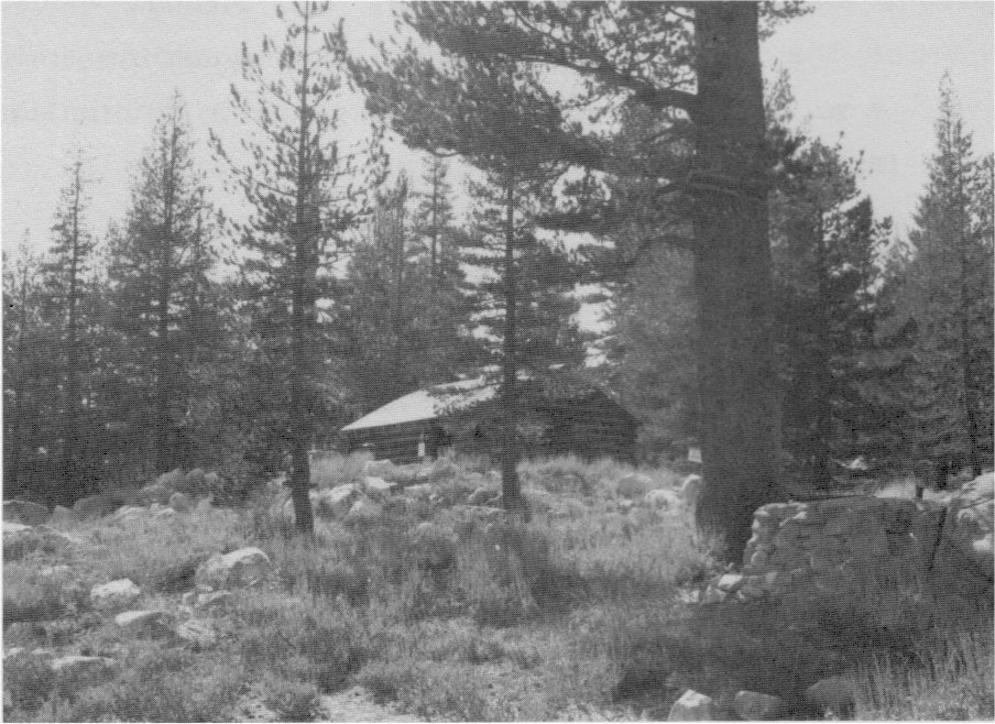
[click to enlarge] |
During this time, there was also activity at Hazel Green. In 1903 a typhoid epidemic struck Palo Alto, California, where the David Currys lived in the winters, and after several family members had been stricken, it was decided to spend a summer recuperating at Hazel Green, which Curry was negotiating to buy from Mrs. Halstead. The purchase was recorded in 1904, although the Curry family had already moved in by 1903. Hazel Green then consisted of one or two log cabins and a white frame house with a wing of bedrooms. The large barn functioned as part of the changing station for stage teams.53
[53. Tresidder, “Reminiscences of Hazel Green.”]
One of the most blatant trespassers on park lands at that time, according to Acting Superintendent Harry Benson, continued to be Senator John B. Curtin of Sonora, who owned about 640 acres of patented lands at Gin, Crane, and Tamarack flats. Although he had carried on considerable correspondence with its administrators since the establishment of the park, Curtin’s problems came to a head during the tenure of Acting Superintendent Benson, whose vigorous enforcement of park regulations resulted in a legal confrontation. Curtin’s flagrant violations of park rules against trespassing had angered park administrators to the point that they prohibited him from driving his stock along the public roads within the park to his property. Curtin then obtained permission to graze several hundred head of cattle in the forest reserve adjoining the park; after being turned loose in that area, the animals immediately headed toward their old grazing grounds near Tamarack, Cascade, and Yosemite creeks, between the Big Oak Flat and Tioga roads, and had consequently been impounded at Wawona.
In response to what he perceived as unfair governmental control, Curtin brought suit in the state courts for a restraining injunction against the acting superintendent to prevent interference with his cattle-grazing operations. He disputed the legality of the Interior Department regulations requiring any person intending to drive stock upon land he claimed within the park to survey it and point out its metes and bounds to the acting superintendent. Curtin also questioned the legality of removing a man’s cattle for failure to comply with that regulation.54
[54. “Yosemite National Park,” in “National Parks and Reservations,” in Annual Reports of the Department of the Interior for the Fiscal Year Ended June 30, 1905, 167; H. C. Benson, “Report of the Acting Superintendent of Yosemite National Park,” 10 October 1905, in ibid., 693-95; H. C. Benson, report of operations in Yosemite National Park during June 1905, in Letters Received by the Office of the Secretary of the Interior Relating to National Parks, 1872-1907 (Yosemite) RG 79, NA, 4.]
The Department of Justice assigned the district attorney for the Northern District of California to take charge of the matter and the case was removed to the U. S. Circuit Court for resolution. Curtin lost the decision in the Circuit Court, but eventually was upheld by the U. S. Supreme Court. The voluminous and acrimonious correspondence between Curtin and park superintendents through the years provides an enlightening picture of the resistance of early Yosemite pioneers and stockmen to government control.
The boundary change of 1905 proved to be only a short-term solution to a growing problem. Completion of the Yosemite Valley Railroad to within a mile of the western park boundary in 1907 made possible the logging of private lands remaining in the park previously considered inaccessible. Additional legislation in later years would be required to protect Yosemite’s scenic features.
It is clear that by the end of the first ten years of army administration of Yosemite National Park, a number of problems still remained to be resolved. All acting superintendents agreed that the implementation of several policies by the federal government, in addition to the acquisition of toll roads, would improve the situation. The policies they suggested included:
1) assignment of more troops to the park so that it could be thoroughly protected;
2) purchase of all private lands within the park limits, so that owners and lessees of patented lands could not allow their sheep and cattle to roam the entire park;
3) formulation of a system of severe penalties for trespass by herders, hunters, and other violators of the park rules. The only penalties in use entailed dispersement of herds, detention of pack trains and camp equipage and stock, and forceful ejection of owners and herders from the park. The superintendent recommended that some officer connected with administration of the park be given the same powers as those enjoyed by U. S. commissioners.
4) establishment of a military camp within Yosemite Valley—a more central and convenient point from which to patrol;
5) erection of a permanent camp in the vicinity of Wawona, with a stable, mess house and kitchen, and library, enabling a detail of men to remain in the park and protect it during the winter months after the bulk of the troops had withdrawn;
6) proper surveying and marking of the park boundary so that patrols and civilians alike could recognize the reservation limits, thereby avoiding much of the ill feeling that arose when people were accused of trespassing; and,
7) a reversal of government policy relative to fire control. Army administrators believed that instead of preventing and suppressing fires, they should be initiating a systematic burning of the forests.55
[55. As early as 1898, however, civilian Acting Superintendent J. W. Zevely stated:
In the matter of the prevention of forest fires; from conversations had with old mountaineers, men who have lived in the Sierras since the fifties, who have been constant observers of the conditions there, and who are deeply interested in the preservation of the forests in the National Parks as well as the National Reservations, I have concluded that the policy heretofore pursued by the Government looking to the prevention of fires altogether, is erroneous. Since the Yosemite Park was established, great efforts have been made by each Superintendent to prevent fires altogether, and when they have started, to prevent their spread. The consequence of this is that the floors of the mountains and the valleys have become covered by decaying pine needles and cones and the leaves of the deciduous trees to a depth of from twelve to eighteen inches; in addition, many trees have fallen and are now decaying, and the whole mass is highly inflammable. The consequence is that when fires start under existing conditions, it is next to impossible to control them at all, and the trees in the track of a fire are destroyed. Prior to the inauguration of the present policy, fires occurred almost every year in all parts of the forests; in fact, they were frequently set by the Indians, but there was so little accumulation on the ground that they were in a great measure harmless, and did not, in any sense, retard the growth of the forest.
I therefore think it would be well to consider whether or not the policy of the Government had not better be reversed, and instead of efforts to prevent fires, a systematic burning had not better be indulged. There is not to be found now in the whole forest any tree of great magnitude which has not upon it the marks of fire, yet the trees have in no wise been seriously affected by these burnings.
Major John Bigelow, Jr., in 1904 also recommended regular and systematic burning of the underbrush and other debris, a procedure recommended by Major Hein in 1902 and approved by Colonel Garrard in 1903. See J. W. Zevely “Report of the Acting Superintendent of the Yosemite National Park for the Year 1898,” in Letters Received by the Office of the Secretary of the Interior Relating to National Parks, 1872-1907 (Yosemite), 5-6, and John Bigelow, Jr., “Report of the Acting Superintendent of Yosemite National Park,” 1904, 382. ]
Other problems existed in addition to those related specifically to national park administration. The army’s job had often been made more difficult because of the split administration of the region between the state, controlling Yosemite Valley and the Mariposa Grove, and the army. Not only were the valley and grove thirty-five miles apart, but after 1890 the valley became a park within a park. For years acting superintendents, environmental groups, the state press, and other influential bodies, as well as a large portion of the general public of California, had expressed themselves as being in favor of the recession of the Yosemite Grant to the federal government. The Sierra Club pointed out that the state of California simply could not afford to appropriate a sufficient amount of money to adequately care for the area. Other necessities in the state would always limit the amount that could be expended on valley improvements. Even though state pride might argue against the changeover, the club believed that the time had come to acknowledge that only the federal government could afford the financial burden of care and development required. Terminating the trust would eventually render the valley and grove more accessible and more enjoyable to visit.56
[56. “Statement Concerning the Proposed Recession of Yosemite Valley and Mariposa Big Tree Grove by the State of California to the United States,” in Sierra Club Bulletin 5, no. 3 (January 1905): 242-47.]
From the War and Interior department viewpoints, such an action would allow the establishment of a suitable post for the army troops, the adoption of a comprehensive system of patrols, the protection of the valley and surrounding areas against fire, the construction of an adequate system of free public roads into the valley, the erection of ample hotel and other visitor accommodations, the prevention of rate abuse by concessioners, and would generally facilitate the administration and protection of the park and ensure the valley’s proper preservation and accessibility. Those favoring recession of the grant believed that the valley and its surroundings logically formed one administrative unit and that the unsuccessful anomaly of dual ownership and divided responsibility should not be allowed to continue. Members of the state legislature and others who had certain vested interests in the valley that might lapse if the federal government assumed control, such as stage lines and hotels, violently opposed the recession. The Southern Pacific Railroad, meanwhile, under the guidance of New York financier E. H. Harriman, secretly threw its weight behind the recession movement. The San Francisco Examiner and State Senator John Curtin led the opposition, calling on state pride in an attempt to prevent this action.
In 1903 President Theodore Roosevelt visited Yosemite and, desiring to view the park as thoroughly as possible, accompanied John Muir into the backcountry for two days and three nights. The pair camped in the Mariposa Grove, at Sentinel Dome, and in the meadows near Bridalveil Fall, where a plaque was later erected commemorating their exchanges around the campfires. The strong-minded Muir had no qualms in passing along his firm convictions on the subject of preserving unspoiled places, in suggesting specific areas that should be saved, and in suggesting necessary legislation to carry out that goal. Despite the disapproval of the valley folk, who were thwarted in their plans for large celebrations in the President’s honor, the discussions between Muir and Roosevelt centering around conservation and despoliation of the forests undoubtedly hastened action on the recession of Yosemite Valley and the Mariposa Grove and influenced Roosevelt to launch an aggressive conservation policy that resulted in the setting aside of large tracts of land in national forest preserves, monuments, and parks.
The urgings of the pro-recession advocates finally culminated in the passage of an act by the California legislature, approved by the governor 3 March 1905, retroceding to the United States the Yosemite Valley and the Mariposa Grove of Big Trees for national park purposes. The act made the recession of the lands in question conditional upon their being formally accepted by the federal government. That provision, included at the request of those who opposed the recession, later served to impede the transfer after the bill had passed.
Illustration 55.
EXHIBIT “C”
MAJOR CHANGES TO BOUNDARIES
YOSEMITE NATIONAL PARK
1864 - 1979
| — • • — | Act of June 30, 1864, authorizing grant to State of California of the “Yosemite Valley” and land embracing the “Mariposa Big Tree Grove.” Signed by President Abraham Lincoln. Also the Act of June 2, 1920, accepting cession by California of exclusive jurisdiction of lands embraced within Yosemite. |
| • • • • • • | Act to set apart certain tracts of land within the State of California as national Forest Reservations. Approved October 1, 1890, and signed by President Harrison. |
| — — — — | Act to exclude certain lands from the Forest Reservation and to attach and include the said lands in the Sierra Forest Reserve. Approved February 7, 1905. Lands hereafter known as Yosemite National Park. |
|
|
Joint Resolution, approved June 11, 1906. Areas subtracted from the Park. |
|
|
Land and timber exchange authorized by Act of Congress. Approved April 16, 1914. |
|
|
Presidential Proclamation of April 14, 1930, signed by President Hoover for the preservation of timber stands along western boundary. The “Rockefeller Purchase.” |
|
|
Proclamation of August 13, 1932, signed by President Hoover, The “Wawona Addition.” |
|
|
Act of July 9, 1937, authorizing the Secretary of Interior to purchase lands in the “Carl Inn Addition,” signed by President F. D. Roosevelt. |
| * | Proposed Crocker Ridge Addition: 253 acres of U. S. Department of Agriculture, Stanislaus National Forest land to be included within the Yosemite boundary. Proposed Mt. Raymond transfer: 160 acres of Park land to be transferred to U. S. Department of Agriculture, Sierra National Forest. |
From Yosemite Draft Land Acquisition Plan, 1979
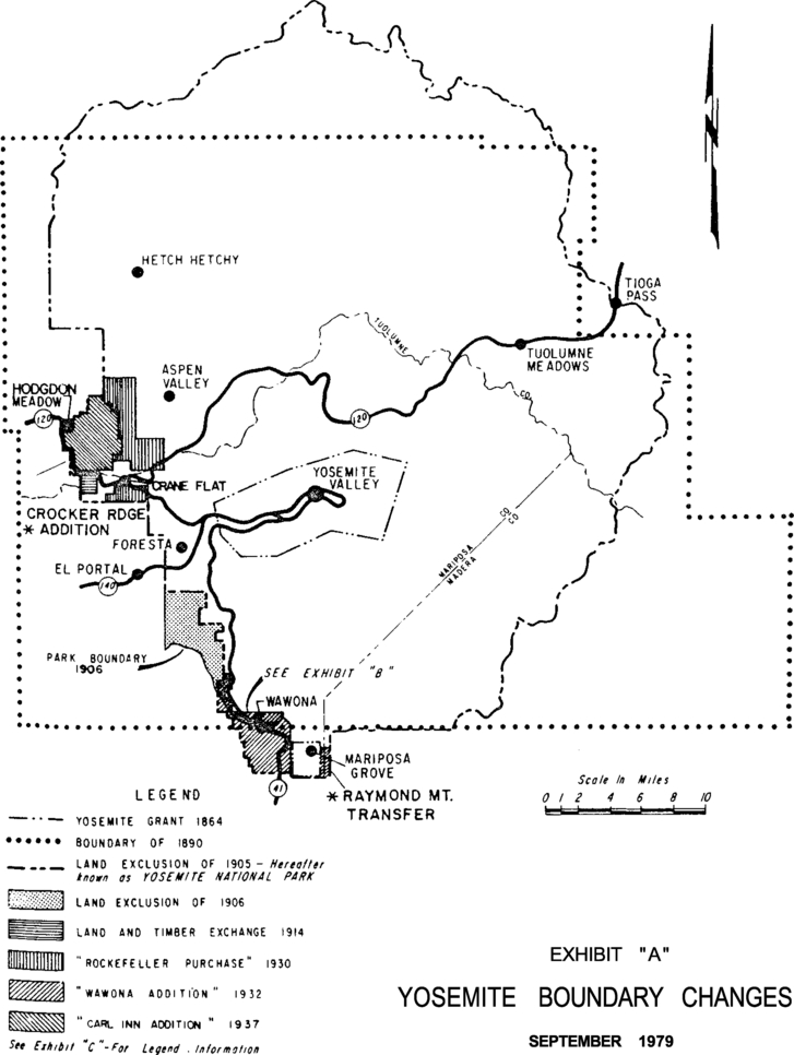
[click to enlarge] |
With prior knowledge of the legislation pending in the California legislature, the Department of the Interior contacted the chairman of the Committee on Appropriations of the Senate on 1 March 1905, calling attention to the bill’s provisions. At the same time the department suggested incorporating in the Sundry Civil Bill acceptance of the retrocession, making the lands part of Yosemite National Park and appropriating money for their management and protection. The suggested legislation was incorporated in the Sundry Civil Bill, acted upon favorably by the Senate, rejected in the House, sent to conference, and finally eliminated from the bill.
Immediately after the governor of California approved the act of the state legislature, the information was telegraphed to Washington. Senator George C. Perkins of California immediately introduced a bill in the Senate providing for the acceptance of the recession and for a suitable appropriation for the care of Yosemite Valley, which immediately passed. It then went to the House, where attention was called to the fact that the rules forbade the introduction of new legislation on the last day of Congress. Members of Congress then agreed that a joint resolution should be prepared to obviate the difficulty. That resolution passed the Senate and later the House in an amended form. Public Resolution No. 29, 3 March 1905, carried the title “Joint Resolution Accepting the recession by the State of California of the Yosemite Valley Grant and the Mariposa Big Tree Grove in the Yosemite National Park.”
At that point, the Secretary of the Interior and the military authorities requested permission of the state to establish a military camp in the valley, that being a more central location from which to send out patrols and obtain supplies. The secretary also requested the governor to turn over the state property in the valley to the acting superintendent of Yosemite National Park as the legal representative of the Interior Department. When the military superintendent, after consultation with Governor George Pardee, proceeded to the valley to select a suitable camp location, however, the Yosemite commissioners informed him that they did not recognize his right to establish a camp of his choice. Instead, treating the troops as they would any other campers, they asked the Guardian to locate the campsite. Because the area designated for their camp was a small meadow, unsuitable for a detachment of that size, Benson decided not to quarter troops in the valley during the 1905 season.
The state commissioners opposed to the recession refused to cooperate in any way with federal authorities. They declined to surrender the state’s property, arguing that the valley had been entrusted to their care by the state and that, in their opinion, the federal government had not formally accepted the recession as specified under the state act. They then turned the matter over to the state attorney-general for opinion. Although it seemed clearly the intention of Congress to accept the recession of Yosemite Valley and the Mariposa Big Tree Grove, the bill prepared by the Department of the Interior, as amended and passed into law, provided only an appropriation for the care of Yosemite National Park. It contained no specific acceptance of the cession by Congress.
The Interior Department noted, however, that the original act ceded the valley to the state only in trust and that the state, tired of the responsibility, had determined to abandon it and had passed a resolution to that effect, which the governor had approved. Neither the state legislature nor the governor opposed turning over state property on the grounds that the federal government had not accepted the recession. That argument had instead been initiated by a body that the state legislature had created and that had, in fact, by the act of recession, been legislated out of office. The Yosemite commissioners, however, managed by such delaying tactics to retain possession of state property in the valley and the grove and prevent its use by the federal government in the administration of the reservation.
The joint resolution of 3 March 1905 appropriated twenty thousand dollars for the management, improvement, and protection of Yosemite National Park. The question then arose as to the propriety of expending part of that appropriation in improvements in the valley and grove, which were still being held as state property. The Comptroller of the Treasury held that the sum appropriated by the resolution was intended to be used for that purpose. Because of the problems posed by the stubbornness of the state commissioners, however, the Department of the Interior declined to spend any of the sum on either area.
Obviously something had to be done to resolve this continuing problem of dual ownership. At the insistence of Senator Perkins, a draft joint resolution was prepared that he introduced in the Senate on 19 December 1905 as Senate Joint Resolution 14, entitled “Joint Resolution Accepting the recession by the State of California of the Yosemite Valley Grant and the Mariposa Big Tree Grove, and including the same, together with fractional sections five and six, township five south, range twenty-two east, Mount Diablo meridian, California, within the metes and bounds of the Yosemite National Park.” (For administrative purposes in the management of the Mariposa Big Tree Grove, a parcel of land approximately one mile long and two miles wide, immediately south of the park and abutting the grove on the north, was included within the metes and bounds of the park.)
On 15 January 1906, California Congressman J. N. Gillett introduced the same form of resolution in the House as Joint Resolution 77. Further complicating matters, an amendment was proposed to Senate Joint Resolution 14 relative to further elimination of lands from the southwestern portion of the park.
A group of San Joaquin Valley businessmen, backed by the Southern Pacific Railroad, had formed the Fresno Traction Company in 1903 in hopes of building a line from Fresno to Wawona to compete with the Yosemite Valley Railroad. The Fresno Traction Company in 1906, during the discussion on the joint resolution accepting the recession, urged congressional members to amend the bill to eliminate a strip of land on the southwest from the park to enable the company to secure a right-of-way for its electric railroad. That proposed line would approach Yosemite Valley via Wawona, carrying passengers, baggage, and freight, but not conveying timber, lumber, or like materials cut within the park or nearer to it than Wawona without permission of the Secretary of the Interior. The company also stated it would purchase at least twenty-five thousand dollars worth of patented timberlands along the route, subject to an option of the government to purchase, and construct a wagon road from the line’s terminus connecting with the road system into the valley. Private parties and the acting superintendent opposed that amendment, which the Department of the Interior considered detrimental to the park’s welfare. A hearing on the subject was held at the department. Because the acreage proposed for elimination from the park and placement in the Sierra Forest * Reserve was too large, a substitute amendment was suggested. It permitted construction of a railroad from the south under conditions not materially affecting the integrity of the park or necessitating elimination of such a large acreage of valuable forest land.
Accordingly a new bill was prepared embodying the substitute amendment. Introduced in the House as Joint Resolution 118 and reported on favorably by the appropriate House and Senate committees, the bill as amended passed the House and Senate and President Roosevelt signed it under date of 11 June 1906. The resolution changed the park boundaries by excluding 13.06 square miles and adding about 54 square miles, making a total area of about 1,124 square miles. The new boundaries followed surveyed lines on the west and southwest because of existing private claims, but on the north, east, and south followed natural lines—either divides between watersheds or large stream channels.
On 15 June 1906, the acting superintendent was directed to establish his camp in the Yosemite Valley and take charge of the latter as well as the grove. The Interior Department telegraphed Governor Pardee to advise the Yosemite Valley commission of the approval of the bill accepting the recession and to direct the Guardian to complete his work and turn over state property to Major Benson.
The commissioners remained in charge of the valley and grove until 1 August 1906, at which time the state formally surrendered the reservation to the acting superintendent, as well as the electric plant in the valley. Personal property, such as horses, wagons, tools, and implements, was stored with private parties in the valley pending its appraisal and transfer to the federal government.57
[57. Report on Yosemite National Park under “National Parks and Reservations,” 172-75, and Benson, “Report of the Acting Superintendent of Yosemite National Park,” 10 October 1905, in Annual Reports of the Department of the Interior for the Fiscal Year Ended June 30, 1905, 691-92; and report on Yosemite National Park, under “National Parks and Reservations,” 197-200, and H. C. Benson, Major, Fourteenth Cavalry, “Report of the Acting Superintendent of Yosemite National Park,” 30 September 1906, in Annual Reports of the Department of the Interior for the Fiscal Year Ended June 30, 1906. Report of the Secretary of the Interior and Bureau Officers, Etc. (Washington: Government Printing Office, 1906), 649-52. All fixtures in the valley were transferred to the federal government under a transfer act passed by the California legislature. Portable property was appraised and bought by Major Benson for $1,750.]
Prior to the recession of the Yosemite Valley and Mariposa Grove to the United States, Yosemite National Park had been administered more as a forest reservation or “wilderness park.” Although it had posed a tremendous number of complex problems, acting superintendents had not been concerned with most of the problems generated by tourism, such as adequate visitor accommodations, safety measures, transportation services, rate regulation, grocery and feed services, and the like. With the transfer of administrative headquarters from Wawona to the valley, however, acting superintendents of necessity became much more involved in immediate and complex pressures. In addition to concerns over private landownership, poaching, and trespassing, they became embroiled in questions of improved road systems; water, sewer, and electrical requirements; the need for better communication and administrative facilities; and regulation of a growing concession industry.
Next: 4: Cavalry 1905-1915 • Contents • Previous: 2: State Grant 1864-1890
| Online Library: | Title | Author | California | Geology | History | Indians | Muir | Mountaineering | Nature | Management |
http://www.yosemite.ca.us/library/yosemite_resources/early_cavalry_years.html