The following data comprises a backcountry survey conducted by the
Hoods in the late 1950s and early 1960s. Many of the structures are no
longer standing. The Hoods concentrated primarily on roads, trails, and
various structures and did not note such resources as blazes, logging
camps, or railroad grades. The survey does, however, provide useful
information on properties with visible remains ca. 1964. (The spelling
and abbreviations of the original document have been retained for the
most part.)
Map
No. |
Location |
Name of Site |
| 1 |
A-4 |
Cabin, Lake Vernon (T. Reid) |
| 2 |
A-5 |
Cabin, Jack Main Canyon, 1 mile south of Bearup Lake |
| 3 |
A-5 |
Cabin, Tiltill Mountain |
| 4 |
B-3 |
Cabin, Cherry Valley (Lord’s, Homestead F. E. Morelos) |
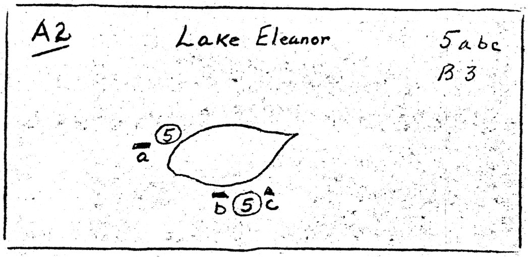
| 5 a |
B-3 |
Cabin, North Shore Lake Eleanor (Kibbie) |
| b |
B-3 |
Cabin, South Shore Lake Eleanor (Homestead Wolfe) |
| c |
B-3 |
Patrol Post, Lake Eleanor |
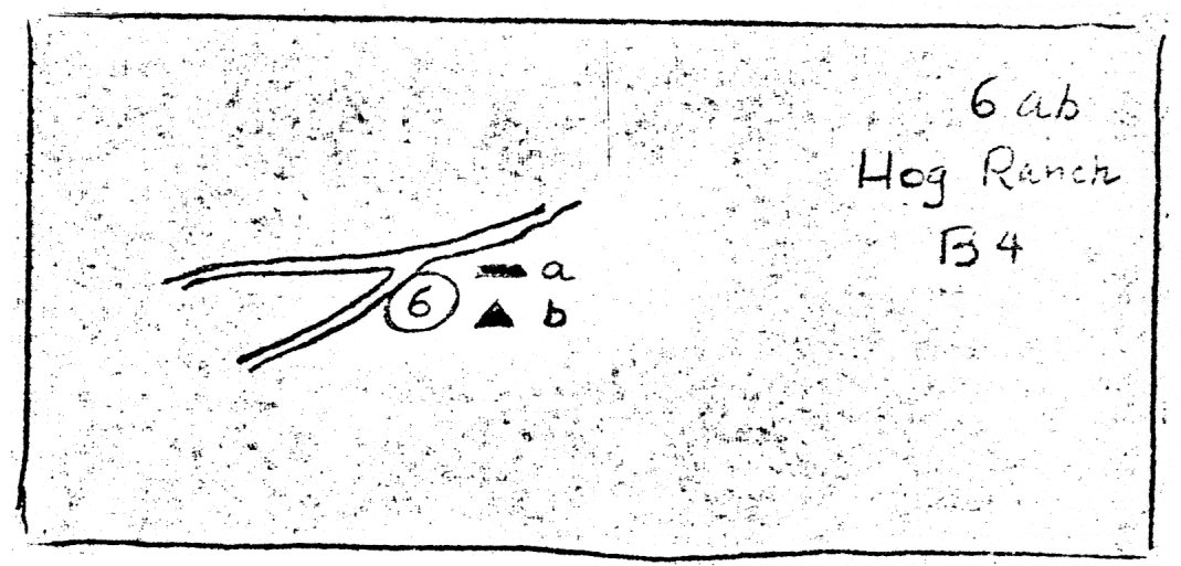
| 6 a |
B-4 |
Cabin, Hog Ranch (Homestead C. Smith) |
| b |
B-4 |
Patrol Post, Hog Ranch |
| 7 |
B-4 |
Cabin, Miguel Meadows (M Herrera Homestead R. Jones) |
| 8 |
B-4 |
Cabin, Poopenaut Valley (Homestead, Marshner) |
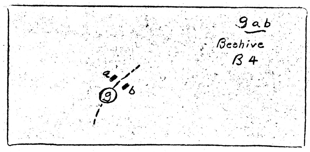
| 9 a |
B-4 |
Cabin, Beehive |
| b |
B-4 |
Cabin, Beehive |
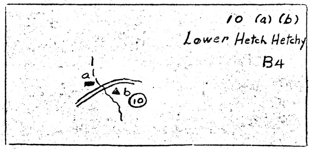
| 10 a |
B-4 |
Cabin, Lower Hetch-Hetchy (Homestead J. Screech) |
| b |
B-4 |
Cabin, Patrol Post, Hetch Hetchy |
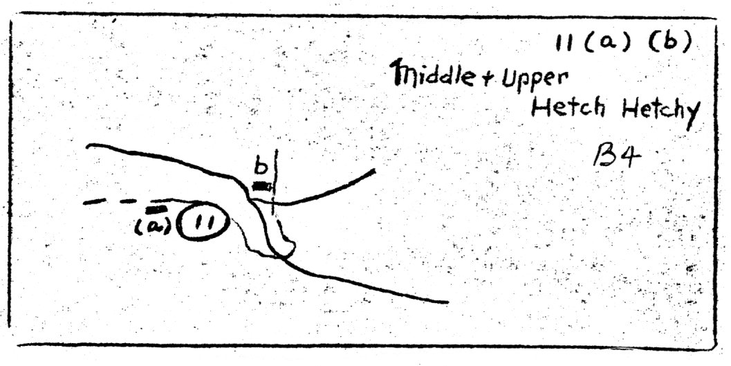
| 11 a |
B-4 |
Cabin, Middle Hetch Hetchy (Homestead N. Screech) |
| b |
B-4 |
Cabin, Upper Hetch Hetchy (Homestead H. & E. Kallett) |
| 12 |
B-4 |
Cabin, Smith Meadows or Milk Ranch (C. Smith) |
| 13 |
B-4 |
Cabin, Mt. Gibson |
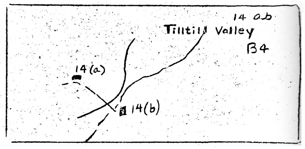
| 14 a |
B-4 |
Cabin, Tiltill Valley (Homestead E. Elwell) |
| b |
B-4 |
Cabin, Tiltill Valley |
| 15 |
B-4 |
Cabin, Harden Lake |
| 16 |
B-5 |
Cabin, White Wolf (Homestead J. Ridley) |
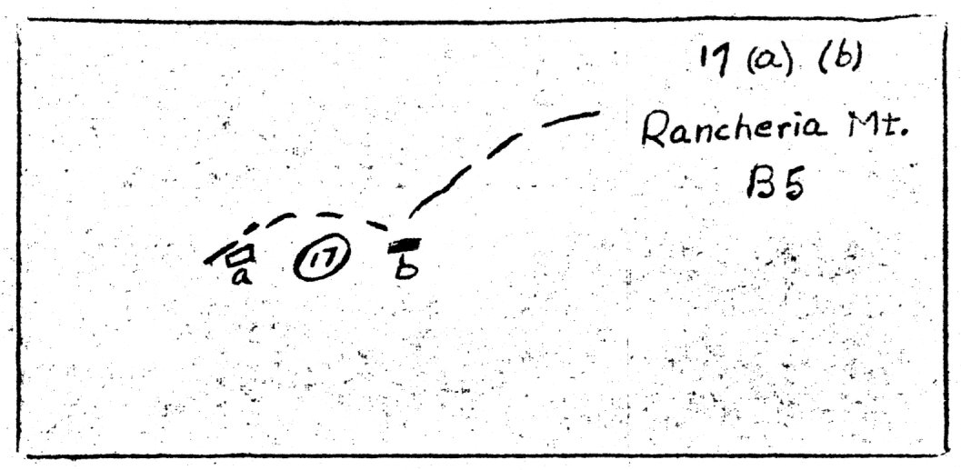
| 17 a |
B-5 |
Corral, Rancheria Mt. |
| b |
B-5 |
Cabin, Rancheria Mt. |
| 18 a |
B-6 |
Cabin, miner’s, Snow Flat |
| b |
B-6 |
Cabin, miner’s, Snow Flat |
| 19 |
B-6 |
Historical Site, Mariposa Battalion at Lake Tenaya Capture 35 Indians |
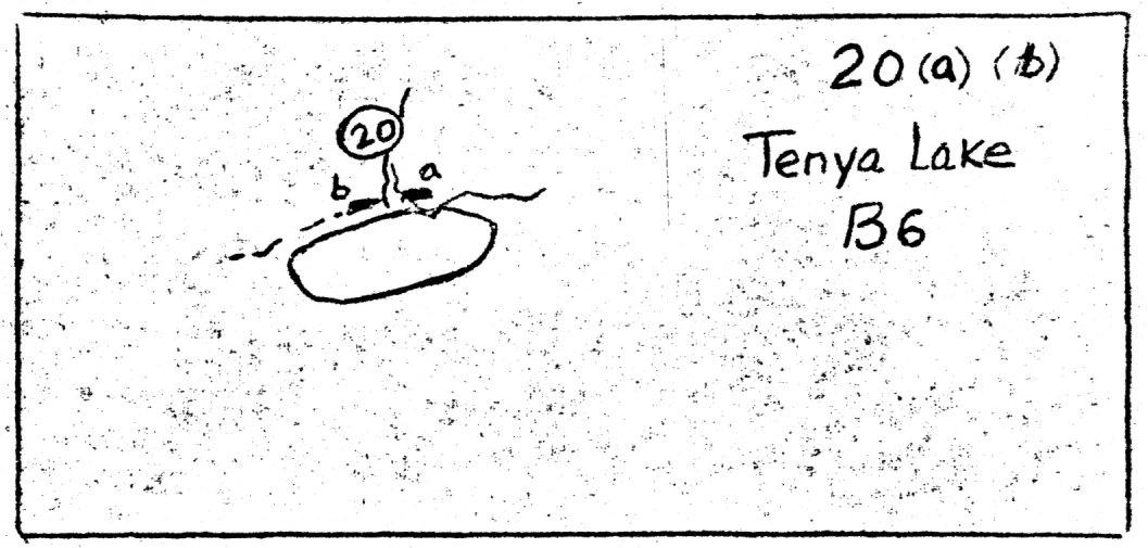
| 20 a |
B-6 |
Cabin, Tenaya Lake (J. Murphy) |
| b |
B-6 |
Cabin, Tenaya Lake (J. Murphy) |
| 21 |
B-6 |
Cabin, Tenaya Lake east end |
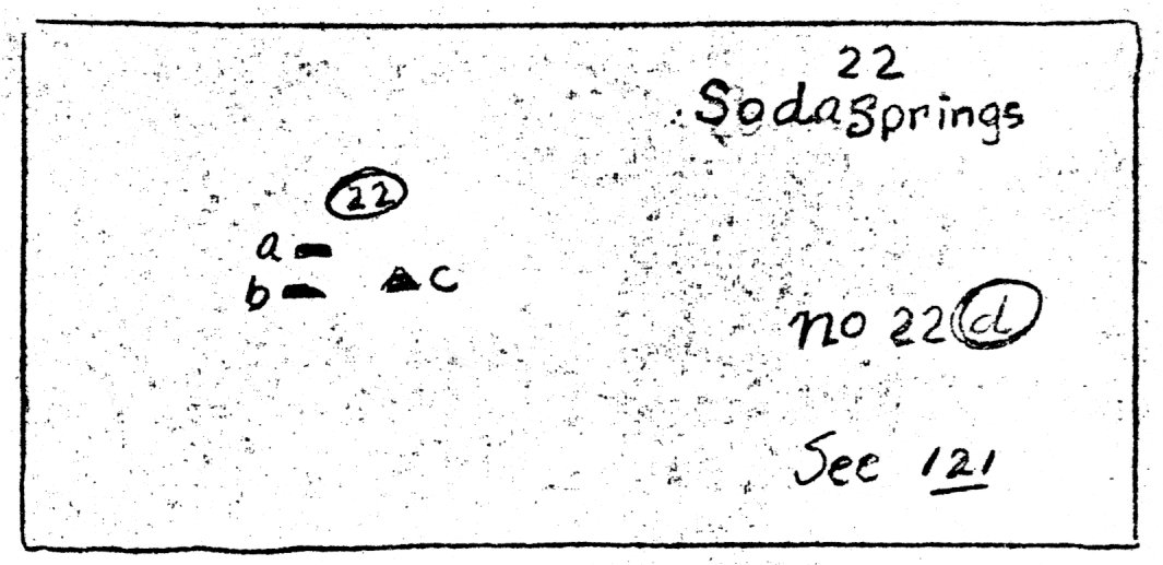
| 22 a |
B-6 |
Cabin, Soda Springs (J. B. Lembert) |
| b |
B-6 |
Cabin, Soda Springs (J. McCauley) |
| c |
B-6 |
Patrol Post, Soda Springs |
| 23 |
B-6 |
Cabin, Junction of Tioga Rd. and Lyell Creek Tr. |
| 24 |
B-6 |
Cabin, Elizabeth Lake Tr. |
| 25 |
B-7 |
Cabin, Lower Dana Meadows |
| 26 |
B-7 |
Cabins (7), Tioga Mines |
| 27 |
B-7 |
Cabin, Great Sierra Mines, U. Gaylor Lakes |
| 28 |
B-7 |
Cabin, Upper Dana Meadows |
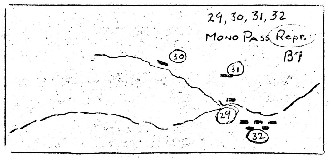
| 29 |
B-7 |
Cabin, Upper Mono P. Trail |
| 30 |
B-7 |
Cabin, Lower Mono P. Trail |
| 31 |
B-7 |
Cabin, Mt. Gibbs (Gus Corde) |
| 32 |
B-7 |
Cabins (5), Mono Pass (Ella Bloss) |
|
33 |
B-7 |
Cabins (2), Avalanche, Mt. Gibbs |
| 34 |
C-1 |
Settlement, Big Oak Flat |
| 35 |
C-1 |
Settlement, Groveland, 1st Garrotte |
| 36 |
C-1 |
Settlement, Coulterville |
| 37 |
C-2 |
Hotel, Bower Cave |
| 38 |
C-3 |
Ranch, Bull Creek (Black’s) |
| 39 |
C-3 |
Ranch, Harden’s |
| 40 |
C-3 |
Hotel, Crocker’s Station |
| 41 |
C-3 |
Cabin, Coulterville Road (Henry Rose) |
| 42 |
C-3 |
Cabin, Hazel Green (Homestead James Halstead) |
| 43 |
C-3 |
Ranch and Stage Station (Hodgdon’s) (5 structures) |
| 44 |
C-4 |
Patrol Post, Merced Grove |
| 45 |
C-4 |
Cabin, 2 miles west of Aspen Valley |
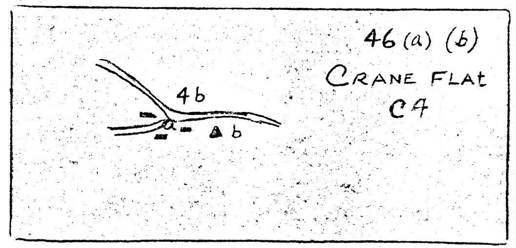
| 46 a |
C-4 |
Cabins, Crane Flat (Homesteads, James Martin, Ann Gabin) |
| b |
C-4 |
Patrol Post, Crane Flat |
| 47 a |
C-4 |
Cabin, El Portal (J. B. Lembert, Homestead Wharton) |
| b |
C-4 |
Cabin, El Portal, south side of river |
| 48 |
C-4 |
Ranch, McCauley’s near Big Meadow (2 structures) |
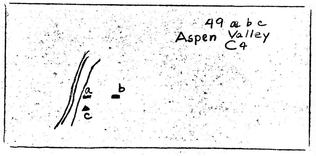
| 49 a |
C-4 |
Cabin, Aspen Meadows (Hodgdon’s summer) |
| b |
C-4 |
Cabin, (Babcock’s Cache) |
| c |
C-4 |
Patrol Post, Aspen Meadows |
| 50 |
C-4 |
Cabin, Gin Flat (J. Curtin) |
| 51 a |
C-4 |
Stage Station, Tamarack Flat (Homestead David Woods) |
| b |
C-4 |
Lodge and Store, Tamarack Flat |
| 52 |
C-4 |
Historical Site, “Standpoint of Silence” |
| 53 a |
C-4 |
Cabin, Big Meadow (Anderson’s) |
| b |
C-4 |
Cabin, Big Meadow (Meyer’s) |
| c |
C-4 |
Cabin, Big Meadow (Rutherford’s) |
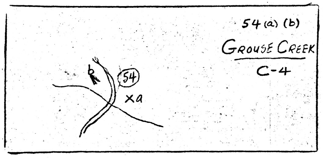
| 54 a |
C-4 |
Historical Site, Mariposa Battalion met 72 Indians |
| b |
C-4 |
Stage Station, Grouse Creek (The Hermitage) |
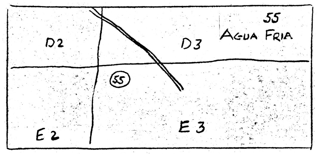
| 55 |
E-3 |
Settlement, Agua Fria, Mariposa Battalion enlisted here |
| 56 |
C-5 |
Cabin, McGurk Meadow |
| 57 |
C-5 |
Cabin, Bridalveil Meadows (Westfall’s)
Hotel Same Site (Peregoys Mountain View House)
|
| 58 |
C-5 |
Cabin, Bridalveil Meadows (Ostrander’s) |
| 59 |
C-5 |
Cabin, Mono Meadow (Milt Egan’s) |
| 60 |
D-2 |
Settlement, Bear Valley (Fremont’s Headquarters) |
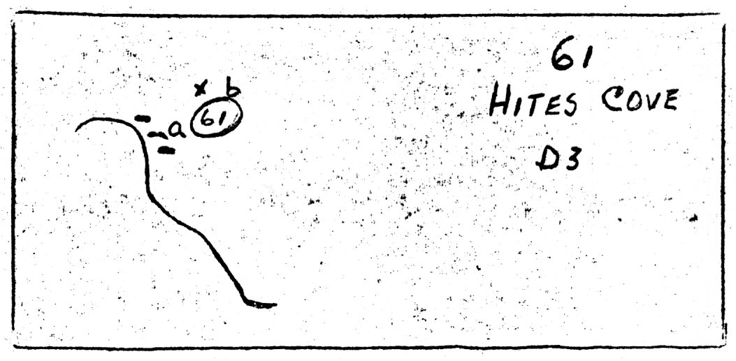
| 61 a |
D-3 |
Cabins, Hite’s Cove |
| b |
D-3 |
Mine, Hite’s Cove |
| 62 a |
C-4 |
Ranch (Henness) |
| b |
C-4 |
Cabin, North of Merced River near Henness Ranch |
| 63 |
D-4 |
Historical Site, Indian Ranchero captured by Mar. Bat. |
| 64 |
D-4 |
Historical Site, Bishop’s Camp, occupied by Mar. Bat. |
| 65 |
D-4 |
Stage Station, Chinquapin (2 structures) |
| 66 |
D-4 |
Stage Station, 11 mile (Homestead West Woods) (2 structures) |
| 67 |
D-4 |
Stage Station, 8 mile (2 structures) |
| 68 |
D-4 |
Cabin, Alder Creek |
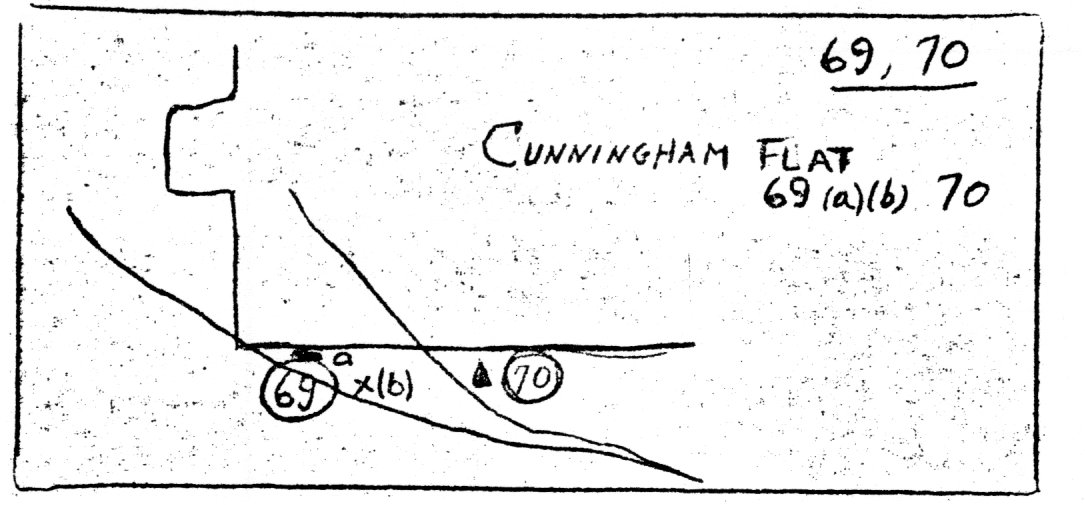
| 69 a |
D-4 |
Cabin, Cunningham Flat (Cunningham’s) |
| b |
D-4 |
Historical Site, Campground Mariposa Battalion |
|
70 |
D-5 |
Camp A. E. Wood, Camp Hoyle later on same site |
| 71 |
D-5 |
Hotel and Settlement, Wawona |
| 72 |
D-5 |
Cabin, Crescent Lake (Jim Duncan) |
| 73 |
|
|
| 74 |
D-5 |
Cabin, Johnson Lake (Homestead Acosta) |
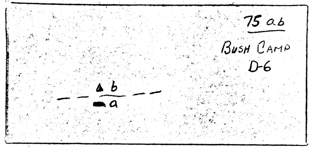
| 75 a |
D-6 |
Cabin, Buck Camp |
| b |
D-6 |
Patrol Post, Buck Camp |
| 76 |
D-8 |
Cabin, Devil Post Pile |
| 77 |
E-3 |
Settlement, Mariposa |
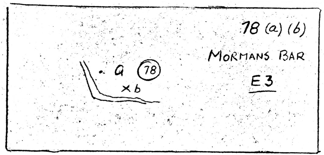
| 78 a |
E-3 |
Settlement, Mormon Bar |
| b |
E-3 |
Historical Site, Campsite of Mariposa Battalion |
| 79 |
E-4 |
Historical Site, Campsite of Mariposa Battalion |
| 80 |
D-4 |
Cabin (P. R. Gibson’s) |
| 81 |
E-5 |
Patrol Post, Lower Mariposa Grove |
| 82 |
D-5 |
Cabin, Upper Mariposa Grove |
| 83 |
D-5 |
Cabins, Biledo Meadow (2 structures) |
| 84 |
C-1 |
Settlement, 2nd Garrotte |
| 85 |
C-2 |
Ranch (Sprague’s) |
| 86 |
C-2 |
Flume, Golden Rock |
| 87 |
C-2 |
Ranch (Hamilton’s) |
| 88 |
C-3 |
Ranch, Colfax Springs (Elwell’s) |
| 89 |
C-2 |
Cabin, Deer Flat |
| 90 |
C-3 |
Cabin, Jenkin’s Mill |
| 91 |
C-3 |
Cabin, Big Grizzly Flat (Homestead S. Varain) |
| 92 |
C-4 |
Historical Site, Buena Vista Gap, 1st View of Yosemite |
| 93 |
C-5 |
Historical Site, Army Target Range |
| 94 |
C-5 |
Cabin, Last Water (Anderson’s) |
| 95 |
C-6 |
Cabin, Hopkins Meadow |
| 96 |
E-3 |
Settlement, Bridgeport |
| 97 |
E-4 |
Hotel, Lard’s - later Hogan’s |
| 98 |
D-5 |
Cabin, Empire Meadow |
| 99 |
D-5 |
Cabin (Westfall’s) |
| 100 |
D-5 |
Cabin (Sussman’s) |
| 101 |
D-5 |
Cabin, Turner Meadows |
| 102 |
D-3 |
Sawmill, Clark and Cook’s |
| 103 |
D-3 |
Sawmill, Snyder Gulch |
| 104 |
E-4 |
Historical Site, Stage Holdup |
| 105 |
C-3 |
Cabin, Anderson Flat |
| 106 |
D-4 |
Cabin, Bear Wallow near Devil Pk (Homestead C. H. Murphy) |
| 107 |
A-5 |
Corral, Benson Lake |
| 108 |
C-3 |
Stage Station, Coulterville Road (3 structures |
| 109 |
B-3 |
Cabin, 2 miles southwest of Hog Ranch |
| 110 |
B-3 |
Cabin, 1 mile north of Ackerson Meadow on Hog Ranch Road |
| 111 |
B-3 |
Cabin, Ackerson Meadow |
| 112 |
B-3 |
Cabin, 1 mile southwest of Hog Ranch |
| 113 |
B-7 |
Cabin, Walker Lake (Chumbeau’s) |
| 114 |
C-3 |
Stage Station, Carlin Meadow |
| 115 |
B-4 |
Cabin, 2 miles east of Hog Ranch on Hetch Hetchy Road |
| 116 |
C-5 |
Cabin, Porcupine Flat on Tioga Road |
|
117 |
B-3 |
Ranch (Drew’s) |
| 118 |
E-4 |
Cabin (De Long’s) |
| 119 a |
E-4 |
Hotel (White and Hatch’s) |
| b |
E-4 |
Sawmill (White and Hatch’s) |
| 120 |
E-4 |
Cabin (Thompson’s) |
| 121 |
B-6 |
Cabin and Corral, foot of Cathedral Trail, Tuolumne Meadows |
| 122 |
E-3 |
Cabins (Sebastapol) |
| 123 |
E-4 |
Cabins, Cold Spring’s (Conway’s) (2 structures) |
| 124 |
D-4 |
Cabin, on South Fork of Merced River at Mouth of Devils Gulch |
| 125 a |
D-3 |
Settlement, Jerseydale |
| b |
D-3 |
Sawmill, Jerseydale |
| 126 |
C-6 |
Cabin, Little Yosemite |
| 127 |
B-3 |
Cabin on road between Hog Ranch and Drew Ranch |
| 128 |
D-3 |
Savage’s Trading Post |
1. Sonora-Yosemite Telegraph line. First service May 25th, 1872, but
abandoned after 1874. Constructed by H. L. Street.
2. Telegraph Line Berenda—Grants Sulphur Springs—Wawona Yosemite.
Constructed by Western Union 1882.
3. A temporary telephone line from El Portal to Yos. V was installed in
1907 by Yos. Trans Co., Yos Terminal Hotel Co., and Mr. Cook of
Sentinel Hotel to facilitate reservations. Government also used it.
In 1908 Pac. T & T constructed both telephone and telegraph lines
connecting Yosemite with outside world via El Portal and Merced
Canyon.
4. Hetch-Hetchy telephone line installed in 15 days by Capt. Wells of
14th Cavalry with Army equipment in 1908.
5. Branch phone line to L. Eleanor from Hetch-Hetchy, 1909.
6. Branch phone line to Aspen Valley from Tamarack Flat, 1910.
7. Branch phone line to Merced G from Crane Flat, 1909.
8. Early phone line connecting Glacier Pt., Stoneman H Stables,
Guardians of 1891.
9. Branch line to Soda Sp from Valley, 1909. There was an earlier line
in 1883 intended to connect Bodie and Sonora by telegraph, but we
only have record of a phone connection which did not survive the
winter. There is no evidence that the Sonora-Yosemite line was
restored.
10. Lundy-Bennettville telephone line opened for service March 1882 and
closed with the Tioga Mine in 1884.
11. Yosemite-Wawona telephone line Army 1909.
12. Mariposa B. T. branch telephone line Army 1909.
13. Buck Camp branch telephone line Army 1910.
|
|
|
|
|
|
|
Park Roads
|
|
H & G
1868 |
LeConte
1893 |
McClure
1895 |
Mc&Ben
1893 |
1907 |
|
| 1 |
a |
1 |
1 |
1 |
1 |
a) Schlictman shows road reached Hardin
Ranch in ’68. H&G shows road to
Spragues Ranch |
| 2 |
a |
1 |
1 |
1 |
1 |
a) Road only to Black’s on Fall
Creek |
| 3 |
X |
1 |
1 |
1 |
1 |
|
| 4 |
X |
1 |
1 |
1 |
1 |
|
| 5 |
X |
b |
c |
X |
1 |
b,c) Road reaches up to
Rockslide |
| 6 |
X |
X |
e |
d |
e |
c,d,e) From Big Meadow to
McCauley’s R. |
| 7 |
X |
X |
X |
X |
1 |
|
| 8 |
X |
1 b |
1 |
1 |
1 |
b) Shows junction at 11 mile,
probably error. |
| 9 |
a |
1 |
1 |
1 |
1 |
a) Road reached Chowchilla Cr. |
| 10 |
X |
X |
1 |
1 |
1 |
|
| 10a |
X |
1 |
1 |
1 |
1 |
|
| 10b |
X |
1 |
1 |
1 |
1 |
|
Park Trails
|
| 11 |
X |
1 |
1 |
1 |
1 |
|
| 12 |
X |
X |
X |
X |
1 |
|
| 13 |
X |
1 |
1 |
1 |
1 |
|
| 14 |
X |
X |
1 |
1 |
1 |
|
| 15 |
X |
1 |
1 |
1 |
1 |
|
| 16 |
X |
X |
1 |
1 |
1 |
|
| 17 |
X |
1 |
1 |
1 |
1 |
|
| 18 |
1 |
1 |
1 |
1 |
1 |
|
| 19 |
X |
1 |
1 c |
1 |
1 |
c) Dim |
|
20 |
X |
X |
X |
X |
1 |
|
| 21 |
X |
X |
1 |
1 |
1 |
|
| 22 |
X |
|
1 |
1 |
1 |
|
| 23 |
X |
X |
1 |
1 d |
1 |
c) Dim trail from Pleasant V into
Morrick C via the Sink |
| 24 |
X |
X |
1 |
1 |
1 |
|
| 25 |
X |
X |
1 |
1 |
1 |
|
| 26 |
X |
X |
1 |
1 |
1 |
|
| 27 |
X |
X |
X |
X |
1 |
|
| 28 |
X |
X |
1 |
X d |
1 |
d) A rough trail goes up Matterhorn
Canyon and over into and down
Spiller Canyon |
| 29 |
X |
1 |
1 c |
1 |
1 |
c) Dim. |
| 30 |
X |
1 |
1 c |
1 |
1 |
c) Dim. |
| 31 |
X |
1 |
1 |
1 |
1 |
|
| 32 |
X |
X |
1 |
1 |
1 |
|
| 33 |
X |
X |
1 c |
1 d |
X |
c,d) Tamarack Flat to Porcupine Flat
c,d) Tuolumne Meadows to Walker L |
| 34 |
1 |
b |
c |
d |
e |
Superseded by road |
| 35 |
1 |
1 |
1 |
1 |
X |
|
| 36 |
1 |
b |
c |
d |
e |
Superseded by road |
| 37 |
1 |
X |
1 |
X |
X |
|
| 38 |
a |
X |
1 |
1 |
1 |
a) Short trail to Milk Ranch from
Hetch-Hetchy Trail |
| 39 |
X |
X |
1 |
1 |
1 |
|
| 40 |
X |
X |
1 |
1 |
1 |
|
| 41 |
X |
X |
1 |
1 |
1 |
|
| 42 |
X |
X |
1 |
1 |
1 |
|
| 43 |
X |
X |
1 c |
1 d |
1 |
c,d) Also a branch to Tioga Road
up Cathedral Creek |
| 44 |
1 a |
b |
c |
d |
e |
a) From Blacks at Bull Creek
b,c,d,e) Superseded by road |
|
45 |
X |
X |
1 |
1 |
1 |
|
| 46 |
X |
X |
1 |
1 |
1 |
|
| 47 |
X |
X |
1 c |
1 |
1 e |
c) Dim. e) Hazel Green to
Big Grizzly Flat Only |
| 48 |
X |
1 |
1 |
1 |
e |
e) Superseded by RR Along Merced C |
| 49 |
X |
1 |
1 c |
1 d |
1 e |
c,d,e) El Portal to McCauley’s R |
| 50 |
X |
1 b |
1 c |
1 d |
e |
b,c,d) Up N bank to Coulterville Rd.
foot from
e)Superseded by road |
| 51 |
X |
X |
X |
X |
X |
|
| 52 |
X |
1 |
1 |
1 |
1 |
|
| 53 |
X |
X |
X |
X |
X |
|
| 54 |
X |
X |
X |
X |
X |
|
| 55 |
X |
1 b |
1 c |
1 d |
1 e |
b,d) Front & back from Clouds Rest
c) Front. Dim extension to Tenya L
e) Front |
| 56 |
X |
X |
1 c |
X |
X |
c) Dim to Tenya L - see 55 |
| 57 |
1 |
1 b |
1 |
1 |
1 |
b) Little Yosemite to Tuolumne M |
| 58 |
X |
X |
X |
X |
1 e |
e) Upper Trail |
| 59 |
X |
X |
1 c |
1 d |
1 |
c) Connects w/Mt. Clark Trail
d) Connects w/Isberg Pass Trail |
| 60 |
X |
X |
1 |
1 |
1 |
|
| 61 |
X |
X |
X |
1 |
1 |
|
| 62 |
X |
X |
1 |
1 |
1 |
|
| 63 |
X |
1 b |
1 |
1 |
1 |
b) From 1000 Is L South |
| 64 |
X |
X |
1 |
1 |
1 |
|
| 65 |
X |
X |
1 |
1 |
1 |
|
| 66 |
X |
1 |
1 c |
1 |
1 |
c) High and low trail |
| 67 |
X a |
1 b |
1 c |
1 d |
1 |
a) Hites Cove shown at Junction of
S. Fork with Merced R. (error).
b) Indicated as road Snyders G. to
Merced R.
c,d) Hites Cove to Wards on S. Bank |
|
69 |
X |
X |
1 c |
1 d |
1 |
c,d) Connects with Henness Tr. |
| 70 |
1 |
b |
c |
d |
e |
b,c,d,e) Superseded by road |
| 71 |
X |
X |
X |
X |
X |
Indian Trail followed approx. route
of old Wawona Yosemite Rd. |
| 72 |
1 |
X |
1 |
1 |
1 |
|
| 73 |
1 |
1 b |
1 |
1 |
e |
b)No trail Peregoy Mds. to new
Inspiration Pt.
e)New trail Peregoy Mds. to Old
Inspiration Pt. |
| 74 |
X |
X |
1 |
1 |
1 |
|
| 75 |
X |
X |
X |
X |
1 |
|
| 76 |
X |
X |
1 |
1 |
1 |
|
| 77 |
X |
X |
1 |
1 |
1 |
|
| 78 |
X |
X |
1 |
1 |
1 |
|
| 79 |
X |
X |
1 |
d |
1 |
d) Ends between Mt. Clark & Merced L |
| 80 |
X |
X |
1 |
1 |
1 |
|
| 81 |
X |
X |
1 |
1 |
1 |
|
| 82 |
X |
1 |
1 |
1 |
1 |
|
| 83 |
X |
X |
1 |
1 |
1 |
|
| 84 |
X |
X |
X |
X |
1 |
|
| 85 |
X |
X |
1 |
1 |
1 |
|
| 86 |
X |
X |
1 |
1 |
1 |
|
| 87 |
X |
1 |
1 |
1 |
1 |
|
| 88 |
X |
1 |
1 |
1 |
1 |
|
| 89 |
X |
1 |
X |
X |
1 |
|
| 90 |
X |
X |
1 |
X |
1 |
|
| 91 |
X |
1 |
0 |
0 |
0 |
|
| 92 |
X |
1 |
1 |
1 |
1 |
|
|
93 |
1 a |
1 |
0 |
0 |
0 |
a) An earlier version labeled
Bisalls Ranch to Long Valley |
| 94 |
X |
X |
1 |
1 |
1 |
|
| 95 |
X |
X |
1 |
1 |
1 |
|
| 96 |
X |
X |
1 |
1 |
1 |
|
| 97 |
X |
1 |
1 |
1 |
1 |
Also ’74 Hetch-Hetchy Map-Whitney Guide |
| 98 |
X |
X |
1 |
1 |
1 |
|
| 99 |
X |
X |
1 |
1 |
X |
North of modern trail to Chilnualna
Lakes. A dead end trail. |
| 100 |
X |
X |
1 |
1 |
X |
An early route.
Modern Trail constr. ’19, ’20. |
| 1. |
Sawmill: Hutchings’ |
B-9 |
| 2. |
Camp: Lost Arrow (formerly Camp Yosemite) |
B-9 |
| 3. |
Mariposa Battalion; Camp Site, 2nd exped. |
B-9 |
| 4. |
” ” ” ” 1st ” |
B-9 |
| 5. |
” ” ; Tenaya’s capture 2nd Exped. |
B-10 |
| 6. |
Sawmill: Gentry’s a) Gentry’s — b) Hutchinson’s |
C-2 |
| 6. |
Hotel: ” |
C-2 |
| 7. |
Mariposa Battalion, 5 Indians captured, 2nd Exped. |
C-8 |
| 8. |
Bridge: Coulter’s, later Folsom |
C-8 |
| 9. |
Lower Village (see detail map) |
C-8 & 9 |
| 10. |
Lodge Area (“ ” ”) |
C-9 |
| 11. |
Upper Village (“ ” ”) |
C-9 |
| 12. |
Cabin: Hutchings’ winter, and barn |
C-9 |
| 12. |
Orchard: ” and hayshed |
C-9 |
| 12. |
Cabin: Muir’s first |
C-9 |
| 13. |
Bridge: Sentinel |
C-9 |
| 14. |
Cemetery: (see Y. N. N. Vol. 38-No. 1 (May 1959), see map) |
C-9 |
| 15. |
Cabin: at Union Point (also listed as saloon, shelter) |
C-9 |
| 16. |
Village: Kennyville (see detail map) |
C-10 |
| 17. |
Le Conte Lodge (moved 1919) |
C-10 |
| 18. |
Camp: Curry |
C-10 |
| 19. |
Bridge: Stoneman |
C-10 |
| 20. |
Hotel: Stoneman House |
C-10 |
| 20. |
Saloon: ” ” |
C-10 |
| 21. |
Cabin: Manet’s |
C-10 |
| 21. |
Orchard: Lamon’s south |
C-10 |
| 22. |
Stables: Upper Lick House |
C-10 & 11 |
| 23. |
Cabin: Muir’s “Lost” and Lamon’s north orchard |
C-11 |
| 24. |
” ” Lamon’s first (No. 16 L’s winter cabin)
(and Lamon’s east orchard) |
C-11 |
| 25. |
Bridge: Clark’s (also called Moraine & Georgia Ave.) |
C-11 |
| 26. |
Cabin: Anderson — east bank (Trail crew cabin) |
D-11 |
| 26. |
Bridge: Happy Isles — also Tis-ia-ack, Secretary |
D-11 |
| 26. |
Power House—near Happy Isles (west bank) |
D-11 |
| 27. |
Buildings: Boat House at Mirror Lake |
C-11 |
| 27. |
” ” Ice ” ” ” ” |
C-11 |
| 28. |
Site: “Standpoint of Silence” |
D-1 |
| 29. |
Blacksmith: “Vulcan’s Smithy” |
D-1 |
| 30. |
Cabin: Dick Whorton’s |
D-2 |
| 31. |
” ” Shelter (road crew) |
D-4 |
| 32. |
Site: “Rainbow View” or “Oh My! Point” |
D-4 |
| 33. |
Cabin: Shelter (mailman’s winter refuge) |
D-4 |
| 34. |
Mariposa Battalion: 1st Exped: forded river |
D-5 |
| 35. |
Cabin: Black Springs |
D-5 |
| 36. |
Bridge: El Capitan |
D-6 |
| 37. |
Hayshed: El Capitan Meadow |
D-7 |
| 38. |
Slaughter-house: |
D-8 |
| 39. |
Folsom Rancheria—two squaw-houses |
D-8 |
| 40. |
Ferry & Ford, Whitley’s, Coulter’s or Folsom |
D-8 |
| 40. |
Mariposa Battalion, 1st Exp. crossed river |
D-8 |
| 41. |
Bridge: Wildcat, “Diamond Cascade,” etc. |
D-12 |
| 42. |
Hotel: Mountain House (McCauley’s) |
D-10 |
| 42. |
Stables: |
D-10 |
| 43. |
Site: Anderson’s first ascent of Half Dome |
C-13 |
| 43. |
” ” Conway’s attempted “ ” ” ” |
C-13 |
| 44. |
” ” Hutching’s & Tirrel’s attempted ascent of Half Dome |
C-13 |
| 45. |
Mariposa Battalion, 1st Exped. discovers Vernal & Nevada Falls |
D-12 |
| 46. |
Hotel: Snow’s Casa Nevada |
D-12 |
| 47. |
Conway’s “Staircase” see Trails No. 33 |
D-13 |
| 47. |
Bridge: Nevada Fall |
D-13 |
| 48. |
Cabin: Fort Monroe |
E-3 |
| 48. |
Stage stables |
D-3 |
| 49. |
Cabin: Shelter, Henry Wilmer, “The Hermitage” |
E-3 |
| 50. |
Mariposa Battalion: 1st Exped. “First View of the Valley” |
E-3 |
| 51. |
Cabin: Artist Point or Trail maintenance |
E-3 |
| 52. |
Site: Where Ayres made 1st sketch of Yos. Valley |
E-4 |
| 53. |
Site: Artist’s Point |
E-4 |
| 54. |
Site: Mount Beatitude |
E-4 |
| 55. |
Site: “First View of the Valley” “Old Inspiration Point” |
E-4 |
| 56. |
Bridge: Pohono |
E-4 |
| 57. |
Site: Two miners killed by Indians |
E-5 |
| 58. |
Mariposa Battalion, 1st Exped. camped |
E-5 |
| 58. |
President Theodore Roosevelt camped |
E-5 |
| 58. |
Lt. Moore shot five Indians near here |
E-5 |
| 59. |
The Fissures (Taft Point) discovered by Muybridge |
E-8 |
| 60. |
Mariposa Battalion, 1st Exped. found deserted rancheria |
D-6 |
| 61. |
Mariposa Battalion, 1st Exped. found “old crone” |
C-11 |
| 62. |
Bridge: Tenaya |
C-11 |
| 63. |
Mariposa Battalion, 2nd Exp. Spencer injured |
B-11 |
| 64. |
Building for explosives |
D-4 |
| 65. |
Bridge, below Vernal Fall |
D-11 |
| 66. |
Cabin: Register rock - (also saloon?) |
D-12 |
| 67. |
Site: Lady Franklin Rock |
D-12 |
| 68. |
Site: “The Ladders” |
D-12 |
| 69. |
Bridge: Iron bridge near Rocky Point |
C-8 |
| 70. |
Bridge: Swinging |
C-8 |
| 71. |
Mariposa Battalion; 2nd exp. Trip up Indian Canyon |
B-10 |
| |
|
Telephone & Telegraph, see Park map. |
|
|
|
|
|
Roads
|
| 1. |
Big Oak Flat Road |
C1 to D6 |
| 2. |
Coulterville Road |
E1 to D1 |
| 3. |
Merced Gorge Road |
E1 to D1 |
| 4. |
Cascade Avenue |
D1 to D5 |
| 5. |
El Capitan Avenue |
D5 to D7 |
| 6. |
Yosemite Avenue |
D8 to C9 |
| 7. |
Honto Avenue |
C9 to C11 |
| 8. |
Lake Avenue |
C11 |
| 9. |
Tissiack Avenue |
C11 |
| 10. |
Glacier Avenue |
C9 to D11 |
| 11. |
Georgia Avenue |
C10 to C11 |
| 11a. |
Road to South Orchard before 1880 |
C10 |
| 11b. |
Road to North Orchard before 1880 |
C10 |
| 12. |
Royal Arch Avenue |
C10 |
| 13. |
Sentinel Avenue |
C9 |
| 14. |
Meadow Avenue |
C9 |
| 15. |
Cosmopolitan Boardwalk |
C9 |
| 16. |
Cathedral Avenue |
D6 to C8 |
| 17. |
Pohono Avenue |
E5 to D6 |
| 18. |
Wawona Road |
E2 to E5 |
| 19. |
Glacier Point Road |
D10 to E9 |
|
Trails
|
| 20. |
Big Oak Flat Trail (Tamarack Flat to Hutchings) |
C1 to C9 |
| 21. |
Coulterville Trail (Lower Branch) |
D1 to C2 |
| 22. |
Old Mono Trail (Gentry Branch) |
C2 to C5 |
| 23. |
El Capitan to Eagle Peak Trail |
C4 to B8 |
| 24. |
Yosemite Fall Trail (Valley Floor to Rim) |
C8 to B9 |
| 25. |
Eagle Peak Trail (from Rim) |
B9 to C8 |
| 26. |
Yosemite Fall Trail (Rim to Yosemite Point) |
B9 |
| 27. |
Yosemite Fall Trail (Yosemite Point to Tioga Rd.) |
B9 to A10 |
| 28. |
Indian Canyon Trail |
C9 to A9 |
| 29. |
North Dome Trail (connecting with Mirror Lake-Snow Creek Trail) |
A11 to B11 |
| 30. |
Mirror Lake to Tenaya Lake |
B12 to A12 |
| 31. |
Nevada Fall to Little Yosemite and Half Dome Trail |
D13 |
| 32. |
Old Trail between Liberty Cap and Mt. |
Broderick |
| 33. |
Conways Stairway (Snows to Top of Nevada Fall) |
D12 to D13 |
| 34. |
First Horse Trails to Top of Vernal Fall |
D12 |
| 35. |
Mist Trail |
D12 |
| 36. |
Trail to Foot of Nevada Fall on South Bank |
D12 to D13 |
| 37. |
Anderson Unfinished Trail (2 sections) |
D11 and D12 |
| 38. |
Trail Connecting Anderson’s Trail to Zig-Zags at Register Rock |
D11 |
|
39. |
Old South Bank Trail up Merced Canyon |
D11 to C8 |
| 40. |
Echo Cliffs Trail — Nevada Fall to Glacier Point |
D13 to D10 |
| 41. |
Old Mono Trail - Southern Route |
E12 to D13 |
| 42. |
Early Trail - Little Yosemite to Glacier Pt. |
via 41, 42, 40 |
| 43. |
Glacier Point Short Trail via Union Pt. |
C8 to D10 |
| 44. |
Glacier Point to Sentinel Dome Trail |
D10 |
| 45. |
Early Trail Peregoy’s to Sentinel Dome |
E8 to D10 |
| 46. |
Branch of 45 to the Fissures |
E9 to E8 |
| 47. |
Pohono or Dewey Trail |
E4 to E9 |
| 48. |
Old Mariposa Trail (Old Inspiration Pt. to Inspiration Pt.) |
E4 to E3 |
| 49. |
Old Mariposa Trail (Inspiration Pt. to Hutchings) |
E2 to C9 |
| 50. |
Tenya Cr. Trail Mirror L to Snow Cr. |
B12 |
| 51. |
Mirror L. Trail Hutchings to Mirror L. |
C9 to B11 |
| 52. |
Fulton Bridge to Sentinel Br. Trail |
C8 to C9 |
| 53. |
Merced Gorge Trail |
E1 to C8 |
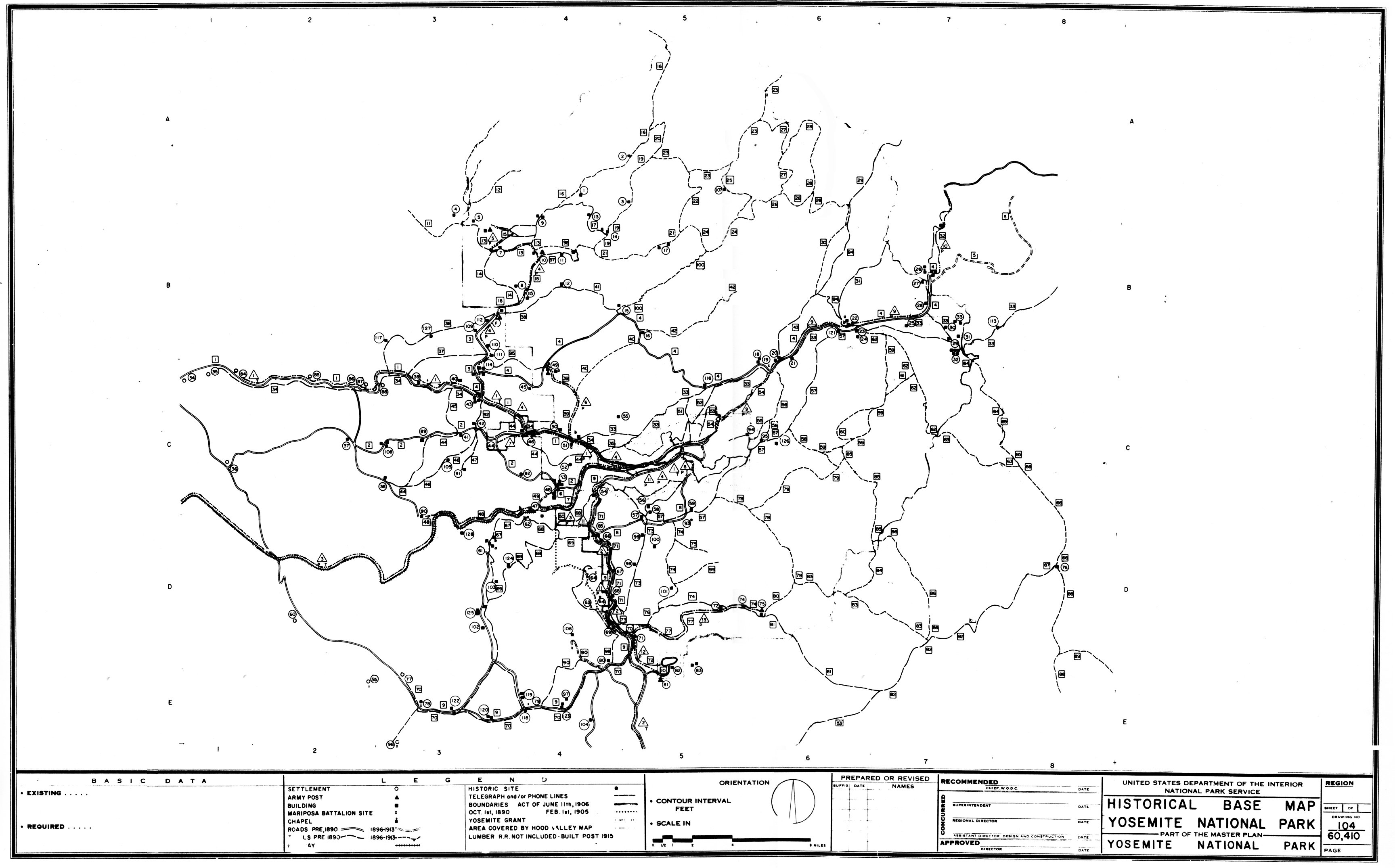
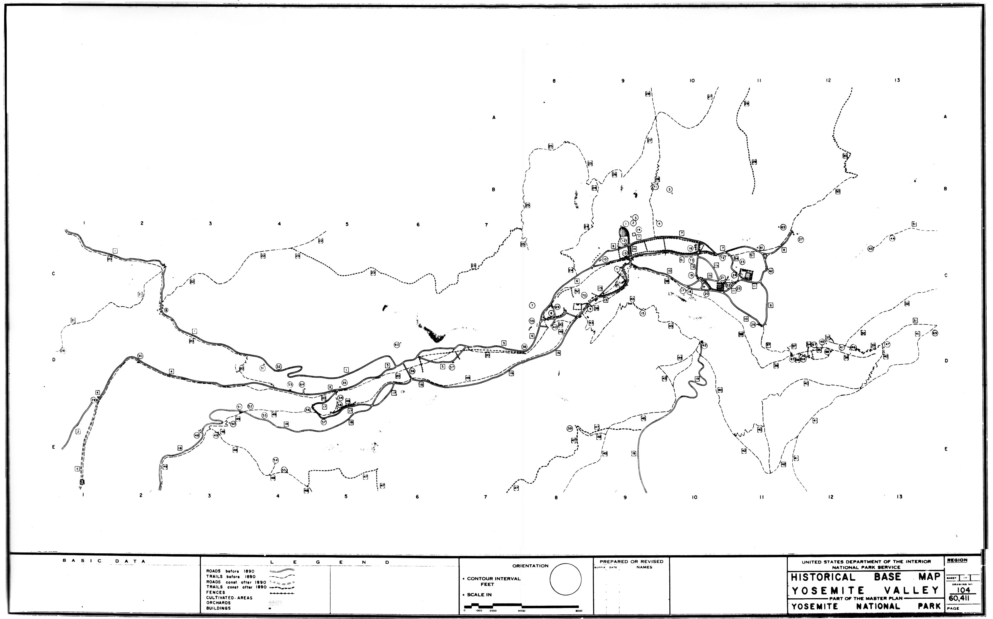
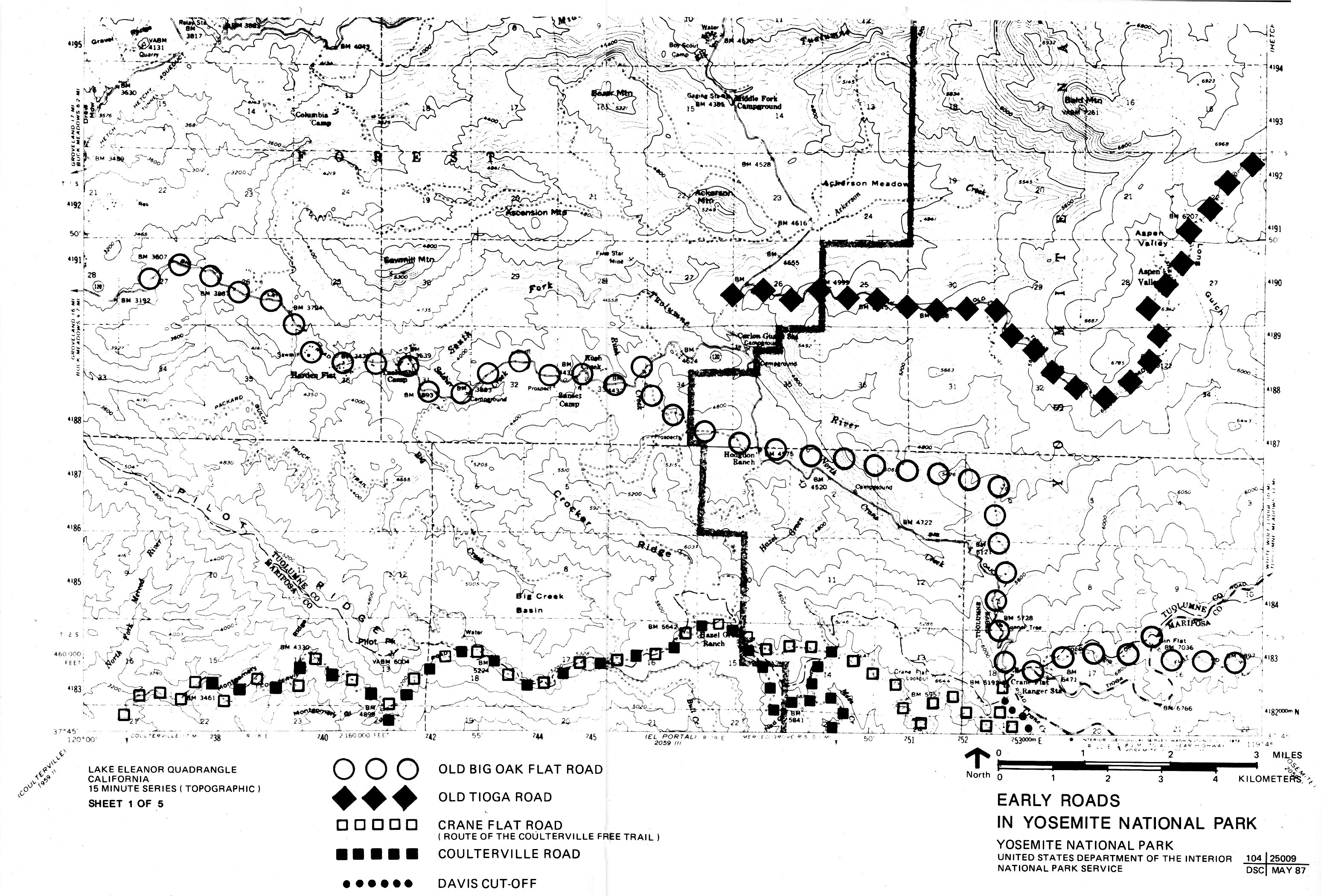
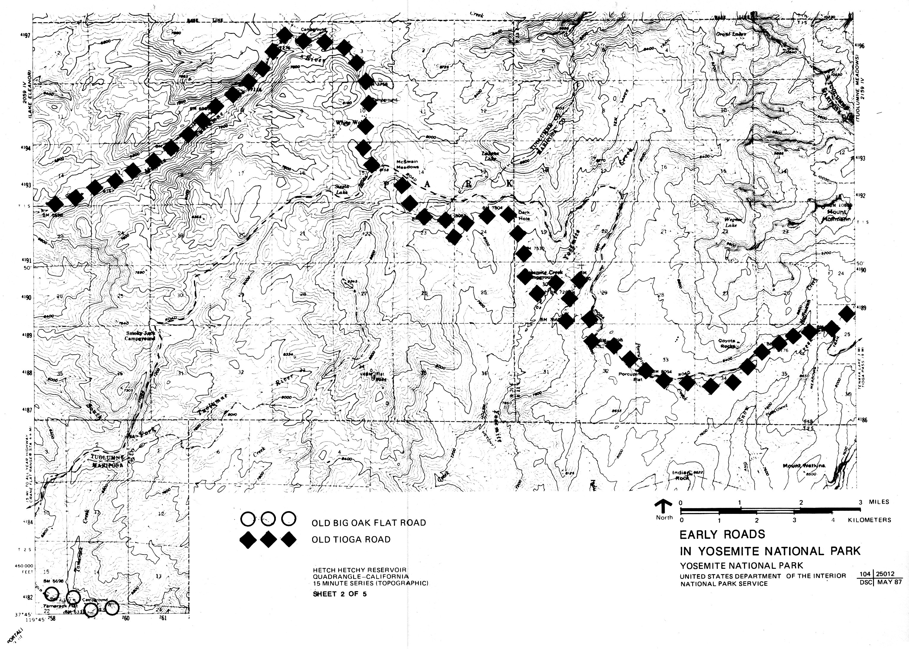
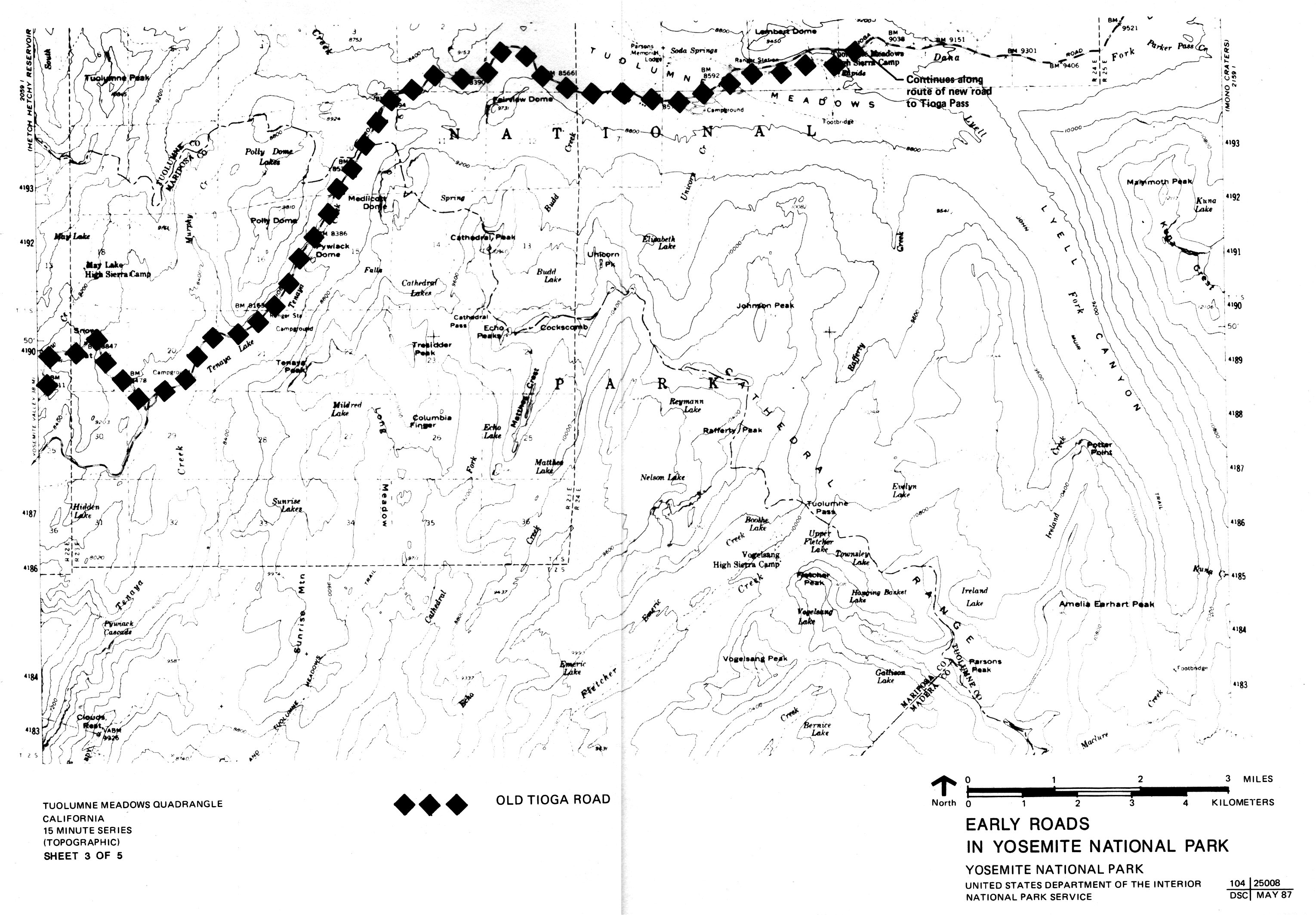
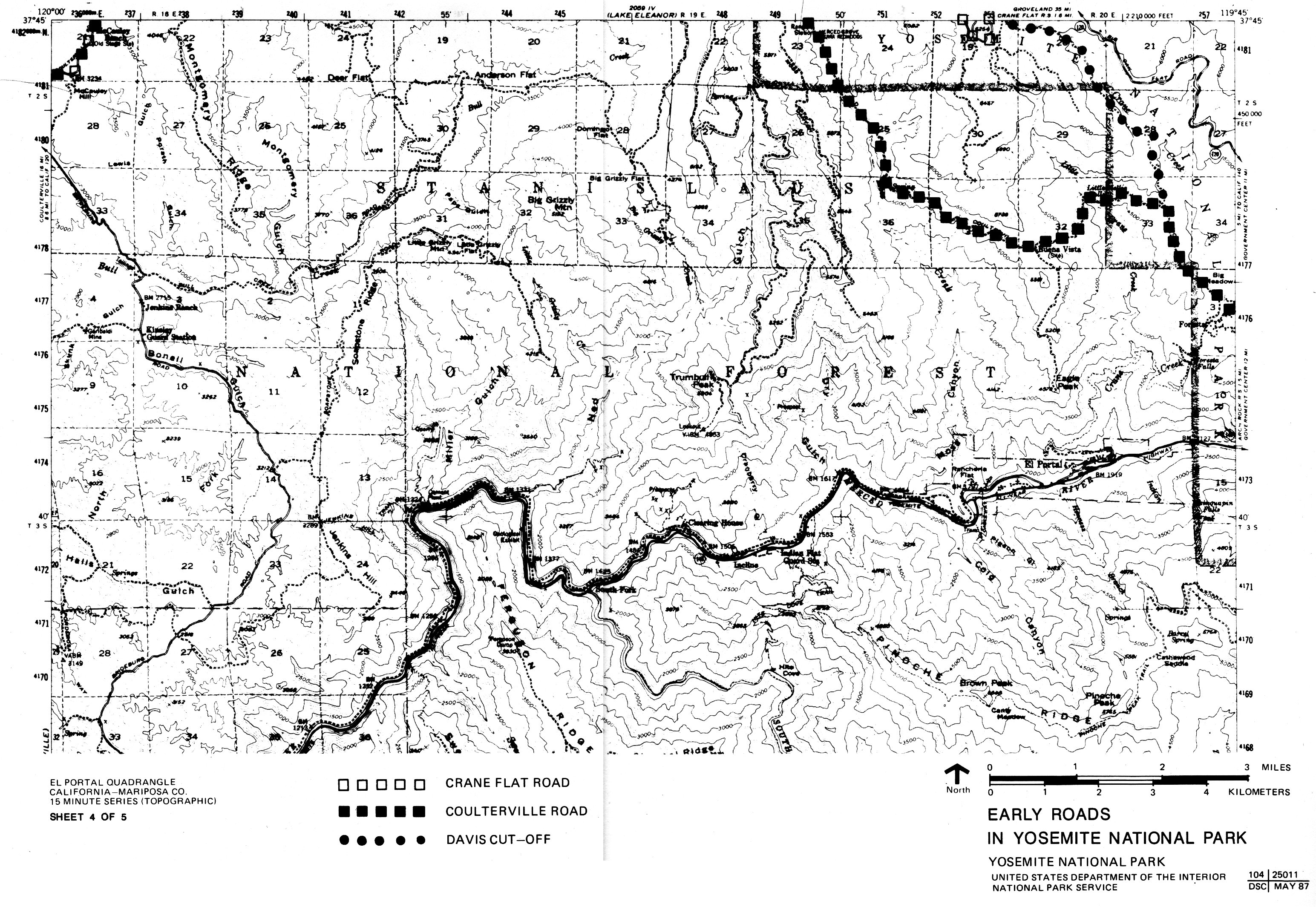
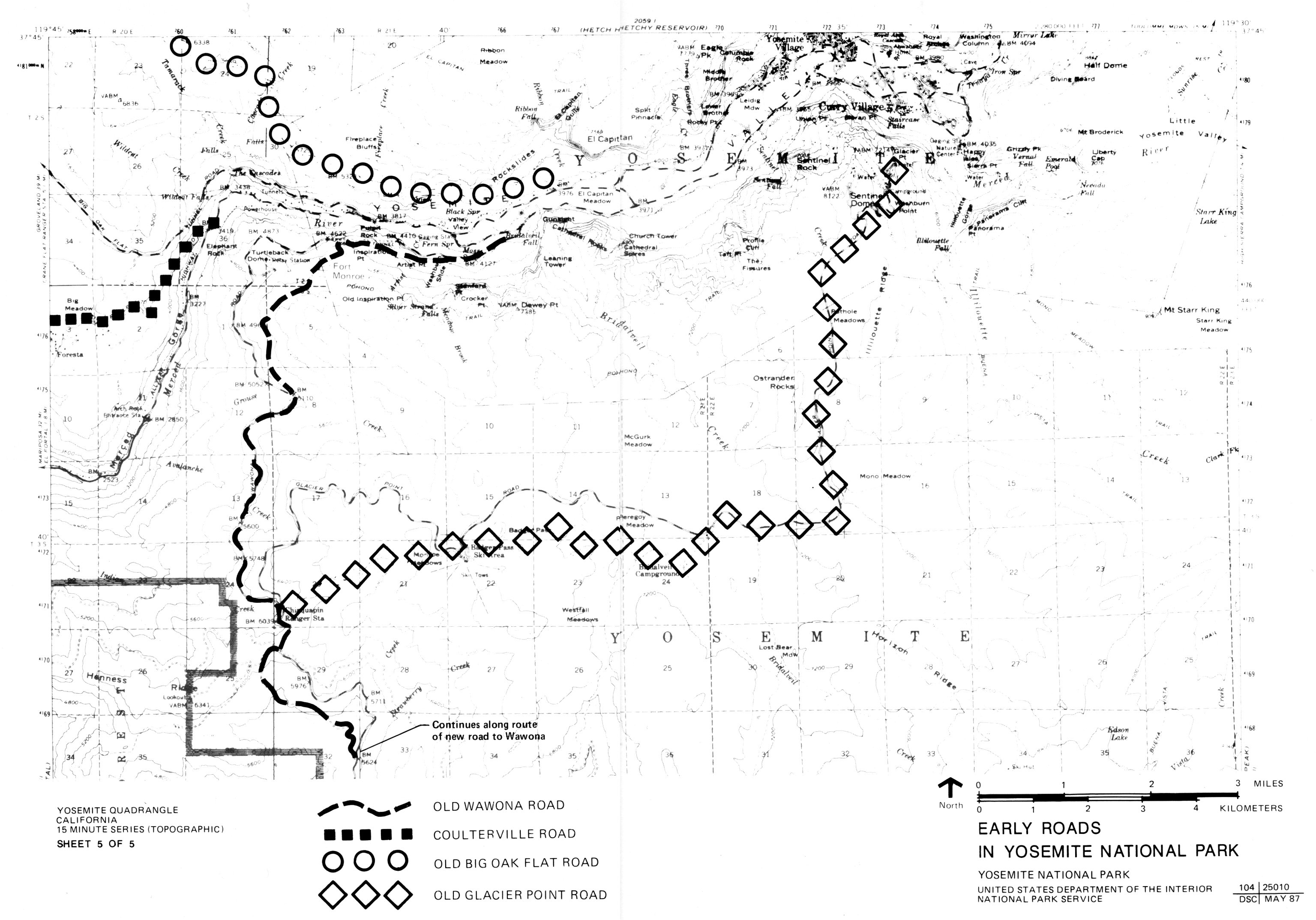
Historical Base Map No. 2.
Early Roads in Yosemite National Park (five sheets)
DSC, #104 25008-12, May 1987.
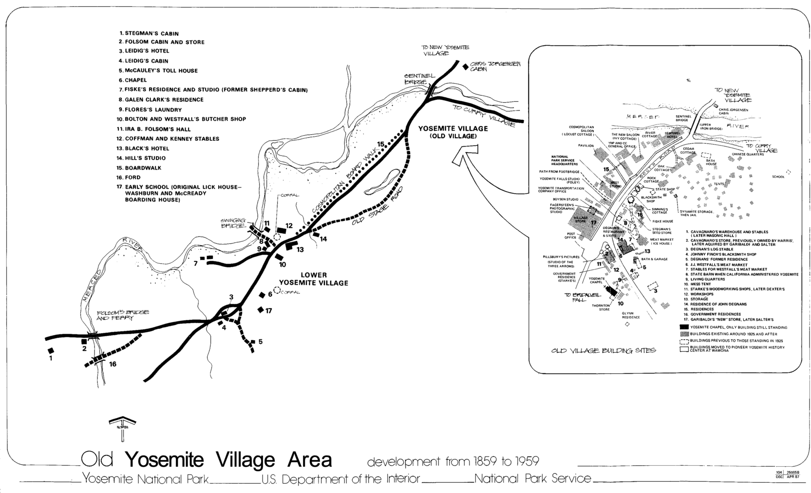
Historical Base Map No. 3.
Old Yosemite Village Area, Development from 1859 to 1959. A variety of
documents provided the information for this map, including secondary
sources and government documents. Locations of Lower Village structures
are approximate.
DSC, #104 25005B, April 1987.
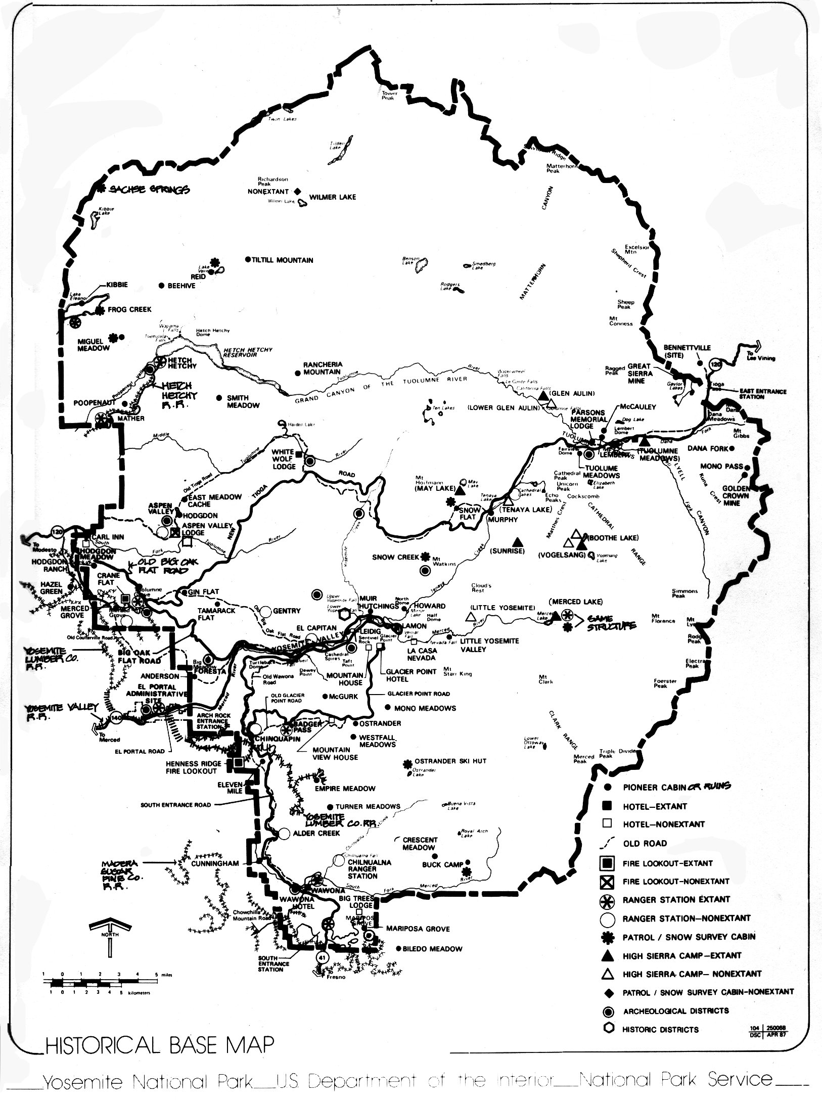
Historical Base Map No. 4.
Yosemite National Park, showing roads, structures, sites, and
archeological and historic districts. (A map from Sargent, Yosemite
& Its
Innkeepers, provided the railroad data.)
DSC, #104 250068, April 1987.
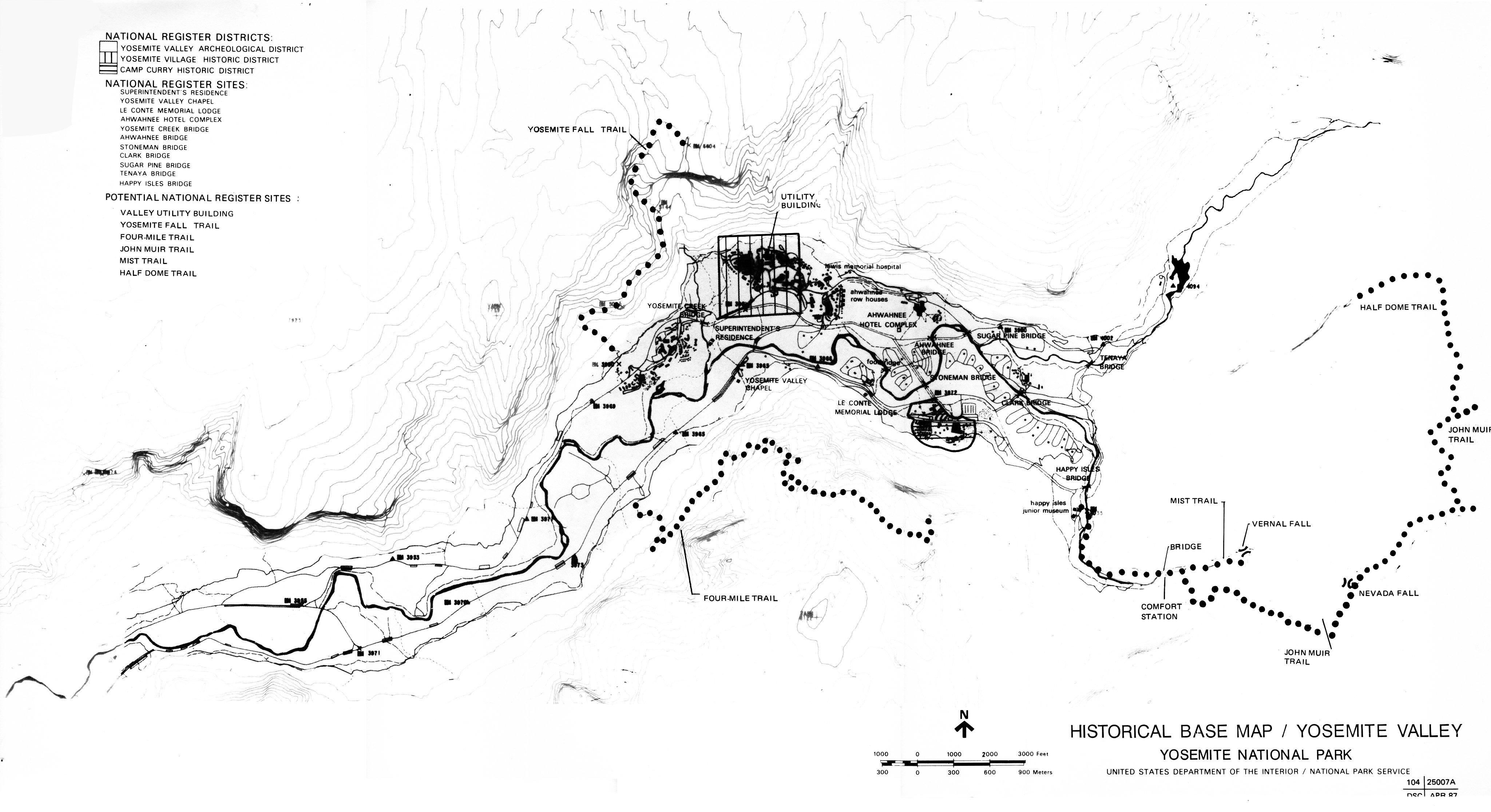
Historical Base Map No. 5.
Districts and sites on the National Register of Historic Places and
potential nominations, Yosemite Valley.
DSC, #104 25007A, April 1987.

![[click to enlarge]](images/map_17a.jpg)